ISLAND CENTER SUBAREA PLAN - BAINBRIDGE ISLAND - City of Bainbridge ...
←
→
Page content transcription
If your browser does not render page correctly, please read the page content below
STEERING COMMITTEE
RECOMMENDED DRAFT

    ISLAND SUBAREA
    CENTER PLAN
        JUNE, 2021   BAINBRIDGE ISLAND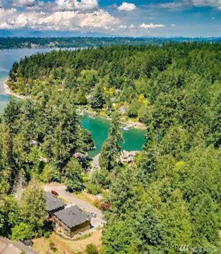
ACKNOWLEDGEMENTS
                   ISLAND CENTER SUBAREA PLANNING PROCESS
                   STEERING COMMITTEE
                   SCOTT ANDERSON

                   JOHN DECKER

                   ASAPH GLOSSER

                   MARADEL GALE, CHAIR

                   DONNA HARUI

                   MICHAEL LOVERICH

                   SAM MARSHALL

                   MICAH STROM, VICE CHAIR

                   MARK TIERNAN

                   CITY COUNCIL LIAISON
                   MICHAEL POLLOCK

                   PLANNING COMMISSION LIAISON
                   JON QUITSLUND

                   DESIGN REVIEW BOARD LIAISON
                   SHAWN PARKS

                   CITY OF BAINBRIDGE ISLAND STAFF
                   JENNIFER SUTTON, SENIOR PLANNER

                   PETER CORELIS, CITY ENGINEER

                   CONSULTANT TEAM
                   FRAMEWORK

                   CAROLLO ENGINEERS

                   TRANSPORTATION SOLUTIONS, INC.

                   WENZLAU ARCHITECTS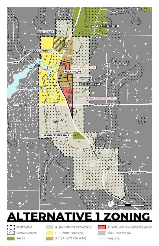
CONTENTS
INTRODUCTION                 1
 COMPREHENSIVE PLAN          3
   LAND USE ELEMENT          4
   NEIGHBORHOOD CENTERS      4
   HOUSING ELEMENT           4
   ENVIRONMENTAL ELEMENT     5
   ECONOMIC ELEMENT          5
   TRANSPORTATION ELEMENT    5

HISTORY + CONTEXT           7
 HISTORY OF ISLAND CENTER    7
 ISLAND CENTER TODAY         9
   LAND USE                  9

COMMUNITY INPUT PROCESS     13
 PLANNING PROCESS           13
 STEERING COMMITTEE         13
 COMMUNITY MEETINGS         14
   COMMUNITY KICK-OFF       14
   PUBLIC MEETING           14
   LIVE POLLING             15
 COMMUNITY SURVEY           16

VISION + GOALS              17
 VISION STATEMENT           17
GOALS                          18
   A. PLACE / IDENTITY           18
   B. BUSINESS / ECONOMY         18
   C. TRANSPORTATION             18
   D. HOUSING                    18
   E. ENVIRONMENT                18

ISLAND CENTER PLAN              19
 LAND USE & ZONING               19
   ISLAND CENTER ZONE            19
   LAND USE                     24
   DEVELOPMENT STANDARDS        24
   POLICIES                     24
   STRATEGIES                   24
 PUBLIC IMPROVEMENTS            27
   COBI OWNED PROPERTY          28
   WATERFRONT ACCESS            29
   POLICIES                     29
   STRATEGIES                   29
 INFRASTRUCTURE                 30
 TRANSPORTATION                 30
   NON-MOTORIZED IMPROVEMENTS   30
   POLICIES                     42
   STRATEGIES                   42

ACTION PLAN                     43
 ACTION STRATEGY MATRIX         43

APPENDIX                        46
FIGURES
FIGURE 1. ISLAND CENTER PLANNING AREA                     2
FIGURE 2 ISLAND-WIDE LAND USE CONCEPT                     3
FIGURE 3. HISTORIC IMAGES OF ISLAND CENTER                8
FIGURE 4. CURRENT IMAGES OF ISLAND CENTER                 9
FIGURE 5. ISLAND CENTER EXISTING ZONING MAP              10
FIGURE 6. AGRICULTURE USES IN ISLAND CENTER              11
FIGURE 7. ISLAND CENTER CRITICAL AREAS                   12
FIGURE 8. OPEN HOUSE                                     14
FIGURE 9. ISLAND CENTER AERIAL VIEW                      20
FIGURE 10. PROPOSED ISLAND CENTER ZONING                 21
FIGURE 11. FOUR CORNERS NODE ZONING                      22
FIGURE 12. ISSEI CREEK NODE ZONING                       23
FIGURE 13. BAINBRIDGE GARDENS NODE ZONING                23
FIGURE 14. CHARACTER IMAGES AND DESIGN EXAMPLES          25
FIGURE 15. ISLAND CENTER ZONE DEVELOPMENT STANDARDS      26
FIGURE 16. PROPOSED PUBLIC IMPROVEMENTS                  27
FIGURE 17. PUBLIC SPACE CONCEPT PLAN FOR COBI PROPERTY   28
FIGURE 18. NON-MOTORIZED TRANSPORTATION IMPROVEMENTS     31
FIGURE 19. STREET IMPROVEMENT CONCEPTS                   33
FIGURE 20. STREET SECTION LOCATIONS                      36
FIGURE 21. STREET CONCEPT SECTION #1                     37
FIGURE 22. STREET CONCEPT SECTION #2.1                   37
FIGURE 23. STREET CONCEPT SECTION #2.2                   38
FIGURE 24. STREET CONCEPT SECTION #3                     38
FIGURE 25. STREET CONCEPT SECTION #4.1                   39
FIGURE 26. STREET CONCEPT SECTION #4.2                   39
FIGURE 27. STREET CONCEPT SECTION #5                     40
FIGURE 28. STREET CONCEPT SECTION #6.1                   40
FIGURE 29. STREET CONCEPT SECTION #6.2                   41
FIGURE 30. STREET CONCEPT SECTION #7                     41
FIGURE A1. ALTERNATIVE 2 PROPOSED ISLAND CENTER ZONING   46
FIGURE A2. ALTERNATIVE 2 PROPOSED ISLAND CENTER ZONING   47
FIGURE D1. SURFACE WATER FEATURES                        53
FIGURE D2. REPRESENTITIVE CROSS SECTION OF AQUIFERS
UNDERLYING THE FLETCHER BAY WATERSHED                    54
FIGURE D3. YEARLY RAIN TOTALS IN INCHES                  54
FIGURE D6. STREAM SYSTEM ‘461’                           57
FIGURE D7. SPRINGBROOK CREEK WATERSHED STUDY LOCATIONS 58
FIGURE D8. LAND COVER CHANGE 2006-2013                   59

THIS PAGE IS INTENTIONALLY LEFT BLANK
INTRODUCTION

Island Center is a designated neighborhood center in the City’s Comprehensive
Plan and located northwest of Downtown Winslow along Fletcher Bay and Issei
Creek. The area includes a mix of commercial, agricultural, recreational, and
residential uses with a rural character defined in large part by naturals features
consisting of forests, habitat, and connections to the water. Neighborhood Center
zoning, which allows for a mix of land uses including commercial and residential
is relatively unique on the Island where most land is zoned primarily for residential
uses and this zoning along with the areas natural features warrant more focused
planning efforts such as a new subarea plan for Island Center. The Island Center
Plan reflects a multi-year planning process led by the Island Center Steering
Committee including members appointed by the City Council and representatives
from the Planning Commission, Design Review Board, and the City Council. The
planning process also included significant opportunities for public input which
has been incorporated into the plan vision, goals, policies, and strategies. Figure 1
shows the Island Center Planning area including the three nodes of development
that were the focus of planning efforts and the concentration of critical areas in
Island Center such as streams and wetlands.

                                                                                        1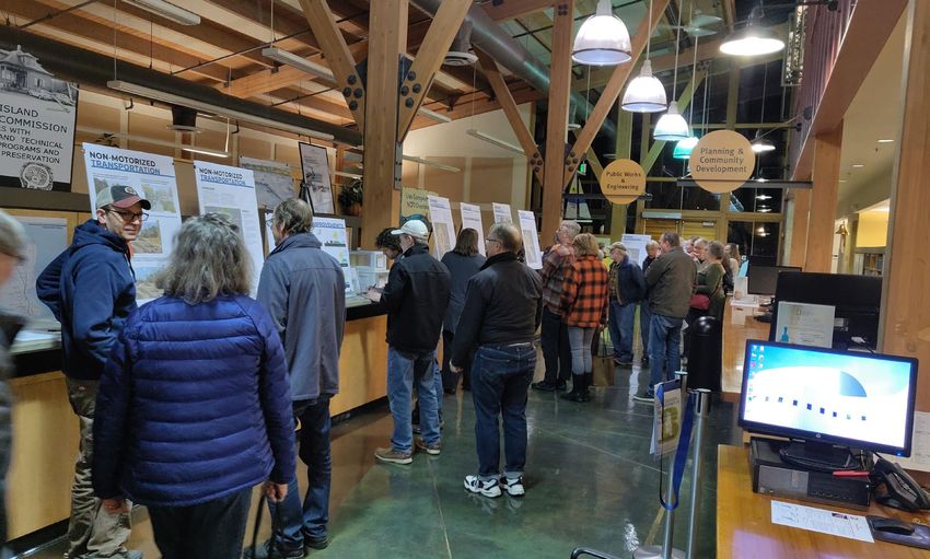
FIGURE 1. ISLAND CENTER PLANNING AREA

    COBI, Framework, 2021

2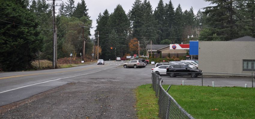
2/28/17
COMPREHENSIVE PLAN                                 FIGURE 2 ISLAND-WIDE LAND USE CONCEPT

Island Center is classified as one of three
Neighborhood Centers in the 2016 update of
the City of Bainbridge Island Comprehensive
Plan. Collectively, Winslow, the Neighborhood                      2/28/17

Centers, and the two Industrial Centers of
Day Road and Sportsman Triangle, constitute
Bainbridge Island’s Designated Centers- see
Land Use Element Figure 2 below. Designated
Centers are referenced and described
throughout the Comprehensive Plan- with
very specific goals and policies in the Land
Use, Economic, Housing and Transportation
Elements by providing an alternative to living,
working and shopping in Winslow. There
are too many Island Center relevant goals
and policies in the Comprehensive Plan
to list them all here, but sampling of these
supporting goals and policies are below.
                                                   COBI, 2017
                                                                                               GOALS & POLICIES
In addition, the Comprehensive Plan
encourages that new development or City            Currently,            the Island
                                                                 GOAL LU-1                      GOALSCenter&Neighborhood     POLICIES
                                                                 Plan for growth based on the growth targets established by the Kitsap Regional

capital projects support improvements to           Center area   2036 and atconsists                 of and thriving             commercial
                                                                 Coordinating Council: 5,635 additional residents and 2,808 additional jobs from 2010-
                                                                               the same time promote            sustain high standards      that will enhance the
                                                  GOAL LU-1 quality of life and improve the environment of the Island.
pedestrian, bicycle and transit access and         businesses
                                                  Plan  for growth
                                                                 Policy based
                                                                             surrounded
                                                                        LU 1.1      on the growth by          targets single-family
                                                                                                                            established by the Kitsap Regional
safety, acknowledging that the designated          residential
                                                  Coordinating             development.
                                                                                    5,635 additional The         residents   Islandand 2,808  Center  additional
                                                                 The City accepts the Kitsap Regional Coordinating Council (KRCC) population allocation
                                                                     Council:
                                                                 and will continue to analyze the impacts of these   allocations as the Comprehensive    Plan is
                                                                                                                                                                     jobs from 2010-
                                                  2036 and atimplemented.
                                                                  the sameWithtime            promote
                                                                                       an allocation         and
                                                                                                     of 28,660,       sustain
                                                                                                                the Island must planhigh      standards
                                                                                                                                      for an increase            that will enhance the
                                                                                                                                                      in population

centers are destinations and must serve            Subarea
                                                  quality        of  Plan
                                                                    5,635
                                                           of life and     personssupports
                                                                            improveand  2,808  jobs by the
                                                                                           the environment  the nonmotorized
                                                                                                           year 2036.
                                                                                                                          of the Island.

through traffic to nearby destinations, such       improvements
                                                  Policy LU 1.1
                                                                                      and         small-scale                     commercial
                                                   development                     described                   in the City’s
                                                                 2016 COMPREHENSIVE PLAN                         LU-3                        LAND USE ELEMENT
as schools and parks. The Comprehensive           The  City accepts the Kitsap               Regional Coordinating                 Council (KRCC) population allocation
                                                  and will continue to analyze the impacts of these allocations as the Comprehensive Plan is
Plan envisions further commercial and              Comprehensive
                                                  implemented.        With an allocation Plan.of The     28,660,residential
                                                                                                                      the Island must plan      densities
                                                                                                                                                       for an increase in population
                                                  ofidentified
                                                     5,635 personsin     andthe 2,808Island
                                                                                          jobs by the     Center
                                                                                                             year 2036.      Subarea Plan
residential development within and near
neighborhood to support Island-wide goals          support smaller single-family dwellings,
to reduce traffic congestion and greenhouse        duplexes or townhomes, and mixed use
                                                  2016 COMPREHENSIVE PLAN                                              LU-3                                       LAND USE ELEMEN
gas emissions and increase sustainability by       development such as flats above commercial
locating housing and commerce together in          space, but are not dense enough to support
compact areas. The Island Center Subarea           the multifamily development such as
Plan acknowledges Island Center’s location         multistory apartment buildings. Review and
close to agricultural areas, and envisions         approval of the Island Center Subarea Plan by
development in Island Center that can support      the Planning Commission and City Council will
that nearby agriculture.                           coincide with review of Island Center specific
                                                   Comprehensive Plan amendments.

                                                                                                                                                                  3
LAND USE ELEMENT NEIGHBORHOOD CENTERS
GOAL LU-4 The Neighborhood Centers provide Island-
wide commercial and service activity outside
As part of a long-term Island-wide Winslow. These areas are to be developed
Conservation and Development Strategy, at higher densities to reinforce their roles
focus residential and commercial as community centers. The neighborhood
development in designated centers, increase centers will help reduce traffic congestion
a network of conservation lands, maximize by providing an alternative to shopping in
public access while protecting the shoreline, Winslow.
minimize impacts from the SR 305 corridor
and conserve the Island’s ecosystems and the Policy LU 9.1
green and open character of its landscape.
The Neighborhood Centers provide Island-
Policy LU 4.2 wide small-scale commercial and service
activity and mixed-use development outside
Adopt a multi-year work program to Winslow.
undertake the subarea planning for the
designated centers of Island. Policy LU 9.2
Policy LU 5.1 Orient development toward the pedestrian.
Retail uses are encouraged on the ground-
Winslow is the urban core of the Island while floor to prevent blank walls with little visual
the Neighborhood Centers are smaller-scale interest for the pedestrian. Offices and/
mixed-use centers. In order to achieve the or residential uses are encouraged above
goals of the GMA this Plan: ground floor retail.
Encourages development in areas where
public facilities and services exist or can HOUSING ELEMENT
be provided in an efficient and effective
manner. Policy HO 3.7
Provides a vibrant, pedestrian-oriented Expand opportunities for infill in the residential
core. neighborhoods of the Winslow Master Plan
Reduces sprawl. study area and the Neighborhood Centers.
Allow the creation of small lots (e.g., in the
Provides choice of housing location and
3,000 square foot range) as well as smaller
lifestyle.
footprint homes (e.g., under 1,200 square feet)
Maintains and protects environmentally
sensitive and resource lands. GOAL HO-6
Encourages the retention of open space. Facilitate the provision of a diverse affordable
Maintains and enhances fish and wildlife housing stock in all geographic areas of the
habitat. community.
Policy LU 5.8
Adopt development standards and program
public improvements to encourage walkability
within each designated center and to the
surrounding areas.
4ENVIRONMENTAL ELEMENT GOAL EC-6
GOAL LU-15 As the city’s designated centers evolve,
balance their functions as places of
Promote food security and public health commerce and employment with their roles
through support for local food production, helping to meet housing needs and provide
awareness of farming practices. Encourage focal points for civic engagement and cultural
locally-based food production, distribution enrichment.
and choice through commercial and urban
agriculture, community gardens, farmers’ Policy EC 14.1
markets, farm stands and food access Support the market for Island-grown
initiatives. agriculture products by:
GOAL EN-15 Recognizing and supporting the
Bainbridge Island Farmers’ Market,
Conserve and protect the Island’s existing including permanently dedicating space
agricultural uses and increase the acreage for the market and enhancing the market
of permanently protected and productive area.
farmland by using preservation methods
Allowing and promoting roadside stands
including incentive-based programs.
that sell Island-grown products.
Policy EN 15.1 Promoting and supporting Community
Supported Agriculture (CSA).
Provide owners of farms the option of
participating in the transfer of development Encouraging the development of value-
rights (TDRs)/purchase of development rights added processing facilities that can be
shared by many farmers.
(PDRs) program.
Encouraging food crops to be planted on
public land.
ECONOMIC ELEMENT
Policy EC 1.4 TRANSPORTATION ELEMENT
Support entrepreneurism by providing MOTORIZED SYSTEM
adequate land use designations in keeping
GOAL TR-2
with the character of the Island, while
avoiding investment in sectors, activities, or Provide a non-motorized transportation
infrastructure that will not remain viable in the system that is a planned and coordinated
foreseeable future. network of shoulders, sidewalks, trails,
footpaths, bikeways and multi- purpose trails
Policy EC 1.5
that connect neighborhoods with parks,
In order to provide opportunities for business schools, the shoreline, the ferry terminal and
enterprise, adequate space must be provided commercial areas.
for efficient use of existing developed areas
Policy TR 2.1
near public transportation (e.g. ferry, bus
service) and for growth that recognizes and Provide a non-motorized transportation
protects the Island’s valued natural amenities, system that effectively serves the needs
its limits of land and water and the quality of of people of all ages and abilities who
its residential neighborhoods. walk, bike, or ride horses, or use wheel
5chairs; encourages non-motorized travel;
and provides continuous networks of safe,
efficient and attractive shoulders, sidewalks,
pathways (footpaths), and multi-purpose trails
throughout the Island that are also connecting
to regional systems.
Provide safe and appropriately scaled non-
motorized access that connects designated
centers, the ferry terminal, services such as
a doctors’ offices, schools, parks, recreation
areas, shorelines (including road-ends), and
transit connections including to ferry and bus
services.
PARKING
GOAL TR-10
The availability of public parking is an asset
to commercial districts and a benefit to
island residents and visitors. Parking is a vital
element of the designated centers.
Policy TR 10.2
Preserve on-street parking in the mixed-
use commercial districts of Winslow
and designated centers. City projects in
commercial districts should maximize parking
to the extent practical within the existing rights
of way. Note that “Complete Streets” projects
must also balance other functions such as
non-motorized uses. Seek opportunities to
expand public parking.
6ISLAND CENTER
HISTORY + CONTEXT
HISTORY OF ISLAND CENTER
Bainbridge Island is within the aboriginal Center emerged as an agricultural community
territory of the suq̀ʷabš, “People of Clear Salt with a shipping route connecting Fletcher
Water” (Suquamish People). Expert fishermen, Bay to Seattle, Manzanita, and Brownsville.
canoe builders, and basket weavers, the The Kitsap County Transportation began
Suquamish people live in harmony with the operating steamboat service along the route
lands and waterways along Washington’s in 1917, as Fletcher Bay was becoming a
Central Salish Sea and Bainbridge Island resort destination. Foster’s Resort, later taken
as they have for thousands of years. The over by the Hamilton family and renamed
Suquamish People first inhabited Bainbridge Hamilton’s was established on Fletcher Bay
Island and the Kitsap Peninsula around 13,000 in 1912 and a post office began operating out
years ago and continue to live in the area of the resort in 1915. Island Center Hall which
to the present day. The Suquamish People remains a focal point for the community to
occupied winter villages and seasonal camps this day was donated to the Island Center
throughout the island as they fished, hunted, Improvement Club in 1913.
collected shellfish, and gathered plants and
other vegetation resources. Several areas on Many Island Center’s historic buildings and
the island have religious significance to Tribal sites, many of which remain to this day tell the
members and some areas near the marine story of the whole Island. Bainbridge Island’s
shoreline were burial sites. Many significant current historical museum in Winslow, was
cultural resources have been documented the Island Center community’s original one-
along the contemporary marine shoreline of room schoolhouse, constructed in 1908, and
Bainbridge Island. Inland portions of the island was moved to Winslow after serving as the
have not been investigated as intensively as Bainbridge Island High School’s band and
shoreline landforms but likely have evidence choir room from 1923 on. Bainbridge Gardens,
of past Suquamish land use. which is still operated by the Harui family, was
a local nursery and grocery store in Island
Non-native settlement of the Island began Center frequented by Japanese-Americans in
in 1853 when George Anson Meigs ventured the area. Nearby, the Kodama family farmed
into Puget Sound to establish a lumber mill. berries on Fletcher Bay with the help of the
Bainbridge Island was a historic center of Felix Narte and others, who maintained the
logging and shipbuilding in the 19th century, farm while the family was interned during the
a history that Island Center shares with many Second World War.
of the communities on the Island. After old
growth forests in the area were cleared, Island
7FIGURE 3. HISTORIC IMAGES OF ISLAND CENTER
COBI, 2021
8ISLAND CENTER TODAY Much of the land around Fletcher Bay is
within a critical aquifer recharge area. There
are two creeks that run through Island Center
Island Center is still a center of agricultural into Fletcher Bay: Springbrook Creek and
land in Kitsap County, with some working Issei Creek. These streams are surrounded by
farms and agricultural uses within and around critical areas and connect wetlands around
the study area. Although the Study Area is Fletcher Bay. Fletcher Bay is under 250 feet
a hub for local commercial services, single from Miller Point Rd and there is no direct
family homes are the predominant form of connection to the waterfront along Fletcher
development. There are limited commercial, Bay. The section of Fletcher Bay on which
civic, and cultural uses along Fletcher Bay several properties in the Study Area are
Rd NE and Miller Rd NE, with clusters of located is primarily intertidal area, where Issei
commercial uses near the intersection with and Springbrook Creeks deposit sediment on
NE New Brooklyn Rd and the intersection the eastern end of the Bay.
with Battle Point Road. There is a City-owned
4-acre parcel between these two intersections LAND USE
that is used as a staging area for public works
projects, and intermittently as parking for The Island Center planning area consists of
Congregation Kol Shalom, located just north mostly single-family homes, agriculture uses,
of the lot. Island Center Cemetery abuts this and neighborhood commercial uses. Figure
municipal property to the northeast, east of 5 shows the existing zoning for Island Center
Kol Shalom. Much of the current development including the neighborhood commercial zone
in Island Center came in during the latter shown in red.
half of the 20th century. Island Center Hall, a
90-year-old meeting hall is the only historic
building in the Study Area on it southern end.
FIGURE 4. CURRENT IMAGES OF ISLAND CENTER
COBI, 2021
9FIGURE 5. ISLAND CENTER EXISTING ZONING MAP
COBI, Framework, 2021
10FIGURE 6. AGRICULTURE USES IN ISLAND CENTER
As shown in Figure 6,
Island Center has a
high concentration
of agriculture and
equestrian related
uses.
COBI, Framework, 2021
11FIGURE 7. ISLAND CENTER CRITICAL AREAS
Island Center has a
high concentration
of critical areas
including fish
bearing streams,
wetlands, and
steep slopes that
limit development
potential on several
parcels. Issei Creek
and Springbrook
Creek are both
salmon bearing
streams that
drain to Fletcher
Bay. Critical areas
and buffers are
generally protected
from development,
but development
regulations allow
density to be
transferred to other
parts of the site that
are outside of the
critical area of buffer.
More information
is available in
Appendix D: Island
Center Subarea
and Fletcher Bay
Watershed State of
the Water.
COBI, Framework, 2021
12WHAT WE HEARD –
THE COMMUNITY INPUT PROCESS
PLANNING PROCESS STEERING COMMITTEE
This Island Center Subarea Plan is called for The Island Center Steering Committee,
by the Bainbridge Island Comprehensive appointed by the City Council formed in 2018,
Plan’s Land Use Policy 4.2 (LU 4.2) which is composed mostly of residents and business
specifies a “multi-year work program owners in or near Island Center, has held over
to undertake subarea planning for the 40 meetings between since then, including
designated centers”, including Island Center. one public workshop. The public was able to
The subarea planning process is further attend and comment at steering committee
outlined in Bainbridge Island Municipal Code meetings, and members of the public have
(BIMC) Section 2.16.210. A previous Island offered input at each meeting through the
Center subarea planning process took place process, and at the public workshop where
between 2000 and 2002. A draft Island they were able to offer written feedback on
Subarea Plan was developed, but not adopted potential roadway improvements and land
by City Council. use alternatives. The committee has helped
assess existing conditions and development
In 2017, the City Council identified Island project goals, a vision statement that address
Center subarea planning as a priority. The land use, public space, environmental
Council then appointed a steering committee, resources, and waterfront access.
which has been meeting and gathering
information and developing ideas for the
future of Island Center. Subarea planning for
Island Center in 2018 with an “Envision Island
Center” community kick-off and a survey to
gather input from the public on identity and
sense of place, environment, business and
economy, and transportation and circulation.
The steering committee met regularly since
the project kick-off in 2018 until plan adoption
in 2021.
13COMMUNITY MEETINGS A desire to improve the conditions and
access to existing businesses
A desire to protect water quality and
COMMUNITY KICK-OFF address any stormwater impacts
JUNE 18, 2018 A full summary of the meeting and public
input are located in Appendix B.
The City and the Island Center Steering
Committee hosted a public meeting on
June 18, 2018 to kick-off the project with the PUBLIC MEETING
community and receive input on the direction FEBRUARY 10, 2020
of the plan and a new vision. The following
were key themes from the meeting: A public meeting was hosted by the Island
Center Steering Committee and held at City
A desire to maintain the rural character Hall on February 10, 2020. Over 100 people
Concerns around upzoning, sewer service, attended, and the meeting include an open
and increasing the pace of growth house for the first half hour with project
information boards followed by a presentation
A desire for pedestrian and bicycle from the committee on the plan alternatives
improvements including trails followed by questions and discussion with the
A desire for human-scaled development public.
and avoiding large scale buildings
FIGURE 8. OPEN HOUSE AT THE FEBRUARY 10, 2010 PUBLIC MEETING
Framework, 2020
14LIVE POLLING
Meeting attendees were asked to respond to questions using smartphones on the site www.
slido.com or via paper surveys. The word cloud and response summaries below include all
responses. Word clouds were generated on worditout.com.
1. WHAT BUSINESSES WOULD YOU LIKE TO SEE IN ISLAND CENTER? (LIST UP TO THREE)
2. WHAT ACTIVITIES WOULD ENHANCE ISLAND CENTER? (LIST UP TO THREE WORDS)
3. WHAT IS THE IMPROVEMENT THAT IS MOST IMPORTANT TO ISLAND CENTER? (LIST
UP TO THREE WORDS)
15COMMUNITY SURVEY In many cases these highest ranked goals
ranked closely to other, sometimes closely
The Island Center community survey related priorities for the community, which
opened for public response shortly before included:
the community kick-off in June 2018 and
was open for one month before results were Environment: Protect and preserve surface
tabulated in July. 652 people completed the and groundwater, wildlife and wooded
survey online and 14 completed hard copies areas;
of the survey, which were included in the Identity & Sense of Place: Recognize and
overall results. During the time the survey was honoring the history of Island Center;
open, the planning team received 393 emails
Business and Economy: The creation of
from the public related to the planning effort.
new, sustainable businesses that benefit
Many respondents lived in the Island Center
the community and are appropriate in
area (59%), and the vast majority (91%) were
scale and design; and
homeowners.
Transportation & Circulation: Improve
The survey asked the public to rank different pedestrian mobility, traffic circulation, and
elements of a vision for Island Center that fell safety.
under four broader categories: environment,
identity and sense of place, business and By far the category that ranked as most
economy and transportation. The highest important among the general public was
ranked response for each of these subject environment, with 42.3% of respondents
areas are listed below along with the percent ranking it “most important”, followed by
of respondence who ranked that goal as the identity and sense of place with 26.1%,
most important: business and economy with 17.5%, and finally
transportation and circulation with 11.5%. Each
Environment: Preserve, protect, and of these priorities and goals for the plan have
restore natural features—forests, been incorporated in the vision for Island
vegetation, streams and the bay. (68%) Center developed by the steering committee
Identity & Sense of Place: Enhance the and the elements of this plan the help further
sense of community at Island Center and that vision.
make it a place where people want to
meet and spend time. (42%)
Business & Economy: Recognize the
importance of the existing business
community and help it thrive. (47%)
Transportation & Circulation: Add
sidewalks, trails and pedestrian-
scaled amenities to make the area a
safer, enjoyable place for pedestrians,
equestrians, and cyclists. Encourage
public transit and alternative modes (58%)
16VISION + GOALS
The Steering Committee, advised City staff and consultants, developed a vision for the Island
Center Subarea which emphasizes environmental sustainability, as well enhancing and
highlighting Island Center’s natural setting. This vision is captured in the statement articulated by
the Committee in 2018, which has shaped the planning process, goals and guiding principles for
the Island Center Subarea Plan. The goals developed together with through the planning and
engagement process draw heavily from this statement and are included in this section.
Island Center is an area rich in natural resources that we strive to maintain,
VISION STATEMENT
enhance and restore. It provides residents and others with an abundance of
diverse outdoor activities to enjoy and a small variety of parks, open space
and other places to gather as a community. Its ability to provide residents
with a sense of community has served its residents well. Proximity to the
Grand Forest is a special feature of Island Center and visitors to the Grand
Forest often explore the Island Center business community as well.
A network of local trails and paths gives its residents and others a safe way
to move about without fear of vehicle traffic. Traffic calming measures and
improved intersections make roads in Island Center safer and provides
pedestrians, cyclists and those using alternative modes of transportation a
safe option.
Local commerce provides the area with a small diverse option of
appropriately scaled businesses that serve the community well and blend
into the area.
Diverse new housing has been incremental in-fill through the years. Limited
zoning changes provide better use of the natural topography and promote
safety while keeping the original feel of the small tight knit community of
Island Center now and for years to come.
Business and residential developments and zoning preserve, enhance and
strive to improve and restore the existing beauty of the land and water: Issei
and Springbrook Creeks and Fletcher Bay.
17GOALS D. HOUSING
Integrate a diverse range of low, moderate
and middle income housing availability
A. PLACE / IDENTITY
Allow increased density when
Enhance Island Center’s sense of accompanied by sufficient public benefit
community and make it a place where Utilize approaches aligned with the
people want to visit and spend time Comprehensive Plan
Recognize and encourage continued
agricultural and horticultural uses E. ENVIRONMENT
Link and celebrate the parks, open spaces,
Preserve, protect, and restore natural
services and attractions in and near Island
features including salt water bodies,
Center
shorelines, stream corridors, open spaces
Ensure new development reinforces and stands of mature trees
physical character and social connections
Provide better visual and public access
Guide built environment by incorporating between Fletcher Bay, the Grand Forest
existing/historic character and fostering a and other local open spaces & attractions
diverse design aesthetic featuring a mix of
Protect watershed viability, surface and
small-scale buildings
groundwater, including aquifer recharge,
Preserve and enhance Island Center’s and take steps to ensure that water
natural environment and landscape quality and natural shoreline conditions
character on Fletcher Bay are maintained, if not
improved
B. BUSINESS / ECONOMY Emphasize the maintenance and
Recognize and help the existing business protection of habitat for fish & wildlife
community thrive and diversify Ensure that development minimizes and
Encourage creation of new, independent, mitigates significant impacts on natural
economically and environmentally systems to prevent net loss of ecological
sustainable businesses that benefit function and/or any increase to air, noise,
community and align with Design and light pollution
Guidelines & Standards
C. TRANSPORTATION
Improve mobility, circulation, and safety for
all transportation modes
Ensure available parking is aligned
with housing, business and community
needs while minimizing its impact on the
environment
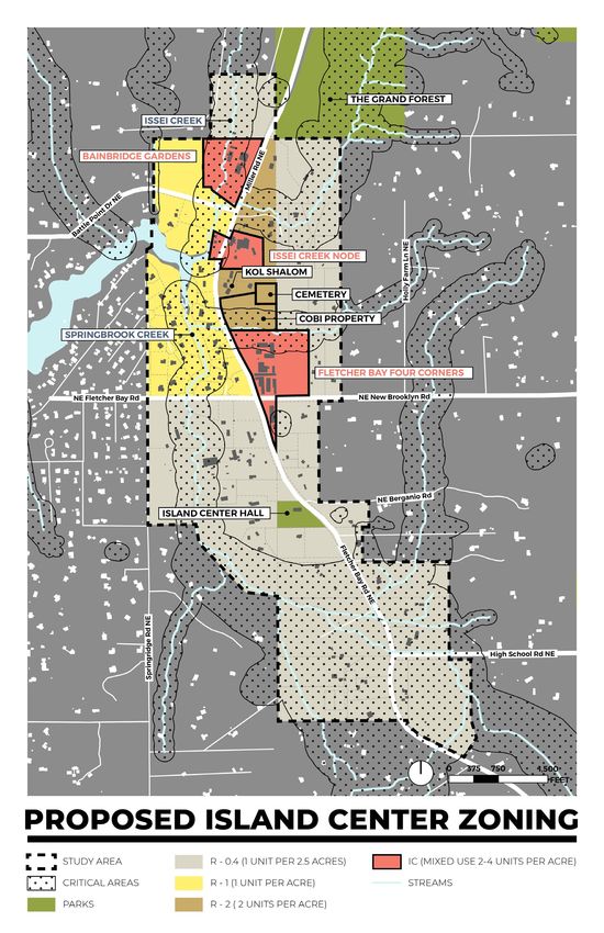
18ISLAND CENTER PLAN
LAND USE & ZONING
ISLAND CENTER ZONE
The Island Center Plan focuses on three There is healthy debate regarding the many
nodes of neighborhood center zoning within root causes of housing affordability, including
the study area (see Figure 10). The residential historical use of exclusionary zoning, over-
zoning for all areas outside of the three nodes reliance on single family housing, design
will remain the same and no changes are standards that increase building costs,
proposed. A new zoning district called the dramatic shifts in the local economy, lack of
Island Center Zone is an Island Center specific subsidized housing, and many more. However,
neighborhood commercial zone that modifies it is clear that inventory of homes for sale is
the standards of the existing Neighborhood currently at historic lows, and that demand
Center Zone (see Figure 15) and Appendix C for housing on Bainbridge has dramatically
Recomended Island Center Use Table. The eclipsed supply. As this drives up prices, it
neighborhood center zoning is proposed to makes living on the island increasingly out of
be expanded in all three nodes-Bainbridge reach for low- and middle-income workers.
Gardens, Issei Creek and Four Corners nodes.. Our proposed approach seeks to, in a modest
way, increase overall housing stock and
In developing this plan, the committee specifically target increases for low- and
recognizes the increasing housing affordability middle-income workers. We do not expect
crisis on Bainbridge Island and in the broader that it will solve the problem alone, but we are
region. As a community committed to being also unwilling to shirk our responsibility to be
welcome and inclusive, we recognize that part of the solution.
housing affordability is a cornerstone of these
values.
We understand that there are ongoing
conversations at the broader city level that
seek to develop long-term, island-wide
approaches to address affordability. However,
we also believe it is our duty as members
of this committee to advance a plan that
reflects these values as well. Though our
proposed changes in zoning and affordability
incentives along will not solve this problem,
they represent an affirmative statement of our
commitment to this goal.
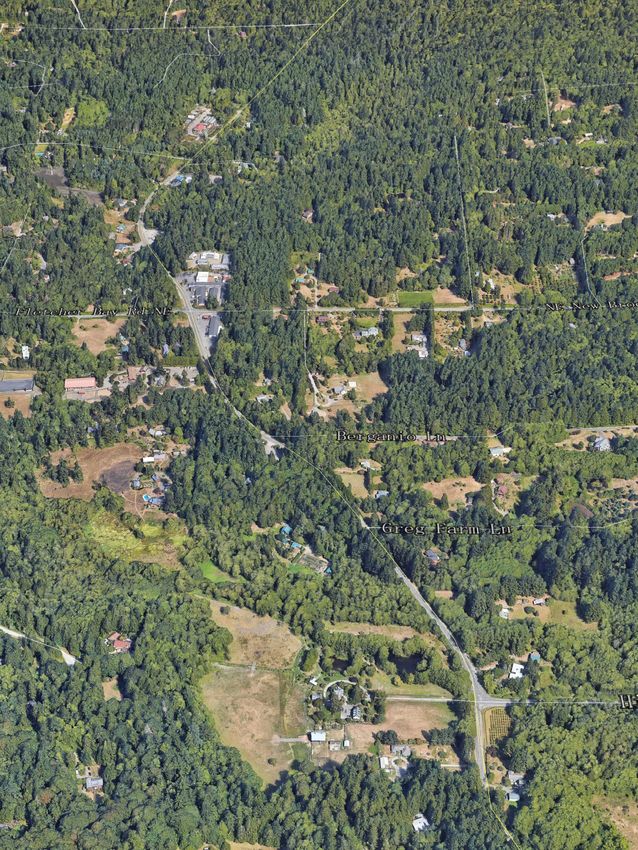
19FIGURE 9. ISLAND CENTER AERIAL VIEW
RD
R
LE
IL
M
BATTLE POIN
T
FLETCHER BAY RD NE NEW BROOKLYN
BERGANIO LN
GREG FARM
FL
ET
CH
ER
BA
Y
RD
HIGH SCHOOL RD
Framework, 2021
20FIGURE 10. PROPOSED ISLAND CENTER ZONING
Framework, 2021
21Holly Farm L
FIGURE 11. FOUR CORNERS NODE ZONING Four Corners Node
The Four Corners node
expands neighborhood center
zoning to the east to include
the approximately 5 acres
north of NE New Brooklyn Rd.
These 5 acres have common
ownership with the property
at the NE corner of Miller and
New Brooklyn Road. Like other
Island Center Neighborhood
Center properties, the
properties along Miller Road
have long been developed with
New Brooklyn
NEcommercial Rd
uses, including
self-service storage and
currently, Bainbridge Rental
(equipment rental), a gas station
and restaurant. Improving safety
for accessing commercial
properties has been identified
as a goal for this Plan. Adding
to the Island Center zone to the
Framework, 2021
east of this area allows room for
redevelopment or reorganizing
of the layout of commercial
properties (that front on Miller
Road) over time. Any major
changes to these properties will
anio to
require improvements Rd
the
NE BergWith
ingress/egress. current
and future Island Center zone
properties already developed
with thriving commercial
businesses, the additional 5
acres of Island Center zoning
is perhaps the only proposed
Fle
change in this Island Center
plan that may add residential
tch
development in the near term.
er
The properties shown in red in
Figure 11 through Figure 13 are
ayB
proposed for inclusion in the
Island Center Zone within each
R dN
node.
E
22R
le r
M il
FIGURE 12. ISSEI CREEK NODE ZONING Issei Creek Node
In the Issei Creek node
neighborhood center zoning
is proposed to be expanded
to the west of Miller Bay Rd
NE and south of the existing
neighborhood commercial on
the east side of Miller Bay Rd
NE. The properties shown in red
in Figure 12 are proposed for
inclusion in the Island Center
Zone.
Framework, 2021
FIGURE 13. BAINBRIDGE GARDENS NODE ZONING Bainbridge Garden Node
The Bainbridge Gardens Node
is proposed for inclusion in the
Island Center Zone to reflect the
long-term existing commercial
use.
NE
Rd
ler
NE New Br
Mil
Framework, 2021
23LAND USE POLICIES
Significant changes to the land uses that Require a principal commercial use for
are currently allowed in the Neighborhood development in Island Center.
Commercial Zone are proposed to focus Prioritize land uses that serve the
on community priorities for Island Center. surrounding Island Center area.
Because neighborhood commercial zoning is
very limited on Bainbridge Island properties Consider changes to residential densities
must have a primarily commercial use as part of a City-wide strategy for
with specific opportunities for mixed-use affordable housing and land conservation.
development that includes residential uses. Allow residential uses when part of a
See Appendix C for a chart of recommended mixed-use development including single-
land uses to be adopted into the City’s zoning family when not located along primary
and development code. street frontages.
Encourage the development of affordable
DEVELOPMENT STANDARDS housing in Island Center for a range of
household incomes.
The development standards shown in Figure
Ensure new development is small-scale,
15 are proposed to implement the vision and
has a rural character, and prioritizes places
goals for Island Center and vary by node. The
for people in public spaces.
development standard recommendations
were crafted with the Island Center Steering Minimize negative impacts from vehicles in
Committee and input from the public during the design of new development including
Steering Committee meetings. Development access, the location and design of parking,
standards maintain the same base density as and street frontages.
the existing Neighborhood Commercial Zone Require active street level uses in the
and allow bonus units for affordable housing Island Center Zone.
with a 50% affordable housing requirement.
Encourage agricultural and supporting
For properties newly added to the Island
uses in Island Center, including improving
Center zone, underlying base density remains
the City’s Transfer of Development rights
the same as its current residential zoning (e.g.
program or other agriculture preservation
R-1) with a higher amount of bonus density
programs.
available for affordable housing. Buildings
must be designed to be human-scale with On split zoned parcels allow or require
limits on building widths at the street frontage, the transfer of density into the IC Zone to
building footprint limits, and requirements for preserve land.
active uses and features at the street level. Allow for non-conforming uses to relocate
Residential unit sizes are capped at 1,800 buildings within a property on on an
square feet to encourage smaller and more adjacent property in the Island Cener zone
affordable units with opportunities for an when there is a clear public benefit to
additional 900 sq ft caretaker unit. Figure 14 relocating the non-conforming use.
on the following page shows design examples
of housings types, commercial places, STRATEGIES
and public places that resonate with Island
Center’s characteristics and the Steering Update the City’s Zoning Map and
Committee’s Vision and Goals. Municipal Code to establish the Island
Center Zone
Update the City’s Municipal Code to
24establish development standards for the concepts, and development standards.
Island Center Zone Review any future land use or
Update the City’s Design Review Manual transportation changes in the Island Center
Design for Bainbridge for consistency with area for consistency with the Island Center
the Island Center Zone land uses, street Subarea Plan.
FIGURE 14. CHARACTER IMAGES AND DESIGN EXAMPLES
RESIDENTIAL PLACE
COMMERCIAL PLACE PUBLIC PLACE
Framework, 2021
25FIGURE 15. ISLAND CENTER ZONE DEVELOPMENT STANDARDS
BAINBRIDGE FOUR
EXISTING NC ISSEI CREEK
STANDARD GARDENS CORNERS
ZONE NODE
NODE NODE
MAX. LOT COVERAGE 35 % 35% 35% 35%
MAX. BUILDING HEIGHT 35 ft. (est. 3 stories) 25’ (two stories) 25’ (two stories) 25’ (two stories)
MAX. HEIGHT WITH CUP 45 ft. Eliminate Eliminate Eliminate
FOR NONRESIDENTIAL
USES
BASE RESIDENTIAL R-2: one R-2 R-2 R-2
DENSITY: EXISITNG IC NC unit/20,000 ft2
PROPERTIES
RESIDENTIAL DENSITY WITH R-3 with affordable R-4; 50% Affordable (or 2 bonus units per acre that must be
BONUS: EXISITNG IC NC housing, TDR designated as affordable housing)
PROPERTIES: or in mixed-use
development
BASE RESIDENTIAL DENSITY: R-1 R-1 R-0.4
NEW IC NC PROPERTIES
RESIDENTIAL DENSITY R-8; All bonus density to be designated as affordable
WITH BONUS: NEW IC NC housing.
PROPERTIES
FRONT SETBACK (VARY BY 20 ft. max. Vary by node/ Vary by node/ Vary by node/
NODE) frontage types frontage types frontage types
SIDE & REAR SETBACKS 0 ft. between NC 5’-10’ side yard 5’-10’ side yard 5-’10’ side yard
properties; 15 ft. to
Residential Zones
MAX. BUILDING FOOTPRINT NA 4,000 sq ft 4,000 sq ft 4,000 sq ft
SPACE BETWEEN BUILDINGS NA 10’ 10’ 10’
COMMERCIAL/RESIDENTIAL Minimum 50% Minimum 50% Minimum 50%
MIX commercial commercial commercial
required required required
MAX. BLDG WIDTH AT NA 40’ 40’ 40’
STREET
ACTIVE USE/DESIGN NA Active uses or Active uses or Active uses or
REQUIREMENTS features at street features at street features at street
at level at level at level
*FLOOR AREA RATIO NA NA NA NA
MAX SF UNIT SIZE NA Max 1,800 sq Max 1,800 sq Max 1,800 sq
ft SF; 900 sq ft ft; 900 sq ft ft’ 900 sq ft
Caretaker Caretaker Caretaker
COBI, Framework, 2021
26PUBLIC
IMPROVEMENTS
FIGURE 16. PROPOSED PUBLIC IMPROVEMENTS
Multimodal access,
trails connections, and
public spaces benefit
neighborhood residents
and the broader public
and are an integral
part of the plan for the
future of Island Center.
Although the planning
area is immediately
adjacent to Fletcher Bay,
there is limited public
access to the waterfront,
and the streams that
flow into the Bay. There
are several options
for near public access
points to the bay in and
around the subarea,
some of which could be
integrated into future
redevelopment. Figure 16
shows opportunities for
waterfront public access
and public spaces in
Island Center.
COBI, Framework, 2021
27COBI OWNED PROPERTY This property presents an opportunity to
create new public space in Island Center for
At the Center of the Island Center is an community gatherings and events that can
undeveloped 4-acre City-owned parcel the complement the historic Island Center Hall. A
Department of Public Works uses for staging flexible outdoor public space can incorporate
and storage and otherwise serves as informal some permanent recreational elements such
parking for adjacent uses. The property is as seating and play areas and allow for different
largely wooded, with only the first hundred or uses and different times of day and in different
so feet nearest to the roadway cleared and seasons with parking available for nearby uses
stabilized with gravel. The parcel is immediately and events. New public spaces, and any parking
south of Congregation Kol Shalom and the on the property intended support nearby uses
Island Center Cemetery that is just east of the should use low-impact design strategies,
Synagogue, farther back from Miller Rd NE, environmentally sound materials, minimal
and could serve as a more prominent access impervious surface, and incorporate green
point to the cemetery, with connections to a trail stormwater infrastructure. This parcel should
network separated from the roadway that could also be integrated into plans for a trail network,
run through the eastern portion of the Island that would create pedestrian connections off
Center subarea. Miller road that connect different properties and
uses in Island Center.
There is substantial change in elevation of
roughly 45-50 feet between the rear of the lot, The potential for parking on this site has
farther from Miller Rd and the front of the lot, implications for land use on the surrounding
which is at grade with the roadway. Throughout parcels. As the property will offer some degree
the planning process, there has been interest of public parking, this can help make more
in upland portions of the property that may be design choices that better reflect the vision for
able to capitalize on this change in elevation Island Center more feasible, absorbing some of
to create a viewpoint to the Fletcher Bay. Any the required parking from nearby uses.
viewpoint feature, however, should be designed
around natural features and wooded areas so
that views are unobstructed and may require
the construction of a viewing platform or tower.
FIGURE 17. PUBLIC SPACE CONCEPT PLAN FOR COBI PROPERTY
MILLER
RD NE
Framework, 2021
28WATERFRONT ACCESS There are other opportunities for new
connections to Fletcher Bay creating public
Waterfront access on Fletcher Bay can help amenities in the street ends on the edge of
re-establish a connection with the waterfront or just outside the planning area. The end of
for people living and visiting Island Center. the Springbrook Rd NE and Bay Rd NE rights-
Most of the land with direct waterfront access of-way could dedicate to public waterfront
to Fletcher Bay is developed, with single access with limited improvements designed
family residences along the easternmost part to serve local residents and the surrounding
of the Bay, and along Springbrook Creek, neighborhood.
primarily built in the 1990’s. However, there
are opportunities to create new visual and
physical access to Fletcher Bay and the POLICIES
creeks that flow into it. Prioritize the COBI property for public
The properties that offer the clearest access, use and enjoyment as a flexible
opportunities to create new publicly public space. The property should be
accessible spaces on Fletcher Bay along designed to support community priorities
Miller Road are all owned by longtime including parking, a trailhead, events,
residents of Bainbridge Island. One developed public art, children’s play, and similar uses.
property at the point where Fletcher Bay Maintain and enhance existing public
comes closest to Miller Rd is a small 0.56 spaces for public use and enjoyment with
acres property with a private residence that broad availability to Island Center residents
has been included in the Issei Creek node and businesses.
with Island Center Automotive. Despite its
location in a critical area, this property may STRATEGIES
offer an opportunity for future non-residential
like a small restaurant or cafe that highlight Pursue waterfront public access in
Fletcher Bay as a natural feature, if any new partnership with private property
uses occupy the same footprint as the existing owners and recreation and conservation
home. organizations.
Pursue development of the COBI property
Apart from this property, which may redevelop
for public access, use and enjoyment
over time, there are three undeveloped
including additional public engagement as
parcels on Issei Creek at the corner of Battle
plans are refined.
Point Dr and Miller Rd NE. The 5.87 acres
of land and riparian area is owned by the Update Capital Improvement Plan with
Kodama family who operated a berry farm on Island Center projects over time through
Fletcher Bay and live on the adjacent property the annual capital improvement/budget
to the west. These properties are severely process, including improving public access
constrained by critical areas, with one property to Fletcher Bay and improvement to COBI
entirely within the critical area surrounding property.
Issei Creek. As any future development
would have to adhere to state and local
protections for critical areas and shorelines,
these properties could offer an opportunity to
create new open space along Fletcher Bay
that honors the history of Kodama and Narte
families and of Japanese immigrants and
berry farmers on the Island.
29INFRASTRUCTURE TRANSPORTATION
Island Center is not currently served by sanitary With relatively high traffic volumes and speeds
sewer service. As part of the Island Center along Fletcher Bay Rd NE and Miller Rd NE,
planning process the cost estimates developed safe and comfortable access for people walking
as part of the 2015 General Sewer Plan to serve and rolling will require investments in bike and
Island Center were updated. The updated cost pedestrian infrastructure. New facilities along
estimates were then compared to the land the north-south corridor will require negotiating
use and zoning alternatives to understand steep topography, particularly to the east of
the financial feasibility of serving the area. The the roadway, and right-of-way space that is
results of this analysis indicated that there will inconsistently allocated between different sides
not be enough customers in Island Center of the roadway.
to pay for the costs of serving the area and
additional density would be required for the
system to pay for itself through connection
NON-MOTORIZED
and ongoing service charges. In addition, the IMPROVEMENTS
City does not require properties to connect to Island Center currently lacks safe facilities for
sewer service if it becomes available unless walking and biking and the Island Center Plan
the septic system fails which limits the potential calls for both on and off-street improvements
number of new customers. to allow people to access Island Center on
foot or bike (see Figure 18). A trail system is
proposed to connect areas within the planning
area and provide additional recreational
opportunities while on-street concepts are
focused on providing separated bike and
walking facilities, incorporating traffic calming
measures, and addressing physical constraints.
The specific design for new facilities will be
subject to additional planning, engineering, and
design work as well as opportunities for further
public engagement. The Island Center process
did not include detailed physical, engineering,
or fiscal analysis and therefore should be
further considered in the future.
Traffic Calming
Island Center is subject to significant pass-
through traffic and to mitigate the impacts
from traffic volumes and speeds traffic calming
measures should be incorporated into all
future street improvements to slow speeds
and improve safety for people on foot and
bike. Specific traffic calming measures will
be subject to future engineering analysis to
understand the best opportunities to reduce
vehicle speeds and improve safety.
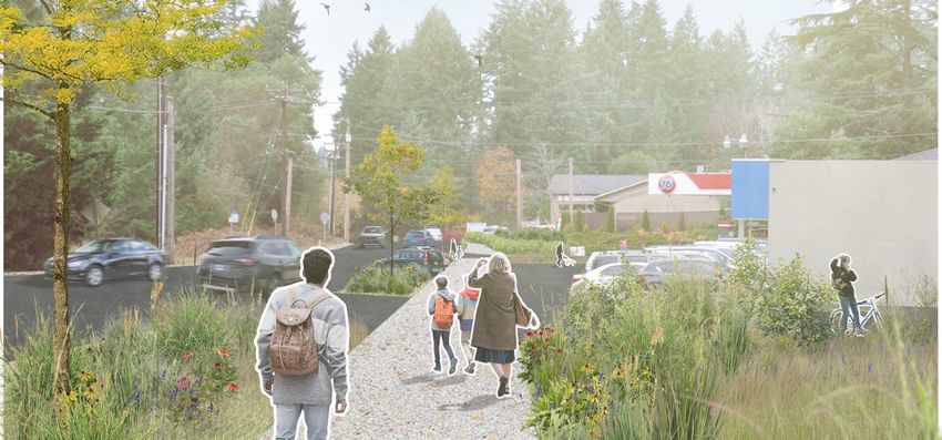
30FIGURE 18. NON-MOTORIZED TRANSPORTATION IMPROVEMENTS
Framework, 2021
31Streets Trail System
Existing streets in Island Center have With potential redevelopment of properties
limited sidewalk and pedestrian facilities, along Fletcher Bay Rd NE and Miller Rd
with relatively narrow shoulders extending NE, there is an opportunity to create a
north along Miller Rd, NE and sidewalks substantial trail network with off-road
only at the corner of Miller Rd NE, NE New pedestrian connections between properties,
Brooklyn Rd and Fletcher Bay Rd NE. One public spaces and natural areas in Island
of the priorities of this plan is to create safe, Center. A potential trailhead from Miller Rd
dedicated facilities for people walking and NE beginning at the City property south of
biking, particularly along the north-south Congregation Kol Shalom, could connect
portion Fletcher Bay Rd and Miller Rd NE Island Center Cemetery, and a potential
between Island Center Hall and the Grand viewpoint on the uphill portion of the City’s
Forest, and safer crossings at the busy property, and the rear of a long undeveloped
intersection of Miller Rd NE, NE New Brooklyn property that fronts on NE New Brooklyn
Rd and Fletcher Bay Rd NE. Figure 19 shows Rd. A trail connection to NE New Brooklyn
concept plans for potential short- and long- Road could offer a quiet, wooded route to
term improvements. The short-term concepts businesses and new development in Island
would be relatively inexpensive to implement Center separated from the busy intersection
and would allow for testing to ensure the of NE New Brooklyn Rd, Fletcher Bay Rd
concepts are effective at providing safe NE, and Miller Rd NE. Trail connections to
places to walk and bike. The long-term option surrounding properties can also offer access
would require further design and engineering between potential parking on the site and
work along with a capital investment for local businesses that is more pedestrian
implementation. friendly.
The physical conditions along the major
streets in Island Center are highly variable This trail system is primarily intended for local
and in some cases are challenging for adding access and recreation but could connect
facilities for walking and biking. To address with more the expansive trail system on the
the varying conditions several street section west side of Bainbridge Island via pedestrian
concepts were developed at the locations facilities that extend to the Grand Forest to
shown in Figure 20. Physical constraints the north and toward Gazzam Lake Nature
along with poor access management to Preserve to the south. Future development or
adjacent properties makes it difficult to add open space in the northern part of the study
dedicated sidewalks and bike facilities on area in and around the Bainbridge Gardens
both sides of the street such as on portions node could also include trails that could be
of Miller Rd NE north of NE New Brooklyn integrated into this network.
Rd and NE Fletcher Bay Rd. Therefore, a
multi-use path is proposed as one option for
addressing they physical constraints since it
allows for bi-directional travel for pedestrians
and bicyclists and is the most efficient use of
limited space. Some locations include more
than one section to show the range of options
for improvements. On-street parallel parking
is recommended as an option only in the Four
Corners node to right-of-way constraints and
physical conflicts.
32FIGURE 19. STREET IMPROVEMENT CONCEPTS – SHORT AND LONG-TERM
EXISTING STREETSCAPE - MILLER BAY ROAD
TEMPORARY / LOW COST IMPROVEMENTS - MILLER BAY ROAD
Framework, 2021
The photo above shows Miller Bay Road NE looking north near the intersection with New
Brooklyn Road. Only short sections of sidewalk exist near the intersection and driveways to
adjacent properties often span the entire frontage of the property creating potential conflicts
with pedestrians and bicycles.
Better access management could be implemented in the near term with low-cost or temporary
improvements as shown in the illustration above. If there are resources in the community for
maintenance, landscape elements such as planters may be added.
33EXISTING STREETSCAPE - FLETCHER BAY RD NE
LONG TERM IMPROVEMENTS - MILLER BAY ROAD
Framework, 2021
The existing streetscape at Fletcher Bay Rd NE near the Fletcher Bay Mart (looking north) has
clear sidewalk in and driveways to adjacent properties often span the entire frontage of the
property, creating potential conflicts with pedestrians and bicycles.
The illustration above shows a streetscape concept for Fletcher Bay Rd NE that adds a
pedestrian trail on the east side of the street and on-street parking to replace the parking on
private property that is currently in the public right-of-way. Natural landscaping and reduction in
curb cuts to minimize conflicts between pedestrians and vehicles.
34EXISTING STREETSCAPE - MILLER RD NE/NEW BROOKLYN RD/FLETCHER BAY RD NE
TEMPORARY IMPROVEMENTS - MILLER RD NE/NEW BROOKLYN RD/FLETCHER BAY RD NE
Framework, 2021
LONG TERM IMPROVEMENTS - MILLER RD NE/NEW BROOKLYN RD/FLETCHER BAY RD NE
Framework, 2021
The existing intersection at Miller Rd NE, New Brooklyn Rd, and Fletcher Bay Rd NE is the
only portion of the study area that has sidewalks, but they are inadequate in width, lack
landscape elements, and have minimal buffer from adjacent traffic. Low-cost pedestrian and
bike facilities, such as paint and barriers, can be added in the near term. The existing sidewalk
could be removed and replaced with curbless sidewalks and paths at grade with the street and
incorporated with landscape and artistic crosswalks in the long-term concept.
35FIGURE 20. STREET SECTION LOCATIONS
Framework, 2021
36FIGURE 21. STREET CONCEPT SECTION #1 - SOUTH FLETCHER BAY RD LOOKING NORTH
Framework, 2021
FIGURE 22. STREET CONCEPT SECTION #2.1 - MILLER RD/FLETCHER BAY RD LOOKING NORTH
Framework, 2021
37FIGURE 23. STREET CONCEPT SECTION #2.2 - MILLER RD / FLETCHER BAY RD LOOKING NORTH
Framework, 2021
FIGURE 24. STREET CONCEPT SECTION #3 - NEW BROOKLYN RD LOOKING EAST
Framework, 2021
38FIGURE 25. STREET CONCEPT SECTION #4.1 - FLETCHER BAY RD WESTBOUND LOOKING WEST
Framework, 2021
FIGURE 26. STREET CONCEPT SECTION #4.2 - FLETCHER BAY RD WESTBOUND LOOKING WEST
Framework, 2021
39FIGURE 27. STREET CONCEPT SECTION #5 - MILLER RD SOUTH OF DPW LOT LOOKING NORTH
Notes: Given the topography change in this potion, trees may require adjusting location for the bike lane and sidewalk.
Framework, 2021
FIGURE 28. STREET CONCEPT SECTION #6.1 - MILLER RD AT DPW LOT LOOKING NORTH
Framework, 2021
40FIGURE 29. STREET CONCEPT SECTION #6.2 - MILLER RD AT DPW LOT LOOKING NORTH
Framework, 2021
FIGURE 30. STREET CONCEPT SECTION #7 - MILLER RD NEAR BATTLE POINT DR LOOKING NORTH
Framework, 2021
41POLICIES STRATEGIES
Encourage undergrounding new and Continue to coordinate with Puget
existing franchise utilities, including Sound Energy and other utilities to
electrical transmission/distribution improve reliability of the power grid and
power, cable, telephone, and internet telecommunication systems, and integrate
lines; maximize opportunities with new undergrounding utility lines whenever
construction; and prioritize work that possible during public or private capital or
affects the greatest number of households development projects.
and businesses. Actively pursue an off-street trail network
Provide safe multi-modal transportation in Island Center in partnership with private
facilities in Island Center that property owners and conservation and
accommodate vehicles and people recreation organizations
walking and biking. Consider implementing temporary
Provide safe on- and off-street facilities for transportation improvements to enhance
walking and biking that connect all areas opportunities for walking and biking in the
within Island Center. near term while testing potential long-term
Incorporate appropriate traffic calming improvements
measures into street improvements to Further plan for street improvements in
reduce vehicle speeds and improve safety. Island Center with additional design and
Transportation improvements should be engineering work in collaboration with
subject to additional public engagement community stakeholders.
efforts during the design and engineering
process including direct outreach to
residents and property owners that
will be directly affected. Transportation
improvements should be designed to
ensure that employees and customers can
safely access Island Center businesses.
Minimize the number and size of curb
cuts along major streets in Island Center
to avoid conflicts between vehicles and
pedestrians and bicyclists.
Avoid widening streets to increase vehicle
capacity in Island Center and emphasis
local access.
42You can also read