Nisyros Volcanic Island: A Geosite through a Tailored GIS Story - MDPI
←
→
Page content transcription
If your browser does not render page correctly, please read the page content below
geosciences

Article
Nisyros Volcanic Island: A Geosite through a Tailored
GIS Story
Varvara Antoniou * , Paraskevi Nomikou                        , Dimitrios Panousis and Effrosyni Zafeirakopoulou

                                          Department of Geology and Geoenvironment, School of Science, National and Kapodistrian University of Athens,
                                          Panepistimioupoli, 15784 Zografou, Greece; evinom@geol.uoa.gr (P.N.); panousisdimitris98@gmail.com (D.P.);
                                          effie.zaf92@gmail.com (E.Z.)
                                          * Correspondence: vantoniou@geol.uoa.gr

                                          Abstract: The volcanic island of Nisyros (Greece) is here presented as it presents unique characteristics
                                          being a Quaternary volcano in the eastern Aegean Sea, composed of volcanic rocks, and featuring a
                                          central caldera that is surrounded by volcanic domes and thick lavas. Its history is strongly connected
                                          to the volcano impressing the visitors with steaming hydrothermal craters, intensive smell of sulfur
                                          and fumarolic gases, and hot springs. Due to its morphology and geographical position, its cultural
                                          and historical heritage has been unchanged in time, bequeath to the island plenty of churches,
                                          monasteries with hagiographic frescoes, castles, caves, and spas. To present the geodiversity, the
                                          cultural environment, and the biodiversity of this geosite, a relatively new geographic approach
                                          was used, ESRI Story Maps. Being web-based applications, they are widespread as an interactive
                                          responsive tool used for spatial data communication and dissemination, by combining thematic 2D
                                          and 3D webmaps, narrative text, and multimedia content. Such applications can be an ideal way for
                                          presenting the available information of places characterized as geosites or protected areas worldwide,
                                          providing quick access to the available information to a broader, non-technical audience, developing
                                          the interest, and possibly motivating the public to learn more or visit them.


                                          Keywords: Story Maps; geosite; web app
Citation: Antoniou, V.; Nomikou, P.;
Panousis, D.; Zafeirakopoulou, E.
Nisyros Volcanic Island: A Geosite
through a Tailored GIS Story.             1. Introduction
Geosciences 2021, 11, 132. https://
                                                Throughout the history of the Earth, the processes that shaped the surface of the planet
doi.org/10.3390/geosciences11030132
                                          left behind numerous geological formations that allowed not only for their understanding
                                          but also for their admiration by humanity. In that direction, the term geodiversity engulfs
Received: 25 January 2021
Accepted: 9 March 2021
                                          all the variety of evidence of the Earth’s past, including landforms, rocks, and minerals,
Published: 13 March 2021
                                          volcanoes, sediments and soils, water, and fossils, along with the dynamic processes that
                                          led to their formation and preservation on the surface of the planet. Out of those elements,
Publisher’s Note: MDPI stays neutral
                                          geoheritage accounts for the ones considered to have noteworthy scientific, educational,
with regard to jurisdictional claims in
                                          cultural, and aesthetic value [1] incarnating the link between natural phenomena and their
published maps and institutional affil-   human understanding [2,3].
iations.                                        Among these places, volcanoes undeniably play an important role as they present
                                          unique natural landscapes that provide scientists with many opportunities related to
                                          various fields of research and they are also linked to crucial resources offered to the societies
                                          living under or close to their shadows, such as geothermal and geological resources, raw
Copyright: © 2021 by the authors.
                                          materials, geotourism, fertile soils, etc. [4], that helped them flourish over the times of
Licensee MDPI, Basel, Switzerland.
                                          humanity [5].
This article is an open access article
                                                It is this destructive and productive aspect along with the extraordinary displays of
distributed under the terms and           eruptive volcanoes that capture the imagination and generate interest in the general public,
conditions of the Creative Commons        leading to a growth in popularity of geoparks that host active volcanism [1,6–10]. Hence,
Attribution (CC BY) license (https://     the development of novel and efficient ways of communicating scientific research results to
creativecommons.org/licenses/by/          the general public and disseminating information on volcanic geoheritage, volcanic hazard,
4.0/).                                    and geotourism, especially regarding remote areas with poor accessibility, is of crucial

Geosciences 2021, 11, 132. https://doi.org/10.3390/geosciences11030132                                  https://www.mdpi.com/journal/geosciences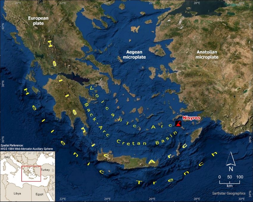
Geosciences 2021, 11, 132                                                                                            2 of 20

                            importance [1,3]. Communicating scientific results to a broad audience that includes not
                            only experts but also people with a non-scientific background can be an incredibly effective
                            way of bridging the gap between science and the public. In the field of geosciences, apart
                            from scientific papers, conferences, and general literature, one of the most important means
                            of information dissemination is through maps.
                                  Geographic Information Systems (GIS) have rapidly evolved to provide new tools
                            for spatial analytics with complex variable datasets [11]. As a result, digital maps have
                            now emerged, which are not only multimedia presentations (by using different map layers,
                            photos, videos, diagrams, sound, and music), but also serve as innovative educational
                            tools that provide users with interactive maps comprised of multimedia content and
                            informational text [12]. Interactive webmaps combine attractive map features to create a
                            visual story that can effectively communicate a message to a broad audience [13]. They are
                            ubiquitous for everyday use such as navigating geographically; however, many educational
                            institutions also take advantage of their possibilities for teaching and learning. Furthermore,
                            the versatility of digital maps has encouraged their use in private industries and businesses,
                            all levels of government, and research institutions [14].
                                  According to [15], ‘Storytelling using digital maps is an important approach to commu-
                            nicating and conceptualizing the endless accumulation of data’. It supplements interactive
                            maps by helping users to understand convoluted spatial relationships while providing
                            an exciting experience [13]. Furthermore, previous studies suggest that storytelling can
                            increase an audience’s willingness to learn and retention of material [16], while narra-
                            tive storytelling is an efficient tool to be utilized supplementary to traditional forms of
                            communication.
                                  In that direction, Story Maps, a relatively new approach, were introduced to provide
                            a powerful way to create, explain, and present people a story for a place or any subject,
                            including various aspects of it. They are not just thematic maps, but a necessary means
                            of communication. They provide an effective visualization, robust and explanatory with
                            multi-media data like photos and videos to emphasize storytelling [11].
                                  More specifically, Story Maps are web applications where multimedia data, 2D or 3D
                            webmaps, and narrative text are combined to share the final product and engage audiences
                            to interact and participate [17]. Like web applications, they are a communication tool
                            providing the ability for every user to include functions and data for a sophisticated story.
                            Since it is an open-source dynamic tool, knowledge can be shared and exchanged on any
                            topic using a variety of apps that provide different ways of interacting with maps. In other
                            words, a Story Map is a “data storytelling” or “data-driven storytelling” instrument that
                            has been used to unveil hidden information from data and to present them to every user.
                                  The purpose of this paper is to present the implementation of Story Mapping technol-
                            ogy in the development of an interactive, user-friendly platform regarding the volcanic
                            island of Nisyros, Greece (https://tinyurl.com/ycq5buvy), aiming to provide the user
                            with multi-media information regarding the geography and biodiversity of the island, the
                            main volcano-tectonic events that have shaped it over the last thousands of years, and the
                            impact of different human civilizations through time leading to the contemporary cultural
                            conditions existed today. It also includes detailed descriptions of the prevailing walking
                            trails accompanied with interactive maps, waypoints of interest, photos, and videos, thus
                            delivering an enjoyable and leisure virtual tour of the island and providing a basic plan for
                            future geologists, tourists, and nature enthusiasts to explore upon their visit.

                            2. Study Area
                                 Nisyros is part of the Dodecanese group of islands in the eastern Aegean Sea. It is
                            an active volcano that constitutes the southeastern end of the South Aegean Volcanic Arc
                            (SAVA) and is situated within an active volcanic field that generated the largest volcanic
                            eruption in the Eastern Mediterranean Sea (Kos Plateau Tuff) [18] (Figure 1).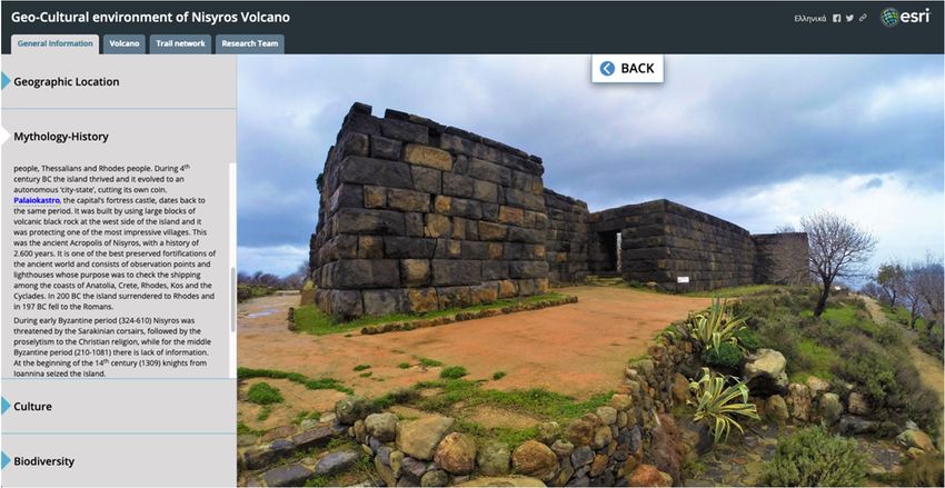
Geosciences2021,
Geosciences 2021,11,
11,132
x FOR PEER REVIEW 33 of
of 20
21
Figure1.1.AAsimplified
Figure simplifiedmap
mapshowing
showing the
the location
location of of Nisyros
Nisyros Volcano
Volcano in the
in the South
South Aegean
Aegean Vol- Arc.
Volcanic
canic Arc.
Modern-day South Aegean Volcanic Arc extends over approximately 600 km, from
Saronic Modern-day South Aegean
Gulf to the islands of Kos and Volcanic
Nisyros Arc extends
near Minorover Asia approximately
coast. It is defined 600by km,thefrom
vol-
Saronic Gulf to the islands of Kos and Nisyros near Minor
canic centers of Sousaki, Aegina, Methana, Poros, Milos-Antimilos, Santorini, Koloumbo, Asia coast. It is defined by the
volcanic
Kos, Yali, centers of Sousaki,
and Nisyros, starting Aegina,
from the Methana, Poros, Milos-Antimilos,
northwestern part down to the Santorini,
southeastern Ko-
loumbo,
part Kos, Yali,
[18] (Figure and
1). It Nisyros,
belongs starting
to the Hellenic from the northwestern
Orogenic Arc, which part downalong
is formed to the thesouth-
con-
eastern plate
vergent part [18] (Figureof1).the
boundary It belongs
northwards to the Hellenic Orogenic
subducting African plateArc, underneath
which is formed along
the active
the convergent
margin plate boundary
of the European plate. Asofa result
the northwards
of subduction subducting Africanmagmatic
and extension, plate underneath
activity
the activethroughout
occurred margin of the extensional
European plate. realmAs a result
from Middle of subduction
Eocene to Late andMiocene
extension, mag-
[19–22].
maticprecisely,
More activity occurred throughout
the subducting the plate’s
African extensional
rocksrealm
started from Middle Eocene
dehydrating during tothis
Latepro-Mi-
ocene.
cess, as [19–22].
a result of More
the precisely, the subducting
high temperatures that the African plate’s rocks
plate encounters as started
it descendsdehydrating
deeper
during
into this process, The
the Lithosphere. as amelt
result
thatofisthe high temperatures
produced from the partial thatmelting
the plate encounters
process that occurs as it
has a lowerdeeper
descends densityintothanthethe surroundingThe
Lithosphere. rocks,
meltand
thatasisa produced
result, ascends
fromtoward the surface,
the partial melting
penetrating
process thatthe overlaying
occurs Eurasian
has a lower plate
density rocks.
than the Some volumes
surrounding of this
rocks, andmeltas acrystallize
result, as-
deep
cendsbelow
toward in the
the lithosphere, and others
surface, penetrating theremain in theEurasian
overlaying liquid form plateofrocks.
magma, Somewhich rises
volumes
to the surface, thus creating volcanism. Approximately 5 million
of this melt crystallize deep below in the lithosphere, and others remain in the liquid form years ago, the spatial
distribution
of magma, which of magmatism
rises to the and volcanism
surface, thus migrated towards the
creating volcanism. south and west,
Approximately thus
5 million
leading
years ago,to thethedevelopment of the present-day
spatial distribution of magmatism situation, the South migrated
and volcanism Aegean Volcanic
towardsArc. the
Volcanic
south and activity
west, in theleading
thus SAVA started 4.7 Ma and continues
to the development up to this day
of the present-day with the
situation, theactive,
South
but dormant
Aegean volcanoes
Volcanic of Methana,
Arc. Volcanic Santorini,
activity in theKolumbo,
SAVA started and Nisyros.
4.7 Ma and continues up to
The island’s shape is almost circular, resembling
this day with the active, but dormant volcanoes of Methana, the shape of aSantorini,
cone, withKolumbo,
a total width and
of 8.5 km, a coastal circumference of about 25 km, and it covers an area of 42 km 2 (Figure 2).
Nisyros.
The surrounding
The island’sarea shapeof Nisyros
is almost consists
circular,of several
resemblingsmallerthe islands,
shape ofwhicha cone, arewith
Yali island
a total
to
width of 8.5 km, a coastal circumference of about 25 km, and it covers an areaislet
the north, Pachia and Pergoussa volcanic islets to the west, Strongyli volcanic of 42 to km
the2
northeast,
(Figure 2).and TheKondelioussa
surroundingislet areafurther
of Nisyroswest,consists
the biggest one [23,24].
of several smaller Among
islands,thewhich
peaks are of
Nisyros (the majority of which are volcanic domes), a huge collapse
Yali island to the north, Pachia and Pergoussa volcanic islets to the west, Strongyli vol- crater exists, trending
NE-SW,
canic isletwithto athelength of 2.5 and
northeast, km, Kondelioussa
a width of 1 km, and
islet an approximate
further altitude
west, the biggest one of [23,24].
100 m.
This caldera is divided into two parts: the NE one (Lakki), featuring
Among the peaks of Nisyros (the majority of which are volcanic domes), a huge collapse lush vegetation, and
the SW one (Ramos) which hosts intense steam emissions.
crater exists, trending NE-SW, with a length of 2.5 km, a width of 1 km, and an
Geosciences 2021, 11, x FOR PEER REVIEW 4 of 21
Geosciences 2021, 11, 132 approximate altitude of 100 m. This caldera is divided into two parts: the NE one (Lakki),
4 of 20
featuring lush vegetation, and the SW one (Ramos) which hosts intense steam emissions.
Figure2.2.Digital
Figure DigitalElevation
Elevation Model
Model (DEM)
(DEM) of Nisyros
of Nisyros volcanic
volcanic island.
island. MainMain localities
localities arepresented.
are also also
presented.
Nisyros is entirely composed of Quaternary volcanic rocks with a ranging compo-
sitionNisyros is entirely
from basaltic composed
andesites of Quaternary
to rhyodacites. volcanic
Geological rocks on
studies withthea island
ranging composi-
have been
tion from by
conducted basaltic
manyandesites
researchersto and
rhyodacites.
institutionsGeological
through thestudies
yearson(e.g.,
the [25–30]).
island have been
Nisyros
conducted
Volcano by many researchers
is dissected by major faultandzones
institutions
forming through thepattern
a radial years (e.g.,
around[25–30]. Nisyros
the Nisyros
Volcano[28,30–32].
caldera is dissected by major fault zones forming a radial pattern around the Nisyros
caldera [28,30–32]. significant study results of many fields of volcanology, the volcanic
By combining
historyByofcombining
Nisyros has been generally
significant assigned
study results of to five fields
many major ofepisodes [29] (Figure
volcanology, 3): In
the volcanic
the beginning,
history subaerial
of Nisyros basaltic-andesitic
has been volcanism
generally assigned determined
to five the early
major episodes [29]shield
(Figurevolcano
3): In
cycles, followedsubaerial
the beginning, by the development of a composite
basaltic-andesitic volcanism stratovolcano
determined the surrounded
early shield by several
volcano
satellite eruption centers.
cycles, followed Two major, rhyolitic
by the development plinian type,
of a composite eruptionssurrounded
stratovolcano may have followedby severala
caldera collapse, in the caldera-forming cycle, followed by the final phase
satellite eruption centers. Two major, rhyolitic plinian type, eruptions may have followed of rhyodacitic
dome effusion
a caldera that filled
collapse, in thethe western interior
caldera-forming of thefollowed
cycle, caldera. by
According
the finalto [29], of
phase therhyodacitic
five main
volcanic
dome effusion that filled the western interior of the caldera. According to [29], activity
events correspond to eruptive cycles of both mild and intense volcanic the five
that
main lasted during
volcanic longer
events or shorter
correspond to time intervals.
eruptive cyclesThe last magmatic
of both volcanic
mild and intense eruption
volcanic ac-
dates
tivityback at leastduring
that lasted 24,000longer
years,orleaving
shorter behind a hydrothermal
time intervals. The lastsystem
magmatic thatvolcanic
is still active
erup-
up to dates
tion this day.
back at least 24,000 years, leaving behind a hydrothermal system that is still
Today’s geodynamic
active up to this day. regime of Nisyros is manifested via continuous seismic tremors,
steam activity, and hydrothermal explosions. These occur due to the presence of ground-
water, which is heated by the magma stored deeply underneath. As a result, it erupts
violently at the surface (like a steaming cooking pan), forming the hydrothermal craters
that lie at the bottom of the caldera, with the most important being Stephanos, Alexander
(Flegethron), Logothetis, Mikros (Small), and Megalos (Big) Polyvotis and the Kaminakia
craters [33]. The last hydrothermal explosion occurred in 1887 [34], forming the crater of
Mikros Polyvotis. The whole system remains relatively dormant ever since, and at a state
of low risk.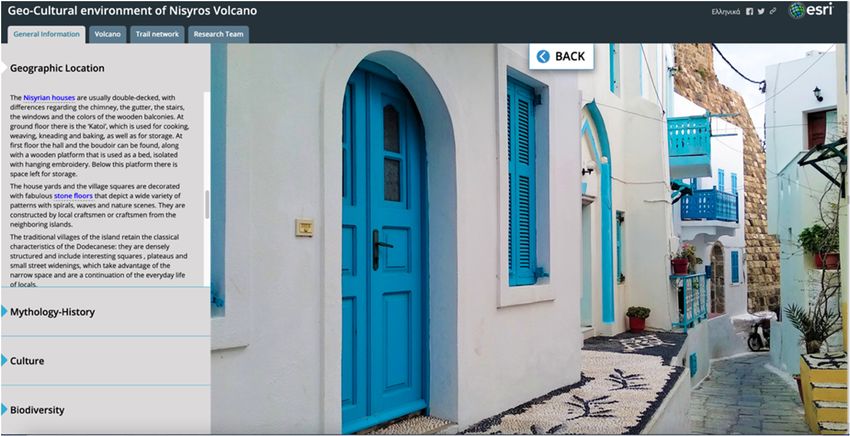
Geosciences 2021, 11, x FOR PEER REVIEW 5 of 21
Geosciences 2021, 11, 132 5 of 20
Figure
Figure 3.
3. Volcanic
Volcanic phases
phases of
of Nisyros volcanic island
Nisyros volcanic island [29].
[29].
Today’s
The abovegeodynamic
mentionedregime of Nisyros
rich volcanic is manifested
history, along with viathe
continuous
steamingseismic tremors,
hydrothermal
steam activity,
craters, and hydrothermal
the intensive smell of sulfurexplosions.
and fumarolic These occurand
gases, duehot
to springs
the presence
on theofnorthern
ground-
water,
and which shores
southern is heated by the magma
of Nisyros, as well stored
as withdeeplyits richunderneath.
human history, As asurprise
result, itthe erupts
visi-
violently
tors of theatisland
the surface (liketoaits
[29]. Due steaming
volcaniccooking
morphology pan), forming the hydrothermal
and geographical position craters
in the
southeastern
that lie at theAegean
bottom Sea,of thewhich make
caldera, it athe
with rather
most remote island,
important the cultural
being Stephanos, andAlexander
historical
heritage of Nisyros
(Flegethron), has been
Logothetis, preserved
Mikros (Small), through
and Megalostime, combining volcanological
(Big) Polyvotis and geo-
and the Kaminakia
logical
craters wonders
[33]. The with the splendor of
last hydrothermal art and civilization,
explosion occurred in 1887expressed throughthe
[34], forming prehistoric
crater of
and
Mikroshistoric locations
Polyvotis. Theand monuments,
whole system remains such asrelatively
churches, monasteries
dormant with hagiographic
ever since, and at a state
frescoes,
of low risk.castles, caves, and spas [35].
Till the
The above writing of this paper,
mentioned Nisyroshistory,
rich volcanic is accessible
along bywithferry
thefrom Kos island,
steaming where
hydrothermal
visitors can reach either by a domestic flight from Athens International
craters, the intensive smell of sulfur and fumarolic gases, and hot springs on the northern Airport (or by
international
and southernflightsshoresexecuted
of Nisyros,from someasflight
as well withcompanies directly
its rich human to Kos)
history, or bythe
surprise ship from
visitors
Piraeus Port. [29].
of the island The accommodation
Due to its volcanic is limited
morphology and the andmain means of public
geographical position transportation
in the south-
on the island,
eastern Aegean unless visitorsmake
Sea, which rent ita car, is byremote
a rather bus which hasthe
island, a relatively
cultural and limited itinerary.
historical her-
Furthermore, it is also important to mention the possibility for
itage of Nisyros has been preserved through time, combining volcanological and geolog-visitors to be accommodated
at the
ical nearby island
wonders with the of splendor
Kos, one of of art
theand
most famous touristic
civilization, destinations
expressed of Greece, and
through prehistoric and
participate in a one-day cruise to Nisyros. Nevertheless, the
historic locations and monuments, such as churches, monasteries with hagiographic current situation is constantlyfres-
shifting as Nisyros
coes, castles, caves, andtriesspas
to improve
[35]. its touristic facilities and provide more options to
its visitors,
Till theregarding
writing ofa this
widepaper,
rangeNisyros
of activities. Hence,by
is accessible theferry
existence
from Kosof anisland,
easy-to-use
where
application like the presented Story Map is once again proved
visitors can reach either by a domestic flight from Athens International Airport (or essential, because it gives
by
another option to people that find it hard to approach and stay at
international flights executed from some flight companies directly to Kos) or by ship from the island, and that is to
virtually
Piraeus Port.explore
Theand learn about it.is limited and the main means of public transportation
accommodation
onMaterials
3. the island, andunless visitors rent a car, is by bus which has a relatively limited itinerary.
Methods
Furthermore, it is also important to mention the possibility for visitors to be accommo-
To create the Story Map of Nisyros island, aiming to present the volcanic as well as the
dated at the nearby island of Kos, one of the most famous touristic destinations of Greece,
anthropogenic environment of the island, different types of datasets have been compiled
and participate in a one-day cruise to Nisyros. Nevertheless, the current situation is con-
new or existing ones, either private or from open-source portals. Moreover, multiple data
stantly shifting as Nisyros tries to improve its touristic facilities and provide more options
Geosciences 2021, 11, 132                                                                                            6 of 20

                            collection field trips have taken place, aiming to capture the exact location of each site of
                            interest along with representative photos and videos to enrich the existing geo-cultural
                            knowledge.
                                  All the available (analog or digital) information for the area (bibliography, topographic
                            map, geological structure, etc.) was collected, homogenized, organized, and lastly trans-
                            formed to WGS 1984 Web Mercator (auxiliary sphere) projected coordinate system and
                            stored in an ArcGIS Pro (https://tinyurl.com/yawowu3g) software geodatabase. ArcGIS
                            Collector (https://tinyurl.com/yzrebtwh), available both for Android and iOS devices,
                            was used to ensure the accuracy of the geographic location of collected data during field-
                            work. For that purpose, at first, a second geodatabase was created to include the two vector
                            feature classes designed for data collection: a point one, to store spatial and descriptive
                            data for each site of interest along with multimedia content and a polyline one, to track the
                            location of the existing walking trails network using GPS signal. In the next step, a webmap
                            created and shared via ArcGIS Pro, having imagery as basemap and containing the two
                            aforementioned feature classes was shared to ArcGIS Online (https://www.arcgis.com)
                            platform, while individual parameters for each of the information layers, e.g., its symbol
                            and the appearance or not of tags and pop-up menus, etc., as well as their refresh interval,
                            were defined.
                                  Many web platforms exist nowadays that allow for the development of a story-
                            telling app, each one featuring different methods of data processing and visualization
                            (e.g., thinglink (https://www.thinglink.com/), TimeMapper (http://timemapper.okfnlabs.
                            org/), Google Earth Outreach (https://www.google.com/earth/outreach/), StoryMapJ
                            (https://storymap.knightlab.com), Odyssey by CARTODB (https://cartodb.github.io/
                            odyssey.js/). Some of the available options may require third-party apps to incorporate
                            different presentation styles while others may also involve coding.
                                  However, some platforms, like ESRI’s online one, used for this volcanic geosite promo-
                            tion, offer all the tools needed to construct an efficient visualization of all the data without
                            the need for other software to achieve the desired result. Story Maps created using ERSI’s
                            platform are web-based applications that can be accessed from any online browser, without
                            the need of being downloaded, while they can be viewed on any device, being freely
                            available. Furthermore, they easily allow modifications and changes well after their initial
                            launching. Any additional information or change within the app gets immediately updated
                            after publishing the Story Map again, thus users get the most recent version automatically,
                            the next time they open the app or by reloading it.
                                  Having, also, in mind that all data mentioned before were created and already stored in
                            ESRI’s platform (desktop and online), urged us to use for the main app, one of the available,
                            open-sourced configured apps, called Story Map Series (https://tinyurl.com/yznu6klu).
                                  The Story Map Series app, part of the classic Story Maps templates accessed also
                            through a free, non-commercial ArcGIS public account, allows the presentation of the
                            available information via tabs, side accordion control, or as numbered bullets, which is
                            ideal for presenting a related set of maps showing different content for the same location as
                            well as for jumping from one set of information to another without sequence. Furthermore,
                            the app can be used and shared as provided by the platform, having the option to make
                            minor CSS code modifications, or can be downloaded through GitHub, modified, and then
                            served through a private server [36]. During the deployment of Nisyros Story Map, the
                            first approach was followed due to the lack of a private server capable of managing a large
                            number of users.
                                  Finally, via the app’s interactive builder, narrative text with images, accompanied
                            by 2D and 3D webmaps created in ArcGIS Pro according to the appropriate cartographic
                            rules [37,38] and embedded content from other web apps or Story Map templates were
                            combined in an engaging experience, as described in the following section (Figure 4).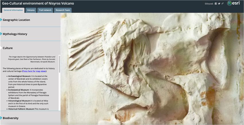
Map, the first approach was followed due to the lack of a private server capable of man-
aging a large number of users.
Finally, via the app’s interactive builder, narrative text with images, accompanied by
2D and 3D webmaps created in ArcGIS Pro according to the appropriate cartographic
Geosciences 2021, 11, 132 rules [37,38] and embedded content from other web apps or Story Map templates7 were of 20
combined in an engaging experience, as described in the following section (Figure 4).
Figure 4. Workflow used in this Story Map.
Figure 4. Workflow used in this Story Map.
4. The Story Map
4. The Story Map
The created Story Map (https://tinyurl.com/ycq5buvy) incorporates data regarding
The created
the geological and Story Map (https://tinyurl.com/ycq5buvy)
geographical incorporates
characteristics of Nisyros, its cultural heritagedataalong
regarding
with
the
its geological as
biodiversity and geographical
well as the differentcharacteristics
walking trailsof Nisyros, its cultural
that highlight all theheritage
previous along with
features
its biodiversity as well as the different
(https://tinyurl.com/ycq5buvy). walking
It offers trailsnarrative
detailed that highlight
text on allthe
theabove
previous fea-
topics
tures (https://tinyurl.com/ycq5buvy).
accompanied by 2D webmaps and 3D It offers as
scenes, detailed
well asnarrative
multimedia textcontent
on the above topics
like photos
accompanied
and by 2D webmaps
links. The thematic maps used andin3D thescenes, as well
application as multimedia
were created in ArcGIS contentPro likeand
photos
the
and links. The thematic maps used in the application were created
desired parameters regarding the level of interaction for each map, like the zoom level, in ArcGIS Pro and the
desired
the parameters
function of pop-ups,regarding
and the theinitial
level orientation
of interaction for each
of the map/scenemap, like werethedetermined
zoom level,
the function
both of pop-ups,
in the online platform and
and theStory
initial orientation
Map builder. of the map/scene
Furthermore, were determined
to present effectively both
the
in the online
available platform
information, and Story
different StoryMapMaps builder.
templatesFurthermore,
were embedded to present
in theeffectively
main one, as the
available below.
described information, different Story Maps templates were embedded in the main one, as
All thebelow.
described information was organized into four main categories covering (a) general
information
All the of the island,was
information (b)organized
geologicalinto andfourvolcanological
main categories datacovering
of the development,
(a) general in-
evolution,
formationand current
of the island, state of the volcanic
(b) geological field, (c) a detailed
and volcanological datadescription of the walking
of the development, evolu-
trails
tion, network,
and currentandstate
(d) information
of the volcanic presenting
field, (c)the researchdescription
a detailed team, that is ofthe
thescientists that
walking trails
actively
network, supported this project. presenting the research team, that is the scientists that ac-
and (d) information
tivelyUpon entering
supported thisthe interactive platform, users are asked to select between two lan-
project.
guages, Greek and English
Upon entering the interactive (Figure 5). A shortusers
platform, videoareloop plays
asked to in the background
select between twothat lan-
slowly pans around the main highlights of the island’s volcanic
guages, Greek and English (Figure 5). A short video loop plays in the background heart, taken from the topthat of
aslowly
volcanic dome within the caldera. The purpose of this video is to both
pans around the main highlights of the island’s volcanic heart, taken from the top motivate the users
toofexplore further
a volcanic domeby revealing
within thethe impressive
caldera. features from
The purpose above
of this video and to demonstrate
is to both motivate that,
the
as, during
users a possible
to explore future
further by visit to thethe
revealing island, they could
impressive easily
features fromreach beautiful
above and tovantage
demon-
points
strate with
that, splendid
as, duringviews of thefuture
a possible area, all
visitbytothemselves, on foot
the island, they could or even
easilybyreach
otherbeautiful
means
ofvantage
transportation. The Story Map cascade template was used to
points with splendid views of the area, all by themselves, on foot or even by create this part ofother
the
application.
means of transportation. The Story Map cascade template was used to create this part of
Selection of language results in a new browser tab opening that leads to the main Story
the application.
Map app, one for each language. The first view the users get is of a tabbed layout screen
having four tabs at the top, below the title of the Story Map (Figure 6). They represent the
four main categories of information on Nisyros island, with the first one regarding general
information, being active. Sections below present the information that appears in each
category.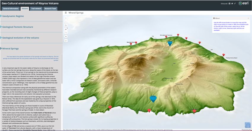
iences 2021, 11, x FOR PEER REVIEW 8 of 21
Geosciences 2021, 11, 132 8 of 20
Figure 5. Screenshot showing Story Map’s home page where the title, as well as the selection
between the languages, appear.
Selection of language results in a new browser tab opening that leads to the main
Story Map app, one for each language. The first view the users get is of a tabbed layout
screen having four tabs at the top, below the title of the Story Map (Figure 6). They repre-
sent the four main categories of information on Nisyros island, with the first one regarding
general information, being active. Sections below present the information that appears in
each category.
4.1. General Information
A side accordion layout style, which uses a horizontal, expandable panel arrange-
ment showing
Figure
Figure 5. Screenshot to present specific
5. Screenshot
Story Map’s aspects
showing Story
home of where
thehome
Map’s
page area, eachas
the page
title, with
wellits
where thenarrative
title,
as the text,
as well
selection multimedia,
as the
between selection and appear.
the languages,
between
web mapsthe languages,
or scenes, appear.
was used (Figure 6).
Selection of language results in a new browser tab opening that leads to the main
Story Map app, one for each language. The first view the users get is of a tabbed layout
screen having four tabs at the top, below the title of the Story Map (Figure 6). They repre-
sent the four main categories of information on Nisyros island, with the first one regarding
general information, being active. Sections below present the information that appears in
each category.
4.1. General Information
A side accordion layout style, which uses a horizontal, expandable panel arrange-
ment to present specific aspects of the area, each with its narrative text, multimedia, and
web maps or scenes, was used (Figure 6).
Figure 6.showing
Figure 6. Screenshot Screenshot
theshowing
main parttheofmain
the part
app of theappears
that app thatonce
appears once a language
a language is selected,
is selected, featuring four main
featuring
tabs-pages, each one of four
whichmain tabs-pages,
includes each one
additional of which organized
information includes additional information
within vertical organized
tabs. The first one, regarding
within vertical tabs. The first one, regarding general information, is active.
general information, is active.
The narration starts with a presentation of the location of Nisyros within the Aegean
4.1. General Information
Sea, the main morphological and volcanological features of the island such as the peaks,
A sideand
the caldera, the domes, accordion layout style,craters,
the hydrothermal which as
uses a horizontal,
well expandable
as brief touristic panel arrangement
information.
to present specific aspects of the area, each with its narrative text, multimedia, and web
maps or scenes, was used (Figure 6).
The narration starts with a presentation of the location of Nisyros within the Aegean
Sea, the main morphological and volcanological features of the island such as the peaks,
the caldera, the domes, and the hydrothermal craters, as well as brief touristic information.
It is enhanced with the use of an image featuring a detailed Digital Elevation Model (DEM)
Figure 6. Screenshot
derived showing
from the
themain part of theofapp
digitization that appearsdata
topographic once from
a language
mapsisofselected,
scale 1:5000, as part of
featuring four the
main tabs-pages, each one of which includes additional information organized
[39]. On this model, users can initially identify all of the key geomorphological features
within vertical tabs. The first one, regarding general information, is active.
of the island. Afterwards, it proceeds into presenting the most noteworthy architectural
traits that reflect the island’s traditions and cultural heritage. The area to the right of the
The narration starts with a presentation of the location of Nisyros within the Aegean
main text, the main stage, is used to enhance the narration either with interactive scenes or
Sea, the main morphological and volcanological features of the island such as the peaks,
with representative photos, as shown in Figure 7. Users can select the highlighted words
the caldera, the domes, and the hydrothermal craters, as well as brief touristic information.
traits that reflect the island’s traditions and cultural heritage. The area to the right of the
main text, the main stage, is used to enhance the narration either with interactive scenes
or with representative photos, as shown in Figure 7. Users can select the highlighted
words throughout the narration to change the main stage content.
Geosciences 2021, 11, 132 Within the narrative text, separated words or phrases were used to assign internal 9 of 20
links, the use of which replaces the interactive webmap either by high-resolution repre-
sentative photos showing aspects of the Nisyros anthropogenic environment or by a web
throughout
scene, that takes the narration
the viewer to change
into a virtual the
tour of main
the stage
main content.
villages of Nisyros.
Figureshowing
Figure 7. Screenshot 7. Screenshot showing
the “stone the “stone
floors”, floors”,
a typical a typical characteristic
characteristic of Nisyros’s architec-
of Nisyros’s architecture. Users can select the
ture. Users can select the highlighted words in the accompanying narration to change the main
highlighted words in the accompanying narration to change the main stage content.
stage content.
Within the narrative text, separated words or phrases were used to assign internal links,
The second
the usehorizontal
of which tab presents
replaces informationwebmap
the interactive about the mythology
either and historyrepresentative
by high-resolution of
the island. photos
It incorporates photos accessed through internal links, reflecting the island’s
showing aspects of the Nisyros anthropogenic environment or by a web scene, that
past (Figuretakes
8). The
thenarrative textadiscusses
viewer into theof
virtual tour myth behind
the main the formation
villages of Nisyros that
of Nisyros.
was conceptualized based on Gigantomachy’s descriptions of Apollodorus.
The second horizontal tab presents information about the mythology Furthermore,and history of
it presents the
the island.
users with
It incorporates photos accessed through internal links,the
all the possible scenarios regarding the origin of island’sthe island’s
reflecting
name alongpast
with(Figure
its different
8). Thevariations
narrative through time, the
text discusses leading
mythtobehind
the history of the island
the formation of Nisyros that
from prehistoric times, throughout
was conceptualized basedthe
onmedieval era, until
Gigantomachy’s recent days.
descriptions of Apollodorus. Furthermore, it
presents the users with all the possible scenarios regarding the origin of the island’s name
Geosciences 2021, 11, x FOR PEER REVIEW
along with its different variations through time, leading to the history of the island10from of 21
prehistoric times, throughout the medieval era, until recent days.
Figure 8. Screenshot
Figure 8. Screenshot showing
showing the
thesecond
secondhorizontal
horizontaltab
tabofofthe
thegeneral
general information
information category,
category, where
where the photo of Palaiokastro, one of the most outstanding archaeological monuments
the photo of Palaiokastro, one of the most outstanding archaeological monuments of Nisyros, of has
Nisyros, has been accessed.
been accessed.
Thethird
The thirdofofthe
thehorizontal
horizontaltabs
tabsincludes
includesallall
thethe places
places that
that feature
feature thethe cultural
cultural herit-
heritage
age
of of island,
the the island,
thusthus motivating
motivating users
users to visit
to visit themselves
themselves (Figure
(Figure 9).9).ItItpresents
presentsall
allthe
the
museums, churches, chapels, and monasteries of Nisyros, along with their geographical
locations that are depicted on two different interactive web scenes, accessed through nar-
ration. The first one shows the location of the museums and archaeological sites and the
second one, the location of churches, chapels, and monasteries.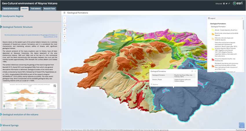
Figure 8. Screenshot showing the second horizontal tab of the general information category,
where the photo of Palaiokastro, one of the most outstanding archaeological monuments of
Nisyros, has been accessed.
Geosciences 2021, 11, 132 10 of 20
The third of the horizontal tabs includes all the places that feature the cultural herit-
age of the island, thus motivating users to visit themselves (Figure 9). It presents all the
museums,
museums, churches,
churches, chapels,
chapels, and
and monasteries
monasteries of of Nisyros,
Nisyros,along
alongwith
withtheir
theirgeographical
geographical
locations that are
locations that are depicted
depictedon ontwo
twodifferent
different interactive
interactive webweb scenes,
scenes, accessed
accessed through
through nar-
narration.
ration. TheThe
firstfirst
oneone shows
shows thethe location
location of the
of the museums
museums andand archaeological
archaeological sites
sites andand
the
the second one, the location of churches, chapels, and monasteries.
second one, the location of churches, chapels, and monasteries.
Figure 9. Screenshot
Figure 9. Screenshot showing
showingpart
partofofthe
the narration
narration about
about thethe cultural
cultural heritage
heritage ofisland
of the the island
accompa-
accompanied
nied by a photo depicting the Gigantomachy between Poseidon and Polyvotis giant. giant.
by a photo depicting the Gigantomachy between Poseidon and Polyvotis
Finally, the
Finally, the fourth and
andlast
lasttab
tabononNisyros’
Nisyros’general
generalinformation
information pagepageis all
is about bio-
all about
diversity (Figure 10). Following a brief introduction regarding the importance
biodiversity (Figure 10). Following a brief introduction regarding the importance and and recog-
nition of theofisland
recognition as a place
the island as a of significant
place naturalnatural
of significant beauty,beauty,
the narrative text is divided
the narrative text is
into twointo
divided sections; Flora, which
two sections; Flora, describes some unique
which describes speciesspecies
some unique of flowers, trees, trees,
of flowers, and vege-
and
tation in general,
vegetation andand
in general, Fauna, which
Fauna, presents
which users
presents with
users thethe
with wildlife that
wildlife thrive
that thrivein in
thethe
is-
Geosciences 2021, 11, x FOR PEER REVIEW
land. Again,
island. Again,throughout
throughoutthethedescriptions,
descriptions,users
users will
will find
find a great number of representative 11 of 21
representative
photosthat
photos thatenhance
enhancetheir
theirexperience
experienceby bybringing
bringingwords
wordsinto
intolife.
life.
Figure
Figure 10.
10. Screenshot
Screenshot showing part of
showing part of the
the narration
narrationabout
aboutbiodiversity
biodiversityfound
foundon
onthe
theisland
islandaccompa-
ac-
companied by high-resolution
nied by high-resolution photos.photos.
4.2.
4.2. Volcano
Volcano
The
The second
second tab
tab at
at the
the top
top menu,
menu, named
named ‘Volcano’,
‘Volcano’,focuses
focuseson
onthe
thegeology
geologyof ofNisyros
Nisyros
as
as an active volcano, as well as the general geotectonic environment that it of.
an active volcano, as well as the general geotectonic environment that it is part Again,
is part of.
the sidethe
Again, accordion layout style
side accordion layoutwas used
style wastoused
organize the available
to organize information
the available into four
information into
main horizontal
four main panels.
horizontal panels.
The first horizontal expandable panel describes the geodynamic regime of Nisyros
by presenting the geometry and tectonic characteristics of the Hellenic subduction zone
and the processes that lead to volcanism in the broader area (Figure 11). Descriptive text
goes on to present the history of the South Aegean Volcanic Arc, with its north to south
migration, while it is enhanced by an explanatory map that helps users to understand thecompanied by high-resolution photos.
4.2. Volcano
The second tab at the top menu, named ‘Volcano’, focuses on the geology of Nisyros
as
Geosciences 2021, 11, 132an active volcano, as well as the general geotectonic environment that it is part of. 11 of 20
Again, the side accordion layout style was used to organize the available information into
four main horizontal panels.
The firstexpandable
The first horizontal horizontal panel
expandable panel
describes thedescribes
geodynamicthe geodynamic regime of Nisyros
regime of Nisyros
by presentingbythepresenting
geometrythe andgeometry
tectonic and tectonic characteristics
characteristics of the Hellenic of the Helleniczone
subduction subduction zone
and the
and the processes processes
that that lead to
lead to volcanism involcanism
the broader in area
the broader
(Figure area (Figure 11). text
11). Descriptive Descriptive text
goes on
goes on to present thetohistory
presentofthethehistory
South of the South
Aegean Aegean
Volcanic Arc,Volcanic
with its Arc,
northwith its north to south
to south
migration,
migration, while while itby
it is enhanced is enhanced
an explanatoryby an map
explanatory
that helpsmap thattohelps
users users tothe
understand understand the
space and time scale of this lithospheric event over the last 55 million years [40]. It finally[40]. It finally
space and time scale of this lithospheric event over the last 55 million years
gives users agives
glance users
intoatheglance
study into the study
area’s area’s geomorphological
geomorphological and tectonic and tectonic characteristics.
characteristics.
The narrative text is accompanied by an illustration of the
The narrative text is accompanied by an illustration of the orogenic arc as a cross-section,orogenic arc as a cross-section,
featuring thefeaturing
location of the location
the of theand
study area, study area, and topographic—bathymetric
a composite a composite topographic—bathymetric
map map
that shows thethat shows the
location location
of all of all the
the volcanic volcanic
centers centers
along the along theAn
arc [18]. arc interactive
[18]. An interactive
web web map
accompanies
map accompanies the narration,
the narration, featuring featuring the volcanic
the volcanic centers
centers along along
the the Volcanic
Volcanic Arc pro-Arc projected
on a high-resolution satellite
jected on a high-resolution satellite basemap. basemap.
Figure 11.showing
Figure 11. Screenshot Screenshot
partshowing part of about
of the narration the narration about theregime
the geodynamic geodynamic regime
of the island of the islandby the webmap
accompanied
accompanied by the webmap featuring the location of all volcanic
featuring the location of all volcanic islands across the Hellenic Volcanic Arc. islands across the Hellenic
Volcanic Arc.
The second horizontal tab summarizes information regarding the volcano on a litho-
spheric scale and describes the two categories of fault systems that crosscut the island
(Figure 12). It also features the earliest studies that have been conducted on the area, lead-
ing up to the most recent and detailed field mapping work of [29]. Apart from narrative
text, users will also find an image with two representative cross-sections of the island as
well as a detailed tectonic map of the fault zones of Nisyros [23,25–32,34,39,41–46]. The
most prominent, however, feature of this tab is the interactive 3D web scene to the right,
which depicts the spatial distribution of the geological formations of Nisyros. Users can
use both the left and right buttons on the mouse to move the map and rotate it respectively.
With the available tools on the left side of the scene, they can select the desired focus,
change zoom levels or reverse to the initial predefined position. At the bottom right of
the screen, different basemap styles can be selected with the click of a button, while by
selecting a formation, a pop-up provides further information. By expanding the menu
located to the left of the web scene title, the entire legend can be triggered and displayed
to the right side of the screen. This web scene gives a unique opportunity to discover the
traces of the island’s volcanic past layer by layer and to admire the complexity of fieldwork
that needs to be undertaken in areas like this, to produce highly detailed geological maps
of volcanic regions.selecting a formation, a pop-up provides further information. By expanding the menu lo-
cated to the left of the web scene title, the entire legend can be triggered and displayed to
the right side of the screen. This web scene gives a unique opportunity to discover the
traces of the island’s volcanic past layer by layer and to admire the complexity of field-
work that needs to be undertaken in areas like this, to produce highly detailed geological
Geosciences 2021, 11, 132 12 of 20
maps of volcanic regions.
Figure 12.showing
Figure 12. Screenshot Screenshot
partshowing part of the
of the narration narration
about about the geological–tectonic
the geological–tectonic structure of thestructure of
island accompanied by a
the island accompanied by a 3D interactive web scene featuring the spatial distribution of the
3D interactive web scene featuring the spatial distribution of the geological formations. Users can select a formation to get
geological formations. Users can select a formation to get further information.
further information.
The third horizontal
The third tabhorizontal
presents the
tab evolution
presents the of the volcanoofthrough
evolution time,through
the volcano by de- time, by de-
scribing the five major volcanic phases that have taken place to form the island (Figure
scribing the five major volcanic phases that have taken place to form the island (Figure 13).
13). Apart from narrative
Apart text, an image
from narrative with
text, an schematic
image depictionsdepictions
with schematic of the different
of thestages
different stages of
of evolution is presented. To the right, users can visualize the different eruptive
evolution is presented. To the right, users can visualize the different eruptive events events that
that gave Nisyros its present-day
gave Nisyros morphological
its present-day shape,shape,
morphological by activating the player
by activating or by
the player or by manually
manually advancing
advancing time
timeforforthe
the different volcanicformations
different volcanic formationscorresponding
corresponding to to
eacheach
phase to appear
phase to appear
on on
thethe map.
map. ThisThis demonstration
demonstration of the
of the evolution
evolution of the
of the volcano
volcano is aisunique
a uniquecapability of the
capability of the Story Mapping platform, as it has the potential to actively
Story Mapping platform, as it has the potential to actively engage audiencesengage audi-and help them
ences and help them understand
understand complex complex
mechanismsmechanisms that originally
that originally require scientific
require scientific lectures or even field
lectures or even
ciences 2021, 11, x FOR PEER REVIEW tripsfield tripsenvisage
to fully to fully envisage and an
and can have canimmensely
have an immensely positive
positive impact on impact
13 of 21
promoting volcanic
on promotinggeoheritage
volcanic geoheritage
around thearound
world.the world.
Figure 13. Screenshot showing part of the narration about the geological evolution of the vol-
Figure 13. Screenshot showing part of the narration about the geological evolution of the volcano accompanied by a 2D
cano accompanied by a 2D webmap featuring the spatial distribution of the different eruptive
webmap featuring the spatial distribution of the different eruptive phases that led to the island’s present-day morphological
phases that led to the island’s present-day morphological shape. Users can activate the player,
shape. Users or
canthey
activate the player,
can manually or theytime
advance can manually advance
for the different time forformations
volcanic the different volcaniconformations
to appear the map. to appear on
the map.
The last horizontal tab focuses on the current state of the volcano and a characteristic
for which is mostly known since antiquity: mineral springs (Figure 14). It describes some
basic physical and chemical characteristics of both onshore and offshore thermal water
manifestations along with information on their use since ancient times. It then gives de-
tails of the most prominent springs of the island, along with a representative photo of an
underwater spring that can attract divers to explore further. The interactive 3D web sceneFigure 13. Screenshot showing part of the narration about the geological evolution of the vol-
cano accompanied by a 2D webmap featuring the spatial distribution of the different eruptive
Geosciences 2021, 11, 132 that led to the island’s present-day morphological shape. Users can activate the player,
phases 13 of 20
or they can manually advance time for the different volcanic formations to appear on the map.
The last
The last horizontal tab horizontal
focuses on tab the focuses
current on theofcurrent
state state of
the volcano andthea volcano and a characteristic
characteristic
for which
for which is mostly known is mostly known since
since antiquity: antiquity:
mineral springsmineral
(Figuresprings (Figure 14).
14). It describes It describes some
some
basic physical basic physical characteristics
and chemical and chemical characteristics
of both onshore of and
bothoffshore
onshorethermal
and offshore
waterthermal water
manifestationsmanifestations along with
along with information on information
their use sinceon ancient
their use sinceIt ancient
times. times.
then gives de- It then gives
details of the most prominent springs of the island, along
tails of the most prominent springs of the island, along with a representative photo of an with a representative photo of
an underwater spring that can attract divers to explore further.
underwater spring that can attract divers to explore further. The interactive 3D web scene The interactive 3D web
scene to the right specifies the location for both hot springs
to the right specifies the location for both hot springs and hot steam emissions. An infobox and hot steam emissions. An
infobox at the upper right corner of every scene in the Story
at the upper right corner of every scene in the Story Map guides the users on how to in- Map guides the users on how
to interact
teract with it, thus allowing withforit,maximizing
thus allowing thefor maximizing the experience.
experience.
Figure 14. Screenshot
Figure 14. Screenshot showing
showing part of the part of theabout
narration narration about the
the mineral mineral
springs springs
locates locates
on the onaccompanied
island the by an
interactive island
3D web accompanied by an
scene featuring theinteractive 3Dboth
location for webhot
scene featuring
springs the location
(red circles) forsteam
and hot both hot springs(blue marks).
emissions
(red circles) and hot steam emissions (blue marks).
es 2021, 11, x FOR PEER REVIEW 4.3. Trail Network 14 of 21
4.3. Trail Network
The third tab at the top of the screen is the presentation of the trail network of the
The third island.
tab at the
Tentop of the routes
touristic screen were
is theproposed
presentation
and of the trail network
described, that takeof the into a virtual
users
island. Ten touristictrip
routes were proposedgives
and them
described,
first that take users into the
a virtual
field trip across field
Nisyros andacross Nisyros
gives them and
a first chance ofaadmiringchance
the of admiring
natural natural and cultural
and cultural
heritage
heritage of the place of the
(Figure place (Figure 15).
15).
Figure
Figure 15. Screenshot
15. Screenshot showing
showing the spatial
the spatial distribution
distribution of theof thenetwork
trail trail network proposed
proposed and de- in this app.
and described
scribed in this app.
Story Map Cascade template was chosen to present each of the nine trails along with
the circumnavigation of the island. A general description of the sights that can be viewed
is given accompanied by a web app, created using Web AppBuilder, where an interactive
2D map shows the trace of the route (Figure 16a). Users, activating the ‘Explore’ button atFigure 15. Screenshot showing the spatial distribution of the trail network proposed and de-
scribed
Geosciences 2021, 11, 132 in this app. 14 of 20
Story Map Cascade template was chosen to present each of the nine trails along with
the circumnavigation of the
Story Map island. A general
Cascade templatedescription
was chosen of the sights that
to present eachcan be viewed
of the nine trails along with
is given accompanied by a web app, created using Web AppBuilder, where an interactive
the circumnavigation of the island. A general description of the sights that can be viewed is
2D map showsgiven
the trace of the route
accompanied by(Figure 16a).created
a web app, Users, activating
using Web the ‘Explore’ where
AppBuilder, buttonan at interactive 2D
the bottom right
map corner
shows ofthe
thetrace
screen, canroute
of the hover their 16a).
(Figure mouse on the
Users, map to the
activating reveal geo- button at the
‘Explore’
graphic coordinates
bottomofright
a point of interest
corner or when
of the screen, canthey
hoveraretheir
infield,
mousetheyoncan
theuse
map the
to‘My
reveal geographic
Location’ button to see their
coordinates oflocation
a point ofoninterest
the map.orFollowing
when theythisaregeneral
infield,section,
they canusing an ‘My Location’
use the
embedded Story MaptoTour
button template,
see their a more
location on thedetailed tour of several
map. Following selected
this general points
section, of an embedded
using
interest can beStory
foundMap (Figure
Tour16b). Once aexploration
template, more detailedis activated, users selected
tour of several can select a num-
points of interest can be
bered point onfound
the web map16b).
(Figure to seeOnce
eachexploration
specific point of interest’s
is activated, description
users can select aand navi- point on the
numbered
gate around thewebareamap to see eachbetween
transitioning specific point
variousof interest’s description
points without and navigate
sequence. Imagery is around the area
transitioning
used as a basemap to revealbetween various points
the topography of thewithout sequence.
area. Users Imagery
have also is used to
the option as a basemap to
follow a guidedreveal the topography
narration of the route,of the area. Users
following have also the
the numbered option
order, to follow
using a guided narration
the arrows
of the
in the description route, following the numbered order, using the arrows in the description section.
section.
nces 2021, 11, x FOR PEER REVIEW 15 of 21
(a)
(b)
Figure 16. Screenshots showing the two ways of presenting each trail, general information (a)
Screenshots
Figure 16. and showing
information the point
for each two ways of presenting
of interest (b). each trail, general information (a) and information for each
point of interest (b).
Navigating the proposed routes virtually with the Story Map provides a strong base
Navigating the proposed routes virtually with the Story Map provides a strong base
for real-world exploration during a possible future visit, by combining the simplicity of
for real-world exploration during a possible future visit, by combining the simplicity of
narration with the detailed mapping, the representative photos/videos and description of
each trail, and the general ease of use regarding the application. Figure 17 consists of rep-
resentative photos for each trail, available in the Story Map, for which a brief description
is as follows.You can also read