Forgotten Nazi Forced Labour Camps: Arbeitslager Riese (Lower Silesia, SE Poland) and the Use of Archival Aerial Photography and Contemporary ...
←
→
Page content transcription
If your browser does not render page correctly, please read the page content below
remote sensing
Article
Forgotten Nazi Forced Labour Camps: Arbeitslager
Riese (Lower Silesia, SE Poland) and the Use of
Archival Aerial Photography and Contemporary
LiDAR and Ground Truth Data to Identify and
Delineate Camp Areas
Aleksander Kamola 1 , Sebastian Różycki 2, * , Paweł Bylina 2 , Piotr Lewandowski 3 and
Adam Burakowski 4
 1    Head Office of Geodesy and Cartography, 2 Wspólna str., 00-926 Warsaw, Poland; awk10@onet.pl
 2    Faculty of Geodesy and Cartography, Warsaw University of Technology, 1 Sq. Politechniki, 00-661 Warsaw,
      Poland; pawel.bylina@pw.edu.pl
 3    Foundation Thesaurus, 18 Warpnowska str., 60-453 Poznań, Poland; fundacja_thesaurus@yahoo.com
 4    Central Administration, Warsaw University of Technology, 18/20 Noakowski str. 18/20, 00-668 Warsaw,
      Poland; adam.burakowski@pw.edu.pl
 *    Correspondence: sebastian.rozycki@pw.edu.pl; Tel.: +48-234-73-58

 Received: 30 April 2020; Accepted: 26 May 2020; Published: 3 June 2020

 Abstract: The “Riese” project was a huge construction project initiated by German Nazi authorities,
 which was located in the northeast of the Sowie Mountains (Ger. Eulengebirge) in southwestern Poland.
 Construction of the “Riese” complex took place in 1943–1945 but was left unfinished. Due to the lack
 of reliable sources, the exact intended function of the Riese complex is still unknown. The construction
 was carried out by prisoners, mostly Jews, from the main nearby concentration camps, KL Gross-Rosen
 and KL Auschwitz-Birkenau. Thanks to the discovery in the National Archives (NARA, USA) of
 a valuable series of German aerial photographs taken in February 1945, insight into the location of
 labour camps was obtained. These photographs, combined with LiDAR data from the Head Office
 of Geodesy and Cartography (Warsaw, Poland), allowed for the effective identification and field
 inspection of the camps’ remains. The location and delimitation of the selected labour camps were
 confirmed by an analysis of the 1945 aerial photograph combined with LiDAR data. These results
 were supported by field inspection as well as archival testimonies of witnesses. The field inspection
 of the construction remains indicated intentionally faulty construction works, which deliberately
 reduced the durability of the buildings and made them easy to demolish. The authors believe that
 it is urgent to continue the research and share the results with both the scientific community and
 the local community. The authors also want to emphasize that this less-known aspect of Holocaust
 history is gradually disappearing in social and institutional memory and is losing to the commercial
 mythologization of the Riese object.

 Keywords: concentration and labour camps; taboo heritage; archival aerial photography; LiDAR; GIS

1. Introduction
      German Nazi concentration camps were a place of death and suffering for thousands of innocent
victims of World War II. The significance of commemorating these facilities is emphasized by the
fact that, for example, Auschwitz-Birkenau Concentration Camp is on the UNESCO World Heritage
Site list [1]. It has been 75 years since the end of the War. New diagnostic techniques are being
employed with increased frequency and archives have been made more accessible. Both of these facts

Remote Sens. 2020, 12, 1802; doi:10.3390/rs12111802                        www.mdpi.com/journal/remotesensing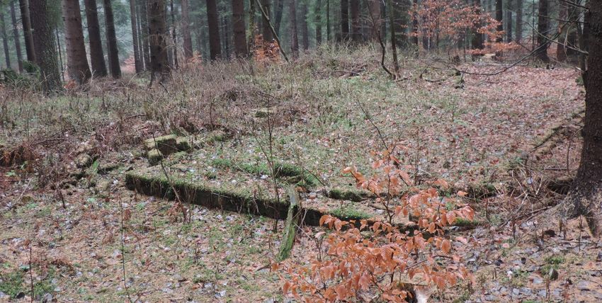
Remote Sens. 2020, 12, 1802                                                                           2 of 21

have contributed to turning a new page when it comes to researching the history of concentration,
labour, penal and death camps from World War II [2–4]. It has to be emphasized that the collective
memory related to some of those camps is fading away [5], especially if they were never entered into a
commemoration framework (such is very often the case with smaller subcamps or camp branches).
A lack of legal regulations together with convoluted issues related to ownership of the land only serve
to exacerbate the difficulties encountered while trying to commemorate those facilities.
       In the last few years, many research papers have been written on the topic of investigating the
camps from the time of World War II [5–9]. This is due to the increasing number of interdisciplinary
research teams that are being established, and to the explosive growth of digital technologies [10,11].
It is no wonder, however, that many camps have become forgotten over time. Such is currently the case
in southwestern Poland, where smaller auxiliary camps created in World War II that operated within
the structure of the Gross-Rosen Concentration Camp are now disappearing from the mental map.
This paper is the first attempt to locate the five auxiliary camps that together formed Arbeitslager Riese
(AL Riese) and to evaluate the level of their preservation using multisource spatial data and witness
testimonies. Some of the analysed areas are difficult to reach as they are located in a mountainous
region and have since been reclaimed by nature [12]. In other cases, the areas are not available
anymore as they were sold and are now private property. Only a handful of such facilities are even
marked with a commemorative plaque. Very often, the local government authorities find it difficult to
mark such places in their spatial development plans. This type of problem is not unique to Poland,
however [13,14].
       The following article also explores the concept of taboo heritage as a way to describe a legacy of war
so sensitive that the process of heritage creation has never properly begun. There are a number of threats
to cultural heritage sites [15]. They can be damaged by natural disasters [16–18] and human activity [19],
but the passage of time, the conscious or unconscious repudiation of history and memory, and the
obstruction of historical or archaeological activities by the local government all play an important role.
It is important to initiate a complex academic analysis of those areas because of a currently ongoing
investigation by the Institute of National Remembrance of the war crimes committed in the Gross-Rosen
concentration camp and its auxiliary camps (including Arbeitslager Riese). Moreover, we should
attempt to commemorate and mark those places of memory in an appropriate way [20].

2. Historical Background
      The Riese (the German word for “giant”) project was a construction enterprise of Nazi Germany,
located in the Owl Mountains (Góry Sowie) range. The construction of the “Giant” took place between
1943 and 1945, but it was never finished [21]. Today we are not even certain of the exact function that
the Riese complex was supposed to have. Some existing documents and testimonies point toward the
interpretation that the Owl Mountains and the Ksia˛ż castle (Schloss Fürstenstein in German) were
supposed to become the Führerhauptquartiere “Riese/Rüdiger”, meaning they were supposed to be
the central headquarters of Adolf Hitler himself, in addition to housing the central headquarters
of various elements of the German Army (Wehrmacht) [22]. Some other interpretations lead us to
believe that the “Giant” was supposed to be an air-raid shelter for war purposes. Many different
factories engaged in the war effort were relocated to the complex, most of them producing equipment
for the Luftwaffe (German Air Force). It is also likely that V1 and V2 rocket production took place
there [23]. Moreover, there are rumours that Germans brought to the Riese many of the items that
they looted. The area of the Sudeten was fairly safe for Germans, so the complex was considered
to be secure from Allied air strikes. The plan envisioned the creation of six facilities in the Owl
Mountains area, each of them consisting of an aboveground and an underground part, together with
all the necessary infrastructure [24]. The Germans constructed many buildings from steel-reinforced
concrete and nested them into the slopes of the mountains. Some of them were of a technical nature,
some were offices, and others were living quarters. The slopes of the mountains were mined and
tunnels were dug that led to the main excavation chambers. It was in those chambers, after they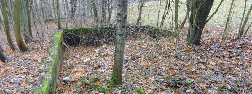
Remote Sens. 2020, 12, 1802                                                                      3 of 21

had been made impenetrable by steel-reinforced concrete, that even more office and living spaces
were supposed to be located. The construction was carried out by slave laborers coming from the
“Konzentrationslager Gross-Rosen” concentration camp [25]. Moreover, the “Giant” was also the
location of an auxiliary camp called “Arbeitslager Riese.” According to German documentation, up to
30,000 prisoners participated in the construction of the camp, but confirmed numbers point to only
12,000 or so inmates being present. The sheer size of the construction enterprise, as well as the
geographic spaciousness of the area it was located in, made it a necessity to create not one, but a
whole network of around a dozen or so smaller camps, called Außenlager in German. Their names
were taken from the German names of nearby villages or other geographic features: Wolfsberg,
Lärche, Kaltwaser, Eule, Falkenberg, Dörnhau, Wüstewaltersdorf, Wüstegiersdorf (the main camp
and command office), Ober Wüstegiersdorf, Wüstegiersdorf Bahnhof, Erlenbusch, Schötterwerk,
Tannhausen, Fürstenstein, Märzbachtal, Hausdorf, and Säuferwasser [26]. These camps together
constituted AL Riese. However, multiple POW camps and forced labour camps were also located in
the same region. They never had a name or number assigned to them, and were acting on an ad hoc
basis. Throughout the course of Communist rule in Poland (1945–1990), evidence of this particular
crime faded away. The barracks were stripped for parts, the construction materials and machines were
moved away, and the prisoners were scattered around the globe. No one has ever investigated the
atrocities that took place in the Riese complex in a comprehensive manner. The Main Committee for the
Investigation of Nazi War Crimes in Poland did, in fact, conduct investigations in the 1960s and 1970s,
but no conclusions were reached and the entire issue remained unclear [27]. Separate investigations
were also conducted in the 1960s–1980s by the Central Office of the State Justice Administrations for
the Investigation of National Socialist Crimes located in Ludwigsburg in Germany (Zentrale Stelle
der Landesjustizverwaltungen zur Aufklärung nationalsozialistischer Verbrechen), but it was not able
to produce any meaningful results either. This reminds us of contemporary situations where local
authorities of the British Channel Islands of Jersey and Alderney [15] or those living near Berlin [14]
have expressed a lack of interest in any archaeological investigations being carried out in their area.
     Additionally, between the 1980s and 1990s, the Walim and Głuszyca municipalities sold some
of the plots that constituted AL Riese. Between 2015 and 2019, the authorities granted permission to
construct buildings on the plots, and that process is currently ongoing. That is why establishing the
exact borders of the camps, their thorough analysis, and proper commemoration are so important.

3. Materials and Methods

3.1. Study Area
     The area in question is situated in Central Sudetes (Figure 1), which constitutes the northern
part of the Bohemian massif. The area is on the border between two physiographical units,
the Nowa Ruda Depression and the Owl Mountains (Góry Sowie in Polish or Eulengebirge in
German). The mountainous part is called the Włodarz massif and consists of five peaks: Włodarz
(Ger. Wolfsberg), Soboń (Ger. Ramenberg), Moszna (Ger. Mulenberg), Osówka (Ger. Säuferhöhen),
and Ostra (Ger. Spitzenberg). This massif, as well as other parts of the Owl Mountains, is mainly
composed of migmatites and gneisses of Cadomian origin [28]. The area to be investigated encompasses
four Gross-Rosen auxiliary camps and auxiliary camp where forced laborers working for the local
Friedrich Krupp AG branch were held. The exact borders and locations of the chosen spots have
not been established with complete certainty until now. Immediate identification and confirmation
are required.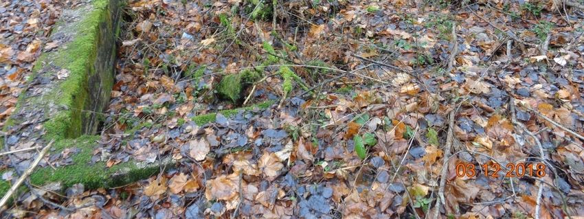
Remote Sens. 2020, 12, 1802                                                                              4 of 21
Remote Sens. 2020, 12, x FOR PEER REVIEW                                                                 4 of 21

      Figure 1.
      Figure    Study Area:
             1. Study Area: (a)
                             (a) overview
                                 overview map
                                            map with
                                                with the
                                                      the marked
                                                          marked location
                                                                 location (red
                                                                          (red point)
                                                                               point) (b)
                                                                                      (b) and
                                                                                          and map
                                                                                              map with
                                                                                                  with the
                                                                                                       the
      former camps selected for the study. Coordinate grid: UTM Zone 34 N (EPSG: 32634).
      former camps selected for the study. Coordinate grid: UTM Zone 34 N (EPSG: 32634). ©© OpenStreetMap.
      OpenStreetMap.
3.1.1. The Wolfsberg Labour Camp

3.1.1.The
       TheWolfsberg
            WolfsbergLabour
                       LabourCamp
                               Camp was established in May 1944 on the northeastern slopes of Mt. Włodarz
(Ger. Wolfsberg). It was a big camp that at various points housed 3000–6000 people whose labour was
      The Wolfsberg Labour Camp was established in May 1944 on the northeastern slopes of Mt.
used to construct adits and surface-located facilities in the same area where the camp was located [29].
Włodarz (Ger. Wolfsberg). It was a big camp that at various points housed 3000‒6000 people whose
The network of underground tunnels and the location of objects on the surface is reminiscent of the
labour was used to construct adits and surface-located facilities in the same area where the camp
facility codenamed “Lachs”, which was in the Mt. Walpersberg massif, close to Kahla in Thuringia [30].
was located [29]. The network of underground tunnels and the location of objects on the surface is
This fact alone could provide a hint of the real purpose of the facility.
reminiscent of the facility codenamed “Lachs,”, which was in the Mt. Walpersberg massif, close to
Kahla   in Thuringia
3.1.2. The           [30].
            Kaltwasser     This fact
                        Labour  Camp alone could provide a hint of the real purpose of the facility.

3.1.2.The
       TheKaltwasser
           KaltwasserLabour
                       Labour Camp
                               Camp was established at the end of August 1944. The prisoners were
mainly Polish Jews who came from the city of Łódź [31]. Eyewitness accounts allow us to document
      The number
the exact  Kaltwasser  Labourtransported
                   of people   Camp wastoestablished
                                             the camp: at the end of August 1944. The prisoners were
mainly Polish Jews who came from the city of Łódź [31]. Eyewitness accounts allow us to document
           Kaltwasser
      “The number
the exact             camp was
                   of people    a camp where
                             transported     2000camp:
                                          to the   Jews from Auschwitz came to work”. [32]

      The prisoners’
      “The             workwas
           Kaltwasser camp    consisted   of tree
                                 a camp where      felling,
                                                2000         building
                                                      Jews from       roads
                                                                Auschwitz   andto narrow-gauge
                                                                          came    work” [32].   railroads,
and digging trenches for the teletechnical infrastructure. It is also possible that the prisoners were
      The prisoners’ work consisted of tree felling, building roads and narrow-gauge railroads, and
responsible for drilling the drifts in Soboń. The camp was closed in December 1944 due to the increasing
digging trenches for the teletechnical infrastructure. It is also possible that the prisoners were
proximity to the Eastern front.
responsible for drilling the drifts in Soboń. The camp was closed in December 1944 due to the
increasing  proximityLabour
3.1.3. The Dörnhau     to the Camp
                              Eastern front.

3.1.3.The
       TheDörnhau
           DörnhauLabour
                     Labourcamp
                             Campwas established in June 1944. The prisoners were Jews of different
nationalities. Between June and July 1944, around 250 people were transported to the camp. They were
housedTheinDörnhau   Labour camp
           a single two-storey     was established
                               building            in June
                                        and their work also 1944. The of
                                                            consisted prisoners    were
                                                                         tree felling,   Jews ofroads
                                                                                       building  different
                                                                                                      and
nationalities. Between  June  and  July 1944, around 250  people  were  transported    to the camp.
narrow-gauge railroads, and digging trenches for the teletechnical infrastructure in the Długa Góra  They
were housed in a single two-storey building and their work also consisted of tree felling, building
roads and narrow-gauge railroads, and digging trenches for the teletechnical infrastructure in the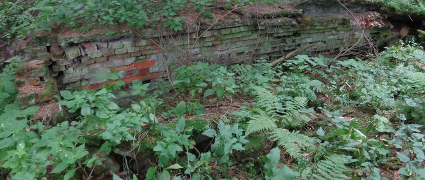
Remote Sens. 2020, 12, x FOR PEER REVIEW 5 of 21
Remote Sens. 2020, 12, 1802 5 of 21
Długa Góra area. Moreover, they were responsible for the construction of the railway siding in
Kolce, which was also part of the Führerhauptquartiere “Riese/Rüdiger”:
area. Moreover, they were responsible for the construction of the railway siding in Kolce, which was
“Prisoners
also part from nearby camps were“Riese/Rüdiger”:
of the Führerhauptquartiere all put together in Dörnhau, to work constructing railroads. They
were located in a separate camp” [33].
“Prisoners from nearby camps were all put together in Dörnhau, to work constructing railroads.
It is also believed that those prisoners were responsible for drift construction in the southern
They were located in a separate camp”. [33]
part of Riese, in Säufer Höhen (Osówka). The Dörnhau camp was liberated on 8 May 1945 and was
into aIthospital for its former
is also believed prisoners
that those [29].were responsible for drift construction in the southern part
prisoners
of Riese, in Säufer Höhen (Osówka). The Dörnhau camp was liberated on 8 May 1945 and was into a
3.1.4. Thefor
hospital Säuferwasser Labour Camp
its former prisoners [29].
The Säuferwasser Labour Camp began operation between May and June of 1944. The prisoners’
3.1.4. The Säuferwasser Labour Camp
main task was to lay the foundation for various buildings. Some outstanding constructions included
The Säuferwasser
the “mess” Labour plant.”
and the “power Camp began operation
The inmates between
also May and
participated in June of 1944. The
the digging prisoners’
of tunnels in
main
Osówka,task was
tree tofelling,
lay the building
foundation for various
roads buildings. Some
and narrow-gauge outstanding
railroads, constructions
digging trenches included
for the
the “mess” and
teletechnical the “powerand
infrastructure, plant.” The inmates
constructing variousalso participated
buildings. in thewas
The camp digging of tunnels
liberated in May in of
Osówka,
1945 [29].tree felling, building roads and narrow-gauge railroads, digging trenches for the teletechnical
infrastructure, and constructing various buildings. The camp was liberated in May of 1945 [29].
3.1.5. The Wüstegiersdorf Labour Camp
3.1.5. The Wüstegiersdorf Labour Camp
The Wüstegiersdorf Labour Camp was a camp for skilled workforce. This camp stood out from
other AL Wüstegiersdorf
The Riese camps. It was Labour Camp
created viawas
thearelocation
camp for skilled workforce.
of a Friedrich Krupp This
AG camp stood
facility fromoutEssen.
from
other AL Riese camps. It was created via the relocation of a Friedrich Krupp AG
It consisted of two workshops (Werk I and Werk II) that specialized in the production of precision facility from Essen.
It consisted
tools of two workshops
and equipment (Figure (Werk I and Werk
2), including II) such
items that specialized
as: the F 32in Stahlholmgurte
the production of(wing
precision
sparstools
for
and
Me-262), M XVIII Zündschraube und Zünder (fuses and detonators) and the W 72 SchwereMe-262),
equipment (Figure 2), including items such as: the F 32 Stahlholmgurte (wing spars for Marine
M XVIII(heavy
Gerät Zündschraube und Zünder The
naval equipment). (fusesconstruction
and detonators)
andand the W 72ofSchwere
assembly Marine Gerät (heavy
the aforementioned items
naval equipment). The construction and assembly of the aforementioned items
required a skilled workforce, which meant that the conditions had to be better than those found in required a skilled
workforce,
the AL “Riese”which meant that the conditions had to be better than those found in the AL “Riese” camps.
camps.
Figure 2. Production
Figure 2. Production chart
chartfor
forthe
theKrupp
Kruppfacility
facilityinin
Wustgiersdorf (Głuszyca)
Wustgiersdorf thatthat
(Głuszyca) includes a list
includes a of
listthe
of
produced elements. Source: Bundesarchiv R3/2006.
the produced elements. Source: Bundesarchiv R3/2006.
3.2. Spatial and Additional Data
3.2. Spatial and Additional Data
The research used data from the archives (aerial photos and topographic maps), as well as
The research
contemporary dataused data from the
(orthophotomaps andarchives
LiDAR).(aerial photos
Complex and were
queries topographic maps),
run against as well as
the documents
contemporary data (orthophotomaps and LiDAR). Complex queries were run
kept by the National Collection of Aerial Photography Archive (NCAP) in Scotland and the National against the
documents
Archives kept byinthe
(NARA) National
the United Collection of Aerial
States, which Photography
resulted Archiveof(NCAP)
in the discovery a uniquein Scotland and
aerial photo.
the National Archives (NARA) in the United States, which resulted in the discovery
The research employed a scan of an original paper photo from the NARA archives. The scan of an of a unique
aerial photo.
identical The
photo research
from NCAP employed
was mosta probably
scan of anaoriginal paper
photocopy of photo from the
the original thatNARA archives.
is currently heldThe
in
scan of The
NARA. an identical
NCAP copy photo
mustfrom
haveNCAP was after
been made mostthe
probably
War wasa over
photocopy of the in
and remained original that is
Great Britain,
currently
while held in NARA.
the original photo was Thetransported
NCAP copy to must haveThe
the USA. been made after
employed photo thewas
War was over and
characterized by
remained in Great Britain, while the original photo was transported to the USA.
mechanical damage, including some warping, scratches and dust marks. The scale of the photo is The employed
photo was characterized by mechanical damage, including some warping, scratches and dust marks.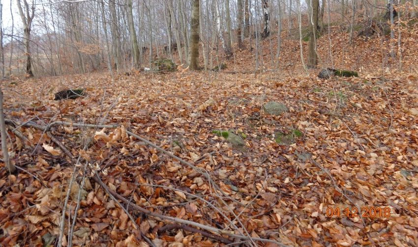
Remote Sens. 2020, 12, 1802                                                                        6 of 21

1:43,000; it was taken on 20.02.1945 with an RB30 camera with a 30-cm negative format and a lens of
200.47 mm focal length, and it covered the entire Riese complex. The photo in question was scanned at
800 DPI and saved in a .tiff format. The authors used it as a main resource to delineate the topography
of the explored camps. In the last stage of conducted research, the team also uncovered an aerial photo
from May 1939, located in the archives of the German Bundesarchiv. However, said photo was not
employed in the described research.
      The authors were also able to find four topographic maps (Messtischblatt series, scale 1:25,000;
1904, 1924, 1934, and 1939) that were used in the interpretation of the aerial photo from 1945.
The contemporary data that were used in the research include data obtained via the use of LiDAR
(Light Detection and Ranging, density of six points/sq. m and altimeter accuracy of about ±15 cm,
acquisition date: 2011), as well as an orthophotomap (GSD 0.25 m, acquisition time: 2016). The LiDAR
data came from a project by the Head Office of Geodesy and Cartography that was carried out for the
whole of Poland. These data are available for free to public administration entities and for scientific
purposes. The spatial data were augmented by witness testimony from the Jewish prisoners of AL
Riese collected shortly after the War (1945–1949) and kept by the Jewish Historical Institute in Warsaw,
and by the testimony of Abraham Kajzer [34,35], who saved some of the notes he took in the camp and
later had them published, as well as testimonies made public by the Freie Universität Berlin [36].

3.3. Data Processing
     In order to perform a proper integration of spatial data with actual data, it was also necessary
to perform an orthorectification of aerial photographs [37], as well as the georeferencing of historical
maps [38]. The orthorectification of the 1945 aerial photo was performed using PCI Geomatica software
(PCI Geomatica OrthoEngine, Quebec, PQ, Canada). The outcome of that process is something called
an image georeference, in which the photo is geocoded with a map projection and can be integrated
with other spatial data in Geographic Information System (GIS) software. Indeed, the orthorectification
process has to be applied in this case due to the very significant land leveling (land undulations)
in the area under study, reaching 670 meters. The lack of the required camera interior information
meant [39] that it was necessary to conduct that process using indirect georeferencing carried out via
a spatial (independent) space resection [40]. The first step was to establish the interior orientation
parameters based on the identification of fiducial markers and measurements between each set of
fiducials along the edge of the photo. In our case, that meant that both the principal points, as well as
the lens distortion, were unknown factors. However, we could ignore the lens distortion factor as it is
secondary factor in comparison to other sources of deformation as result from, inter alia, the physical
state of the paper copy of the archive photo. Additionally the analysed area is in the middle of the
photo, where the distortions are much less prevalent than at the edges.
     Elements of exterior orientation were established using Ground Control Points (GCPs) visible
on the picture below and whose spatial coordinates are known. The exterior orientation was also
accomplished using GCPs. The orthorectification orthoadjustment process used 23 GCP points and
seven Check Points (CP). GCP and CP were natural features identified both on the historical aerial
photo and on the existing orthophotomap from 2016 with a terrain pixel of 0.25 m. The flat (X, Y)
coordinates ware measured from orthophotomap, and heights (Z) from the existing DTM, with the
resolution of 1 m × 1 m, based on LiDAR data. Natural features mostly encompassed road junctions
and corners of structures. Unfortunately, this meant that nonoptimal targets, such as building corners,
had to be chosen sometimes, as they were the only relatively static objects in the landscape that were
identifiable in both the historical and the contemporary context [41]. The analysis of the precision of
orthorectification orthoadjustment was based on the Root Mean Square Error (RMSE). An accuracy of
12.9 m (0.3 mm in a 1:43,000 reference scale) was taken as an acceptable RMSE. Orthoadjustment of the
1945 aerial photo achieved an RMSE of 12.40 m (on Check Points). We found this result as satisfactory
and corresponding to the scale and quality of archival source photo.
Remote Sens. 2020, 12, 1802 7 of 21
Georeferencing of historical maps was conducted with the use of ArcGIS software (ArcGIS v.10.6,
ESRI, Inc., Redlands, CA, USA). The authors obtained the RMSE factor for georeferencing of a
topographical map (Messtischblatt series) of around 6 m with 10 ground control points with affine
transformation. The georeferencing process that used second-order polynomial transformation did
not improve the results. It can therefore be assumed that the map sheets used did not display more
complex distortions, which could be removed with a higher transformation order.
To visualize the digital elevation model created using the LiDAR data, the authors applied Relief
Visualization Toolbox (RVT v. 2.2.1, Research Centre of the Slovenian Academy of Sciences and Arts,
Ljubljana, SLO) software [42]. Sky-View Factor (SVF) [43], Openness [44], and Local Dominance [43]
were used for each of the analysed areas, and many different testing parameters were applied. The high
usefulness of SVF with a radius of 5 m, Openness Positive (OP) with a radius of 10 m, and Local
Dominance (LD) with the radius filter parameters set to (minimum/maximum: 10 m) is worth noting
here. Well-applied parameters allowed us to emphasize topographic elements that were important
from the point of view of the conducted research. After being successfully orthorectified, the historical
aerial image was subjected to a visual photointerpretation in order to produce plans of the camps for
the tested areas. Visual photointerpretation was conducted with the support of topographic maps and
actual orthophotographs of the same area. Moreover, the authors used complementary spatial data,
such as LiDAR data products, to improve the interpretation of camp object features. All spatial data
have been integrated using ArcGIS software. A walkover survey was also carried out, which resulted
in a technical description of the remains of the camp facilities.
4. Results
4.1. Spatial Data Integration and Photointerpretation
4.1.1. Wolfsberg Labour Camp
The scale of the aerial photo does not allow for the application of direct features to delineate the
camp area. Therefore, indirect features were used in that task: the surrounding roads, the footpaths,
and the general outline of the buildings seen on the archive photo (Figure 3a) that received the SVF
treatment (5 m: Figure 3d), which additionally emphasized the topography of the terrain. The area
of the camp, when established via use of the aforementioned processes, amounted to 3.60 hectares.
The authors was able to identify 29 buildings, which ranged in size from 30 sq. m to around 490 sq. m
(Figure 3b). It was not possible to locate some of the camp objects mentioned by witnesses in their
testimonies; the location of the small wooden huts with a round base, as well as that of the dugouts,
was never established. Such small objects are not visible on the 1945 photo, and the changes to the
land did not withstand the passage of time. At the moment, the southern part of the former camp area
is covered by trees, as can be seen on the ortophotomap (Figure 3c). It is there that one can find the
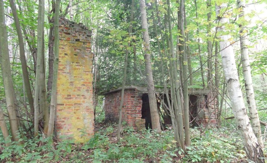
remains of the camp buildings: the foundation for the barracks and the kitchen (Figure 4), the lavatory,
the water tank (Figure 5), the garbage dump, and the sump. The wooden and metal elements of the
barracks were looted, and one can observe many signs of conscious salvage of brick material on many
surviving buildings. Different sizes and divisions of the former camp buildings allow for the formation
of a hypothesis that the buildings were put up very rapidly by an unskilled workforce consisting
of prisoners. It seems that the construction was carried out according to executive orders and not
construction plans or blueprints. The fact that there was no outside plastering on the buildings points
to their temporary nature and the limited timeframe of their usage (1–2 years). Now, there are some
single-family houses located in the remainder of the former camp area.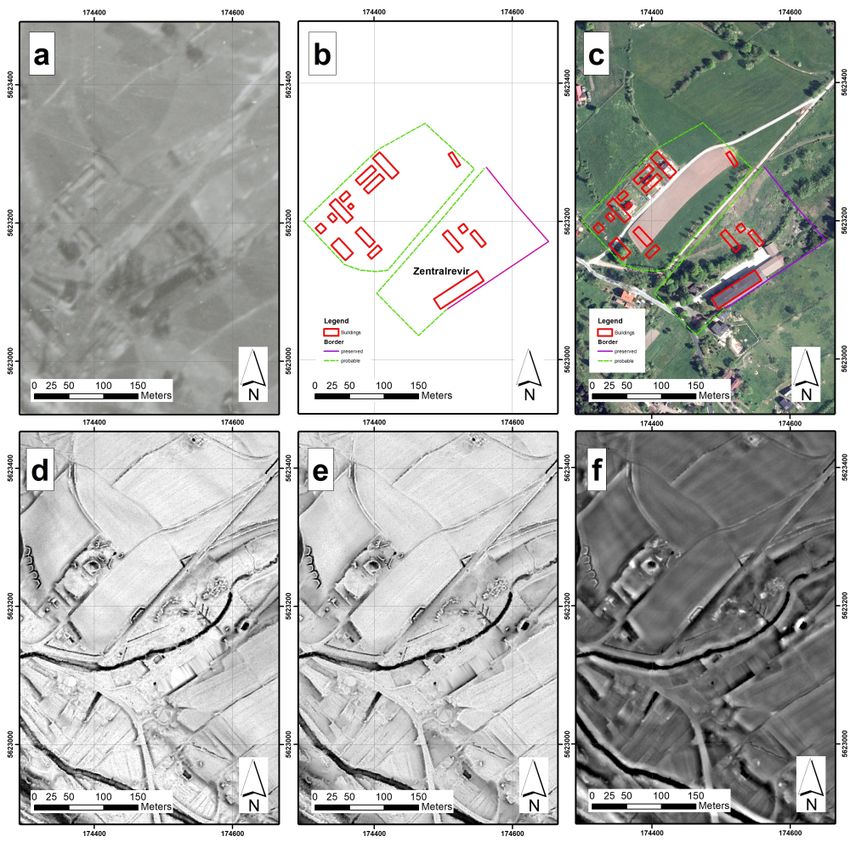
Remote Sens. 2020, 12, x FOR PEER REVIEW                                                                           8 of 21

Remote
RemoteSens.  2020,12,
       Sens.2020,  12,1802
                       x FOR PEER REVIEW                                                                            88 of
                                                                                                                       of 21
                                                                                                                          21

     Figure 3. Labour camp AL Wolfsberg: (a) Aerial photo taken in February 1945 (© NARA), (b)
     reconstruction
     Figure 3. Labour of camp
                           campbased     on ’45 photo:
                                    AL Wolfsberg:     (a)1Aerial
                                                            – bath,photo
                                                                      2 – kitchen,
                                                                            taken in3 –February
                                                                                         water tank,
                                                                                                  19454 (©
                                                                                                         – assembly
                                                                                                             NARA),
      Figure 3. Labour camp AL Wolfsberg: (a) Aerial photo taken in February 1945 (© NARA), (b)
     ground,  5 – barracks  of  the camp  HQ  and  the  staff, (c) recent  orthophoto  of camp
     (b) reconstruction of camp based on ’45 photo: 1—bath, 2—kitchen, 3—water tank, 4—assembly area  with  outlined
      reconstruction of camp based on ’45 photo: 1 – bath, 2 – kitchen, 3 – water tank, 4 – assembly
     camp  plan
     ground,     (© Head Office
              5—barracks    of the of Geodesy
                                    camp  HQ andandthe
                                                     Cartography      in Poland),
                                                        staff, (c) recent          (d) SVF
                                                                           orthophoto        image
                                                                                        of camp    (radius
                                                                                                 area        5m), (e)
                                                                                                      with outlined
      ground, 5 – barracks of the camp HQ and the staff, (c) recent orthophoto of camp area with outlined
     Openness
     camp planpositive
                  (© Headimage
                             Office(radius   10m),and
                                     of Geodesy     (f) Cartography
                                                         Local Dominance        image(d)(min./max.:
                                                                         in Poland),      SVF image10m      – 10m).
                                                                                                       (radius  5 m),
      camp plan (© Head Office of Geodesy and Cartography in Poland), (d) SVF image (radius 5m), (e)
     Coordinate
     (e) Openness grid: UTM Zone
                     positive  image34(radius
                                        N (EPSG:  32634).
                                               10 m),  (f) Local Dominance image (min./max.: 10 m – 10 m).
      Openness positive image (radius 10m), (f) Local Dominance image (min./max.: 10m – 10m).
     Coordinate grid: UTM Zone 34 N (EPSG: 32634).
      Coordinate grid: UTM Zone 34 N (EPSG: 32634).

                 Figure of
     Figure 4. Remains     Remains
                        4. the camp of the camp
                                    kitchen, AL kitchen, AL photo
                                                Wolfsberg;  Wolfsberg; photo P. Lewandowski.
                                                                  P. Lewandowski.

      Figure 4. Remains of the camp kitchen, AL Wolfsberg; photo P. Lewandowski.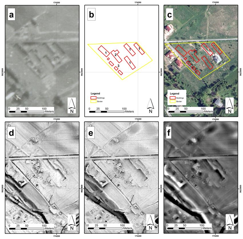
Remote Sens.
Remote Sens. 2020, 12, x1802
2020, 12, FOR PEER REVIEW 99of
of21
21
Figure 5. Figure
Remains Remains
5. of of the
the camp’s camp’s
water water
tank, tank, AL Wolfsberg;
AL Wolfsberg; photo P. Lewandowski.
photo P. Lewandowski.
4.1.2. Kaltwasser Labour Camp
4.1.2. Kaltwasser Labour Camp
Based on the interpretation of the aerial photo, we were able to identify five barracks, which some
of theBased on the
witnesses interpretation
mentioned of testimonies:
in their the aerial photo, we were able to identify five barracks, which
some of the witnesses mentioned in their testimonies:
“Four long buildings with big windows and glass doors were surrounded by a wire fence. Apart from
“Four long buildings with big windows and glass doors were surrounded by a wire fence. Apart from
buildings numbered from 2 to 5, there was also a kitchen there”. [45]
buildings numbered from 2 to 5, there was also a kitchen there” [45].
“The camp
“The camp was
was different
differentfrom
fromAuschwitz.
Auschwitz.Four
Fourlong buildings
long with
buildings bigbig
with windows andand
windows glassglass
doors.
doors.
Surrounded by razor wire fence. Apart from buildings with rising numbers, there was also a kitchen
Surrounded by razor wire fence. Apart from buildings with rising numbers, there was also a kitchen there”
[45]. there”. [45]
Two
Two smaller
smaller buildings
buildings are are also
also visible;
visible; however,
however, their
their function
function was
was impossible
impossible to to establish
establish with
with
certainty.
certainty. The
The outlines
outlines of of the
the buildings
buildings established
established based
based on on the
the aerial
aerial photo
photo were
were compared
compared using using
an
an OP
OP (10
(10 m: Figure
Figure 6e),
6e), which
which allowed
allowed forfor the
the partial
partial modification
modification of their outlines. One One ofof the
the
smaller
smaller buildings (recognized on the aerial photo: Figure 6a) has remained in
(recognized on the aerial photo: Figure 6a) has remained in good shape until today. good shape until
today.
A fieldAanalysis
field analysis
allowed allowed to identify
to identify it as a it as a cesspool/overflow
cesspool/overflow separator
separator (concrete,
(concrete, constructed
constructed using
using formwork), which transported sewage outside of the camp area (Figure
formwork), which transported sewage outside of the camp area (Figure 7). Clay pipes connect to the 7). Clay pipes connect
to the separator.
separator. The camp’s
The camp’s fence fence was delineated
was delineated usingusing
indirectindirect features,
features, the surrounding
the surrounding roadsroads and
and camp
camp infrastructure.
infrastructure. The campThe camp
area wasareaaround
was around 1.12 hectares
1.12 hectares (Figure (Figure 6b). of
6b). Most Most
theof the fence
fence elementselements
in the
in the analysed
analysed labour labour
camps camps
consistedconsisted
of woodenof wooden
poles that poles that supported
supported a razor wirea razor wire framework.
framework. The entry
The
gateentry gatemade
was also was of also madeDue
wood. of wood.
to theirDue to their
makeshift makeshift
nature, nature,
the fence andthegatefence
wereand
the gate were the
first structures
first structures
to fall to looterstoshortly
fall toafter
looters
theshortly after the
War. Despite theWar. Despite
fact that thethe
within fact that
area of within
the formerthe area of the
Kaltwasser
former Kaltwasser camp one can still recognize fragments of the foundation
camp one can still recognize fragments of the foundation of the camp’s buildings, the terrain was of the camp’s buildings,
the terrain
divided was
into divided
smaller into(the
plots smaller plots (the part
southwestern southwestern part ofinit),order
of it), probably probably in order
to prepare themto prepare
for sale.
them for sale. At the southeastern border of the camp, a single-family
At the southeastern border of the camp, a single-family house was built (Figures 6c and 8). house was built (Figures 6c
and 8).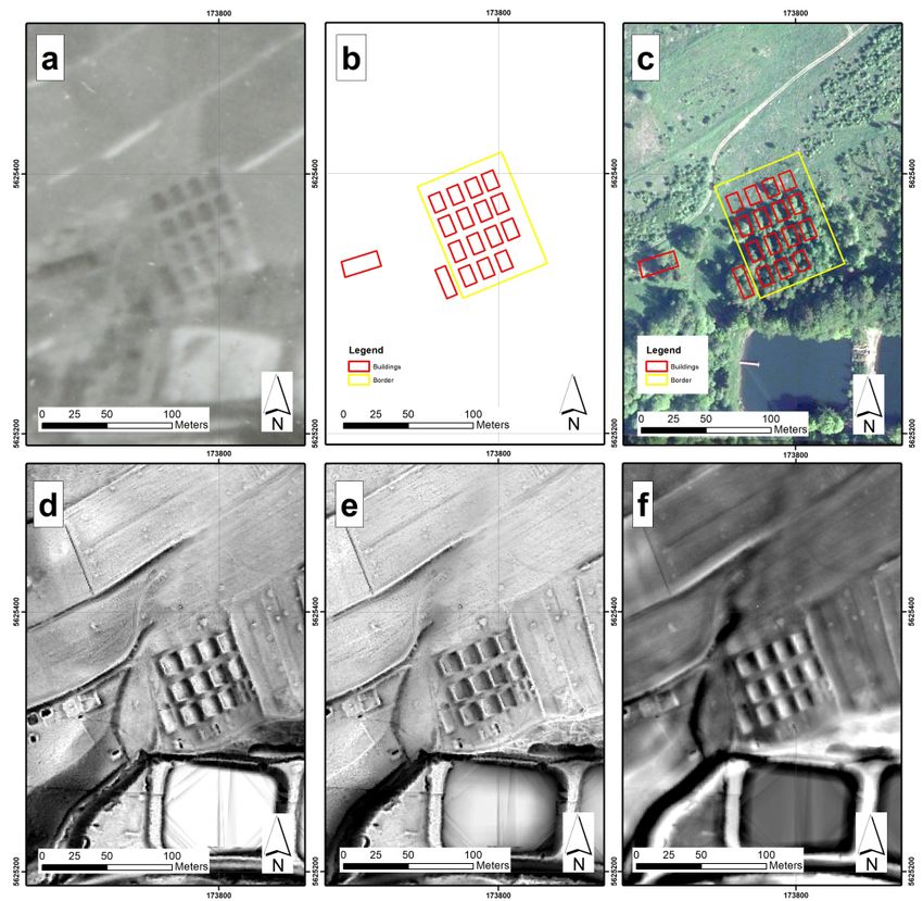
Remote Sens. 2020, 12, x FOR PEER REVIEW                                                                             10 of 21
                       1802
Remote Sens. 2020, 12, x FOR PEER REVIEW                                                                             10 of 21

     Figure  6. Labour
     Figure 6.  Labourcamp
                         campAL  ALKaltwasser:
                                     Kaltwasser:(a)(a)
                                                    ’45’45  aerial
                                                         aerial     photo
                                                                photo      (© NARA),
                                                                       (© NARA),          (b) reconstruction
                                                                                     (b) reconstruction  of campof based
                                                                                                                   camp
     Figure
     based   6. Labour
            on ’45 photo:camp    AL  Kaltwasser:
                            1 – inmates’           (a) ’45  aerial  photo  (© NARA),      (b) reconstruction   of  camp
     on ’45 photo:   1—inmates’    barracks,barracks,
                                             2—kitchen  2 –and
                                                             kitchen  and suspected
                                                                 suspected               HQ, 3 –(c)cesspool,
                                                                            HQ, 3—cesspool,                   (c) recent
                                                                                                     recent orthophoto
     based  on ’45ofphoto:
     orthophoto       camp  1 – inmates’
                            area   with    barracks,
                                        outlined  camp  2 –plan
                                                            kitchen
                                                                  (©  and suspected
                                                                     Head   Office  of   HQ, 3 – and
                                                                                       Geodesy     cesspool,  (c) recent
                                                                                                       Cartography    in
     of camp area with outlined camp plan (© Head Office of Geodesy and Cartography in Poland),
     orthophoto
     Poland),  (d) of
                   SVFcamp  area
                        image      with outlined
                                (radius 5m),  (e) camp planpositive
                                                  Openness       (© Head    Office
                                                                         image     of Geodesy
                                                                                 (radius   10m),  and
                                                                                                 (f)   Cartography
                                                                                                     Local  Dominance in
     (d) SVF image (radius 5 m), (e) Openness positive image (radius 10 m), (f) Local Dominance image
     Poland),
     image     (d) SVF image
            (min./max.:        –(radius 5m), (e) Openness       positive image   (radius32634).
                                                                                           10m), (f) Local Dominance
     (min./max.:   10 m – 10m
                          10 m).  10m). Coordinate
                                   Coordinate  grid: grid:
                                                       UTMUTM ZoneZone
                                                                     34 N 34 N (EPSG:
                                                                          (EPSG:   32634).
     image (min./max.: 10m – 10m). Coordinate grid: UTM Zone 34 N (EPSG: 32634).

        Figure
     Figure     7. Concrete
            7. Concrete     remains
                        remains     of the
                                of the     presumed
                                       presumed      cesspool,
                                                 cesspool, AL AL  Kaltwasser;
                                                               Kaltwasser;    photo
                                                                           photo     P. Lewandowski.
                                                                                 P. Lewandowski.
     Figure 7. Concrete remains of the presumed cesspool, AL Kaltwasser; photo P. Lewandowski.
Remote Sens. 2020, 12, x FOR PEER REVIEW 11 of 21
Remote Sens.
Remote 2020,
Sens. 12,12,
2020, 1802
x FOR PEER REVIEW 11 21
11 of of 21
Figure 8. Contemporary house built on the site of the former AL Kaltwasser camp; photo P
Lewandowski.
Figure 8. Contemporary house built on the site of the former AL Kaltwasser camp; photo P Lewandowski.
Figure 8. Contemporary house built on the site of the former AL Kaltwasser camp; photo P
Lewandowski.
4.1.3. Dörnhau Labour Camp
4.1.3. Dörnhau Labour Camp
The camp was located by the road from Dörnhau (now called Kolce) to Tannhausen (now Jedlinka).
The camp was located by the road from Dörnhau (now called Kolce) to Tannhausen (now
The photo from 1945 (Figure 9a) shows two separate camps: one in the north with camp barracks and
Jedlinka). The photo from 1945 (Figure 9a) shows two separate camps: one in the north with camp
4.1.3.
one Dörnhau
in the south, Labour
where Camp
barracks and one in theasouth,
linen textile
where factory was located
a linen textile factory(Figure 10a).(Figure 10a).
was located
The camp was located by the road from Dörnhau (now called Kolce) to Tannhausen (now
Jedlinka). The photo from 1945 (Figure 9a) shows two separate camps: one in the north with camp
barracks and one in the south, where a linen textile factory was located (Figure 10a).
Figure
Figure 9. 9. Labour
Labour Camp
Camp ALAL Dörnhau:
Dörnhau: (a)(a)
’45’45 aerial
aerial photo
photo (©(© NARA),
NARA), (b)(b) reconstruction
reconstruction of of
campcamp
based
onbased on ’45(c)photo,
’45 photo, recent(c)orthophoto
recent orthophoto
of campofareacamp area
with with outlined
outlined camp
camp plan (©plan (©Office
Head Head of Office of
Geodesy
and Cartography in Poland), (d) SVF image (radius 5 m), (e) Openness positive image (radius 10 m),
(f) Figure 9. Labour Camp
Local Dominance imageAL Dörnhau:10
(min./max.: (a)m’45 aerial
– 10 photo (© NARA),
m). Coordinate (b) reconstruction
grid: UTM of camp
Zone 34 N (EPSG: 32634).
based on ’45 photo, (c) recent orthophoto of camp area with outlined camp plan (© Head Office ofRemote Sens. 2020, 12, x FOR PEER REVIEW 12 of 21
Geodesy and Cartography in Poland), (d) SVF image (radius 5m), (e) Openness positive image
(radius 10m), (f) Local Dominance image (min./max.: 10m – 10m). Coordinate grid: UTM Zone 34 N
Remote Sens.
(EPSG:2020, 12, 1802
32634). 12 of 21
(a) (b)
Figure10.
Figure 10. The
The remains
remains ofof the
thefence
fencesurrounding
surroundingthe theformer
formerALALDörnhau
Dörnhau camp: (a) (a)
camp: the the
southern part
southern
of the factory building (white walls) and a row of concrete fence posts with modern fencing
part of the factory building (white walls) and a row of concrete fence posts with modern fencing mesh; (b)
the row
mesh; of row
(b) the concrete post fence
of concrete is restricting
post fence the the
is restricting former camp
former camparea
areafrom
fromthe
the northeast; in the
northeast; in the
backgroundfactory
background factorybuildings;
buildings;photos:
photos:A.
A.Burakowski.
Burakowski.
Thefactory
The factoryalso
alsoserved
servedasasaamedical
medicalfacility
facilityfor
forsick
sickprisoners
prisoners(called
(calledZentralrevier
Zentralrevierin inGerman),
German),
andwas
and wasvery
veryoften
oftenerroneously
erroneouslycalled
calledaahospital.
hospital.We Wewere
werenotnotable
abletotodelineate
delineatethe thecamp’s
camp’sborders
borders
basedononthe
based the photo.
photo. They
They were
were instead
instead established
established basedbased on indirect
on indirect features.
features. Together,
Together, the two the two
parts
ofparts of thecovered
the camp camp covered 5.33 hectares.
5.33 hectares. OP (10 OP (10 m: 9e)
m: Figure Figure
was9e)
usedwasin used in the interpretation
the interpretation process,process,
which,
which, adespite
despite loss inathe loss in the perception
perception of topography
of topography in the
in the case caseDörnhau
of the of the Dörnhau camp, for
camp, allows allows for a
a better
betterperception
visual visual perception in comparison
in comparison to SVF. to SVF.
Theremains
The remainsofofthe thebarbed
barbedwirewirefence
fencethat
thatsurrounded
surroundedthe thesouthern
southernpart partofofDörnhau
Dörnhaufrom fromthethe
factoryside
factory sideare arestill
stillvisible
visibletoday
today(Figure
(Figure9c).9c).The
Thefence
fencewas
wasconstructed
constructedusing usingpremade
premadeconcrete
concrete
elementsthat
elements thatsupported
supportedaarazorrazorwire
wireframework
framework(Figure
(Figure10b).
10b).The
Thelatter
latterisisalso
alsostill
stillvisible
visibletoday.
today.
Theortophotomap
The ortophotomapalso alsoshows
showsthe thefence
fence(Figure
(Figure9c),
9c),which
whichisisnot
notvisible
visibleon onthethephoto
photofrom
from1945.
1945.
Theobjects
The objectsininthethenorthern
northernpartpartofofthe
thecamp
camp(the
(thebarracks)
barracks)were
weredismantled
dismantledafter after1945
1945andandtoday
todaythethe
areaisiscovered
area coveredininprivate
privatehouses.
houses.However,
However,ininthe theareas
areasthat
thatwere
werenotnotbuilt
builtover,
over,eveneventoday
todayone onecan
can
stillsee
still seeaafewfewelements
elementsofofthethecamp’s
camp’sfoundations.
foundations.Very Veryoften,
often,the
theoutline
outlineofofthethecamp’s
camp’sbarracks
barrackscan can
onlybebeidentified
only identified byby using
using terrain
terrain irregularities
irregularities andand spotting
spotting individual
individual bricksbricks
lying lying
around around that
that used
toused
formtotheform the foundation.
foundation. The existingTheconstruction
existing construction materials
materials have have been
been damaged damaged
through through
exposure to
exposure
the elements. to the elements.
4.1.4.
4.1.4.Säuferwasser
SäuferwasserLabour
LabourCamp
Camp
The
Thescale
scaleofofthe
theaerial
aerialphoto
photofrom
from1945
1945(Figure
(Figure11a)
11a)does
doesnotnotallow
allowforforthe
theapplication
applicationofofdirect
direct
features
featuresto todelineate
delineate the camp area. Therefore,
the camp indirectindirect
area. Therefore, features were usedwere
features in thatused
task:inthethat
surrounding
task: the
roads, the footpaths,
surrounding roads, theandfootpaths,
the general andoutline of the buildings
the general outline ofseen on the archive
the buildings photo
seen on the that received
archive photo
the SVF
that treatment
received the SVF(5 m: Figure 11d),
treatment (5 m:which
Figureadditionally
11d), which emphasized
additionally the topography
emphasized the of the terrain.
topography of
The
thearea of theThe
terrain. camp for of
area prisoners,
the camp whenforestablished
prisoners, via
whenuse established
of the aforementioned
via use ofprocesses, amounted
the aforementioned
toprocesses,
0.58 hectares. The authors
amounted to 0.58was able toThe
hectares. identify 10 buildings,
authors ranging
was able to identifyin size from 40 sq.ranging
10 buildings, m to around
in size
540
fromsq.40
msq.(Figure 11b). At540
m to around thesq.
moment, the 11b).
m (Figure southern
At thepart of the former
moment, camp area
the southern partisofcovered by trees,
the former camp
asarea
canisbecovered
seen onby the ortophotomap (Figure 11c). It is there that one can find the remains
trees, as can be seen on the ortophotomap (Figure 11c). It is there that one can find of the camp
buildings:
the remains the of
foundation
the campfor the barracks
buildings: the (Figures
foundation 12 and
for 13)
theand the kitchen,
barracks (Figuresthe 12
lavatory,
and 13) theand
waterthe
tank, garbage
kitchen, dump, and
the lavatory, the sump.
the water tank, The wooden
garbage dump, andandmetal elements
the sump. Theofwooden
the barracks wereelements
and metal looted,
and onebarracks
of the can observewere signs of conscious
looted, and one salvage of brick
can observe material
signs on manysalvage
of conscious surviving buildings.
of brick material on
many surviving buildings.Remote Sens. 2020, 12, x FOR PEER REVIEW 13 of 21
Remote Sens.
Remote Sens. 2020, 12, x1802
2020, 12, FOR PEER REVIEW 13of
13 of21
21
Figure 11. Labour camp AL Säuferwasser: (a) ’45 aerial photo (© NARA), (b) reconstruction of
Figure
camp
Figurebased Labour
on ’45camp
11. Labour campAL
photo: AL – Säuferwasser:
1 Säuferwasser:
presumed camp (a)(a) ’45 aerial
kitchen,
’45 aerial 2 – photo
photo“roll (© NARA),
(©call”
NARA),square, 3(b) reconstruction
– suspected
(b) reconstruction HQ,
of of
(c)
camp
camp
basedbased
recent on ’45on
orthophoto ’45 photo:
photo: of camp1 – presumed
1—presumed with camp
area camp kitchen,
outlined
kitchen, camp
2—“roll2 –plan
“rollsquare,
call” call”Head
(© square, 3 – suspected
Office
3—suspected HQ, (c)HQ,
of Geodesy (c)
and
recent
recent orthophoto
Cartography
orthophoto ofincamp ofarea
Poland),camp
(d) area
SVF
with withcamp
image
outlined outlined
(radius 5m),
plan camp plan
(©(e)Head
Openness (© positive
Office Head
of Office
image
Geodesy of
and Geodesy
(radius 10m),and
Cartography (f)
in
Cartography
Poland),
Local Dominancein Poland),
(d) SVF image (d) SVF
image(radius image
5 m),
(min./max.: (radius
– 10m).5m),
(e) Openness
10m (e) Openness
positive
Coordinate image positive
grid:(radius
UTM image
10 m),
Zone 34(f) (radius
N Local
(EPSG: 10m), (f)
Dominance
32634).
Local
imageDominance
(min./max.:image10 m –(min./max.: 10m – 10m).
10 m). Coordinate grid:Coordinate
UTM Zonegrid: 34 NUTM(EPSG: Zone 34 N (EPSG: 32634).
32634).
Figure 12.
Figure Remainsofofthe
12. Remains thebarrack’s
barrack’sbrick
brickunderpinning,
underpinning, former
former ALAL Säuferwasser
Säuferwasser camp;
camp; photo
photo P.
P. Lewandowski.
Figure 12. Remains of the barrack’s brick underpinning, former AL Säuferwasser camp; photo P.
Lewandowski.
Lewandowski.Remote
RemoteSens. 2020,12,
Sens.2020, 12,1802
x FOR PEER REVIEW 14
14 of
of 21
21
Figure 13. Remains of the barrack’s foundation, AL Säuferwasser; photo P. Bylina.
Figure 13. Remains of the barrack’s foundation, AL Säuferwasser; photo P. Bylina.
4.1.5. Wüstegiersdorf Labour Camp
4.1.5. Wüstegiersdorf Labour Camp
The photo from 20 February 1945 (Figure 14a) shows the camp in the last stage of its functioning.
Most The photothefrom
probably, camp20whereFebruary 1945laborers
the forced (Figurewere 14a)keptshowswas the camp in the
not evacuated last stage
in February ofbut
1945 its
functioning. Most probably, the camp where the forced laborers were kept
continued operating until May of the same year. Seventeen camp buildings were located in the process was not evacuated in
February
of 1945 the
interpreting butphotos
continued operating
(Figure untilwere
14b). They Maysurrounded
of the sameby year. Seventeen
a fence. camparea
The camp buildings were
was around
located in the process of interpreting the photos (Figure 14b). They were surrounded
0.65 hectares. Apart from the area for the forced labourers, two other buildings were also located by a fence. The
camp area
nearby: one was
closearound 0.65 hectares.
to the western border ofApart from(most
the camp the area for the
probably theforced labourers,
headquarters two other
building) and
buildings were also located nearby: one close to the western border of the camp
another one, whose purpose was difficult to establish. After a SVF (5 m: Figure 14d) and OP analysis, (most probably the
headquarters building) and another one, whose purpose was difficult to establish.
the second building turned out to have been a cluster of three buildings, instead of, as was previously After a SVF (5 m:
Figure 14d)
assumed, and entity.
a single OP analysis,
It couldthe second
have building
functioned as theturned outthe
kitchen, to workshop,
have beenand a cluster of three
the warehouse.
buildings, instead of, as was previously assumed, a single entity. It
Some elements of the former camp survived to the present day (Figure 14c). The foundation of could have functioned as the
the
kitchen, the workshop, and the warehouse. Some elements of the former
barracks and administrative buildings is still visible. The area is covered by a mixed forest in the camp survived to the
present
south andday (Figure
is one 14c).
of the fewThe foundation
camps of the barracks
whose remains and administrative
are still visible today (Figures buildings
15 and 16) is still
andvisible.
where
The area is covered by a mixed forest in the south and is one of the few camps
the terrain was not built over. It is believed that, in the future, Wüstegiersdorf can be appropriately whose remains are
still visible today (Figures 15 and 16) and where the terrain was not built over. It is believed that, in
commemorated because the problem of purchase of land with existing buildings would not exist here.
the future, Wüstegiersdorf can be appropriately commemorated because the problem of purchase of
land with existing buildings would not exist here.RemoteSens.
Remote Sens.2020, 12,x1802
2020,12, FOR PEER REVIEW 15of
15 of21
21
Remote Sens. 2020, 12, x FOR PEER REVIEW 15 of 21
Figure 14. Presumed forced labour camp for Krupp factory in Wüstegiersdorf (Krupp Lager für die
Figure 14.
Figure Presumed
14. Presumed
Zwangsarbeiter forced labour
labour
Wüstegiersdorf):
forced camp
(a)camp for Krupp
’45 aerial
for Krupp factory
photo (© NARA),
factory in Wüstegiersdorf
in Wüstegiersdorf (Krupp
(b) reconstruction of camp
(Krupp Lager
Lager für die
based
für die
on
Zwangsarbeiter
’45 photo,(c) recent Wüstegiersdorf):
orthophoto of (a)
the ’45
area aerial
with photo
outlined(© NARA),
camp plan (b)
(© reconstruction
Head Office
Zwangsarbeiter Wüstegiersdorf): (a) ’45 aerial photo (© NARA), (b) reconstruction of camp based on ofof camp
Geodesy based
and
on ’45 photo,recent
Cartography
’45 photo,(c) in(c)Poland),
recent orthophoto of area
(d) SVFofimage
orthophoto the the area
withwith
(radius 5m),outlined
campcamp
(e) Openness
outlined plan (© Head
planpositive
(© Head image Office
Office(radius of10m),
Geodesy
of Geodesy (f)
and
and
Local Cartography
Dominance
Cartography in Poland), (d)
image (min./max.:
in Poland), SVF
(d) SVF image image
10m (radius (radius
– 10m). 5m), 5 m),
Coordinate (e) Openness
grid: UTM
(e) Openness positive
Zoneimage
positive image
34 N (EPSG:(radius 10
(radius32634). m),
10m), (f)
(f) Local
Local Dominance
Dominance image
image (min./max.:
(min./max.: 10m 10 –m10m).
– 10 m). Coordinate
Coordinate grid:
grid: UTM UTM Zone
Zone 34(EPSG:
34 N N (EPSG: 32634).
32634).
Figure15.
Figure Artificially
15.Artificially formed
formed terraces
terraces withwith remains
remains of a chimney,
of a chimney, KruppKrupp LZA Wüstegiersdorf;
LZA Wüstegiersdorf; photo
photo
P. P. Lewandowski.
Lewandowski.
Figure 15. Artificially formed terraces with remains of a chimney, Krupp LZA Wüstegiersdorf; photo
P. Lewandowski.Remote Sens. 2020, 12, 1802 16 of 21
Remote Sens. 2020, 12, x FOR PEER REVIEW 16 of 21
(a) (b)
Figure 16. The remains of the barracks of the Krupp LZA Wüstegiersdorf: (a) remains of the chimney;
Figure 16. The remains of the barracks of the Krupp LZA Wüstegiersdorf: (a) remains of the
please, note the two-sided access to the furnace, photo P. Lewandowski; (b) the remains of the presumed
chimney; please, note the two-sided access to the furnace, photo P. Lewandowski; (b) the remains of
pantry, photo P. Bylina.
the presumed pantry, photo P. Bylina.
4.2. Field Survey of the Remains of the Forced Labour Camps
4.2. Field Survey of the Remains of the Forced Labour Camps
The description of the technical condition of the remains of the AL camps remains based on field
studies The description
conducted of the technical
in December 2018 andcondition of the remains
in September of the
2019. Field testsAL camps
took into remains based
account the on
state
field studies conducted in December 2018 and in September 2019. Field tests
of the camps’ remains, masonry structure inspection, as well as manual testing of building materials took into account the
statesplitting
(e.g., of the camps' remains,
test, manual masonry
material structure
strength inspection,
test, etc.). as well as manual
The observations testing
were carried outofatbuilding
the AL
materials
Riese (e.g., splitting
subcamps: test,Kaltwasser,
Wolfsberg, manual material strength Dörnhau,
Märzbachtal, test, etc.). and
The Säuferwasser.
observations were The carried
following out
at the AL Riese subcamps: Wolfsberg, Kaltwasser,
problems were observed among the remains of the studied camps: Märzbachtal, Dörnhau, and Säuferwasser. The
following problems were observed among the remains of the studied camps:
(1) The lack of specific plans of camps is visible on the layout of the structure and foundation
1) of Theitslack of specific
elements (e.g.,plans of camps
Figures 3 and is9).visible on thefacilities
The camp layout ofare
thelocated
structure and foundation
randomly of its
and against
elements
their (e.g., Figures
functionality 3 and 9). The
and operational camp
safety. Campfacilities are and
kitchens located
foodrandomly
warehouses, andasagainst
well astheir
the
baths, are often situated in low grounds and morasses. Camp baths were located asthe
functionality and operational safety. Camp kitchens and food warehouses, as well as baths,
close as
possible to streams or surface intakes (common in depressions) of water, not taking into accountto
are often situated in low grounds and morasses. Camp baths were located as close as possible
streamsoutflows
sewage or surface intakes (common
(corresponding in depressions)
slopes). of water,
The camp barracks notplaced
were takingnot
into accountrows
in regular sewageat
appropriate intervals but tightly in favorable terrain, which adapted to the needs of the camp atat
outflows (corresponding slopes). The camp barracks were placed not in regular rows
appropriate
the lowest cost intervals but tightly
of the work done. in favorable terrain, which adapted to the needs of the camp at
the lowest cost of the work done.
(2) The lack of proper load-bearing walls and low quality of concrete structures were observed
2) The lack of proper load-bearing walls and low quality of concrete structures were observed
(Figure 4). Exterior walls with a height of 1 to 1.5 meters made of brickwork having a thickness of
(Figure 4). Exterior walls with a height of 1 to 1.5 meters made of brickwork having a thickness
25 to 40 cm; the cement-lime mortar layer is uneven and varies from 1 to 3 cm thick. Partitions were
of 25 to 40 cm; the cement-lime mortar layer is uneven and varies from 1 to 3 cm thick.
made from a single brick wall. Concrete constructions lacked steel reinforcements. The concrete
Partitions were made from a single brick wall. Concrete constructions lacked steel
mix contained ill-sorted aggregate composed of local rocks: Carboniferous gravel (weathered
reinforcements. The concrete mix contained ill-sorted aggregate composed of local rocks:
Carboniferous conglomerate) and broken fragments of Neogene basalts.
Carboniferous gravel (weathered Carboniferous conglomerate) and broken fragments of
(3) Lack of proper horizontal and vertical leveling of external walls (Figures 4 and 7)—the levels
Neogene basalts.
were transferred using formwork boards.
3) Lack of proper horizontal and vertical leveling of external walls (Figures 4 and 7) – the levels
(4) The primary building materials for building the most of the camp facilities were mortar-bonded
were transferred using formwork boards.
bricks and wooden elements (recently not present). The red ceramic brick (Figure 4) was bonded
4) The primary building materials for building the most of the camp facilities were mortar-bonded
using mortar made of cement mixed with lime and ill-sorted aggregate. Not less than 20% of
bricks and wooden elements (recently not present). The red ceramic brick (Figure 4) was
bonded using mortar made of cement mixed with lime and ill-sorted aggregate. Not less thanYou can also read