Town of Winchester Plan of Conservation and Development Adopted August 23, 2021 Effective August 25, 2021 - Plan of Conservation and Development ...
←
→
Page content transcription
If your browser does not render page correctly, please read the page content below
Town of Winchester
Plan of Conservation and Development
Adopted August 23, 2021
Effective August 25, 2021
Acknowledgements

Winchester Planning & Zoning Commission
       George Closson - Chairman
      Craig Sanden - Vice Chairman
        Peter Marchand – Secretary
               John Cooney
                 Will Platt
         Troy LaMere, Alternate
       Charlene LaVoie, Alternate
          Feliks Viner, Alternate
Winchester Plan of Conservation and Development 2021

                                                                Table of Contents
1 – INTRODUCTION ............................................................................................................................. 1-1
2 – CONDITIONS AND TRENDS ........................................................................................................ 2-1
3 – COMMUNITY VIEWS AND VISION ............................................................................................ 3-1
4 – PLANNING AREAS ......................................................................................................................... 4-1
5 – GREEN PRINT FOR WINCHESTER.............................................................................................. 5-1
6 – CONSERVATION ............................................................................................................................. 6-1
7 – DEVELOPMENT ............................................................................................................................... 7-1
8 – INFRASTRUCTURE ......................................................................................................................... 8-1
9 – FUTURE LAND USE AND STATE AND REGIONAL PLAN CONSISTENCY ..................... 9-1
10 – CONCLUSION .............................................................................................................................. 10-1
APPENDIX A – GLOSSARY ................................................................................................................A-1
       FULL SIZE MAPS ON FILE IN PLANNING OFFICE
Winchester Plan of Conservation and Development 2021
Winchester Plan of Conservation and Development 2021

1 – INTRODUCTION

Winchester, located in Litchfield County, lays in northwest Connecticut. Winsted is the name
of the City within the Town of Winchester. The name Winsted derives its name from
Winchester and Barkhamsted. Winsted and Winchester have both been used to refer to the
Town. The Town is bounded by Goshen and Norfolk on the west, Colebrook on the north,
Barkhamsted on the east, and Torrington on the south. In 2016, Winchester had an
estimated population of 10,604 people within its land area of about 32 square miles. The
population has seen little change since the 2000 census, as it represents a decrease of only
262 people, or 2½%.

ABOUT PLANS OF CONSERVATION AND DEVELOPMENT
A Plan of Conservation and Development (POCD) is a tool for guiding the future of a
community. The Connecticut General Statutes, Section 8-23, requires local planning and
zoning commissions to prepare, adopt, and amend a plan of Conservation and Development
for the municipality. This plan must show the commission's recommendation for the most
desirable use of land within the municipality for residential, recreational, commercial,
industrial, and other purposes and for the most desirable density of population in the various
parts of the town or city. In addition, the plan must include a statement of goals, policies,
and standards for the physical and economic development of the municipality. The goals
and recommendations of this Plan reflect a consensus built from the work of the Winchester
Planning and Zoning Commission POCD Subcommittee and the Winchester Planning and
Zoning Commission, with input from other boards and commissions and from residents.

A Plan of Conservation and Development is an advisory document for the community.
Winchester’s last POCD, which was adopted in 2011, helped guide conservation and
development in the community and influenced current land use regulations. This 2021 Plan
of Conservation and Development provides a framework for guiding land use decisions in
Winchester over the next decade.

The POCD also demonstrates Winchester’s commitment to achieving Connecticut’s objectives
for land use planning, which include:

   •   Promoting principles of Smart Growth such as the re-use of existing, obsolete, or
       underemployed assets, limiting sprawl, focusing development on existing
       infrastructure, and maximizing the environmental and quality of life contributions of
       non-developed lands.
   •   Maintaining the long-term financial viability of Connecticut towns through promotion
       of local livability, employment opportunities, and the identification, promotion and
       protection of assets that provide long term fiscal sustainability.

                                                                                          1-1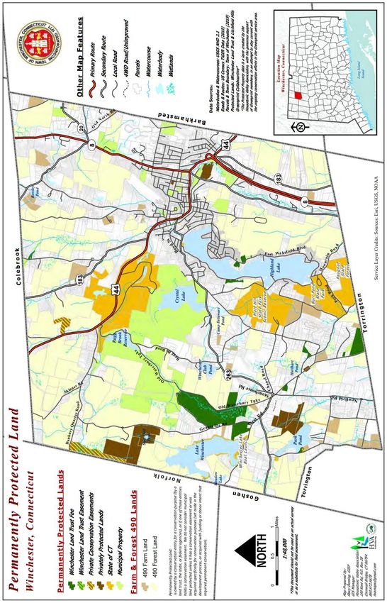
•   Providing of a range of housing including affordable housing, and ensuring that
          affordable housing is of appropriate quality, in appropriate locations, and
          appropriately served by and accessible to municipal services and amenities in the
          central area neighborhoods.
      •   Supporting the State in furtherance of its open space goals, providing protection for
          state assets such as DEP owned/managed water bodies and forest resources, and
          encouraging our citizens to further those goals in their own land management
          practices.

THE PLANNING PROCESS
The Subcommittee’s planning effort to identify local issues was interrupted in early 2020 due
to the COVID-19 pandemic. Nonetheless, they met remotely and prepared an inventory and
assessment of conditions and trends in Winchester. Based on these findings, the
Subcommittee discussed alternative policies and desirable future outcomes.

Public input continued to play an important role in preparing this Plan. The Subcommittee
sought input by:
   • Holding public meetings remotely, through ZOOM, the popular web-based video-
        conferencing platform, to collect input and discuss issues.
   • Carrying discussion of the POCD on every regular meeting agenda, twice monthly.
   • Holding public forums with residents to discuss the future of Winchester.
   • Encouraging the participation of local commissions and boards.

The goals and strategies in this Plan are a culmination of the research and analysis
conducted by the Subcommittee and public input and guidance.

The Planning and Zoning Commission has the statutory responsibility to adopt the POCD
and a lead role in overseeing its implementation. However, implementation will occur only
with the diligent efforts of the residents and officials of the Town. As a result, responsibility
for implementation rests with all boards, commissions, agencies, and individuals in
Winchester.

1-2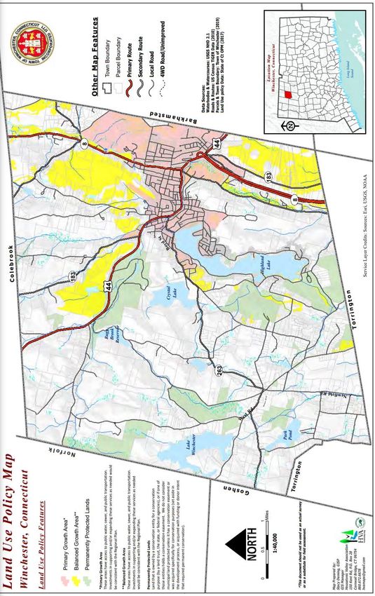
Winchester Plan of Conservation and Development 2021

OTHER PLANS AND SPECIAL STUDIES
In addition to our previous POCD, the Town has prepared a number of other plans and
studies which aided in preparing this plan.

These include:

Connecticut POCD
   • State of Connecticut Plan of Conservation and Development – 2013-2018
Erosion / Soil
   • Connecticut Guidelines for Erosion and Sediment Control, Connecticut Department of
       Environmental Protection – 2002.
   • Soil Survey of Litchfield County – US Department of Agriculture, Soil Conservation
       Service.
   • Natural Resources Inventory, 2009, prepared by the Conservation Commission
   • Corridor Study, Rowley Street / Torrington Road, 2008, prepared by TPA Design
       Group
   • Watershed Protection Study by LHCEO, 1990
   • Traffic Study Condo

                                                                                    1-3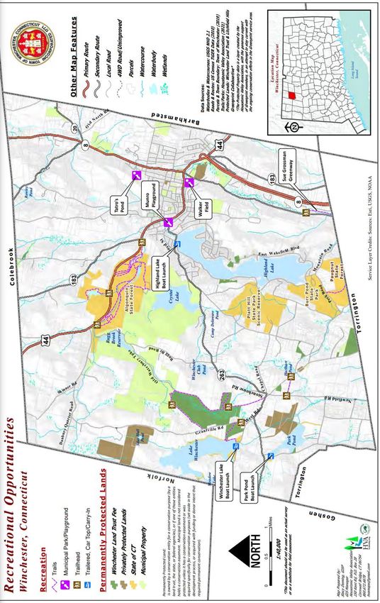
Winchester Plan of Conservation and Development 2021

2 – CONDITIONS AND TRENDS

A BRIEF HISTORY OF WINCHESTER
In the mid-1600s, the first English settlers came to the land which is now Winchester. Their
patterns of settlement and overall well-being were dictated by the nature of the land, as it
still is today. Favorable land conditions, which determined development potential, resulted
in Winchester Center being settled before what is today called Winsted.

During the nineteenth century, industrial growth took place along Winchester’s rivers to take
advantage of waterpower. During the twentieth century this industrial base dwindled leaving
Winchester, like so many other New England towns, reviewing their growth potential and re-
evaluating the vision for the community.

Two other factors played a
critical   role    in    shaping
Winchester’s        development
patterns: the 1955 Flood and
the Route 8 Expressway. The
1955 flood destroyed 170
retail stores and 90% of the
Town’s       industries      and
permanently changed the
Downtown.        The Downtown
was rebuilt with buildings on
only one side of Main Street
which         provides       the
opportunity for river access
and utilization.
                                    Photo from CT State Library.

The opening of the Route 8 Expressway improved access to jobs to the south. As a result,
more residents began working outside the community. Conversely, Winchester was now
more accessible to the region.     Winchester was also impacted by the loss of passenger rail
service to points south in 1958.

                                                                                         2-1
Winchester’s land conditions continue to play an important role today by influencing how the
land is, can, or should be used.
THE PEOPLE OF WINCHESTER
POPULATION CHANGE
Population Change, Winchester
Winchester was home to 10,604 in 2019, according to the
State of Connecticut Department of Public Health. The Town’s Year Pop. Change
population has fluctuated over the past 60 years, reaching a 1970 11,106 5.49%
peak of 11,542 people in 1990, then decreased slightly. 1980 10,841 -2.44%
Some of the decrease reflects changing family structures. 1990 11,542 6.47%
2000 10,664 -8.23%
2010 11,242 5.14%
2019 10,604 -6.02%
Population Projections
Non-resident weekenders add to Winchester’s population, but
Year Estimate Change
they are not accounted for in the Census. According to town
2030 10,833 1.20%
property records, about 15% of single-family homeowners
2040 11,964 1.20%
have a principal residence outside of Connecticut. This data
may indicate that Winchester has a fairly large influx of 2050 11,015 0.50%
seasonal / weekender residents whose effects on the town should be further assessed.
Overall, Winchester’s population is projected to grow slowly – about 1% per decade. Public
school enrollment has decreased from 942 in 2010 to 554 in 2019, a decrease of 41.2%,
according to the State of Connecticut Department of Education. Both the Winchester Board
of Education and the State have projected a continuation of modestly declining school
enrollment.
2-2Winchester Plan of Conservation and Development 2021
DYNAMICS OF POPULATION CHANGE
For planning purposes, age composition can be divided into three major age groups based
upon their differing needs or concerns: children (ages 0-19), adults (ages 20-54), and
mature residents (ages 55 and up). The following percentage distribution provides a sense
of the expected changes in age composition in Winchester.
Age Composition, 2000 to 2040, Winchester
ACTUAL PROJECTED
Ages 2000 2010 2020 2030 2035 2040
0-19 24.70% 24.70% 20.5% 21.08% 19.73% 19.31%
20-54 49.90% 46.50% 35.45% 36.53% 36.2% 35.38%
55+ 24.40% 28.80% 36.39% 37.87% 37.63% 37.72%
The following table summarizes projected changes to Winchester’s age composition and
possible implications.
Summary of Age Composition Projections, Winchester
Age
Description Needs Projection
Range
Infants 0 to 4 • Childcare Projected Slight (.25%) Decline
• School facilities
School-Age 5 to 19 • Recreation facilities Projected Decline of < 1%
• Recreation programs
• Rental housing
Continue to decline to 2030 and
Young Adults 20 to 34 • Starter homes
beyond
• Social destinations
• Family programs Slight increase to 2030, larger
Middle Adults 35 to 54
• Trade-up homes (2.5%) increase to 2040
• Smaller homes
Mature Adults 55 to 65 Projected Decline of 2.5%
• Second homes
• Tax relief
65 and
Retirement Age • Housing options Projected 4% Increase to 2030
over
• Elderly programs
2-3HOUSING
HOUSING UNITS AND HOUSEHOLD SIZE Housing Units, Winchester
The number of housing units in Winchester Year Housing Units Increase/Decrease
has increased since the 1970s except for a
1970 4,015 6%
slight decline from 1990 to 2000.
1980 4,511 11%
However, overall, the number of housing
1990 5,093 11%
units in town has increased significantly over
2000 4,922 -3%
the last fifty years or so, with the addition of
2008 5,169 5%
1,627 units or 41%.
2019 5,642 8.38%
Source: CERC Town Profile 2019
While the previous fifty years had seen a slow but steady decrease in the size of the average
Winchester household, this past decade a break in this long-running trend was observed.
This decade’s likely upturn in average household size
reflects several demographic trends. Household Sizes, Winchester
Nationally, a growing share of the population are Year Persons Per Household
residing in multigenerational family households. In 1970 2.77
2016, 20% of Americans lived in a multigenerational 1980 2.4
household, up from 12% in 1980. On average, these 1990 2.27
families have about two more members than other 2000 2.18
households. More Americans in the wake of the Great 2019 2.39
Recession are “doubled up” in shared living quarters. Source: 1970-2019 Census
This arrangement refers to the presence of an “extra
adult” in the household, who might be an adult child or parent of the householder, or simply
a roommate or boarder in the household.
HOUSING STOCK CHARACTERISTICS
Winchester’s housing stock is very diverse, Types of Housing Units
ranging from older mixed use and multi-family Type of Structure Unit
Town County State
homes in the Downtown to newer, more is Located In
expensive homes in the rural sections and on Mobile HomeWinchester Plan of Conservation and Development 2021
Sixty five percent of Winchester’s housing units were built Age of Housing Units
before 1960 and many of these older units are badly in
need of updates and repairs. This is of particular concern
in the Downtown.
P re-1960
65%
HOUSING PRICES AND AFFORDABILITY
Connecticut’s housing market showed signs of Housing Sales in Winchester
strength in 2019 as new permits reached their 2010, 2011, 2013, 2014, 2015, 2016, 2017
second highest level since 2007 and home sales Winchester County State
prices reached an eleven-year high. The demand for $400K 6.0% 14.5% 23.6%
multifamily units gained momentum over the past $300-400K 6.0% 14.4% 15.0%
decade. More than 49K total housing units were $200-300K 14.5% 26.3% 25.9%
authorized in Connecticut between 2010 and
$100-200K 56.3% 34.7% 27.6%
2019. The shift of housing choices can be partially
Under $100K 17.6% 9.9% 8.0%
attributed to the growth of transit-oriented
development, creating walkable urban environments that are seen as increasingly attractive
to millennials and baby boomers.
Despite this rapid increase, the average house in Winchester is still more affordable than
most of the average homes in Litchfield County or the State. A 2020 Warren Group study
identified Winchester as having the second lowest median housing value in Litchfield County.
Only neighboring Torrington had lower median housing prices. Data from the Connecticut
Data Collaborative indicates that over 70% of houses sold in Winchester were sold for less
than $200,000. Using standard measures of affordability, more than half of the houses
since 2010 sold at prices affordable to a household earning the Town’s median income of
$57,429. Having an affordably-priced housing stock provides an asset in the region.
Rentals appear to be fairly affordable, too. Based on Connecticut Economic Resource Center
(CERC) 2013 data, more than 50% of Winchester’s apartments rent for less than $1,000 per
month. These rents likely address the needs for low- and moderate-income families, but
there appears to be a gap in meeting the needs for median and upper income households.
2-5Median Housing Value for
Single Family Units, 2018
Compared to towns with similar housing market characteristics, a Winchester $146,750
significant number of homes did sell for over $400,000. These
Torrington $145,000
higher priced units likely reflect the attraction of Winchester’s lakes
Colebrook $176,000
and rural regions to more affluent second-home owners.
New Hartford $237,750
Barkhamsted $254,250
Connecticut General Statute, Section 8-30g requires that a
Litchfield $280,000
minimum of 10% of a community’s housing units be affordable to
Norfolk $355,000
households earning 80% or less of the Region’s or State’s median
Warren Group.
household income (whichever median is lower). The statute defines
“recognized affordable housing” as:
• subsidized housing,
• financed by CHFA or other mortgage assistance programs, or
• deed-restricted to affordable prices.
According to the Connecticut Department of State-Recognized Affordable Housing in
Economic and Community Development (DECD), Winchester
12.05% of Winchester’s housing meets this Year Units % of Housing
requirement. This means that Winchester is 2015 723 12.88%
exempt from an affordable housing appeals 2016 656 11.69%
process in which developers can override local 2017 678 12.082%
zoning. 2018 618 11.01%
2019 607 10.81%
The Winchester Housing Authority (WHA) 2020 609 10.857%
Source: CT DOH
manages the Town’s affordable housing units.
They have built 164 units of subsidized senior housing and they also manage the HUD rental
assistance program. Another 20 units of low-income housing have been built by the Winsted
Health Center and WHA is working on plans to add another 32 units of subsidized housing.
Winchester will be able to assess its housing needs in more detail as it develops its state
required Affordable Housing Plan.
HOUSING FOR THE SEASONAL POPULATION
The 2000 Census indicated that six percent of Winchester’s housing units are “occasional or
seasonal” compared to a state average of two percent. As noted earlier, a review of the
Town’s property records would suggest a much higher and growing number of
weekend/vacation homes, possibly in the 12 to 15% range. Many of the larger, newer and
higher value homes are owned by families with principal residences in other parts of the
State or Country. Of the ten highest valued homes, six are owned by non-Winchester
residents. There is clearly an attraction to Winchester’s lakes and scenic rural areas for more
affluent families who are looking for getaways.
Seasonal or occasional homes are a form of economic development in Winchester. They
generate need for contractors and caretakers and provide a fiscal benefit to the Town
2-6Winchester Plan of Conservation and Development 2021
because the tax revenues generated by these properties tend to exceed the costs for the
services (e.g., education costs). Moreover, people who can afford second homes likely spend
money in local establishments.
ECONOMIC CHARACTERISTICS
JOBS
In 2018, there were 6,131 jobs in Winchester, according to the Connecticut Department of
Labor. This represents a loss of approximately 419 jobs since 2010. Other Services (except
Public Administration) comprise the majority of business establishments
Types of Jobs in Winchester
% of % of
Establishments Jobs in
Business Sector in Town Town
Construction and Mining 7.1% 2.1%
Manufacturing 10.7% 24.8%
Retail Trade 11.9% 7.7%
Health Care and Social Assistance 9.5% 10.0%
Other Services (except Public 17.8% 6.4%
Administration)
CERC, 2018.
LABOR FORCE
According to the Connecticut Department of Labor, Winchester had a labor force of 6,131 in
2018, about the same level as 2009. About 4.5% of Winchester’s labor force is currently
unemployed. . The overall unemployment rate has been cut in half in ten years but is the
highest in Litchfield County, second only to Torrington. .
With a total of 3,225 jobs and 6,131 workers it is clear Winchester exports workers to
other communities.
Commuting Patterns, 2018
From Winchester to…. Into Winchester from...
Torrington 771 Winchester 670
New Hartford 310 Torrington 653
Hartford 225 New Hartford 105
North Canaan 121 Barkhamsted 62
Farmington 190 Harwinton 58
Waterbury 121
2-7TAX BASE
Historically, Winchester’s prosperity and economic momentum have been centered on the
industrial, commercial, and residential core of the Downtown. More recently, Downtown and
the High-Density Downtown Neighborhoods have faced many of the challenges also faced by
other older New England urban centers i.e., declining tax contributions, a larger rental
community, a smaller owner occupier population, older and smaller units, obsolete industrial
capacity, and a disproportionately smaller share of investment dollars.
The housing stock (in terms of condition and use) may play an important role in these issues.
Older units that are not well-maintained are of less value and, with a concentration of lower-
income households, rents may not financially justify updates and upgrades.
Examples of economic disparities between Downtown and the remainder of the Town
include:
• With over 60% of the population and housing units, Downtown represents just 38%
of the real estate tax base.
• The average taxpayer Downtown pays approximately $1,850 per housing unit in
annual property taxes, while the average taxpayer in the Lakes District and other
rural areas pays over $4,900 per year.
• Grand list growth in the Downtown lags other parts of Town. From 2001 to 2008,
growth averaged 7% Downtown while the growth in the outlying Lakes District and
other rural areas was nearly double (13.6%) and growth in the Highland Lake District
was even higher (20%).
• Since the 2007 town-wide revaluation, real estate prices Downtown have continued
to decline (down 7%) while outlying region values have continued to increase (up
6%).
• More than 80% of the recent residential construction spending took place in the
Rural and Lakes regions.
The following charts summarize these issues.
2-8Winchester Plan of Conservation and Development 2021
Real Estate Tax Base Average Property Tax
Annual $/Unit
$732M
$6,000
$4,936
Industrial, 26M $5,000
$4,000
$2,985
$3,000
Do wnto wn $1,850
282M $2,000
Rural & Lakes $1,000
424M
$0
Total Tow n Dow ntow n Rural & Lakes
Annual Grand List Grow th Real Estate Sales Trend
2001 - 2008 Since 2007 Revaluation
25% 8.0%
20% 5.8%
6.0%
20%
13.6% 4.0%
15%
2.0% -0.4%
9%
10% 7% 0.0%
5% -2.0% Total Tow n Dow ntow n Rural & Lakes
-4.0%
0%
Total Tow n Dow ntow n Rural & Highland -6.0%
Lakes Lake -8.0%
-7.2%
Note: “Highland Lake” is a subset of the “Rural & category.
Lakes”
2-9Zoning and Development Potential
The Town is divided into 8 zoning districts to regulate land uses. Prior to the 2016 Zoning
Regulations Revision, the town formerly had 21 zones with only 5%, or 1,060 acres, zoned
for business.
Existing Zoning
Zones
Town Single Family (TSF)
Town Center Residential (TCR)
Town Center (TC)
Town Gateway (TG)
Production and Innovation (PI)
Rural Residential (RR)
Highland Lake District (HLD)
Highland Lake Business District (HLBD)
There is considerable available land to support development for future population growth.
There is also potential for additional investment in developed properties, similar to that
occurring around Highland Lake. There is little vacant land in Downtown, but there is
significant redevelopment potential (e.g., unused mill space). Such redevelopment could add
residents, commercial uses, or a combination.
In the outlying areas, significant raw developable land exists even when accounting for
environmental constraints such as steep slopes and wetlands. A rough analysis of
development potential indicates that there are approximately 3,000 developable acres in
total, distributed as follows (acreages are approximate):
• Route 8 corridor – 500 acres
• North of Route 44 and west of Route 8 -- 1,000 acres
• South of Route 44 and west of Route 800 -- 1,500 acres.
Based on current zoning, this net developable land could theoretically support up to 2,500
additional households or an increase of almost 50% over today’s population. This
calculation does not account for residential redevelopment in the Downtown.
2-10Winchester Plan of Conservation and Development 2021
3 – COMMUNITY VIEWS AND VISION
COMMUNITY VIEWS
In preparing this Plan, it has been the goal of the POCD Subcommittee to reflect the
sentiments and values of the community garnered from public meetings, the efforts of
numerous boards, commissions, and committees, and from the many personal comments and
conversations that have contributed to the Subcommittee’s considerations.
Local boards and commissions provided input at a February 22, 2021 Planning and Zoning
Commission meeting after the Subcommittee held a public Saturday workshop on February
20, 2021.
Key issues and topics emerged at the meetings including the following:
• The Town is well managed, and residents enjoy and appreciate living here.
• Residents feel safe in their homes and secure in the knowledge that their friends,
neighbors, and local officials care about their well-being.
• The character and quality of Winchester is defined by its natural resources – they
must be preserved.
• Features such as ridgelines, stonewalls, and open space should be preserved.
• Water features and protecting critical watersheds are important.
• Rural areas should be preserved.
• In Downtown, rehabbing mill buildings, enhancing and improving the Mad River,
retaining historic architecture, and emphasizing mixed use development and market
rate housing are important.
• The Route 800 corridor presents opportunities for economic growth.
• Implementation of the POCD is important.
• Our downtown neighborhoods should be revitalized.
3-1VISION
A vision for Winchester’s future also emerged during the planning process. This vision sets
the framework for developing a set of challenging, yet achievable, goals. In the subsequent
chapters of this Plan, these goals will be defined along with strategies to achieve the goals.
A POCD is a work in progress. While the Planning and Zoning Commission has charted a
course, the community must make sure that course is followed in order to realize this vision.
Vision for Winchester
In Winchester, we will:
Cultivate the self-reliant spirit of our historic New England town;
Serve as a tourism, cultural and higher education hub;
Achieve a demographically balanced commercial center;
Nurture our neighborhoods surrounding the city center;
Respect the rural charm and natural beauty of the countryside;
Enhance our recreation opportunities; and
Encourage green practices and be a leader in the region.
To achieve our vision for viability and prosperity, we must strive to:
Provide the highest possible level of protection to our water and forest resources;
Emphasize open space preservation;
Revitalize our mixed-use Downtown, and anchor it with expanded retail and office space and a
range of housing;
Attract middle- and upper-income households to the Downtown and high-density downtown
neighborhoods in order to promote and maintain a balanced and diverse residential base and to
increase the customer base and activity level in the Downtown;
Promote a pattern of low-density residences in our rural areas; and
Anchor future development around existing patterns of development and infrastructure.
3-2Winchester Plan of Conservation and Development 2021
4 – PLANNING AREAS
For planning purposes, Winchester can be categorized into five geographic planning areas
(see map on page 4-2). While many strategies in this Plan are applicable town-wide, some
strategies respond to a particular challenge or opportunity in one of these planning areas.
The following pages identify each area and summarizes its key characteristics and primary
planning objectives. Specific strategies for these areas are found in the chapters that follow.
Lakes District Northern & Eastern Winchester
This area contains low-density single family residential
This area is comprised of low-density single family
development, and has generally retained its overwhelmingly
residential development with a rural, wooded and
rural, wooded and agrarian feel. It is expected that natural
agrarian feel. This area is home to many natural
resource constraints will ultimately decide development
assets that add significant value to the Town.
patterns and intensities.
Key Characteristics: Key Characteristics:
• Open space and recreational amenities
• Small scale farming
(Highland Lake, Winchester Lake, Park Pond)
• Drinking water supplies (Crystal Lake,
• Beautiful views
Rugg Brook Reservoir)
• Elevated terrain, punctuated by north-south
• Agricultural land
oriented stream valleys
• Remarkable diversity of topographical
features, biodiversity, animal habitat
• Cultural amenities such as historic
Winchester Center Green and other historic
resources, structures and landscapes
Planning Objectives: Planning Objectives:
• Maintain as a low density residential
• Preserve the natural features.
area.
• Enhanced protection of environmental
and recreational assets and ensuring their • Maintain as a low density residential area.
appropriate use.
• Maintenance and continue growth of the • In limited cases, areas of higher density residential
tax base by attracting and retaining residents and development might be appropriate if it fits in with the visual
tourists to this area. This population will help and topographical landscape, preserve significant amounts of
support Winchester’s commercial and fiscal needs open space, and attracts residents that will support
and stability. Downtown.
4-1Downtown High Density Downtown Neighborhoods
While this Plan does not intend to delineate
Downtown is an “industrial age” Main Street,
exact boundaries of the Downtown
with commercial uses, civic uses and
Neighborhoods, it is an area clearly centered on
apartments. It is in need of significant
Downtown and is currently served by public
redevelopment since many buildings are
water and sewer. This area is predominantly
outdated, functionally unusable and
residential, with some municipal and
aesthetically inappropriate.
commercial uses.
Key Characteristics: Key Characteristics:
• Predominantly nineteenth and first
• Mixed uses, civic hub
half twentieth century residential architecture
• The Mad River runs parallel to • Conversions of single-family houses
Main Street to multi-family
• Old manufacturing and mill • Strong presence of renters and
buildings transient population
• Beautiful architecture (particularly
• Little municipal green space
churches)
• Open spaces (East End Park, West
• Spectacular views
End park, river)
• Route 44
• Abundance of rental units Planning Objectives:
• Retain as a moderate to high density
residential core, with a range of housing types,
which will provide a customer base to
Downtown businesses.
• Increase homeownership to attract a
Planning Objectives:
range of income groups
• Promote and sustain a financially
viable, revitalized, mixed use, high density
• Integrate market and subsidized
Downtown that will serve as a commercial,
senior housing throughout the district; avoid
governmental, religious, educational and
concentrations.
cultural destination for residents of the Town,
surrounding towns and tourists.
• Integrate open space and • Develop neighborhood open spaces
environmental safeguards in redevelopment to create a sense of community
4-2Winchester Plan of Conservation and Development 2021
Route 8/800 Corridor
This area is a narrow corridor running from
south to north on the eastern extremity of the
Town. This area is home to longstanding
industrial uses.
Key Characteristics:
• Environmental challenges include:
flood plain along the Still and Mad rivers;
steep slopes and ridgelines along the western
and eastern boundaries; possible soil and
groundwater impairment due to history of
industrial use.
• The northern part has additional
space and is served by public water and sewer
service
• Existing land uses in the southern
part, which does not have water and sewer,
includes low density residential, vacant and /
or obsolete industrial and commercial
properties, small-scale commercial and
quarrying/processing operations.
Planning Objectives:
• In the northern portion, encourage
additional industrial and commercial
development.
• In the southern portion, in the
absence of sewer and water, encourage
recreational use. If utilities are provided,
determine opportunities.
• Improve aesthetics since the area
serves as a gateway to Downtown.
• Balance economic development
goals with protecting the natural character of
this area and the rivers.
4-34-4
Winchester Plan of Conservation and Development 2021

5 – GREEN PRINT FOR WINCHESTER
OVERVIEW

The Green Print is an all-encompassing term for Winchester’s creative land use planning and
a road map to a more environmentally and socially respectful method of development.
From the most pristine natural ecosystems to the most highly developed areas and
everywhere along the spectrum, the Green Print can play an important role in enhancing the
image, identity, and quality of life in the town.

The Green Print is an approach to overcome challenges such as a passive approach to
conservation in which conservation is mainly a function of a lack of development.

The Green Print intends to capitalize on assets. Assets include having progressive and
mindful land use commissions and property owners that have initiated conservation
measures.

The Green Print overarches the chapters in this POCD, which are organized around three
main themes:
   ▪ Conservation – those things that we must protect (natural resources, open space,
       community character, historic resources);
   ▪ Development – guiding future growth (community structure, residential development,
       business development); and
   ▪ Infrastructure – supporting our community (community facilities, transportation,
       utilities).

The Green Print approach applies to what we want to protect, influences how and where we
develop, and its principles affect how we think about our infrastructure. Therefore, it is
important to introduce Green Print strategies related to conservation, development, and
infrastructure.

GREEN PRINT STRATEGIES
The Green Print is simply an all-encompassing term for Winchester’s creative overall land use
planning, a road map to a more environmentally and socially respectful method of
development. The intent of the Green Print is to be a symbiotic integration of conservation
and development where both are seen as the black or white of a black and white photo,
neither being visible except in the presence of the other.

                                                                                         5-1
The Green Print provides a proactive approach that focuses on development in response to
clearly stated conservation and development goals as well as the town planning areas.
Land use boards will actively review development applications regarding their
appropriateness and synchronicity with conservation goals for the particular planning area.
Land use boards will condition permits based the Green Print concept. Therefore, the Green
Print will play an Integral role in enhancing the image, identity, and quality of life in the town
of Winchester.
The Green Print approach involves the following:
• Encouraging a change in mindset to one that values the environment and respects
the interconnectedness of human activities and quality of life for citizens as well as
the ecosystems of Winchester. The Town could organize a Green Print committee to
guide land use boards and commissions. Education of the community, developers
and the town will play a central role in success.
• Creating a Green Print brand and identity for the town to distinguish it from others in
northwest Connecticut and attract new residents who are interested in Green Print
approaches.
• Becoming a successful demonstration community for voluntary acceptance and
implementation of progressive green practices e.g., LID, BMP, RoHS, LEED, Eco-,
Green, Sustainable and Permaculture (See Glossary in Appendix A). These practices
should be implemented throughout the entire development process, from planning
and design through construction and maintenance.
5-2Winchester Plan of Conservation and Development 2021
• Balancing very long-term thinking for all conservation and development activities
with experimentation and innovation. For example, attention must be paid to how
development activities might impact opportunities on different sites or future
development of the same site.
• Maintaining and expanding on the State’s principles of Smart Growth, which entail
redevelopment and revitalization of commercial centers, expanding housing
opportunities, concentrating development around transportation nodes and corridors,
conservation and environmental protection, and integrating planning efforts with all
levels of government.
• Ensuring that all development is minimally invasive, from the varied perspectives of
functional, visual, and environmental impact on our natural and cultural resources,
including but not limited to energy, night skies, quiet and air, soil and water quality.
The Town should develop an appropriate check list of Green Print parameters to be
considered for all conservation and development activities.
• Preparing implementation guidelines to assist politicians and land use
commissioners, citizens, and developers in raising the social and ecological bar by
assimilating the Green Print into a user-friendly document.
Many additional actions to implement the Green Print, such as walkability and energy
conservation, are found in the following chapters of this POCD.
5-35-4
Winchester Plan of Conservation and Development 2021
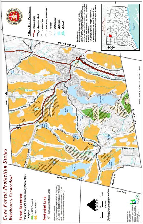
6 – CONSERVATION
The identification of natural and cultural resources that ought to be protected is an important
component of a Plan of Conservation and Development. Determining which features are
important from an ecological perspective, for preserving character and for enhancing overall
quality of life, sets the framework for discussions about future growth in Winchester. Chapter
5, Green Print, provided overarching themes that also relate to conservation.
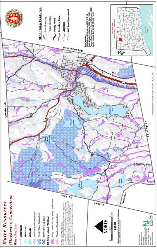
NATURAL RESOURCES
OVERVIEW
The Natural Resource Inventory Report identifies in detail the natural resources and functions
that should be preserved or conserved. These resources can be summarized as:
Resources for Preservation: Resources for Conservation:
Resources so important to environmental Resources with important functions that can
quality or community character that be maintained while compatible activities
alterations to these areas should be take place nearby if development occurs in
avoided to the extent feasible and prudent. an environmentally sensitive way.
• Sensitive watershed areas (such as
• Watercourses and Water Bodies
Highland Lake or public water
(water quantity and quality)
supply watersheds)
• Inland Wetlands • Streambelt buffer areas
• Stratified drift aquifers and areas of
• Steep slopes (>25%)
high groundwater availability
• Flood Plain (100 year) • Unique or special habitat areas
• Flood Plain (500 year)
6-1ISSUES AND CHALLENGES IN EACH PLANNING AREA Lakes District While water bodies are located throughout town, the preponderance is within the lakes district. Topographically, this area has significant limitations on development due to steep slopes, wetlands, and other poorly drained soils and shallow soil to bedrock characteristics. The current density of housing and use of these water bodies has created serious environmental and public safety risks. There is a negative impact on water quality with tree cutting for residential development and roads that create impervious surfaces and consequent storm water runoff and management problems. Both Highland Lake and Park Pond have invasive aquatic plants that require costly intervention to control and mitigate. The State of Connecticut Department of Energy and Environmental Protection notes that watershed management as a term used to describe the process of implementing land use practices and water management practices to protect and improve the quality of the water and other natural resources within a watershed by managing the use of those land and water resources in a comprehensive manner. The 1990 Regional Watershed Protection Study, conducted by the Litchfield Hills Council of Elected Officials, offered a number of recommendations for the Lakes District. Recommendations included increasing minimum lot sizes, incorporating a “net lot size structure” (excluding from minimum lot sizes undevelopable land), limiting impervious coverage, and limiting timber cutting practices to “sustainable timber farming.” Northern and Eastern Winchester There are significant limitations to development in this area due to steep slopes, shallow soil to bedrock characteristics, and high seasonal ground water levels. While there are no areas of significant wetlands or significant water bodies, this area does drain to the Mad River and Still River. Downtown and High-Density Downtown Neighborhoods Challenges in these areas relate to storm runoff. More developed areas have a greater proportion of impervious surfaces. Storm water generally runs directly into drainage pipes or directly into water bodies, carrying pollutants. Route 8 / 800 Corridor The Mad and Still Rivers, and their associated floodplains, run through this area. The western and eastern boundaries are characterized by steep slopes. Historic industrial activity also may have impaired groundwater here. 6-2
Winchester Plan of Conservation and Development 2021

STRATEGIES TO PROTECT NATURAL RESOURCES
A primary goal of this Plan is to
protect our natural systems in
order to preserve community
character, preserve environmental
functions, and enhance the quality
of life for residents. Of utmost
importance is the protection of our
water bodies. Our lakes, rivers,
ponds, streams, and springs are
valuable natural resources that
contribute significantly to the
financial, recreational, and aesthetic
viability of the Town.

When discussing natural resource
protection     strategies,  it    is
important to note that many
existing parcel boundaries are the
result of history. The right to use
land is the economic and legal
right of property owners.

Where      Feasible,    Preserve
Sensitive Areas as Open Space
Permanent protection of land as
open space affords the strongest
protection   for many natural
resources.       Where      feasible,
Winchester should continue to encourage the permanent protection of sensitive natural
resource areas through conservation easements, private donations of property to land trusts,
open space set asides in new developments, and by other appropriate means (See Open
Space chapter for detailed strategies).

Update Density and Minimum Lot Size Requirements
Many communities find that the overall zoning framework, adopted many decades ago, may
not adequately address today’s needs. The Town has recently amended sections of the
zoning regulations to address emerging challenges and incorporated modern tools in order
to better protect the land, environment, and overall quality of life. Future revisions should
ensure that development is appropriate in form, function, and impact with the underlying
land.

                                                                                         6-3
Address Storm Water Runoff
A key environmental goal of all development should be to minimize the amount of run-off
and improve its quality, such as sedimentation, acidity, temperature, etc. There are a number
of steps that can be taken to address run-off issues. From a regulatory approach, the Town
could require run-off volumes after development to be no greater than the volume before
development. This approach could apply only in sensitive areas, such as near wetlands, or
only for certain types of developments, such as for new subdivisions. Elsewhere, regulations
could set limits on the increase in run-off.
Reducing impervious surfaces increases on-site infiltration of stormwater, thereby reducing
run-off. Additional drainage strategies might include requiring pervious material for
driveways within the setback or limiting impervious cover of all types. Limitations might be
most relevant in two planning areas:
• In the Lakes District, a limit of 10% of the net area or proportionate limit in large
parcels is recommended per current protective theory.
• In the Northern and Eastern Area, subdivisions should be limited to a maximum of
7.5% impervious coverage unless it can be demonstrated that a larger coverage will
be designed so as to result in zero incremental run-off.
Vegetated areas reduce the flow of runoff and help filter out pollutants. Expanding the width
of riparian buffers, adopting more restrictive limits on clear-cutting, and requiring that
buffers be appropriately planted can help reduce impacts to wetlands from runoff.
Drainage from unpaved town roads onto private properties has been an issue in Town. The
Town should create maintenance plans for its unpaved roads to help solve drainage issues.
Finally, most of these strategies can be achieved by implementing Low Impact
Design/Development (LID), which provides alternative storm water control methods. Land
Use commissions could require applicants to use LID techniques. LID can also be employed
in more developed areas where impervious surfaces are predominant, such as downtown.
Examples that could be employed downtown include using pavers rather than asphalt or
concrete and aligning tree basins with storm drains. An analysis of steep slopes and storm
drains downtown can help determine appropriate LID measures.
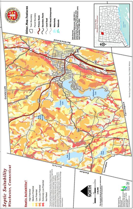
Reduce Water Pollution
In recent years, water quality protection efforts throughout the nation have focused on
reducing “non-point” pollution, or pollution that does not originate from a specific point.
This includes storm drainage discharges, lawn fertilizer, septic systems, agricultural runoff,
and similar sources. Implementing and updating recommendations made in the Crystal Lake-
Rugg Brook Reservoirs Watershed Protection Study to help the Town assess water pollution
risks and develop specific approaches to minimize risks.
Although there has been no indication of widespread septic failures or problems in
Winchester, improperly operating septic systems are a potential threat to water quality and
6-4Winchester Plan of Conservation and Development 2021
public health. Winchester should encourage programs to educate property owners about
proper septic operation and maintenance. Within the Lakes District, the Town could adopt
an ordinance requiring regular septic pumping. Such a program should take differences in
system design, soil types, and usage into consideration.
Reducing runoff, as discussed above, will also help minimize the amount of pollution that
reaches the Town’s water bodies.
The Town should continue to support a regular water quality testing program for key water
bodies. Testing provides advance warning of potential contamination threats to surface
water and aquifers and provides benchmarks for measuring progress. Monitoring is
important for the Mad and Still Rivers; a plan for remedial action and long-term management
plan should be developed.
Continue to Address Erosion and Sediment Control
Erosion and sediment controls are required in all new developments in Winchester.
However, adequate inspection and maintenance is necessary to ensure appropriate
protection of water resources. Careful inspection and maintenance should be continued until
areas are completely stabilized.
Environmentally sensitive areas such as wetlands, steep slopes, and floodplains are less
capable of supporting development than dry, flat land, yet are often treated equally in many
regulations. Development in and around these sensitive areas can lead to increased erosion
and flooding as well as biodiversity and property loss.
In the Lakes District, unpaved driveways and roads leading to Highland Lake and Park Pond
perimeter roads are subject to erosion. Methods of controlling erosion and reducing runoff,
particularly in areas with steep slopes, should be explored and implemented as soon as
possible. Future consideration should include requiring development proposals address the
“first flush” of runoff in that it be appropriately treated in terms of quality and rate of runoff.
In reviewing proposed development, commissioners should encourage site designs that
minimize impervious surfaces, promote infiltration of stormwater, and reduce runoff. Site
designs should continue to provide vegetative buffers to wetland and watercourses to filter
pollutants and protect them from direct receipt of runoff. The Inland Wetlands and
Watercourses Commission should consider requiring vegetative buffers surrounding Highland
Lake to filter pollutants and protect it from direct receipt of runoff.
Provide Public Education
The Town should undertake an educational program so that:
• Winchester’s residents will appreciate the value of the Town’s natural resources,
including benefits related to quality of life and property values;
• Property owners understand how their own individual actions can impact natural
resources and how they can minimize their impact; and
6-5• the Town and the Town’s commissioners are provided with information that could be
employed to protect natural resources, thereby building support.
Public education and involvement are particularly important for protecting water quality in
the Lakes District. Specific topics that could be addressed include: reducing or eliminating
sediment runoff, septic maintenance, hazardous materials, lawn and garden
fertilizers/chemicals, yard composting, clear-cutting and clearing of understory, wetlands
protection and similar issues. The Conservation Commission could take the lead on
implementing these programs.
Reaching out to youth and existing civic groups can be an effective way of educating
residents. The Town could encourage development of age-appropriate curriculum in
Winchester’s schools, from kindergarten through community college, that will enhance
knowledge of and appreciation for our natural resources.
Continue to Identify Natural Resources and Priority Protection Areas
The Natural Resources Inventory provides a wealth of information about natural resources in
Winchester. Maintaining and expanding the inventory should be an ongoing effort. Specific
additions to the inventory should include:
• Ecosystems within the Lakes District and trans-boundary systems;
• Additional natural resources such as vernal pools;
• Wildlife and vegetation including Federal, State, and local endangered and
threatened species; and
• Significant environmental features that need greater protection within the downtown
such as the Mad and Still Rivers, Highland Lake outflow, etc.
The Natural Resources Inventory can be a valuable tool for Town boards and commissions.
The Inland Wetlands and Watercourses Commission, the Planning and Zoning Commission,
and Zoning Board of Appeals could be required to make specific reference to the Natural
Resource Inventory when deciding on land use applications involving any water body. To
facilitate this process, the application form could include a statement that addresses water
body protection.
The Conservation Commission should be encouraged to undertake landscape-scale
ecosystem planning by creating conservation overlays. The overlays would identify priority
areas for protection such as ridgelines or significant tracts of large, unfragmented forest.
Work Regionally to Protect Natural Resources
Natural resources do not respect town boundaries; continued regional cooperation will be
important. The Town should promote collaboration with surrounding towns on studies of
trans-boundary ecosystems and create an inter-municipal agreement that states the values of
the resources and includes a formal commitment to work together to achieve planning and
protection goals.
6-6Winchester Plan of Conservation and Development 2021
Coordination with abutting towns is particularly important for any activity in the Lakes
District watershed to ensure protection and enhancement of the mutual watershed. (See
LHCEO 1990 Watershed Protection Study).
Address Invasive Species
Actions to address invasive species might include developing an Invasive Species Plan,
developing a process for eradicating invasive plantings, and discouraging the introduction
and storage of non-local organic material, such as wood piles, that may harbor invasive flora
and fauna.
Invasive species can cause tremendous harm to water bodies. The Town should examine the
process, financial and legal implications of steam cleaning watercraft prior to launching them
in the Town’s water bodies to curb the spread of invasive aquatic plants and wildlife such as
zebra mussels.
Additional Regulatory Strategies
• In the Lakes District, adopt watershed zoning that will expand the area of protection
(e.g., wider streamside buffers and greater distance from water body perimeter under
IWWC regulation). The zoning should incorporate best management practices
particularly for impervious surface, soil erosion prevention, and potential phosphate
loading.
• Create a Watershed Protection Ordinance that would address all aspects of
watershed protection including allowable uses of shoreline, shoreline buffers, extent
of the protected area, construction parameters, lot requirements, alteration of
vegetation, storm water and phosphate loading impacts, and enforcement.
• The enforcement of existing and any new regulations is important.
• Ensure that variances are granted in very few instances and not based on past
precedent, financial hardship, or legal threats.
• In the Lakes District, require restoration of indigenous, native comparable foliage
coverage prior to rebuilding or alteration of existing structures.
Additional Strategies
The following additional strategies can help protect natural resources in Winchester:
• Create and adopt standards of techniques to assess biodiversity when land-use
commissions request natural resource information from an applicant. An example
would be evaluation of the time of the year to conduct studies and sampling
requirements on stream beds and vernal pools.
• Provide for monitoring and intervention where conservation easements or restrictions
are used (e.g., selective harvesting under the direction of a State licensed forester).
• Create incentives for property owners to maintain undeveloped land in an
unfragmented state.
• Develop an Aquifer Protection Plan based on Connecticut Department of Energy and
Environmental Protection standards.
6-7OPEN SPACE
OVERVIEW
Preserving meaningful open space will help conserve important natural resources, protect
wildlife habitat, create more environmentally sensitive development patterns, provide fiscal
benefits, protect community character, and enhance the quality of life for Winchester’s
residents. Open space preservation is widely regarded as the most effective tool to manage
growth and maintain community character. Winchester residents have identified preserving
open space as a planning priority.
Open Space Types A focus on increasing Open Space acreage also functions to brand
From an open space us as a forward-looking community that is an active and responsible
planning perspective, steward of our natural, cultural, and recreational heritage.
experience has shown
that open space
generally falls into four Preserving more open space is an important component of
categories. protecting Winchester’s community character and quality of life. This
can be accomplished through two basic approaches: regulation and
Dedicated Open Space acquisition.
Land preserved in
perpetuity as open
space, often with public DEDICATED OPEN SPACE Dedicated Open Space in Winchester
use. VS MANAGED OPEN SPACE % of
Just over 16% of Winchester’s Owner Acres Town
Managed Open Space
19,499 acres is “Dedicated Town of Winchester 1,475 7.6
Land set aside for some
other purpose, such as Open Space”. This means that State of Connecticut 1,343 6.9
a golf course or public the land is considered to be Land Trusts 360 1.8
watershed land that permanently protected from Total 3,178 16.3
provides some open
development. It includes land owned by the State and land trusts,
space value. Public use
may not always be since they rarely sell land, they have acquired. The majority of the
allowed. Town-owned dedicated open space land surrounds Crystal Lake and
Rugg Brook reservoir.
Protected Open Space
Land protected from
development, such as a Another 42% of land in Winchester is considered “Managed Open
conservation easement, Space.” This is land that provides open space benefits today, but
but public use may not they can be developed at any time in the future. In other words,
be allowed. they are not Managed Open Space in Winchester
Perceived Open Space permanently protected % of
Land that looks or feels as open space. Most of Owner Acres Town
open, such as a fallow the Town’s Managed PA 490 Forest 7,103 36.4
farm or private Open Space is land PA490 Farmland 808 4.1
woodlands, but is not Other 281 1.4
preserved as open enrolled in the Public
Total 8,192 41.9
space. Act 490 Forest or
Farmland program. Owners receive a tax reduction when they agree
to maintain their land as forest or farm, but they can develop the
6-8You can also read


