Transformation of built cultural heritage in old Saigon (Ho Chi Minh City), Vietnam
←
→
Page content transcription
If your browser does not render page correctly, please read the page content below

IOP Conference Series: Materials Science and Engineering

PAPER • OPEN ACCESS

Transformation of built cultural heritage in old Saigon (Ho Chi Minh City),
Vietnam
To cite this article: Ngo Minh Hung 2020 IOP Conf. Ser.: Mater. Sci. Eng. 949 012052

View the article online for updates and enhancements.

                               This content was downloaded from IP address 46.4.80.155 on 09/09/2021 at 00:34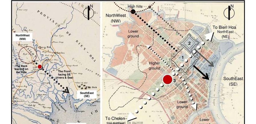
HERITECH 2020                                                                              IOP Publishing
IOP Conf. Series: Materials Science and Engineering 949 (2020) 012052 doi:10.1088/1757-899X/949/1/012052

      Transformation of built cultural heritage in old Saigon (Ho
      Chi Minh City), Vietnam

                         Ngo Minh Hung

                         Ph.D., General Director, Institute of Cultural Heritage and Development Studies
                         Head, International Cooperation and Scientific Research Department, Van Lang
                         University, Ho Chi Minh City, Vietnam

                         Email: ngominhhung@vanlanguni.edu.vn, hungnm_vn@yahoo.com

                         Abstract. Saigon was founded by the army commander Nguyen Huu Canh in the
                         seventeenth century. It became the capital of the French colony of Cochin-China in
                         1883, part of French Indochinese Union which lasted until 1945, and the capital of the
                         Republic of Vietnam (South Vietnam) until 1975. It has diverse cultural characteristics
                         and a unique urban form. It was described as 'the pearl of the Far East' during the 19th
                         and 20th centuries. After the unification of North and South Vietnam in 1975, Saigon
                         was renamed Ho Chi Minh City (HCMC). The economic reform process, Doi Moi,
                         which started in the late 1986s, transformed Vietnam from a highly centralized planned
                         economy to a socialist-oriented market economy, and its cities, HCMC included,
                         underwent significant new development. This paper aims to re-understand the nature of
                         old Saigon’s establishment and identity to authentically consolidate new findings of the
                         spatial development axis; re-assess the cultural significance of remaining places, which
                         are needed to support the coming Master plan period 2040-2060 of HCMC towards
                         sustainable conservation in a globalization context.

          Keywords: Saigon transition, spiritual axis, twin-cities

      1. Introduction
      The rapid transformation of HCMC’s economy in the last two decades is one of the success stories of
      Asia. The transformation of this economic center brought about tangible and intangible cultural changes
      in central places. Consequently, old urban artifacts and fabric, which represented the distinctive cultural
      and architectural identities of the Vietnamese, Khmer, Cham, Chinese, French, and Indians, are being
      replaced with more gigantic modern glass skyscrapers.
          A local Vietnamese scholar, Le Quang Ninh [1], has provided clear evidence that one consequence
      of the phenomenon of rapid modernization in the central districts has been that HCMC has lost about
      30% of its total 108 registered architectural heritage items since 1993 and 18 significant heritages of
      Saigon as well [2]. For instance, over hundred-year-old factories along Tau Hu canal and Tran Van Kieu
      street and at the old Binh Dong quay while ancient shop-houses in Ben Thanh area were demolished in
      2014 for redevelopment projects. Three conservation plans have been drawn up in the past, such as
      central HCMC’s architecture (1995) and Cholon town (2012); adjusted master plan (zone ZV-7) of

              Content from this work may be used under the terms of the Creative Commons Attribution 3.0 licence. Any further distribution
              of this work must maintain attribution to the author(s) and the title of the work, journal citation and DOI.
Published under licence by IOP Publishing Ltd                          1
HERITECH 2020                                                                              IOP Publishing
IOP Conf. Series: Materials Science and Engineering 949 (2020) 012052 doi:10.1088/1757-899X/949/1/012052

    central area (930 hectares) in 2019, but these have not led to conservation projects to protect ‘the spirit'
    of Saigon, which had been considered as the original city in the past of HCMC. Dealing with this issue
    requires an action must be taken immediately to protect Ho Chi Minh City’s surviving built heritage.
    The city is in a dilemma about how to preserve the spirit of Saigon. End of 2012, the local scholars (Le
    Quang Ninh, Nguyen Thi Hau, and Nguyen Ngoc Dung) discussed conservation of the city’s built
    heritage [3] must begin oldest long- ways (đường thiên lý) and its townscape, nostalgia-driven
    reinvention and unique cultural identity with particular area reflecting Saigon memory, Saigon River
    and Saigon market.
        There are many opportunities in the Asian Century [4] for enriching the city’s local culture, which is
    a resource of Asian symbolic significance made by the uniqueness of the well-planned French colonial
    city, old Western and tropical architecture initiated since the seventeenth century in Indochina. In this
    century, HCMC has a clear plan to become a sustainable city development with potentialities of
    preserving its cultural heritage and economic growth for a civil and modern city of southern Vietnam
    and an industrial, service and scientific center of Asia, an international center of tourism, finance,
    commerce, logistic service to 2040 and vision 2060 (at the document No. 91/BXD-QHDT of Vietnam
    Ministry of Construction that was submitted to the Prime Minister in 16th January 2019). Therefore, it
    needs to do more than this to respond to the rapid changes occurring in the HCMC’s historic core, which
    is re-understand and re-assess potential factors gained from historical Saigon and its transition to
    different hierarchy, areas, and levels in managing and conserving the local relics.

    2. Historical Saigon and its transition

    2.1. First initiation of Saigon
    The history, at first, showed the early presence of the Chinese in the ancient area of the Khmer by the
    existence of Phung Son Pagoda renamed from Funan temple built before 1000. The scholars, secondly,
    indicated it had been initiated from a Khmer village of Baigaur featured fishing and trading
    characteristics of the market town of Prey Nokor under Khmer Empire during the 10th- 11th century
    (period 1000- 1145). The area, on the one hand, had attracted more trader, mainly Vietnamese, by 1620
    [5] to carry out commerce of agricultural products at the ports. To foster the trading activity, Khmer
    King- Chay Chettha II [6] established two custom posts for Vietnamese located closely to Tan Binh
    River (old name of present Saigon River) and Saigon arroyo (previous name of current Thi Nghe arroyo)
    in the East of Prey Nokor. The first post was located in the Ben Nghe region, called Ben Nghe post (now
    Thai Binh market). The second post was placed in Saigon region, called Saigon post in the Chinese area.
    A number of Vietnamese, with the background of soldier-peasants, moved to the region as the land of
    refuge in the seventeenth century [7] and rapidly increased afterward.
        Typologically, the Ben Nghe post was highlighted, by the local scholars, on higher-area and at central
    point between Ben Nghe port (the East)- a confluence of Tan Binh River and Saigon arroyo and Dieu
    Khien Market (the West) and Saigon arroyo (the South) as primary point of the early city towards first
    form of commerce- port city. The Saigon post, located about nearly four km away compared to the first
    post, in the west to shape another town center of Tan Thuan region (the East). There were two old
    pagodas (Cay Mai and Phung Son) of Viet and Chinese built and existed until today. It was defined as
    a center of pure commerce and religion with the Chinese majority towards second form of trading and
    religious town in the regions. Both single forms had likely been an important trading center in the
    Mekong Delta region. In other words, economic activity was necessary in these towns’ foundation [7].
    In this period, French also marked their visits by erecting religious buildings, such as the first southern
    Bishop’s Palace (1659) on higher-area (now district 1 of HCMC).

    2.2. Second phase: the Viet localized Gia Dinh in Gia Dinh period (1698-1860)
    In 1788, the Southern region was re-organized and centralized, under feudal lord Nguyen Anh, to
    become the southern administration. This land played a role of the main port in the South with the posts

                                                          2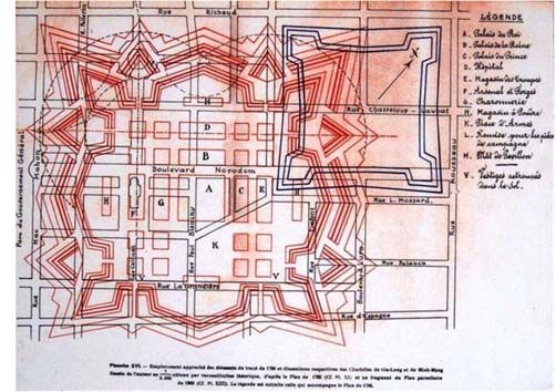
HERITECH 2020                                                                              IOP Publishing
IOP Conf. Series: Materials Science and Engineering 949 (2020) 012052 doi:10.1088/1757-899X/949/1/012052

    of Ca Tre and Vam Co along the Tan Binh River, together with Cau Kho sub-port on Saigon arroyo to
    control the goods that arrived and were shipped out.
        Later, the army commander Nguyen Huu Canh, in 1836, was sent to pacify land of Gia Dinh, which
    had previously been selected by Gia Long-first Emperor of the Nguyen dynasty. In terms of
    administration, Gia Dinh region covered about around 260.000 hectares of land and was descriptive as
    a water and cool climate city. Gia Dinh land- the Imperial City was the land (phủ Gia Định) covered
    entire the South. At the same time, the rural area belonged to two provinces Tran Bien and Phien Tran,
    being managed by the commander Canh of the Nguyen dynasty associated with the feudal institution,
    which applied over the administration, social-economic aspect, etc.
        The Gia Dinh region was next naturally localized by Viet people after the market town Baigaur was
    taken over in 1698. It was gradually coming to be called Saigon. Since there, the Saigon is a considerably
    initiative form of Vietnamese feudal city in the east. The region, based on the commercial initiative
    forms, grew and developed to become Saigon (mainly Vietnamese) and Cholon (predominantly
    Chinese). According to the map 1815, Saigon was one of the towns with rice- field, cemetery, and
    scattered hamlets in the center.
        The City was well protected by two fundamental systems: firstly, the Ban Bich rampart, built-in
    1772, ranging from the North to the West; secondly, Tan Binh River and Ben Nghe (Buffalo Quay)
    arroyo to separate the city to rural area. The region and cities being structured and well connected by
    two oldest long-ways (1) East-West way (now Nguyen Trai road), built in 1748 under Nguyen dynasty
    [8], connecting Saigon to Hue and My Tho; (2) North- South road (now Cach Mang Thang Tam road)
    linking Saigon to Cao Mien (the map 1623-1679); and canal of horse bowel (Ruot Ngua) made in 1772.
    Administratively, the boundary of the City had been changed sometimes. For instance, it was belonged
    to two provinces: Bien Hoa and Phien An in 1808 and again re-adjusted into Bien Hoa and Gia Dinh
    provinces after 1836.

    2.3. Third stage of Saigon City:
    In 4 Feb 1790, Gia Long- the first Emperor of Nguyen dynasty, who was inspired by military art of
    French fortification, ordered to build Bat Quai citadel (eight Trigrams, Vauban form [8], designed by
    Oliver de Puymanuel and Le Brun). It, built before the Hue Capital Citadel, was positioned on the High-
    ground surrounded by Tan Binh River (East), Thi Nghe arroyo (North), Ben Nghe arroyo (South) and
    oldest way of thousand miles (West). Regarding topological analysis on the maps, this provides clear
    evidence of the unique location of the citadel, following principles of Feng-Shui and the Book of
    Changes [9] in planning the master layout. Notably, the citadel faced Tan Binh river (now Saigon River)
    in front in Southeast (SE direction) towards Eastern sea and relied on the range of hill knolls (now Go
    Vap) in Northwest (NW direction) and a remote part of the Annamite Mountain Range (dãy Trường
    Sơn). On the one hand, it appears the citadel erected to stick close on such direction Southeast-Northwest
    forming Spiritual Axis that had been meaningfully determined by Viet’s ancestor and the founder of Gia
    Dinh residence as called in the south. On the other hand, the main axes of the citadel, running Northeast-
    Southwest and Northwest- Southwest, were identified by local ‘climate orientation’ [10] as considerably
    as controlling factor for later French urban form and street alignment of Saigon. Generally speaking,
    the citadel establishment was traditional and standard integration of ‘Thiên thời-Địa lợi-Nhân hòa’
    (clement weather, favorably terrain and concord among the people) accordingly.
        Moreover, the citadel had been named by different terms, such as Phien An, Qui (Turtle shape) and
    Saigon, Uy, to present its feature of an Imperial City, which currently bounded between four streets:
    Dinh Tien Hoang (East), Nam Ky Khoi Nghia (West), Le Thanh Ton (South) and Nguyen Dinh Chieu
    (North) of District 1, HCMC. There were storages of gunpowder, rice, and weapon, Royal step-over
    place (for the King's visit and stay), military governor palace placed within the citadel that was the
    military symbol of the imperial administration [7].
        Interestingly, the citadel had been depicted as the military city and also became the Governor-
    General's residence, which proclaimed the unique vernacular architecture of the South. The inner space
    was low-rise buildings variously functioned: domestic offices, apartment, business, for the use of the

                                                         3
HERITECH 2020                                                                              IOP Publishing
IOP Conf. Series: Materials Science and Engineering 949 (2020) 012052 doi:10.1088/1757-899X/949/1/012052

    king and royal family, upon square layouts with roofs covered by glazed tile and ornamented with
    dragons, constructed by brick; with verandas enclosed with a screen of matting [11]. The buildings had
    been laid on the foundation of brick and could be accessible by wooden staircase. Another building form
    was bungalow with good light and ventilation by using local and environmental- friendly materials, for
    instance: bamboo in general and being roofed with thatch in particular.
        Outside was residential area expanded on Lower-ground surrounding the citadel and naval arsenal to
    Tan Binh River and the arroyo of Thi Nghe and Ben Nghe; the oldest way of thousand miles (now Cach
    Mang Thang Tam road). Its residential structure constructed to follow grid-network that proved strong
    influence of European modern urban form and well connected the citadel with rivers’ banks and ports
    by the straight roads (now Dong Khoi, Hai Ba Trung, Nguyen Thi Minh Khai and etc). The scholar
    figured out that the population was dense near the river [11]. In parallel, the local architecture of the
    functional areas seemed quite temporary and straightforward factually. The majority of the house was
    one story made by wood, palm leaves, or rice straw roof to ordinary people downwards. Otherwise,
    several brick and tiled houses were built for the higher classes.

              Figure 1. Oriental and topological analysis of the Citadels and French development.
                                      Source: The author's findings (2020)
        Nevertheless, the bustling trade activity was focally happening at the Ben Thanh (Quay near the
    citadel) market and Ben Nghe harbor at Tan Binh river and Ben Nghe arroyo. This area was highlighted
    as the most significant trading center in the South with such famous markets, for example (1) old Ben
    Nghe located at current street corner of Dong Khoi and Nguyen Hue; (2) Da Com in front of the August
    Museum (now Cach Mang Thang Tam); (3) first Ben Thanh closed to Saigon river (now National
    treasure building); (4) Soi was opposite the Nha Rong building at the confluence and; (4) Tan Kieng
    established near Cho Quan church and etc. Moreover, surrounding hamlets and villages had their own
    specialized commercial and trade shops consistent with the tradition of the time. For these reasons,

                                                        4
HERITECH 2020 IOP Publishing
IOP Conf. Series: Materials Science and Engineering 949 (2020) 012052 doi:10.1088/1757-899X/949/1/012052
Saigon compared to Bangkok as two prominent economic centers in Southeast Asia during 1800. Thanks
to the economic boom, here continuously attracted more multicultural people (Vietnamese, Khmers,
Chinese and Lao) to come. From 1802 to 1832, the Imperial City was a semi-autonomous area [5]. From
the Ben Nghe port, rice was shipped to Manila, Batavia (Indonesia) or Malacca (Malaysia) onboard
Chinese boats and foreign junks. The trade surplus was used to open up canals and improve riverine
transports.
Unfortunately, the citadel, under Minh Mang- the second Emperor of Nguyen dynasty, was firstly
destroyed by the law on ‘no bigger citadel scale’ as strictly as ‘to be in line with hierarchy’ [5] compared
to the Hue Capital Citadel. In comparison, it shows the Hue Capital Citadel obviously is larger than Bat
Quai citadel in terms of spatial and built scale. It is not clear why the largest citadel in the South was
destroyed against the rule of Nguyen dynasty. Regarding building process, the local scholars adequately
presented Gia Long Emperor principally constructed the Capital Citadel from Inside-to-Outside
meaning to build Forbidden Citadel at first and Royal Citadel later [9] respectively and; last outside-
walls of the Capital City completed in 1832. It may be argued that the scale of the Bat Quai citadel had
unexpectedly broken the rule, at that time, relatively to the Royal citadel (width: 622m, length: 606m;
wall height: 4m, thick: 1m; circumference: 2.356m). In addition, the Nguyen dynasty secondly defeated
Le Van Khoi, who was adopted son of the military Governor Le Van Duyet (Gia Dinh region, in 1830)
and occupied the Bat Quai citadel in 1833 to against the oppressive ruling Nguyen dynasty. The largest
citadel of the South, consequently, had finished its role in 1835. In other words, it had existed only 45
years (1790-1835).
2.4. Fourth phase: the French colonized Saigon (1861- 1954)
Saigon became the colonial city after the fall of the Southern Imperial City in 1859. From 1861
afterward, ‘political stability’ had settled on Saigon under French administration. The colonials, under
the management of Admiral Bonnard, began their plans to transform the oriental Saigon becoming
‘Asian Paris’ or little France City to concretize the Napoleon III’s idea of permanent stand on Cochin-
China, reflect the French’s nostalgia and implant their civilization in Vietnam. On the other hand, those
were considerable as such commercial establishments to compete with Singapore, Hong Kong and
Batavia [7].
According to French colonial policy in Cochin-China, their power, by issuing the land-code to secure
rights to land for colonial ownership, practiced over land, resource and people. For this reason, Saigon
had been quickly re-planned to follow 'checker-board town' [7] or strict grid-form of the military, civil
engineering style, practically and determinatively, for priority purpose of trade [12] and port; politic and
administration and; military. The Admiral’s decision, dated 11 April 1861, defined administrative limits
of Saigon City (Ville de Saigon 1861), which regulated boundaries to Ben Nghe and Thi Nghe arroyos,
Saigon River (Old Tan Binh River) and the northern road connecting Cay Mai pagoda with the Chi Hoa
defense line. The total City area occupied 25 square kilometers for 5-600.000 inhabitants. By deploying
the decision, general Saigon City was clearly separated into two spaces: first- Saigon and second-
Cholon because of playing different roles functionally.
To concrete such colonial plans, the French government had detached Cholon from the City since
1864. Then, Cholon was considerably the town of Tan Long district of Tan Binh province. According
to the administrative division, the City had been growing and recorded over historical transformations
and the periodical maps.
Corresponding to those adjustments, the Saigon- Cholon was called twin-cities [13] under the French
colony. It defined Saigon city was an important port, market, industrial, and rice- milling center, and
Cholon became the rice capital of French Indochina. The twin-cities were Indochina’s most populous
center [14]. From this time, the French rule applied the entire city to accelerate Southern Vietnamese
society in Saigon towards the definition of new social categories.
In general, the City had such movements by placing the French Military barracks on the Phung
citadel's foundation and Low-grounds of the riverbanks surrounded by swamps, shanties, and wooden
5HERITECH 2020 IOP Publishing
IOP Conf. Series: Materials Science and Engineering 949 (2020) 012052 doi:10.1088/1757-899X/949/1/012052
huts. Plans for the hospital and the governor's palace for troops and officers; then, the church, schools,
and the 12-hectare botanic garden had been erected in the period 1861-1865.
Since the middle of the 20th century, after having occupied Ben Nghe- Saigon (1861), the French
military government had enacted a policy on improving and constructing Ben Nghe area from the
Nguyen dynasty's political-military center to become colonial ‘Capital city’ (Thủ phủ) of Indochina.
Saigon's development started following European urban form by the plans. Then, Saigon became the
political-cultural center and Cholon was the center manufacturing Chinese handicrafts and products. Up
to the beginning of the 20th century, Cholon was gradually urbanized but still keeping the commercial
identity of a ‘China town’ [15].
2.5. The setbacks of Gia Dinh Imperial City, Saigon City
A year later (1836), new Phung citadel had been built to follow SE- NW direction replacing the Bat Quai
citadel. Its walls re-used the materials from the previous one. It, also called Phuong or Gia Dinh citadel,
was roughly about a half of the Bat Quai scale and located in the Northeast (now Nguyen Dinh Chieu,
Nguyen Binh Khiem, Mac Dinh Chi and Nguyen Du streets of district 1, HCMC). In contrast to the
previous citadel, the Phung Citadel was such a simplified Vauban form that designed in purpose and
constructed smaller than the Hue Royal Citadel. The small scale presented a signal of more conflicts led
to weaker connections of Nguyen dynasty to the South, in contrast, to the increase of the central power
in Hue. Consequently, the downgraded Saigon seemed to be gradually taken into account of France.
Table 1. A graphical description on Phung Citadel and Bat Quai Citadel.
Phung (Phuong/ Gia Dinh) Citadel
Status Built: 1836 Destroyed: 1859
by Minh Mang French military
Emperor
P Circumference 1.960m
Dimension 475- 490m/each side
Q Wall height
Width of
4,70m
52,07m
ditch:
Depth of ditch: 3,19m
Major Axis: Southeast- Northwest
Characteristic: Vauban Form
Note: Q: Bat Quai (Quy) Citadel
P: Phung Citadel
Source: The author’s findings (2015)
This citadel was, however, surrounded by concentrated activities of the markets and buildings, such
as the workshops of Chu Su and Voi, gunpowder storage, schools (now at the corner of Pham Ngu Lao
and Nguyen Trai). Due to the French strategic demand on, at least, one of attractive seaportss of Vietnam
(in the report of France Southern Council, May 1857) in Cochin-China, naval General Commander
Rigault De Genouilly associated with Spain soldier had attacked the Phung citadel causing its demolition
later due to the French military's limitation in maintaining the citadel. Later, the French military base
placed along the thousand miles roads (Thiên lý) linking Saigon with Cho Lon [16]. It opened a new
period of Saigon colonized by the French. In other words, the Colonized Saigon started to be an
‘imposed cultural transition’ of France. Lastly, the Phung (or Gia Dinh) citadel had shortly lasted about
23 years (1836-1859).
6HERITECH 2020 IOP Publishing
IOP Conf. Series: Materials Science and Engineering 949 (2020) 012052 doi:10.1088/1757-899X/949/1/012052
Alternatively, the residential area was allocated along Tan Binh (Ben Nghe) River, bridges of Ong
Lanh and Kho, arroyos of Ong Lon, Ong be, and Tan Dinh (Son, 2009). The scholar Tran Van Hoc
(1815) mapped residence concentrated in four areas, such as Ben Nghe market (or the first Ben Thanh)
and others (Dieu Khien, Tan Binh) and Saigon (now Cholon market).
2.6. Present Ho Chi Minh City
Since the beginning of 20th century, Saigon- Ben Nghe had respectively been river port- market- post
(1623), political and administrative center (1698), the commercial center of the South, Gia Dinh Palace
(1790) of the Lords Nguyen, later Nguyen dynasties (1802). Therefore, the military-political- economic-
cultural role of Saigon was affirmed in Mekong River Delta. Historically, the City had passed the unrest
of military and politic nearly 320 years, the fortifications (Ban Bich rampart- 1772), the citadels (Gia
Dinh City- Quy citadel built by Nguyen Anh in 1790, Phung citadel re-built by Minh Mang King in
1835) Ky Hoa military post and other buildings. However, there are remaining the buildings' foundation
and vestige in the earth's womb [15].
Regarding the Sub-divisional Plan officially approved in 2012 and partially revised in 2019, the
center of Ho Chi Minh City, covering 930 hectares over district 1, partial district 3 and 4, has divided
into five functions, which are (1) commercial-financial central area, (2) cultural and historical central
area, (3) Western banks of Saigon River, (4) the villa area and (5) CBD adjoining area and. In the plan,
it firstly focused on developing commerce and finance in district 1. Next, the cultural and historical
center allows conducting activities of culture, trade, business tourist, residence, and education. The third
area is multi-functional, ranging from Saigon Bridge to Tan Thuan Bridge. The fourth area is fourthly
emphasizing conservation of French villas, residence, and culture-education-trade, low-rise buildings in
districts 1 and 3. The last zone closed to the central Core permits commercial and trading activities in
district 1 and 4, respectively.
Regarding the master plans of HCMC and district 1 approved recently, it showed the conservation
area had been determined to follow the political axis (northeast-southwest) made by the French
previously. This axis also is the primary developmental direction of inner districts of present HCMC
eventually. As a result, old commercial activity at the port (sub-port) along Saigon River and Ben Nghe
or Thi Nghe arroyos has no-longer happened. In parallel, the unique industrial space structure and
architectural settings along the river have regrettably underestimated. In contrast to the approved Master
Plans, construction movement of high-rise buildings has purposely shifted to the core of HCMC,
specifically at the cultural-historical zone of district 1. After the Open-policy carried out and economic
boom happened, modern high-rise buildings, such as the Diamond Plaza, M. Plaza (old Kumho) Asiana
complex and Petro tower, replaced the old valuable constructions step by step in the line of major roads
like Le Duan, Dong Khoi, Hai Ba Trung, Pasteur and etc. Up to now, old French and American blocks,
buildings at golden lands of district one on Higher-ground are the first priority of foreign and local
investors for their prospective business. Thus, ancient Saigon or HCMC continue losing its identity and
spirit when lacking an excellent mechanism to protect the last resource of the built heritage.
3. The city development impacting the built heritage
According to HCMC development plan over the periods, it showed that the misuse of urban planning in
HCMC [17], which has failed to shape its urban development. From the plans 1993 and 1998, the main
development direction stressed East-West by implementing unrealistic infrastructure projects. For
instance, project West-East expressway, an ODA project funded by JICA-Japan, built-in 2005-2011,
had removed entirely the ancient trace, such as the piers Binh Dong, Ba Binh, and Me Coc and Le Quang
Liem [18], old Chinese group and row of shop-house along Tran Van Kieu street and the store buildings
of the Saigon, and trading activity at the ports and along Thi Nghe canal. Moreover, the old commercial
center (Thuong Xa Tax- a 134 years old building- ended 30 Sep 2014) and rows of the heritage trees
(63 trees for Thu Thiem bridge No.2 project; 51 trees in front of HCM Opera House and 57 trees in Ben
Thanh Market for the Metro Project) [19], in the center of District 1 just have been destroyed recently.
7HERITECH 2020 IOP Publishing
IOP Conf. Series: Materials Science and Engineering 949 (2020) 012052 doi:10.1088/1757-899X/949/1/012052
In terms of architecture, new modern high-rise buildings, Vincom, M. Plaza (old Kumho) complex,
gradually replaced ancient buildings, Caravel hotel, HSBC tower, Petro building, and HTV tower, etc.,
especially on the High-area of the previous citadels. Also, there are many high-end hotels and office
buildings located on such sites of ancient built heritage as considerably as ‘the golden land’ along Saigon
river-banks and blocked the views to the river.
To other ancient buildings within residential zones, many of them have been occupied, encroached,
and demolished to build new functional constructions - people made everywhere without a thought to
planning, aesthetics, or zoning. Three to five story-buildings could be raised on ‘a foundation of 16
square meters’ [5] between the groups of buildings in the blocks, that contain narrow alleys enough for
people to walk by or for a bike to get through. Behind the first modern and charming buildings were
more temporary and poor buildings that lodged more people- a growing population that Saigon needed
to accommodate. Additionally, many ‘ghost villages’ [5] as slums and squatters, along Thi Nghe canal,
have attached and surrounded old build heritage compounds everywhere in HCMC.
According to the list of preserved relics, it showed that total relics of three district is about 41
buildings, covering 26 national relics and 15 municipal relics in term of leveling. In other words, it
includes a religious majority (20 relics), mainly in district 5. Most of revolutionary relics (6 of 11) next
are located in district 1 while its historical relics is less than, about 7 relics. From this data, it may be
argued that the Municipal recognition seemed to stress such place and site concerning the revolutionary
period (1954- 1975) more than others within district 1.
Consequently, many architectural buildings under the Republic of Vietnam have not existed because
of its value related to the old regime. To other buildings of Americanized Saigon, some of them have
been well preserved in the purpose of (1) marking victories of the revolution in 1975; (2) attracting
tourist and cultural activities, such as Independent Palace, for instance eventually.
4. Conclusions
Old Saigon or present Ho Chi Minh City, as considerably as the pearl of the Far East, has developed
nearly 320 years and experienced 5 different stages (first initiation of Saigon, the Viet localized Gia
Dinh, Saigon City, the French colonized Saigon and current Ho Chi Minh city). The historical and its
transformation figured out the findings relative to the forms of the commerce-port city, trading and
religious town, the direction SE-NW of the Spiritual Axis, the functional twin-cities, the unique Vauban-
formed citadels of Gia Dinh Imperial and Saigon City together with built heritage elements.
Nowadays, the local authority emphasizes the political axis (northeast-southwest) more than the
spiritual axis (southeast-northwest) determined by Viet’s ancestor and the founder of Gia Dinh land as
found in recent Sub-divisional Plan partially revised in 2019. According to the remaining heritages of
Ho Chi Minh city, those research findings and analyses assist local authorities and urban managers in
updating potential architectural and urban heritages towards sustainable conservation programs into
coming Master Plan of Ho Chi Minh city to 2040 and vision 2060 finally.
References
[1]. Son T 2013 Thành phố Hồ Chí Minh lập danh mục bảo tồn kiến trúc đô thị (VNExpress:
vnexpress.net/thoi-su/tp-hcm-lap-danh-muc-bao-ton-kien-truc-do-thi-2421220.html)
[2]. Dien L 2019 Cả hội thảo ‘choáng váng’ khi biết 18 di sản nổi tiếng Sài Gòn biến mất (Tuoi tre:
tuoitre.vn/ca-hoi-thao-choang-vang-khi-biet-18-di-san-noi-tieng-sai-gon-bien-mat-
2019101908533808.htm)
[3]. Lam T 2012 Loay hoay giữ ‘hồn vía’ đô thị Tp. HCM (Vietnamnet: vietnamnet.vn/vn/giai-
tri/loay-hoay-giu-hon-via-do-thi-tp-hcm-101230.html)
[4]. Julia G 2012 Australia in the Asian Century, White Paper (Australia: Commonwealth of
Australia)
[5]. Nghia M V 2011 Saigon: A History (USA: McFarland & Company)
[6]. Justin C 2013 Historic Dictionary of Ho Chi Minh City (USA: Anthem Press)
8HERITECH 2020 IOP Publishing
IOP Conf. Series: Materials Science and Engineering 949 (2020) 012052 doi:10.1088/1757-899X/949/1/012052
[7]. Guillaume 1985 Saigon or the Failure of an Ambition (1858-1945). Colonial Cities (Springer
Netherlands) pp 181-192
[8]. Son N D 2009 Saigon- Ho Chi Minh City- Integration, Modernity and Identity J. Construction
vol 12-2009, pp 24-29
[9]. Duc V N and Tung N N 2014 Spatial structure of the Hue Capital Citadel. J. Science and
Technology vol 1 (Vietnam: Hue University of Science)
[10]. James E B 1972 Dialectics of Urban Proposals for Saigon Metropolitan Area (USA: Ministry of
Public Works Republic of Vietnam, The United States Agency for International Development)
[11]. John W 1824 A Voyage to Cochin China (London: Longman, Hurst, Rees, Orme, Brown, and
Green)
[12]. Francois T 1999 Architecture and Urban Planning of Saigon under French colony J. Vietnam
Architecture vol 2/99
[13]. Thomas E 2010 Chinese Politics in Colonial Saigon (1919-1936): The Case of the Guomindang.
Chinese Southern Diaspora Studies vol 4
[14]. Philippe P 2013 From the Social to the Political: 1920s Colonial Saigon as a “Space of
Possibilities” in Vietnamese Consciousness (USA: Duke University Press) pp 496- 546
[15]. Hau N T 2007 A View on Saigon City (Van Chuong:
www.vanchuongviet.org/index.php?comp=tacpham&action=detail&id=6431)
[16]. Son L T 1998 Saigon- Initial Construction J. Vietnam Architects Association vol 6(44) 1993, pp
23-24
[17]. Du H 2015 The misuse of urban planning in Ho Chi Minh City (Amsterdam: Elsevier) pp 11-19
[18]. Thuy X 2011 Restoring “commercial activity at the port” of Saigon in the Past (Tien Phong:
www.tienphong.vn/van-nghe/khoi-phuc-canh-tren-ben-duoi-thuyen-sai-gon-xua-529290.tpo)
[19]. Ngan T 2014 The row of old tree in Saigon is almost eliminated (Dan Tri: dantri.com.vn/Print-
980767.htm)
9You can also read