TECHNICAL ASSESSMENT ENVIRONMENTAL, PARKS, OPEN SPACE & RECREATION - PARK HILL GOLF COURSE - City and ...
←
→
Page content transcription
If your browser does not render page correctly, please read the page content below
PARK HILL GOLF COURSE

ENVIRONMENTAL, PARKS, OPEN SPACE & RECREATION
TECHNICAL ASSESSMENT
April 2021
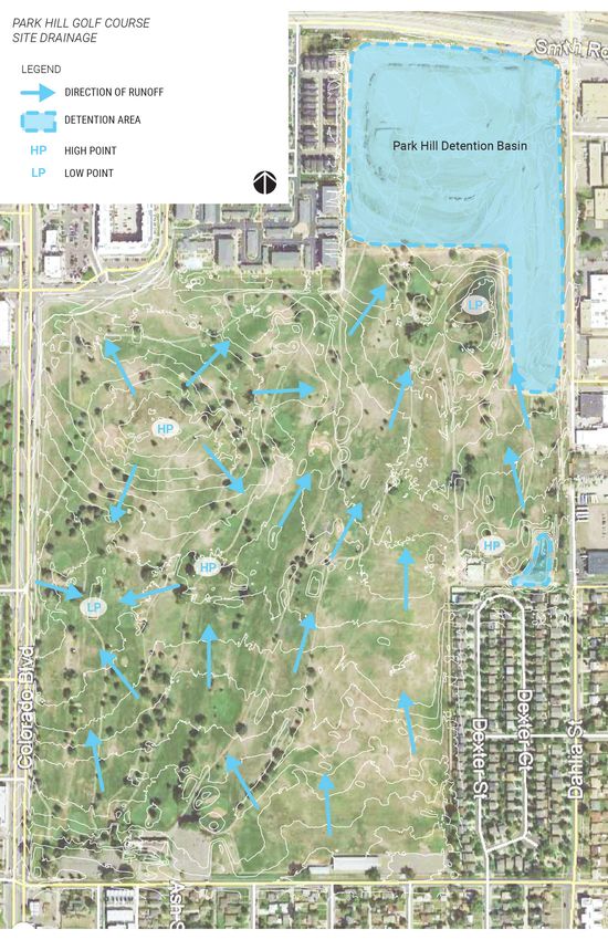
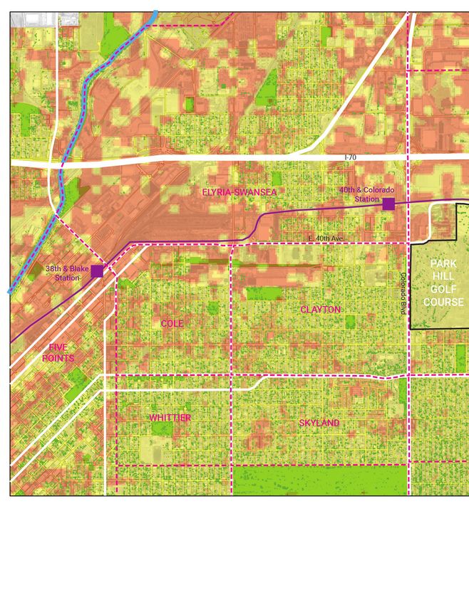
TABLE OF CONTENTS
INTRODUCTION...................................................................................             1
PURPOSE & NEED................................................................................              1
SITE CONTEXT & AREA NEEDS ASSESSMENT..................................                                      1
      SITE CONTEXT MAP..........................................................................            2
GAME PLAN FOR A HEALTHY CITY 2019: SUMMARY.......................                                           4
EXISTING PARKS & OPEN SPACES.....................................................                           6
      EXISTING PARKS & OPEN SPACES MAP.......................................                              10
RECREATION CENTERS.......................................................................                  12
TRAILS..................................................................................................   13
NATURAL AREAS & OPEN SPACES....................................................                            13
      EXISTING TRAILS & POTENTIAL CONNECTIONS.......................                                       14
ECOLOGICAL ASSESSMENT................................................................                      16
TREE INVENTORY.................................................................................            16
      TREE INVENTORY MAP.....................................................................              17
      URBAN HEAT ISLAND & TREE CANOPY MAP...............................                                   18
URBAN HEAT ISLAND..........................................................................                20
DRAINAGE & WATER QUALITY............................................................                       20
      SITE DRAINAGE MAP.........................................................................           21
TRENDS ANALYSIS FOR FUTURE GOLF USE......................................                                  22
OPEN SPACE ENVIRONMENTAL & ECONOMIC BENEFITS...............                                                24
FINDINGS..............................................................................................     26
DEFINITIONS.........................................................................................       27
REFERENCES.........................................................................................        28
NEED
The PHGC Environmental, Parks, Open Space and Recreation assessment is a technical study
that informs the visioning process for the Park Hill Golf Course. This Assessment will establish
the existing conditions and the future needs of the site’s surrounding neighborhoods to inform the
outcomes of this process. Potential options may range from the property returning to its former golf
course use, conversion to a park or open space, development of a portion of the site with residential
and commercial uses with a significant size park space or many combinations of these land uses.

SITE CONTEXT & AREA NEEDS ASSESSMENT
The Park Hill Golf Course property is located in the Northeast Park Hill statistical neighborhood,
adjacent to the Clayton and Elyria-Swansea neighborhoods in Northeast Denver. For the purposes of
this technical assessment, the larger contextual “study area” will extend 1 mile in all directions from
the current property boundary, encompassing portions of Northeast Park Hill, Clayton and Elyria-
Swansea. Situated just to the west of Colorado Boulevard between E. 35th and E. 40th Avenues. The
former golf course (“site”) is at the northern extent of existing residential neighborhoods with large
areas of industrial land and transportation infrastructure to the north and east. Dahlia Street forms
the eastern boundary of the site. The RTD University of Colorado A Line commuter rail and Interstate
70 are both directly north of the site, with the 40th & Colorado Station being less than ½ mile to the
northwest of the property boundary.

There are several existing city parks within 1 mile of the Park Hill Golf Course, the closest being City
of Axum Park to the south, City of Nairobi Park to the west and Boyd Park to the southwest. These
existing parks are all smaller, neighborhood parks ranging in size from 2 to 8 acres, while City Park, a
regional-scale park is just over 1 mile away. An analysis of existing park acreage shows that all three
statistical neighborhoods (Northeast Park Hill, Clayton and Elyria-Swansea) are far below national and
City averages for park acres per capita. This data will be presented in further detail in later sections of
this assessment. There is also one City recreation center, Hiawatha Davis Jr., situated within Skyland
Park just over ½ mile east from the eastern site boundary.

                                                                                                          1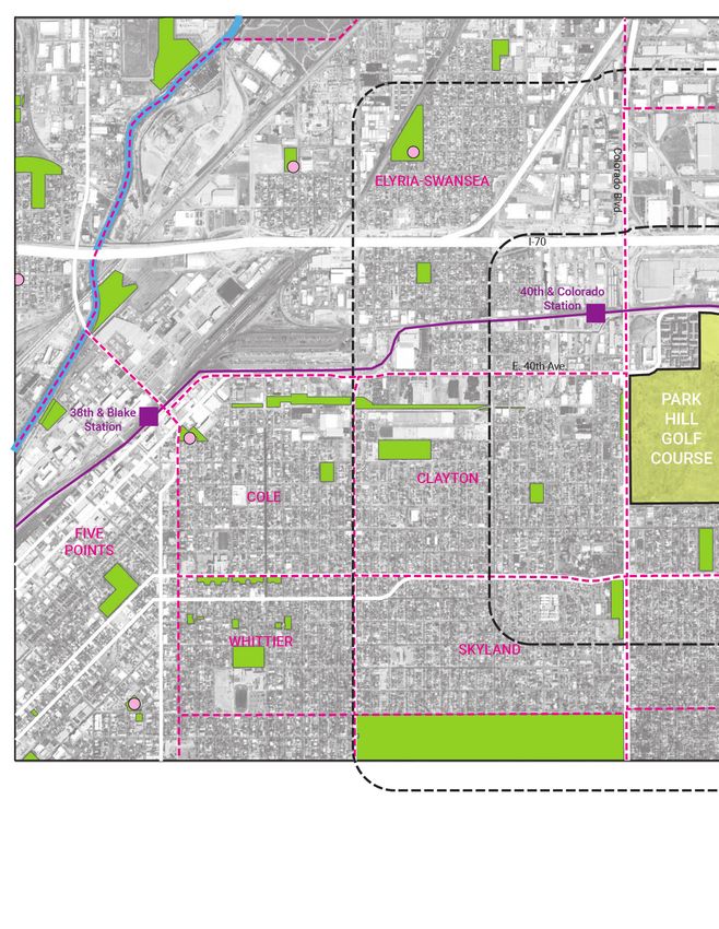
SITE CONTEXT MAP   Park Hill Golf Course “Site”
                   Neighborhood Boundary
                   River or stream
                   Rail transit

  2
Existing Park
Recreation center

                    3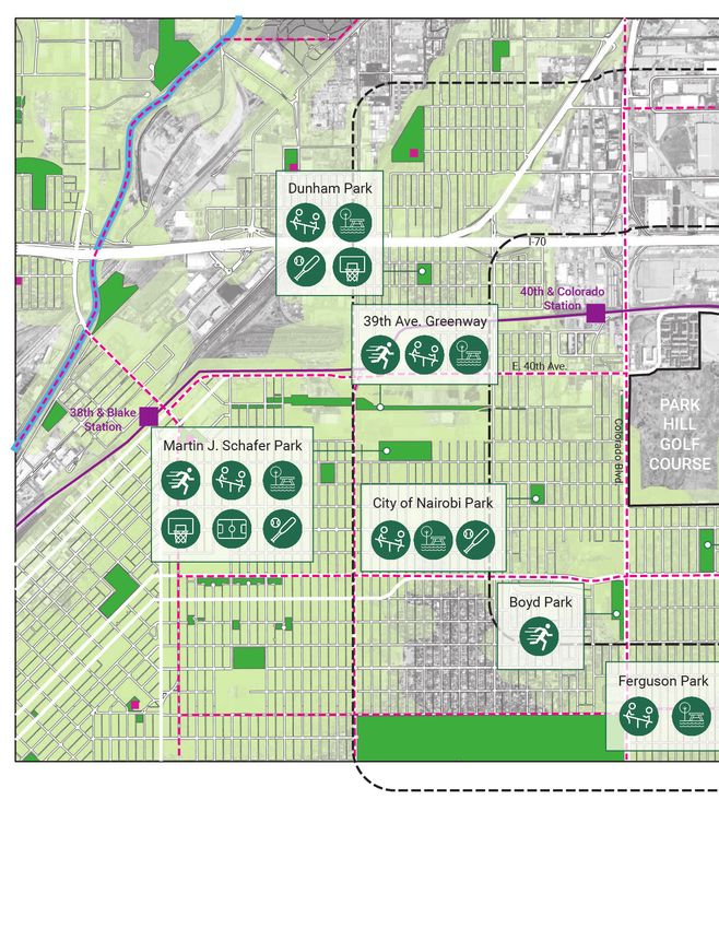
GAME PLAN FOR A HEALTHY CITY 2019
In 2019, Denver Parks and Recreation completed the Game Plan for A Healthy City, part of the City’s
Denveright coordinated planning effort and the Department’s guiding document for the next 20 years.
This Plan is organized around four Guiding Principles:

•   Every Drop: Make the parks system more resilient and environmentally sustainable
•   Every Person: Ensure equity in the distribution of parks and park resources and programming so
    that all residents have the opportunity to improve their personal health and well-being
•   Every Dollar: Manage resources to ensure long term economic and operation health of the parks
    system
•   Uniquely Denver: Provide parks and programming that reflect Denver’s community and cultural
    identity

Each Guiding Principle is further divided into unique Goals and Strategies for realizing the vision.
Furthermore, the Plan identified 25 Priority Strategies based on existing needs, community input and
Departmental priorities. These 25 Priority Strategies are illustrated in the graphic below:

Source: Parks & Recreation Game Plan, May 2019, pg. 20-21

The Park Hill Golf Course site presents a unique opportunity to address gaps in the existing parks and
recreation system, while also addressing many of the 25 Priority Strategies illustrated above. Few
sites within the City & County of Denver allow for the development of large new parks, open space
and recreational facilities, especially in areas that are currently underserved and identified as “High
Need” by the City.

The Game Plan categorizes the neighborhoods near and around the Park Hill Golf Course site as
“High Need” areas for both walkable park access and access to recreation centers. While there are
several recreation centers nearby, and while all of the study area falls within the City’s 10-minute
drive/20-minute bike threshold of a recreation center (Game Plan for a Healthy City, p. 124), much
of the existing infrastructure is challenging to navigate and there are many barriers including
4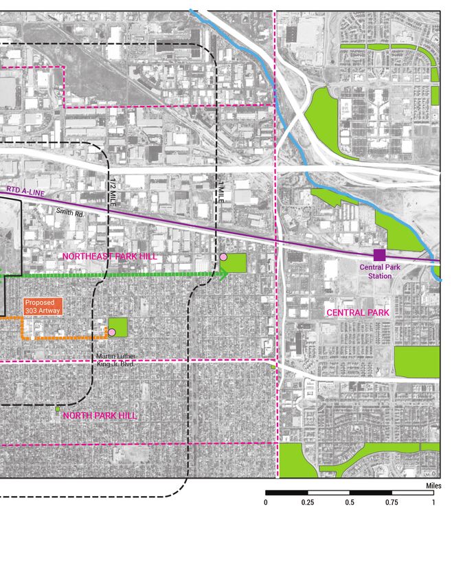
railroads, industrial zones with an inconsistent street grid and no sidewalks and a highway. The
southeast quadrant of the Elyria-Swansea neighborhood, particularly surrounding the 40th &
Colorado Station is identified as a transitioning area with a need for walkable park access (within
a 10-minute walk). Overall, despite eight (8) existing city-owned parks in the study area, all of the
neighborhoods surrounding the Park Hill Golf Course (Northeast Park Hill, Clayton and Elyria-Swansea
Neighborhoods) are defined as “High Need Neighborhoods” for parks and recreation facilities due to:
• Lack of car ownership (less access to a car = higher park need)
• Ethnic and racial diversity (greater diversity = higher park need)
• Population density (denser neighborhoods = higher park need)
• Income (lower income = higher park need)
• Health (greater levels of obesity and chronic disease = higher walkable park need)

                                                          PARK HILL GOLF COURSE

Source: Parks & Recreation Game Plan, May 2019, pg. 124                                             5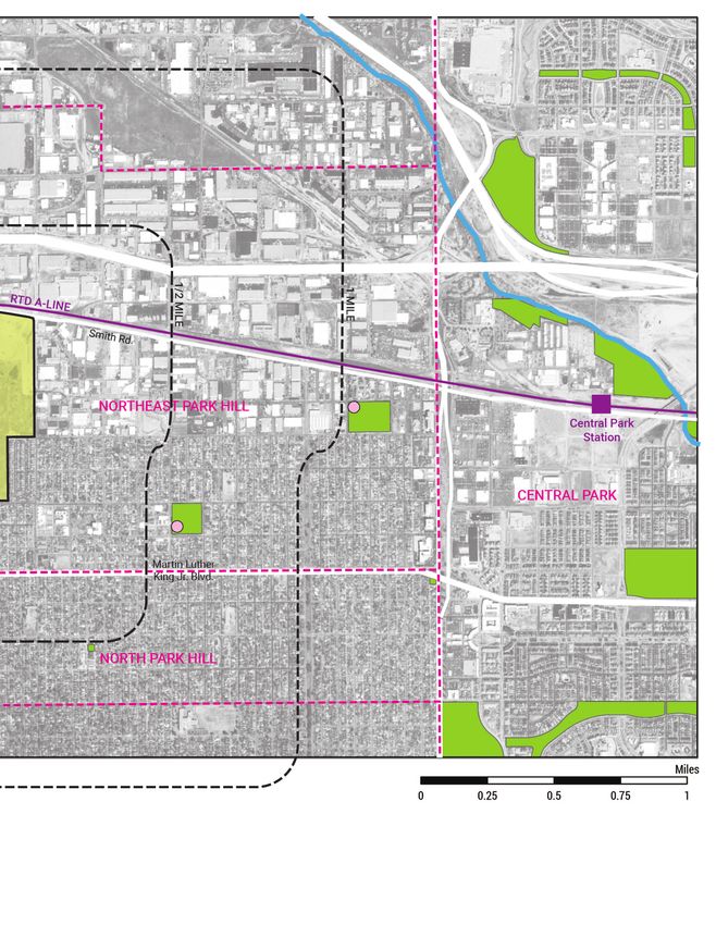
EXISTING PARKS & OPEN SPACES
    As the area around 40th & Colorado Station develops with a higher residential population and
    transitions to a greater mix of uses, and if the Park Hill Golf Course site should hold future residential
    units, there will be a need for new park space to serve current and future residents. The station area
    currently lies outside of a 10-minute walk of any existing parks. The golf course site is close to City of
    Axum Park and within a 10-minute walk.

    The following is a more detailed summary of the existing parks and open spaces within 1 mile of
    the Park Hill Golf Course site, including park acreage and amenities, gaps in the existing 10-minute
    walkshed as defined by the City & County of Denver and an assessment of opportunities to “fill in
    the gaps” at the Park Hill Golf Course site. There are no designated open spaces or natural areas
    within 1 mile of the site. In addition, a comparative analysis of three other Denver neighborhoods was
    completed to illustrate total park acres, park acres per 1,000 residents and park amenities.
Parks & Park Amenities within 1 mile of Park Hill Golf Course
                City of           City of Axum Boyd        Dunham    39th Avenue   Martin J.   Fergunson      Skyland        TOTAL
                Nairobi                                              Greenway      Schafer     (Turtle)
 NEIGHBOR-      Clayton           NE Park Hill   Clayton   Elyria-   Clayton       Clayton     NE Park Hill   NE Park Hill
 HOOD                                                      Swansea
 SIZE           2.3               5.1            4.9       2.5       13.1          8.9         0.3            8.1            45.2
 (ACRES)

 Playground     1                 1                        1         1             1           1              1              7
 Picnic Area    3                 2                        1         1             2           1              1              11
 Baseball/      1                                          1                       1                                         3
 Softball
 Field
 Restrooms                        1                                                                           1              2
 Multi-Use                                                                         1                          1              2
 Field
 Running/                         1              1         1         1                                        1              5
 Walking
 Path
 Basketball                       1                        1                       1                          1              4
 Court
 Tennis Court                                                                      1                          3              4
 Pickleball                                                                                                   4              4
 Court
 Recreation                                                                                                   1              1
 Center
Source: City & County of Denver

    Based on field observations and data collected from the City & County of Denver, the parks within
    1 mile of the Park Hill Golf Course site total 45.28 acres. There exists a mix of park and recreation
    amenities within these existing parks including playgrounds (both traditional and nature play styles),
    picnic areas, running and walking paths, baseball/softball fields, multi-use athletic fields, basketball
    courts, tennis courts, pickleball courts and park restrooms. The table above illustrates the existing
    amenities and their quantities in each of the parks within 1 mile of the site (“study area”). It should
    be noted, however, that the City & County of Denver does not yet have “Level of Service” targets for
    specific recreation amenities. This has been identified by the 2019 Game Plan for a Healthy City as
   6
a next step for establishing baselines to achieve improved equity within the parks system. The table
below shows a comparative analysis of park and recreation amenities within three comparative
neighborhoods in the city, Berkeley, Gateway-Green Valley Ranch and Washington Park. These
neighborhoods were chosen for either their similarity in proximity to a regional park (all three
neighborhoods) or demographic and socio-economic similarities (Gateway-Green Valley Ranch).
This data does illustrate the lack of specific recreational amenities within the study area. Most
notable is the lack of any outdoor swimming pools or other water features such as splash pads
within the study area. The closest public outdoor swimming pool to the Park Hill Golf Course site is
the Swansea Pool located approximately 1.5 miles northwest of the site across Interstate 70. The
Mestizo-Curtis Park Pool is approximately 2 miles to the west of the site with fewer infrastructural
barriers. The Hiawatha Davis Jr. Recreation Center lies within the study area and includes an indoor
swimming pool. Other notable amenities that are lacking in the study area include non-traditional
facilities such as pump tracks, disc golf and adventure skills features.
Park Acres & Amenities by Neighborhood
Berkeley Gateway-Green Washington Clayton Elyria- NE Park
Valley Ranch Park Swansea Hill
Total Park 142.98 302.63 173.21 18.52 43.84 28.92
Acres
Playground 3 7 2 3 5 3
Picnic Area 3 7 5 0 0 3
Baseball/ 4 6 2 2 3 2
Softball Clayton, Elyria-Swansea and NE Park Hill
Field indicated in yellow.
Restrooms 3 2 4 0 0 1 Berkeley, Gateway-Green Valley Ranch and
Washington Park indicated in pink.
Multi-Use 9 9 5 1 2 3
Field
Running/ 3 10* 5* 4 5 4
Walking
Path
Basketball 2 10 4 1 3 3
Court
Tennis Court 10 6 11 1 0 5
Pickleball 0 0 0 0 0 8
Court
Recreation 1 2 1 0 2 2 *Gateway-Green Valley Ranch and
Center Washington Park have many trail and path
loops within their regional parks. This number
Outdoor 1 1 0 0 1 0 is a minimum estimate based on City GIS
Pool analysis.
Source: City & County of Denver
By comparison, the neighborhoods of Berkeley and Gateway-Green Valley Ranch both have outdoor
swimming pools, and all three neighborhoods include greater numbers of basketball and tennis
courts. Gateway-Green Valley Ranch also has many more miles of running/walking paths as the
neighborhood was developed much later and includes many greenways and open spaces in addition
to traditional neighborhood parks.
7PARK ACREAGE by Statistical Neighborhood
Northeast Park Hill Neighborhood
Population 9,643
Park Acres 28.92
Acres per 1,000 Residents 3.00
Clayton
Population 4,862
Park Acres 18.52
Acres per 1,000 Residents 3.81
Elyria-Swansea
Population 6,636
Park Acres 43.84
Acres per 1,000 Residents 6.61
Berkeley
Population 9,360
Park Acres 142.98
Acres per 1,000 Residents 15.28
Gateway - Green Valley Ranch
Population 39,431
Park Acres 302.63
Acres per 1,000 Residents 7.67
Washington Park
Population 7,514
Park Acres 173.21
Acres per 1,000 Residents 23.05
NATIONAL AVERAGE ACRES PER 1,000 13
CITYWIDE AVERAGE ACRES PER 1,000 8.9
Source: ACS 2015-2019; Trust for Public Land; City & County of Denver
Importantly, the neighborhoods of Berkeley, Gateway-Green Valley Ranch and Washington Park all
enjoy much higher quantities of park space both in sheer acres and in acres per 1,000 residents than
the study area neighborhoods. Due to the presence of large, regional parks such as Berkeley Lake
(Berkeley), Parkfield (Gateway-Green Valley Ranch) and Washington (Washington Park), the number
of park acres greatly exceeds that of Clayton, Elyria-Swansea and Northeast Park Hill. Both Berkeley
and Washington Park have park acreage that vastly exceed both the national and citywide averages
as well.
8This page intentionally left blank.
9EXISTING PARKS & OPEN SPACES MAP Park Hill Golf Course “Site”
Neighborhood Boundary
River or stream
Rail transit
10Park
10-minute walk from park
Recreation center
11RECREATION CENTERS
Hiawatha Davis Jr. Recreation Center is located just over ½ mile east from the site boundaries and
serves as a Local Level center, which is Denver Parks and Recreation’s mid-level of service. As defined
by the City, local recreation centers are smaller than regional centers and are open 5-6 days a week.
Most local centers have a variety of fitness classes and activities for drop-in and pre-registered
fitness. Some local centers have a year-round indoor pool and many others have outdoor pools that
are operational during the summer season. Built in 1960, with additional work completed in 1976,
1999, and 2001, Hiawatha Davis Jr. is the only recreation center in the citywide system that offers
an indoor track. Other amenities included in the recreation center are an indoor swimming pool,
multipurpose room, weight room, cycling studio and gymnasium. A game room includes tables tennis,
foosball, air hockey and two billiards tables. In the adjacent Skyland Park, residents have access to 3
tennis and 4 pickleball courts, a basketball court, multi-use fields, a playground and restrooms.
Just beyond 1 mile east from the Park Hill Golf Course is the Martin Luther King Jr. Recreation Center.
This is a Neighborhood Level center offering a multipurpose room, gymnasium, weight room, indoor
lap pool and indoor therapy pool, racquetball/wallyball court and a dry sauna. Both Hiawatha Davis
Jr. and Martin Luther King Jr. Recreation Centers are currently closed due to the COVID-19 pandemic
but are offering a variety of virtual classes and meet-ups for residents. In 2021, Denver Parks and
Recreation will be implementing a phased reopening of recreation centers, pools, registered programs
and other activities. Reopening plans have been developed based on equity; community vs. individual
benefit; maintaining other essential city services and partnerships; and current staffing levels.
The Hiawatha Davis Jr. Recreation Center will begin offering group programming, MY Denver card
activities and free meals on May 3, 2021. Source: Denver Parks and Recreation
Two other small recreation centers, Swansea and Johnson, both lie about 1 mile west from the golf
course site, but are north of Interstate 70 and the railroads and therefore very difficult to access from
Northeast Park Hill, Clayton and the portion of Elyria-Swansea south of the Interstate 70.
PARK HILL GOLF COURSE
Recreation Centers
EXISTING RECREATION CENTERS
Source: Parks & Recreation Game Plan, May 2019, pg. 119
12TRAILS
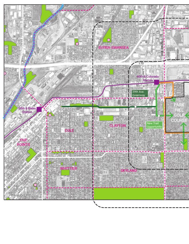
The new 39th Avenue Greenway Trail is the only off-street trail within the study area. While this trail
provides a high-quality bicycle and pedestrian route through Northeast Denver, it lacks off-street
connections to existing parks and the regional trail network. The 39th Avenue Greenway trail’s off-
street portion dead-ends at Jackson Street without reaching the site or the 40th & Colorado Station
directly to the north. On-street connections do exist between 40th & Colorado Station and 38th &
Blake Station. There is an opportunity to further develop this trail and connect to both the transit
station and future parks and open spaces on the Park Hill Golf Course site.
Additionally, the 303 Artway is a proposed 4-mile arts-focused bicycle and pedestrian trail linking
the 40th & Colorado Station to the Holly Square area at Hiawatha Davis Jr. Recreation Center. While
this trail is still to be developed based on future funding by community non-profit groups, there is
opportunity to connect to the existing 39th Avenue Greenway, thereby linking the two trails into
a continuous route between Five Points, the transit station, the Park Hill Golf Course site and the
neighborhood and civic amenities at Holly Square. Combined with future improvements in the River
North district of Five Points, this route could potentially provide a safe, alternative route for residents
of Northeast Park Hill to access Downtown Denver and the regional trail system on the South Platte
River. Future trail connections from the Park Hill Golf Course to the east along East 38th Avenue
would link the site with the Martin Luther King Jr. Recreation Center and potentially through the
Central Park neighborhood to the Sand Creek Regional Greenway.
NATURAL AREAS & OPEN SPACES
There are no existing natural areas or waterways within 1 mile of the Park Hill Golf Course site.
The 39th Avenue Greenway provides an engineered and designed conveyance channel for urban
stormwater management, but is not part of a natural waterway system. The large Park Hill detention
site directly north of the golf course is also part of this larger urban drainage network but at this time
does not include any accessible natural areas, trails or pathways.
39th Avenue Greenway, looking west. Source: KDVR Denver
13EXISTING TRAILS & POTENTIAL CONNECTIONS Park Hill Golf Course “Site”
Neighborhood Boundary
River or stream
Rail transit
14Park
Recreation center
Existing off-street trail
Potential trail connection
Proposed 303ArtWay Trail
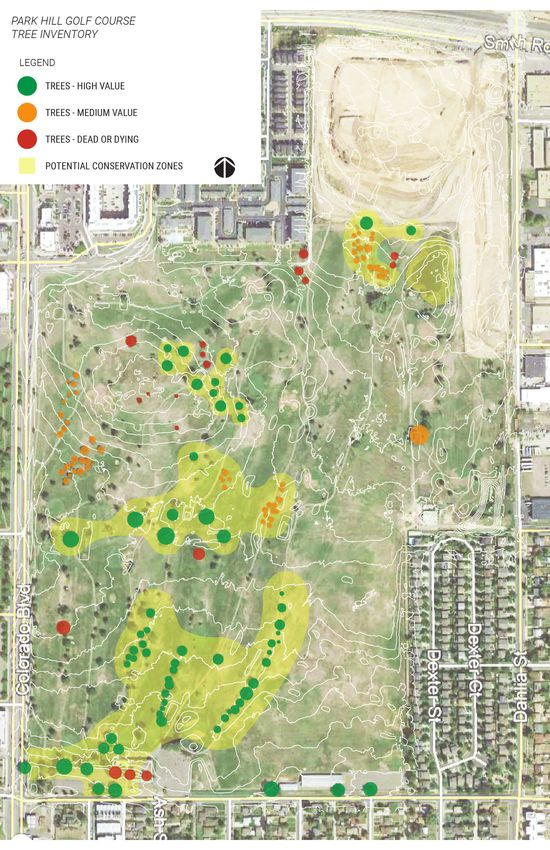
15ECOLOGICAL ASSESSMENT The Park Hill Golf Course site is a former manicured golf course occupying 155 acres in Northeast Park Hill. Situated along the east edge of Colorado Boulevard (a major urban arterial) between E. 35th Avenue and E. 40th Avenue, and surrounded by fully developed residential and industrial areas, the site lacks connection to any natural areas or open spaces. Typical of most golf courses in the high plains of Colorado, the site includes some trees that defined the golf course fairways, a mix of non-native turf grasses and no natural habitat features or waterways, except for a small irrigation pond formerly used for golf course irrigation storage. Though it is safe to assume that many animals adapted to urban areas have made their homes on the site, including squirrels and other rodents, birds and insects, the site is not part of any large-scale regional habitat areas. However, the larger Denver region is part of a principal route along the Central Migration Flyway for various bird species including the American robin, American kestrel and Kildeer (Source: US Fish & Wildlife Service) and many migrating birds may utilize the existing trees and open space of this site because of the lack of urban development. TREE INVENTORY This section provides a high-level summary of the existing tree resources on the site and an assessment of areas best suited for conservation efforts. It should be noted that this is not a detailed arborist study of the site, but based on visual survey and best practices recommendations by the landscape architect and planning consultant team. At this time, it is unclear to the consultant team and the City the age and health of existing trees and whether best practices for tree planting and maintenance were employed on site. Additional analysis should be performed by licensed arborists to verify the health of existing trees and opportunities for preservation in place, transplant or removal. The Park Hill Golf Course site includes a mix of approximately 440 trees in varying degrees of health and size scattered across the 155 acres, though primarily concentrated on the western 2/3 of the property. These trees are often found in small groves or linear groupings oriented north-south between the former golf course fairways. A mix of species is present including ash, elm, honey locust, various oaks and conifers, with some smaller ornamental trees concentrated on the southern end of the site. The most likely trees for preservation in place, based on a visual inventory of size and health with the City Forester, are located along a central east-west axis from Colorado Blvd. to about the center of the site, and several areas concentrated in the south-central portion of the property. There are several large, mature elms, ashes and honey locusts worth preserving as part of future parks and open space for both shade and habitat opportunities. Several small groves of medium-sized oaks are also in good health and would provide a pleasant feature for future parks. A small grove at the northeast edge of the site, adjacent to the new Park Hill detention basin, is also worth preserving as part of a future parks and open space corridor. The diagram on the opposite page highlights the trees best suited for preservation in place or possible transplanting efforts if size allows, and identifies larger opportunity areas around the trees that are well-suited for conservation efforts in order to maximize tree health, shade, habitat and water. Also indicated are trees that are already dead and other groves of trees that could be of low- to medium-value for preservation. 16
17
URBAN HEAT ISLAND & TREE CANOPY   Park Hill Golf Course “Site”
                                  Neighborhood Boundary
                                  River or stream
                                  Rail transit

  18
Park
Urban heat island: Hot
Urban heat island: Warm
Urban heat island: Cool
Tree canopy
19URBAN HEAT ISLAND The urban heat island effect is a major concern facing urban areas in the 21st century. Created through a combination of paved, or impervious, and non-reflective surfaces and buildings, city neighborhoods absorb the heat from the sun and often experience air temperatures several degrees higher than surfaces with natural vegetation and soil. Urban trees and the urban forest collectively can help cities make major strides in combating this warming effect. Urban trees act as a filter for solar radiation between the sun and the ground, streets, sidewalks and homes, while providing shade to help cool the immediate air. As shown in the previous map, the Park Hill Golf Course site itself has a fairly low urban heat island effect due to the lack of paved surfaces and predominance of turf grass. Yet, the site also has a very low amount of area shaded by tree canopy. The existing canopy coverage from the roughly 440 on-site trees totals approximately 11 acres, or 7% of the total site area. The Northeast Park Hill neighborhood as a whole has approximately 18% tree canopy coverage. When combined with Clayton and Elyria-Swansea, the three neighborhoods have 4,513 total trees with an overall tree canopy coverage of approximately 16.33%. The average tree canopy coverage citywide is 24.46%. Source: Denver Parks & Recreation Tree Report Card DRAINAGE & WATER QUALITY The Park Hill Golf Course is part of a larger city-wide drainage basin known as Platte to Park Hill that has seen recent improvements and additional infrastructure to address historic flooding issues in Northeast Denver neighborhoods. The new, large Park Hill detention basin sits directly north of the former golf course site and links to other underground stormwater systems in the area. This detention basin provides a unique opportunity to become a feature of future parks and open space on the site, though currently lacks any amenities or pathways. The 39th Avenue Greenway, another part of the larger Platte-to-Park Hill drainage network, begins several blocks to the west of Colorado Blvd. and runs east toward Five Points and new outfalls at Globeville Landing Park. This greenway includes new multiuse trails but currently does not connect to any park or open space amenities or nearby transit stations through designated off-street facilities. The site gently slopes from south to north and the detention basin captures much of the water from this site. A small high point in the northwest corner of the property drains some runoff toward Colorado Blvd. and E. 40th Ave. which is likely captured by on-street inlets. An additional small pond in the northeast corner of the property is not connected to the detention basin, as it was previously used for irrigation water for the golf course. A small detention area on the east edge of the property along Dahlia St. provides some stormwater capture for the adjacent streets and neighborhood. 20
21
TRENDS ANALYSIS FOR FUTURE GOLF USE
Key Trends
• Nationally, the supply of golf courses has contracted by about 10% since 2006 and golf
   participation has also decreased since the early 2000’s.
• Nationally, 34.2 million people participated in on‐course and off‐course golf in 2019 and golfers
   are becoming younger and more diverse. Covid‐19 has increased demand.
• Shorter, less‐time consuming courses are becoming more popular to align with modern, busy
   lives.
• Technology is increasingly being used to improve game performance and increase viewership.
• Courses are seeking ways to reduce their environmental impact to better align with user concerns
   and increase their sustainability, including financial sustainability.

Golf Course Supply and Participation
This section describes trends in golf courses as well as the potential for continued golf activity at
the Park Hill Golf Club. According to the National Golf Federation there were 14,300 golf facilities
in the United States at the end of 2019. Three quarters of them were open to the public. There are
10% fewer courses now than in 2006 when a 20‐year golf course expansion cycle in the United
States came to an end, one that resulted in an oversupply of courses. Course closures have been
concentrated among public facilities and 9‐hole, “value‐priced courses” with a greens fee of under
$40. (National Golf Foundation, 2021)

Golf participation is tracked by on‐course and off‐course activities. Off‐course activities include
use of driving ranges, indoor golf simulators or golf entertainment venues. Nationally, on‐course
participation was lower in 2019 (24.3 million) than in 2014 (24.7 million), with even lower participation
from 2015 to 2018. And these rates of participation are all lower than in the early 2000’s. Off‐course
participation on the other hand has consistently increased since 2014 to 9.9 million in 2019, a roughly
83% increase over that time. About 40% of off‐course participation is by young adults. Women make
up another 40% of off‐course golfers, with particular interest in driving ranges.

In Colorado, there are about 240 golf courses. Golf participation in the state has been fairly flat since
the 1990’s. According to the Colorado Golf Association, the number of rounds played per year from
2015 to 2019 was around 1.7 million. The lowest participation was in 2019. Following Covid‐19
related course shutdowns in the spring of 2020, golf participation spiked as people sought outdoor
recreational activities where appropriate distance could be maintained. Despite an increase in
demand, golf revenue in 2020 is likely to take a hit and there is uncertainty whether the increased
pandemic demand will continue as Covid‐19 concerns subside. (Colorado Golf Association, 2021)

Golfer Demographics
The sport’s demographic makeup remains majority male, with just under one quarter (23%) of
participants in 2019 being female. Of the 24.3 million people who golfed on a course in 2019, 6.1
million were young adults (18‐34), a demographic that the National Golf Foundation says is the sport’s
biggest customer age segment; 2.5 million were juniors, with just over a third being female and about
a quarter minority, a figure that is up from 6% 20 years ago. Combined, juniors and young adults make
up about 35% of all on‐course golfers. Senior (65+) participation increased to 5.3 million in 2019 and
is expected to increase as boomers continue to reach retirement age.

The number of rounds played is dramatically different by age group. Seniors, unsurprisingly, play
more rounds on average (36) than young adults (12). And despite the majority of course closures
being 9‐hole courses, and mostly public, the broader trend is an increased demand for shorter 9‐hole
courses that are less time consuming.
22
Offshoots like Disc Golf / Frisbee Golf and developments like Top golf are golf‐related activities which
are accessible and can serve as an introduction to the more traditional golf game. Disc / Frisbee golf
can be played on golf courses. Discs are used instead of golf balls and baskets are installed on the
course. Topgolf is a large driving range featuring electronically monitored targets and microchipped
balls. It’s designed to allow for mass participation in an entertainment‐type venue.

In addition, to the demand for shorter courses and golf‐related activities, the changing demographic
profile of golfers is driving new trends. Women are increasingly interested in the sport and one in four
golfers today is female. This trend is also resulting in more beginner and junior golfers as women
are introducing their children to the sport. One in three golfers is a millennial and their increasing
participation, along with Gen Z, is driving an increased use of technology, demand for new food and
beverage options, apparel innovation, etc.

Technological Advances and Changing Tastes
The changing demographics and food and beverage consumption trends more broadly are increas-
ing demand for healthy food options on courses, along with provision of craft beer and more cocktail
options. As social media usage continues to increase, golf coverage and promotion is increasingly fo-
cused on reaching golfers through social channels and not just historic media outlets like television.

The sport’s changing demographics and participant desires has also resulted in a trend among devel-
opers to create communities focused more on family‐focused entertainment, not just building homes
around a course with a clubhouse. Instead, there is more of a focus on providing a range of communi-
ty amenities, including classes and events, with golf being just one of many options.

In addition, some courses are changing the way they use their vast acreage with more attention being
paid to their environmental impact. This includes consideration for more effective water management
and conservation, biodiversity and reducing their carbon footprint. For example, some are turning
areas not really used into non‐irrigated, unfertilized land for flowers, food, or grazing animals. Some
are downsizing their land footprint, which aligns with demand for shorter play times. Others maximize
use by providing year‐round activities, such as cross‐country skiing. More courses are working to be
carbon positive, a trend expected to continue.
Sources: (National Golf Foundation, 2021; Colorado Golf Association, 2021; Donnally in Urban Land, 2015; Denver Business Journal, 2020).

                                                                                                                                           23
OPEN SPACE ENVIRONMENTAL & ECONOMIC BENEFITS Urban green space provides substantial environmental benefits ranging from preservation of biodi- versity to curbing carbon emissions. Cities are still grappling with air and water pollution, heat island effects, and stormwater management; natural solutions have proven to help mitigate these urban problems. Trees and shrubs can filter toxic chemicals from the air, covered soil can act as a natural filter for water pollution and stormwater drainage, and trees, again, are natural air conditioners help- ing cities remain cooler during sweltering summer months. Cities are also major contributors to the climate crisis. Well-vegetated parks can help reduce the number of pollutants in the atmosphere and curb carbon emissions. Urban parks provide clear benefits to individuals, communities, and cities. The key findings are as follows: Environmental Benefits Key Findings • Urban parks are effective at filtering air, water, and noise pollution. • Vegetation reduces pressure on hard infrastructure by absorbing rainwater, curbing surface runoff, and cut costs to municipalities. • Urban parks help mitigate heat island effect in cities. • Urban parks are effective at drawing down carbon emissions through carbon capture and storage. Urban parks provide substantial environmental benefits ranging from preservation of biodiversity to curbing carbon emissions. These areas can be categorized into five areas: Pollution Control, Water Management, Micro-Climate Regulation, Biodiversity and Nature Conservation, and Climate Change Mitigation. Pollution Control Urban parks can play a pivotal role in reducing air pollution. Studies have found that one acre of tree cover in a park may reduce roughly 80 pounds of air pollution per year but could be as high as 200 pounds in a more polluted city with a longer growing season. The estimated value of pollution remov- al per acre of tree cover is about $300 per year. (Nowak, 2010) TPL found that Denver’s park system, saved the city $128,914 ($2009) in air pollution costs annually (TPL, 2010). Urban forests, bioswales, rain gardens, and other types of green infrastructure in parks can help re- duce runoff and filter pollutants such as heavy metals, animal waste, oils, and chemicals. (Sadeghian, 2013) Water Management Impermeable surfaces such as roads, sidewalks, parking lots, and rooftops prevent water from ab- sorbing into the ground. This causes significant challenges, such as flooding and degraded water quality. Trees and ground cover are a more cost-effective and efficient tool for managing stormwater runoff than traditional hard infrastructure. Vegetation allows water to seep into the ground, slowing the rate at which it reaches stormwater infrastructure. This helps reduce localized flooding and in- creases water infiltration to promote groundwater recharge and evapotranspiration. TPL estimated that Denver’s park system saved $804,187 in stormwater management costs in 2009 (TPL, 2010). Micro-Climate Regulation Cities are prone to a phenomenon dubbed the urban heat island effect, where urbanized areas are up to 5°C hotter compared to surrounding rural areas (Sadeghian, 2013). This is due to dense urban infrastructure such as buildings and roads that absorb and re-emit the sun’s heat. Vegetation, such as 24
trees, function as a natural air conditioner and help keep cities cool in the summer and reduce wind
speed in the winter; mitigating the effects of glass and concrete. A study in Chicago found that a 10%
increase in tree coverage could reduce the total energy for heating and cooling by $50-100 per dwell-
ing per year.

Biodiversity and Nature Conservation
While urban parks enhance peoples’ connection to the natural world, they also help maintain viable
populations of species that would otherwise disappear from the landscape. Vegetation corridors help
link urban green space, supporting and enhancing urban biodiversity and protecting vulnerable spe-
cies (Savard, 2000; Talal, 2020).

Parks and Climate Change
Parks with trees and vegetation can help drawdown carbon emissions in cities by directly removing
and storing carbon and indirectly reducing air temperature and building energy use. It is estimated
that U.S. park trees can store around 75 million tons of carbon ($1.6 billion) and remove about 2.4
million tons of carbon ($50 million) annually. One acre of park tree coverage can store roughly 40
tons of carbon and remove 1.2 tons of carbon per year. This amounts to $800 per acre of carbon
storage per year and $25 per year for carbon removal (Nowak, 2010). As discussed earlier, trees and
parks can help mitigate heat island effects and reduce energy use and, consequently, carbon emis-
sions from power plants.

                                                                                                      25
FINDINGS The Park Hill Golf Course site presents an opportunity to address gaps in the existing parks, open space and recreation network for residents of Northeast Denver, create new non-automobile connections to nearby recreation, civic and transit amenities, and provide contemporary models of urban stormwater management, resiliency and ecology needs. A sizeable amount of new parks and open space would provide residents of adjacent neighborhoods with new recreation amenities and fill the gap in walkable park needs for new development and population growth that may be anticipated near the transit station. Within the three statistical neighborhoods of Northeast Park Hill, Clayton and Elyria-Swansea there are 91.28 acres of City park land for a combined resident population of 21,141 (Source: ACS 2015-2019), which equates to 4.32 acres per 1,000 residents. In order to meet the national average of 13 acres per 1,000, the City would need to increase total park acres to 274.8 within the three neighborhoods, an increase of 183.5 acres. The Park Hill Golf Course site can help advance toward those goals but it will also be important to increase park access throughout these neighborhoods to ensure all residents are within a 10-minute walk of a park. Any future parks and open spaces that may occupy the site, should also address gaps in the park and recreation amenities within the surrounding neighborhoods. The City should develop level-of- service targets for facilities, services and specialized park amenities (Source: Parks & Recreation Game Plan, Strategy 3.4), combined with statistically valid surveys of resident needs and desires, use any future vision of the site to accommodate these needs and address the gaps. Additionally, future parks and open spaces on the site should be designed so as to preserve or transplant as many mature, healthy trees as possible, creating ready-made shade assets to address the urban heat island effect. Preserving mature tree canopies within new parks and open spaces will also protect habitat for urban wildlife and migrating birds. Utilizing existing topography and the adjacent Park Hill Detention basin, stormwater runoff can be directed toward the new parks and open spaces which, when intentionally- designed, can serve dual functions for both recreation and environmental quality. However, any future development or redevelopment would still be required to provide stormwater management as parks are not typically used to satisfy stormwater requirements. New off-street trail network connections can provide residents with new healthy mobility options and lower the rates of vehicle use to nearby and citywide recreational assets such as regional parks, the South Platte River and Sand Creek regional trails, community and civic amenities and transit stations. 26
DEFINITIONS
Designated Natural Area: City-owned land that has been designated by the DPR executive director based
on ecological function and condition, outdoor education potential, and connection to the community; the
Office of the City Naturalist coordinates management. (Game Plan for a Healthy City)

DPR: Denver Parks and Recreation (Game Plan for a Healthy City)

Equity: a condition when everyone has the opportunity to thrive, reducing or eliminating persistent
institutional biases and barriers based on race, ability, gender identity and sexual preference, age, the
environment and other factors. Equity acknowledges that treating every person or place exactly the same
may not result in fair opportunities to succeed. (Game Plan for a Healthy City/Comprehensive Plan 2040/
Blueprint Denver)

High-need neighborhood: neighborhoods with a greater demand for park space based on demographic,
health, and urban context. High need neighborhoods have higher percentages of lower income
households, less access to personal vehicles, and higher obesity rates and other health disparities so
having walkable park access is particularly important. (Game Plan for a Healthy City)

Level-of-service: Level-of-service targets are goals describing how many amenities of various types are
required to meet the demand of a certain number of residents. For example, level-of-service targets could
include 1 baseball or softball field for every 5,000 residents, or 1 indoor pool for every 15,000 residents.
Level-of-service targets can help gauge how well the City is providing parks and recreation amenities to
meet resident demand. (Game Plan for a Healthy City)

Open space: The term open space defines parcels of land to preserve land, water, vegetative, historic,
cultural or aesthetic features in their natural or primarily natural state. The goal of open space is to
achieve the following:
• To provide opportunities for people to experience and connect to nature.
• To protect acreage containing natural resource values of community-wide significance including
    wetlands, wildlife habitats, urban forests, and scenic areas.
• To protect and restore healthy wildlife habitats and functional ecosystems maximizing their ability to
    provide ecosystem services to Denver Residents
• To help mitigate the effects of climate change on Denver residents.
• To protect water quality and manage water use.
Open space development and amenities would be limited to essential improvements like walk and trail
pathways, seating, shade and overlooks. Open space park classifications include: Greenways, Linear
Parks, Naturalized Areas of Urban Parks, Natural Areas, Mountain Parks, and Native Landscapes as
defined by the Landscape Typology manual. (Denver Parks & Recreation)

Park: Lands and landscape that are acquired, developed, and managed for enjoyment by people,
promotion of physical fitness, enhancement and preservation of the environment, and conservation of
natural resources. (Game Plan for a Healthy City)

Urban heat island: The effect of pavement and buildings to absorb heat and increase the air temperature
of surrounding areas. “Urban heat island” refers to an area with a concentration of pavement and
buildings that feels hotter than surroundings. In contrast, parks and green space have a cooling effect on
air temperature. (Game Plan for a Healthy City)

                                                                                                           27
REFERENCES City & County of Denver, (2019) Blueprint Denver: A Blueprint for an Inclusive City. City & County of Denver, (2019) Parks & Recreation Game Plan for a Healthy City. City & County of Denver, Office of the City Forester, Tree Report Card. Colorado Golf Association. https://www.coloradogolf.org/rounds‐revenue‐article/. January, February 2021. Donnally, Trish (2015, March 4). Golf: No Longer a Hole in One. Urban Land. Denver Business Journal (2020). https://www.bizjournals.com/denver/news/2020/05/15/colorado‐ golf‐courses‐2020‐coronavirus.html National Golf Foundation. https://www.ngf.org/golf‐industry‐research. January, February 2021. Nowak, D. J. and Heisler, G. M., (2010). Air Quality Effects of Urban Trees and Parks. National Recre- ation and Park Association. Sadeghian, M. M. and Vardanyam,Z. (2013). The Benefits of Urban Parks, a Review of Urban Re- search. Journal of Novel Applied Sciences 2(8), 231-237. Savard, J. P., Clergeau, P., and Mennechez, G. (2000). Biodiversity concepts and urban ecosystems. Landscape and Urban Planning 48, 131-142. Talal, M. L. and Santelmann, M. V. (2020). Vegetation management for urban park visitors: a mixed methods approach in Portland, Oregon. Ecological Applications 30(4), https://doi.org/10.1002/ eap.2079. The Trust for Public Land Center for City Park Excellence. (2010). The Economic Benefits of Denver’s Park and Recreation System. http://cloud.tpl.org/pubs/ccpe-denver-park-value-report.pdf. U.S. Census Bureau, (2019) American Community Survey. https://www.census.gov/programs-sur- veys/acs
You can also read