SEDIBENG WEST 2020 - Grade 12 - Term 1 and Term 2 A Study Program for improving Geographical Knowledge - Wingen Heights Secondary
←
→
Page content transcription
If your browser does not render page correctly, please read the page content below
SEDIBENG WEST
                  2020

            Grade 12 – Term 1 and Term 2

A Study Program for improving Geographical Knowledge …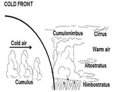
SW GEOG 12 2020 KN
Note to candidate:
STEPS BEFORE BEGINNING YOUR GEOGRAPHY STUDY PROGRAM:
1. Organise your knowledge for revision: - sort through your notes and only focus on which topic you have selected.
Always determine which topics/sub topics/ areas of content you are less sure of. Develop a Timetable that indicates
the topics you are studying and not just Geography
2. Include other unavoidable academic / work /family commitments, and time for relaxation, or exercise on the timetable.
(Time Management)
3. Set a revision timetable with realistic goals.
4. Plan your revision as far in advance as possible.
5. Use past papers to get used to the way questions are worded -Get used to the kind of language used in exam
questions. Compare the question techniques and mark allocation.
(you must be able to determine an easy question from a difficult question)
6. Plan and practice paragraph writing using preferred methods.
(when you study write at least five (5) to six (6) points and then verify if these are correct)
7. Make notes, improve them and structure them meaningfully
(The notes you create for June and Preparatory Examinations will serve as a basis for study materials for the final
examination)
8. Review your notes and think about what was covered in class.
(Always refer back to your notes/source material/textbooks/examination papers and study guides to make sure you
have the correct/precise idea about each topic)
9. You MUST rewrite notes as you study in order to improve your writing and remembering skills.
10. You MUST underline and highlight important ideas and vocabulary/concepts/terminology in your notes.
HOW TO USE THE GEOGRAPHY STUDY MATERIAL?
You must commit to memory as many points as you can remember on the sub topic
The essential foundations of each question cut across the various topics required in the CAPS so you must be able to
apply your answers to the correct questions.
Always use "geography" key words and "geography" key concepts to remember as many of the points given in this
guide.
ONCE YOU HAVE COMPLETED REMEMBERING ALL THE POINTS, CONTINUE TO REVISE BY LOOKING AT
VARIOUS DIAGRAMS FROM TEXTBOOKS AND PREVIOUS EXAMINATION PAPERS.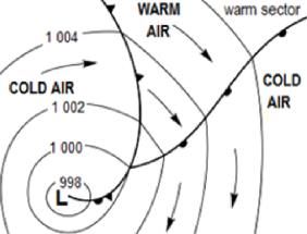
SW GEOG 12                                           2020                                                           KN

              NOTE TO CANDIDATE:                     ICONS USED IN THIS GUIDE

                                 Commit to memory. These are points in a topic that must be remembered for the
                                 examination. A simple strategy is the use of neumonics to remember Geographical
                                 concepts and terminology e.g.

                                 To remember characteristics of associated weather of a Tropical Cyclone during
                                 the mature stage:

                                 S–       Storm surges along coastal regions
                                 G–       Gale force winds
                                 T-       Torrential rainfall
                                 E–        Isobars are evenly spaced and steep in the centre of           the
                                          pressure system
Hints and Tips on WHAT and HOW
                                 A–       Average temperatures above 26,5 °C in the Mature Stage
to study to remember.

                                                                     SGTEA
                                 Now … Taking all the first letters from the key words above I can form the word

                                                                     GATES
                                                                      .
                                 Now … Repeat the word and try to remember what each letter represents

                                 The terminology lists must be remembered as part of the topic/sub topic.
                                 Remember the headings of each topic are important to remember. If you are able
                                 to remember the topics and KEYWORDS for each topic, you will be able to
                                 organise the information that you are studying into coherent, logical and structured
                                 answers during the examination
Useful hints and tips when
studying: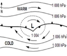
SW GEOG 12                                                  2020                                                           KN

Let's get started …

                                           MID-LATITUDE CYCLONES

                                                 What do you need to know?

                                      (Temperate, Extra-Tropical Cyclones, Depressions)

STAGES OF FORMATION
                                                      STAGE 1                    STAGE 2                        STAGE 3

COLD FRONT CONDITIONS:

CHANGES IN WEATHER CONDITIONS WHEN A COLD FRONT PASSES OVER A LOCATION:
        •     Temperature decreases
        •     Air pressure decreases as the cold front approaches and then increases as the cold sector            arrives.
        •     Humidity decreases as the cold sector arrives.
        •     Warm, moist unstable air is intensely uplifted at the steep cold front. The air cools to dew point temperature and
              condensation occurs to form a dense Cumulonimbus Cloud.
        •     Thunderstorms and Rain occur.
        •     Wind Shifts occur. Wind changes DIRECTION.
        •     In the SW Cape (Southern Hemisphere) the wind changes in an anti-clockwise direction known as backing. (From
              NW to W then SW and finally S).
        •     In the Northern hemisphere the wind Veers         (Changes direction in a clockwise direction).
SW GEOG 12 2020 KN
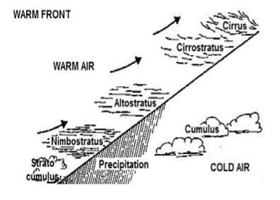
WARM FRONT CONDITIONS:
CHANGES IN WEATHER CONDITIONS WHEN A WARM FRONT PASSES OVER A LOCATION:
• Temperature increases
• Air Pressure decreases as the cold front approaches and then increases as the cold sector arrives.
• Humidity increases as the warm sector arrives.
• Warm, moist unstable air is uplifted at the gentle warm front.
• The gentler warm front causes the area affected by the clouds and rain to be greater.
• Cirrus clouds appear first at high level, then Altostratus and then Nimbostratus Clouds which causes Soft,
Soaking Rain.
CONDITIONS FOR THE DEVELOPMENT OF A MID-LATITUDE CYCLONE:
• Two different air masses (warm and cold air masses) meet
• Cold polar easterlies meet westerlies along the polar front
Develop into mid-latitude cyclones because:
• Between 30°- 60° N/S of the equator (frontal zone )
• Warm air mass is uplifted (then displaced )
• Uplift results in condensation
• Increased cloud cover
• Will result in precipitation
THE ENVIRONMENTAL IMPACT A MID-LATITUDE CYCLONE MIGHT HAVE. (Negative effects)
• Flooding
• Soil erosion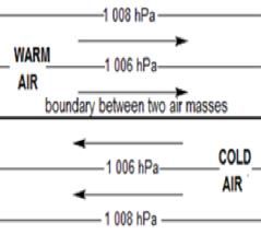
SW GEOG 12                                                  2020               KN

       •     Destruction of natural ecosystems
       •     Loss of natural habitat for animals
       •     Veld fires destroy vegetation
       •     Destruction       of coastlines
       •     Damage to coastal dunes
       •     Loss of agricultural land
       •     Snow / low temperatures result in loss of livestock
       •     Destruction of infrastructure
       •     Destruction of homes

                                               TROPICAL CYCLONES

                                                   What do you need to know?

STAGES OF FORMATION

FAVOURABLE CONDITIONS FOR THE DEVELOPMENT OF A TROPICAL CYCLONE
(FACTORS + EXPLANATION)

       •     Warm ocean - above 26.5 °C
       •     Warm ocean - Needed to provide heat energy and moisture
       •     Rapid/High evaporation rate for condensation to occur
       •     Condensation - latent heat          to be released
       •     Located between 5° - 30° north / south of the equator
       •     Coriolis force is ineffectual at the equator (0° - 5°)
       •     Air is mostly unstable
SW GEOG 12 2020 KN
WEATHER CONDITIONS ASSOCIATED WITH THE MATURE STAGE OF TROPICAL
CYCLONES:
• Heavy rains (torrential rainfall ) resulting in flooding
• Pollution of water
• Human injuries and possible deaths
• High wind velocity (gale force winds ) damages structures vegetation, crops and livestock
• (storm surges ) waves - Coastal erosion
• Saline (salt water) intrusion of low lying coastal areas
HOW TRACK THE PATH OF TROPICAL CYCLONES:
• Satellite imagery
• Air radar and remote sensing sounds
• Radar
• Weather reports
PRECAUTIONARY METHODS
• Listening to forecasts
• Construction of seawalls/ dredged coastal areas
• vacate low ground
• board up windows
• sandbags to reduce coastal flooding
• good communication
• evacuation centres
• clear evacuation routes
• housing on stilts
• strong materials
• storm warden patrols
HOW DO WE KNOW WHEN A TROPICAL CYCLONE HAS REACHED ITS MATURE STAGE?
• NB: Air Pressure must have dropped and rapidly decreasing to well below 1000 hPa,
• NB: Cumulonimbus clouds would have formed.
• NB: Covers a large area and the symbol denoting the eye is evident
SUBTROPICAL ANTICYCLONES AND ASSOCIATED WEATHER CONDITIONS
Draw a diagram that illustrates the air movements of Southern African Anticyclones when they RIDGE over the
coastline of South AfricaSW GEOG 12 2020 KN
Describe the air movement in these pressure systems with the use of a diagram
Draw and Label on your diagram the weather conditions associated with these pressure systems during summer and
winter
Draw the positional changes of anticyclones and how they affect the weather conditions during summer and winter
Comment on the "variation" in temperature in the interior and along the coastal areas according to these anticyclones
STATE THE DIFFERENCE IN THE WEATHER CONDITIONS EXPERIENCED DURING WINTER
AND SUMMER OVER THE SOUTH AFRICAN INTERIOR BY REFERRING TO THE ROLE
PLAYED BY THE Kalahari High Pressure.
Summer Winter
Moist air Dry air
Cloudy No clouds
Rainfall Little/no rain
No frost Frost at night
Small temperature ranges Large temperature range
EXPLAIN WHY SUNNY CONDITIONS MAY BE INDICATED FOR ALL THE INLAND (Interior)
WEATHER STATIONS.
(Winter conditions)
• Inversion lower than the escarpment
• Warm moist air cannot reach the interior
• Little moisture over interior will reduce condensation
• No cloud formation to block out the sun
WHY IS THERE A VERTICAL POSITIONAL CHANGE OF THE INVERSION IN WINTER?
(Inversion lower than the escarpment) TO SUMMER (Inversion higher than the escarpment) OF
GREAT IMPORTANCE TO FARMERS ON THE SOUTH AFRICAN PLATEAU?
• During summer moist air reaches the interior
• Precipitation over the interior
• Rivers filled with water
• Farming can take placeSW GEOG 12 2020 KN
NOW MAKE A DETAILED STUDY OF SOUTH AFRICAN BERG WINDS TO COMPARE HOW
POSITIONAL CHANGES IMPACT AIR MOVEMENTS.
Draw a diagram that illustrates the air movements of a South African Berg Wind
Label the pressure systems associated with the South African Berg Wind.
Comment on the "variation" in temperature in the interior and along the coastal area.
Determine the impact of South African Berg Winds
STATE THE DIFFERENCE IN THE WEATHER CONDITIONS EXPERIENCED DURING WINTER
AND SUMMER OVER THE SOUTH AFRICAN INTERIOR BY REFERRING TO THE ROLE
PLAYED BY THE KALAHARI HIGH PRESSURE.
SUMMER
Moist air/
Cloudy over the interior/
Rainfall/
No frost/
Small temperature range/
Dry over South Western Cape/
EVIDENCE OF SUMMER CONDITIONS ON A SOUTH AFRICAN SYNOPTIC WEATHER MAP
South African High further south/
Western Cape the winter rainfall area is dry/
Cold fronts (Mid-latitude cyclones) are passing far south of the country/
Kalahari HP is weak and allows rising convection currents to reach interior/
Summer rain over interior/
Clouds over interior/
Tropical cyclones present/
Generally high temperatures at weather stations/
EVIDENCE OF WINTER CONDITIONS ON A SOUTH AFRICAN SYNOPTIC WEATHER MAP
Dry air (refer to weather stations on a synoptic weather map)
No clouds over interior (refer to weather stations on a synoptic weather map)
Little or no rain over interior (refer to weather stations on a synoptic weather map)
Frost at night (refer to symbols used on a synoptic weather map)
Large temperature range
Rainfall over South Western Cape
MORE EVIDENCE OF WINTER CONDITIONS ON SOUTH AFRICAN SYNOPTIC WEATHER MAP
South Atlantic HP further north
Western Cape experiences rainfall
Clouds over South Western CapeSW GEOG 12 2020 KN
Cold fronts (Mid-latitude cyclones) passing over the country
Kalahari HP strengthens and dominates the interior
Dry over the interior
No clouds over interior
Generally low temperatures at weather stations
VALLEY CLIMATES
______________________________________________________________________________________________
______________________________________________________________________________________________
______________________________________________________________________________________________
______________________________________________________________________________________________
______________________________________________________________________________________________
______________________________________________________________________________________________
______________________________________________________________________________________________
______________________________________________________________________________________________
______________________________________________________________________________________________
_____________________________________________________________________________________________SW GEOG 12 2020 KN
URBAN HEAT ISLANDS
What do you need to know?
THE HUMAN IMPACT OF HEAT ISLANDS.
Trapped pollutants could result in respiratory problems
Use of air-conditioners because of higher temperatures
Deterioration of buildings
More renovation of buildings such as frequent painting
Unpredictable rainfall
Increase in health problems/examples related to heat island
Increase in stress/discomfort
Movement to suburbs/counter-urbanisation
THE EFFECT MODERN BUILDINGS HAVE ON HEAT ISLANDS.
Modern buildings are made of a lot of glass/steel which results in the
Multiple reflection of heat
Buildings create a greater surface area which absorbs/reflects heat
Buildings are made of concrete which absorbs/reflects more heat
Tall buildings trap heat as wind cannot disperse the heat
More air conditioners/heaters
More buildings therefore less vegetation to play cooling role
GEOMORPHOLOGY
What do you need to know?
DRAINAGE SYSTEMS IN SOUTH AFRICA
_______________________________________________________________________________
_______________________________________________________________________________
_______________________________________________________________________________SW GEOG 12 2020 KN IMPORTANT CONCEPTS: (COMPLETE THE FOLLOWING DEFINITIONS) Drainage Basin: ________________________________________________________________________________ Catchment Area: ________________________________________________________________________________ River System: ________________________________________________________________________________ Watershed: ________________________________________________________________________________ Tributary: ________________________________________________________________________________ River Mouth: ________________________________________________________________________________ Source: ________________________________________________________________________________ Confluence: ________________________________________________________________________________ Water table: ________________________________________________________________________________ Surface run-off: ________________________________________________________________________________ Ground Water: ________________________________________________________________________________ Permanent River: ________________________________________________________________________________ Periodic River: ________________________________________________________________________________ Episodic River: ________________________________________________________________________________ Exotic River: ________________________________________________________________________________ Drainage Pattern: ________________________________________________________________________________ Examples of Drainage Patterns: _________________________________________________________________________ Drainage Density: ________________________________________________________________________________ River Profile: ________________________________________________________________________________ Laminar Flow: ________________________________________________________________________________ Turbulent Flow: ________________________________________________________________________________ River Grading: ________________________________________________________________________________ River Rejuvenation: ________________________________________________________________________________ Superimposed Drainage Pattern: _________________________________________________________________________ Antecedent Drainage Pattern: _________________________________________________________________________
SW GEOG 12                                                    2020                                                           KN

THE PROCESS OF RIVER CAPTURE
       •     Stream on lower level erodes headward
       •     Stream eroding head ward cuts through the watershed
       •     Water of stream on a higher flow level is captured
       •     Water of stream on higher level diverted to stream on lower level

CHARACTERISTIC FEATURES OF RIVER CAPTURE / STREAM PIRACY:
       •     Captor river (Pirate stream)
       •     Misfit stream
       •     Wind gap
       •     River gravels
       •     Elbow of capture

PHYSICAL AND ENVIRONMENTAL IMPACT OF RIVER CAPTURE/ STREAM PIRACY ON THE
MISFIT STREAM
       PHYSICAL IMPACT
       •  Stream will lose its source of water/
       •  Will be too small for its valley/
       •  Misfit stream/
       •  River will dry up/

       ENVIRONMENTAL IMPACT
       •   Agriculture will be affected negatively because of lack of water/
       •   Cultivated lands only at elbow of capture/
       •   No industrial activity because of lack of water/
       •   Food production will decrease/
       •   Less income from agriculture and industrial activities/
       •   Negative influence on economy/

(REFER TO THE FORMATION OF MEANDERS, ACCELERATED (FASTER) EROSION,
DEPOSITION AND OX-BOW LAKES)
       •     A meander is a bend along the course of a river
       •     After heavy rainfall the water is fast flowing and cuts/erodes into the
       •     outer bank (undercut slope) of a river
       •     Meander neck          is reduced
       •     Water is slow moving on the inner bank (slip-off) resulting in deposition
       •     After a period of time when the river cannot negotiate the bend, it will cut through the meander neck (cut off the
             loop), forming an ox-bow lake
       •     Stream will now follow a straight path
       •     River will start to meander again
       •     The meandering river migrates
SW GEOG 12 2020 KN
METHODS THAT CAN BE INTRODUCED TO REDUCE FLOODING ALONG THE RIVER
COURSE
• Small catchment dams in upper course to release water at intervals into
the main stream
• Large flood control dams in lower reaches
• Raise river banks (levees) artificially
• Line rivers with cement to reduce friction and increase velocity
• Increase gradient by cutting through meander necks to increase velocity
• Increase vegetation
• prevent deforestation
WHY A STREAM CAN REJUVENATE ITSELF
• Increased precipitation
• Increase in volume of water
• Stream capture
• Reduction in vegetation increases run-off
• Drop in sea-level
• Isostatic uplift of land
WHY IT IS IMPORTANT TO MANAGE DRAINAGE SYSTEMS PROPERLY:
• Control flooding
• Decrease soil erosion
• Maintain groundwater levels
• Important source of fresh water
• Preserve aquatic / river ecosystems
FLUVIAL GEOMORPHOLOGY
Rivers usually originate in high-lying areas and flow downhill toward the sea.
As they flow, the river will carve channels into the landscape. These channels then
become the pathway for all future water to follow as it flows toward the sea.
The channels may change over time, as they are eroded.
A river has three stages: Upper Course, Middle-Course and Lower Course
THE BASE LEVELS OF EROSION …...
LONGITUDINAL PROFILE OF A RIVER
UPPER COURSE
• Slope is STEEP – river flows fast
• Erosion is the main process hereSW GEOG 12 2020 KN
• Downward Erosion dominates over Lateral Erosion
• Valley is Steep V-Shaped (2 -3 times deeper than wide)
• Waterfalls are common here
MIDDLE COURSE
• Slope is less steep – and the river flows slower
• Erosion still dominant, but deposition also occurs at a smaller rate
• Lateral erosion dominates
• Valley now has a wide U – shape
• As wide as it is deep
LOWER COURSE
• Slope is gentle and the river flows very slowly
• Slow flow of the river leads to DEPOSITION on a large scale
• River channel is very wide
• River meanders
• Many depositional landforms occur e.g. Ox-bow lakes, meander scars,
• deltas etc.SW GEOG 12 2020 KN
RURAL and URBAN SETTLEMENTS
RURAL SETTLEMENTS
What do you need to know?
CLASSIFY Settlements as RURAL or URBAN.
What do you understand by the term CLASSIFICATION?
______________________________________________________________________________________________
______________________________________________________________________________________________
______________________________________________________________________________________________
______________________________________________________________________________________________
We look at their functions (or activities):
What do you understand by the term FUNCTION?
______________________________________________________________________________________________
______________________________________________________________________________________________
______________________________________________________________________________________________
Terminology (UNIFUCTIONAL Vs MULTIFUNCTIONAL)
RURAL SETTLEMENTS are unifunctional, focusing mainly on
Primary activities, like Farming, Mining, Fishing, Hunting or Forestry.
URBAN SETTLEMENTS are multi-functional, focusing on Secondary (Industries) and/or Tertiary activities, (Services)
WHAT IS THE SHAPE OF A SETTLEMENT?
______________________________________________________________________________________________
______________________________________________________________________________________________
______________________________________________________________________________________________
A settlement can be formed in the following shapes … NB Observe these on Topographical Maps and Diagrams
(Round, Linear, Star-shaped or T-shaped)
We also look at which factors caused shape, e.g.:
Were there Cultural (man-made) factors, like roads or railways?
OR were there Physical factors like Rivers, Mountains or the Sea?SW GEOG 12 2020 KN
WHAT IS THE SETTLEMENT PATTERN?
______________________________________________________________________________________________
______________________________________________________________________________________________
______________________________________________________________________________________________
(Is it Nucleated or Dispersed)
WHAT ARE THE ADVANTAGES & DISADVANTAGES OF EACH SETTLEMENT?
PATTERN?
______________________________________________________________________________________________
______________________________________________________________________________________________
______________________________________________________________________________________________
NUCLEATED PATTERN
ADVANTAGES:
Help available in times of ill-health, war, unrest etc.
o Social benefits, like networking and sharing ideas.
o Farmers need less capital as they can share implements.
DISADVANTAGES:
All farmers have to agree on farming methods (if communal)
Farms are often fragmented and too small for mechanization.
If soil erosion sets in, all farmers are affected
DISPERSED PATTERN
ADVANTAGES:
Farmers can make their own decisions. (Economic advantage)
They can introduce their own soil conservation measures or mechanization.
They are able to work harder to make more profit.
DISADVANTAGES:
There is a lack of social contact
Farmers can’t rely on community for help / help is far away.
Require a great deal of capital to keep farm running.
RURAL DEPOPULATION
o What is it?
o Why does it occur – PUSH & PULL factors?
What effect does it have on the Rural areas AND then on Urban areas?SW GEOG 12 2020 KN
RURAL DEVELOPMENT STRATEGIES
Land Reform as a Policy and its related programs (Land Restitution, Land Tenure etc.)
PULL FACTORS (Centripetal forces): (Towards the urban areas)
• Higher paying jobs (employment)
• Better housing and services
• Higher standard of living
• Better social life (entertainment)
• Better education
• Availability of jobs
PUSH FACTORS (Can also be referred to as Centrifugal forces):
(Away from the rural areas)
• Natural disasters such as floods and droughts in rural areas
• Lack of services in rural areas
• Poor infrastructure in rural areas
• Lack of jobs (employment) and low salary on farms
• Lack of entertainment in rural areas
• Crime in rural areas (Stock Theft/Murder etc.)
REASONS FOR COUNTER-URBANISATION
(Movement of people in the direction of the rural area – outskirts of the urban area)
• Not able to get a job
• Not able to get decent home
• Standard of living was lower
• Experience hunger
• Experience poverty / low wages
• Could not afford to send children to school
• High crime rate
PHYSICAL FACTORS THAT RESULTED IN THE CHOICE OF A SITE
Close to river
Open space
Direction of prevailing winds
Away from CBD
Away from residential areas
WHAT ENVIRONMENTAL PROBLEM HAS RESULTED FROM MINING ACTIVITIES?
Sinkholes/subsidence of earth
Air pollution
Destruction of natural vegetationSW GEOG 12 2020 KN
Accelerated soil erosion
Loss of valuable agricultural land
Creation of mine dumps
Land and water pollution
REASONS WHY HEAVY INDUSTRIES SUCH AS A POWER STATION AND CEMENT FACTORY
ARE LOCATED ON THE OUTSKIRTS OF CITIES.
Air pollution
Noise pollution
Bad odours/smells
Dangerous activities
Cheaper land / large space
Bulk transport facilities
URBAN SETTLEMENTS
(words indicated in bold and underlined must be included for the concept to be correct)
Urbanisation:
the process by which an increasing percentage of the population is living in urban settlements.
URBAN GROWTH:
The natural increase of the number of people living in urban areas
URBAN EXPANSION:
An increase in the physical area over time (e.g. new buildings and infrastructure)
URBAN PROFILE:
The view of an urban area from the side to indicate the different heights of buildings and different land uses. (2)
Site:
the actual physical ground on which a settlement is located
Situation:
the location of a settlement in relation to the surroundings.
Centripetal Forces:SW GEOG 12 2020 KN
forces which tend to keep the functions in the city centre, attracting people to the city centre.
Centrifugal Forces:
forces that encourage the migration of functions from the city centre to the periphery (edge)
Centralization:
when a central location is chosen mainly for accessibility, e.g. JHB due to convergence of transport links.
Decentralization:
the movement of functions to an area outside the CBD due to high rents, urban decay, crime, etc.
Urban Sprawl:
The uncontrolled expansion of the urban area
Urban Decay:
usually in the oldest part of the city, where buildings in the transitional zone become dilapidated due to age, poor
maintenance and sub-economic conditions.
(These are found in some parts of the Transitional Zone)
Urban Renewal:
projects undertaking the remodeling or renovation of (Gentrification) buildings/structures in areas where urban decay has set
in.
NB
The rate of urbanisation is much higher in Developing countries than in Developed Countries
FACTORS INFLUENCING LOCATION OF URBAN SETTLEMENTS
Settlements do not simply establish without reason. They are located in certain places for certain reasons, e.g.:
Human factors such as historical, social, political, economic factors, etc.
Physical factors such as relief, drainage, water supply, type of soil, etc. could determine location
FUNCTIONS OF URBAN SETTLEMENT
To classify a settlement as Rural or Urban look at the function of the settlement.
Rural Settlements are Unifunctional (usually one dominant function, a Primary activity)SW GEOG 12 2020 KN
Urban settlements are Multi-functional (usually offer Secondary, Tertiary & Quaternary functions)
QUARTENARY FUNCTIONS:
Specialized services relating to Research, Law, IT and training, etc.)
TYPES OF URBAN SETTLEMENT
Central Places: are accessible & provide (urban) goods & services to the surrounding rural population
Trade & transport cities: established for trade & transportation, e.g. East London (harbour town)
Break-of-Bulk points: established at a point where mode of transport is changed, e.g. Durban, where goods are
moved from trains to ship
Specialized Cities: towns that specialize in a particular activity, e.g. Sishen (mining town), or Stellenbosch (University
Town)
Junction Towns: developed at transport junctions like river road or rail crossings, e.g. De Aar (road-rail junction)
Gateway/Gap Towns: towns that arose at Gaps in physical structures like mountain ranges, e.g.: Worcester at the
opening of the Hex River mountain pass.
Important to remember that functions of settlements can change over time e.g., Johannesburg, started as mining town, but
mines are closing and it is now a major centre of business, finance & industry)
CENTRAL PLACE THEORY
To understand the distribution & size of settlements we can look at theories like Christaller’s Central Place Theory
Christaller noticed that towns in Northern Germany displayed a regular pattern of distribution.
He came up with the theory that there are certain reasons for this:
• people want convenience & cheapest price when buying something
• distance means travelling costs, so people want to minimize travelling when going to
buy something
• Businesses aim to maximize profits, and establish themselves in a position where this is
most likely.
Real-life conditions reveal the following:
• Goods you need every day and buy at local convenience stores are called low-order goods
• The more expensive, specialized items you need less frequently and are obtained at larger centres, they are called
high order goods.SW GEOG 12 2020 KN
TERMS ASSOCIATED WITH THE CENTRAL PLACE THEORY
Central Place: an urban settlement that provides goods & services to the surrounding rural community
Threshold Population: the minimum number of people required to support a business
Range: the max distance a consumer is willing to travel to buy something from a Central Place
Sphere of Influence: (Market Area): the area from which a business draws its customers.
URBAN HIERARCHIES
Low-Order Centres: places with small threshold population, few services and mainly low-order services.
High-Order Centres: places with big threshold population, offering many services and many high-order, as well as
low- order services.
Low-order Services are things/services that we need virtually every day, e.g. daily groceries, take-aways,
hairdressers, dry-cleaners, etc.
High Order Services are those we need only periodically, e.g. Legal services, banking, medical, etc.
STRUCTURES , SHAPES & PATTERNS IN URBAN SETTLEMENTS
1. SHAPES
Circular, Linear, Cross-roads
2. STREET PLANS
Grid-Iron, Irregular, Radial
URBAN LAND-USE (Functional zones)
CBD – Tallest buildings
• Very expensive land (land values highest here that’s why people build
• up and not sideways)
• demand for land is very high here, as it is most accessible part of city
• and has highest concentration of clientele
• transport routes converge here
TRANSITION ZONE
• Pockets of mixed urban land use that surrounds the CBD (Can be wholesale commercial/light industrial)SW GEOG 12 2020 KN
• Buildings run-down
• Plots are still very valuable
• Area of mixed functions – retail, residential, commercial, even light industry
RESIDENTIAL
High-income residential:
• Large plots,
• Far away from CBD & Industrial areas,
• Close to parks and recreational facilities
• Excellent view
Middle-Income residential:
• found in the suburbs just beyond CBD.
• Medium-size,
• Single-standing properties,
• schools & shopping centres close by.
Low-Income Residential:
• Generally, flat
• very small houses around
• inner city- areas (in zone of decay) or
• near Industrial Areas,
• or outlying areas like the RDP houses / Gap Housing in SA
INDUSTRIAL ZONE
What are the characteristics of Industrial Zones:
Light Industrial:
• usually found in the transition zone
• easy access to CBD
• do not produce much noise or smoke
E.g.: jewelry, printed paper, woodworkers
• Planned Industrial Estates:
• located on low-cost land
• along railway / Highway routes
• Products like sweets, cosmetics, etc.
Heavy Industrial:
• located on large tracts of level, cheap land,
• near transport routes
• This is because they generate lots of noise and pollution.
E.g. Iron & Steel industriesSW GEOG 12 2020 KN
A FUNCTIONAL ZONE WITHIN AN URBAN SETTLEMENT - Informal Settlement:
• Open spaces in the city that have been illegally occupied.
• Generally, near rivers or highways and also near a suburb so residents have access to shops.
• Poorest people live here
• they are plagued by crime, substance abuse,
• lack of sanitation,
• flooding, fires, etc.
• congestion - rescue vehicles cannot reach people etc.
A FUNCTIONAL ZONE FOUND AT THE OUTER LIMITS OF THE URBAN AREA - RURAL-
URBAN FRINGE: A land use found on the outskirts of the urban area with mixed land
functions.
• found on the outskirts of the city
• Mixture of functions
• may contain high & low-income residential
• land is mostly very cheap here, so
• functions requiring lots of space are located here,
• e.g. Airports, cemeteries, golf courses, sewerage works, etc
URBAN PROFILE
This refers to the side-view (sky-line) of the city.
Tallest at CBD and heights drop as you move away from CBD
URBAN PROBLEMS
TRAFFIC CONGESTION
Be able to discuss:
Nature of the problem of Traffic congestion
What causes Traffic congestion in most urban centres?
SOLUTIONS
• improve public transport systems
• subsidies for public transport and make it safer & more reliable
• restrict private vehicle access to city centre
• build more parking lots on periphery of CBD & shuttle commuters in
• encourage commuters to travel in lift clubs
POLLUTION
Be able to:
• Name and describe some other forms of pollution as found in urban areasSW GEOG 12 2020 KN
• Name some causes of Air pollution
• Discuss solutions to Air pollution
SOLUTIONS
• stricter enforcement of vehicle emission-control
• recycle waste
• increase ‘pollution-policing”
FORMAL HOUSING SHORTAGES IN URBAN SETTLEMENTS
Solutions
• regulate rural-urban migration
• increase drive to build more low-cost / Gap housing
• rehabilitate street children and house homeless people in shelters
URBAN DECAY (Can occur in both the CBD and the Transitional zone)
Solutions
• introduce more laws to control landlord’s obligations to tenants
• City to enforce property maintenance laws
• Stricter control over dumping & littering
• Stricter control over abandoned building & vehicles
• More security patrols and cameras to limit vandalism, drug trafficking, prostitution, etc.
SUSTAINABILITY
WHAT IS SUSTAINABLE DEVELOPMENT?
Development that meets the needs of the present generation without compromising the ability of future generations to meet
their needs.
PRINCIPLES OF SUSTAINABLE DEVELOPMENT
• Link local issues to global impacts
• Use Multi-sectoral approach
• Show concern for the future
• work within the ecological limits
EFFECTIVE IMPLEMENTATION OF SUSTAINABLE DEVELOPMENT:
• Always consult local community when planning
• Use local labour
• Ensure sufficient funds to complete projects
• Empower locals to SUSTAIN and manage project on their own afterwards.
DISTINGUISH BETWEEN A LOW-ORDER FUNCTION AND A HIGH-ORDER FUNCTION.
(Adapted from Christaller theory)SW GEOG 12 2020 KN
• Low order: Needed on a daily basis and has a small sphere of influence, small
• range and small threshold population
• High order: Needed with greater intervals and has a large sphere of influence, large range and large threshold
population
WHY IT IS IMPORTANT FOR AN URBAN SETTLEMENT TO SLOW DOWN THE MOVEMENT OF
PEOPLE FROM RURAL AREAS?
Avoid overcrowding
Minimise traffic congestion
Pressure on resources
Avoid pollution
Unemployment in the city
Lowering living standards
Informal settlements could develop
Prevent increase in crime
Prevent development of social problems
To prevent urban decay
SUSTAINABLE STRATEGIES TO MAINTAIN EXPANSION OF URBAN SETTLEMENTS
Urban renewal projects
Improve the appearance of the city e.g. Tree Planting (greening projects)
Upgrade network system
Access to water and sanitation
Improve policing
Establishment of municipal regulations to control the following: illegal waste disposal, illegal street vendors, air and
noise pollution
URBAN PLANNING:
Plans for the creation of green belts
Control and reduce infectious diseases
Proper placement of sewage and drainage systems
Reduce chemical and physical hazards
Progress in relation to a more sustainable use of resources
Future planning must be safety in mind
EFFECTS OF RURAL-URBAN MIGRATION ON RURAL TOWNS
Services close down
Infrastructure deteriorate
Fewer job opportunities
Towns become economically stagnant
Develop into ghost townsSW GEOG 12 2020 KN
REASONS WHY YOUNG, ACTIVE POPULATION LEAVE RURAL AREAS (PUSH FACTORS
ONLY)
Poor service delivery
Poor infrastructure
Poor employment opportunities
Employment opportunities pay poorly in rural areas
Mechanization of farming
Uneconomical farming units
Farming costs are increasing
Low standard of living
Droughts
Declining soil fertility
Few entertainment facilities
WHY ARE WOMEN IN THE RURAL AREAS VULNERABLE?
Lack of social services e.g. medical and education
Cultural bias to using condoms
Women in rural areas have inferior status to men
Increased domestic responsibilities
Must farm the land
Becomes only breadwinner
Must take care of sick and orphans
Women lack decision-making power
They cannot secure land rights
CHALLENGES THAT CITIES FACE DUE TO RAPID URBANISATION:
Traffic congestion
Growing informal settlements
Pollution
Crime levels increasing
Pressure on service delivery
Inadequate services
Poverty
INFORMAL SETTLEMENTS
What do you need to know?
What is an informal settlement?
Where are informal settlements located in the Urban Settlement?
What are the challenges of Informal Settlements in the Urban Settlement?
What are possible solutions to reduce the growth and development of informal settlements.You can also read