APPENDIX 8.0 ENVIRONMENTAL RESERVE ANALYSIS - MARCH 2018 - City of Edmonton
←
→
Page content transcription
If your browser does not render page correctly, please read the page content below
CITY OF EDMONTON ANNEXATION APPLICATION

APPENDIX 8.0
ENVIRONMENTAL RESERVE ANALYSIS

                                  MARCH 2018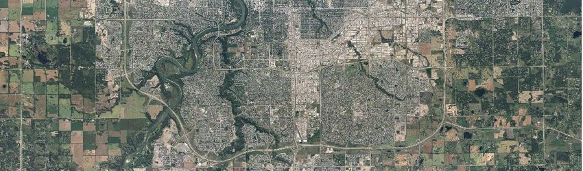
City of Edmonton
Annexation Areas, Leduc County
Environmental Reserve Analysis

               Prepared for:

City of Edmonton, Sustainable Development
              Edmonton, AB

           Solstice Canada Corp.

  10714‐124 Street, Edmonton, AB T5M 0H1

             DECEMBER 2016
19 December 2016

Adryan Wahl
Principal Planner
Sustainable Development
City of Edmonton
HSBC Bank Place
600, 10250 101 Street NW
Edmonton, AB T5J 3P4

Dear Mr. Wahl;

Re: Environmental Reserve Analysis, County of Leduc Annexation Area

We are pleased to provide the above‐named report, which documents the analysis of potential
environmental reserve (ER) lands and environmental sensitivities within the proposed County of Leduc
Annexation Area. The report summarizes not only the areas of lands that could be protected using the
Environmental Reserve process, but also the options available through policies of the City of Edmonton
to conserve lands not captured as ER. The report also compares City policies to standard municipal
development practices that rely mainly on the tools available through the Municipal Government Act and
other provincial legislation for environmental protection. Lastly, the results of the City’s Environmental
Sensitivities analysis were compared to past assessments of environmentally significant areas in Leduc
County, to determine how that inventory approach, and City’s natural areas policies might help conserve
and sustain the biodiversity and ecological services of this landscape.

We trust that the assessment will fulfill the requirements of the annexation process, and support other
work currently underway in support of your application. If you have any questions or comments regarding
the assessment, please contact the undersigned. We thank you again for the opportunity to participate in
this project and look forward to future opportunities.

Sincerely,

Solstice Canada Corp.

D.L. (Dee) Patriquin, Ph.D., P.Biol., R.P. Biol.
Sr. Environmental Scientist
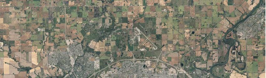
Table of Contents
1      Introduction .......................................................................................................................................... 1
    1.1        Project Scope ................................................................................................................................ 1
    1.2        Objectives...................................................................................................................................... 1
2      Methods ................................................................................................................................................ 4
    2.1        Study Area ..................................................................................................................................... 4
    2.2        Mapping Environmental Reserve Lands ....................................................................................... 5
       2.2.1           Policy Context ....................................................................................................................... 5
       2.2.2           Environmental Reserve Identification .................................................................................. 6
    2.3        Literature Review of Past Assessments ........................................................................................ 7
3      Assessment Results ............................................................................................................................... 8
    3.1        Potential Environmental Reserve Lands ....................................................................................... 8
    3.2        Literature Review of Past Assessments ...................................................................................... 14
4      Conservation Recommendations ........................................................................................................ 16
    4.1        North Saskatchewan River Valley and Tributary Ravine Systems............................................... 16
    4.2        Cawes Lake and Irvine Creek Systems ........................................................................................ 17
    4.3        Wetlands ..................................................................................................................................... 18
5      Conclusions ......................................................................................................................................... 19
6      References .......................................................................................................................................... 20
Appendix A. Wetlands In Annexation Lands ............................................................................................... 21

List of Tables
Table 1. Environmental Reserve Dedication Areas (ha), under Provincial and City Policy Scenarios, for More
Permanent Wetlands (Class III and Higher) ................................................................................................ 11
Table 2. Total Wetland Area (Buffered by 10 m) in the Proposed Annexation Area, Outside Ravine Buffer
Areas ........................................................................................................................................................... 11

List of Figures
Figure 1. Annexation Area Location .............................................................................................................. 3
Figure 2. Annexation Area; Potential Environmental Reserve Lands (Class III and Higher Wetlands) ....... 12
Figure 3. Annexation Area: Identifying Class II Wetlands for Provincial Compensation ............................ 13
Figure 4. Fiera (2015) Leduc County Environmentally Significant Areas Study compared to results of
Westworth and Associates (1990) study. (from Fiera 2015) ...................................................................... 15

                                                                                 i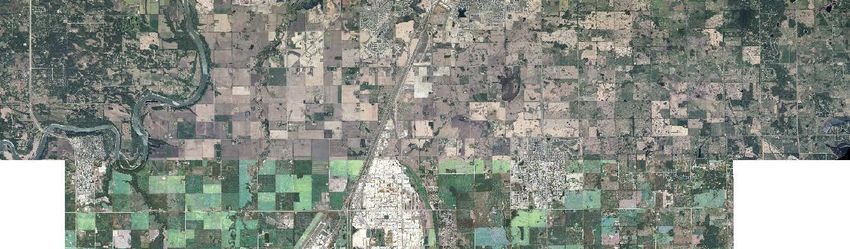
1 Introduction
1.1 Project Scope
On 5 March 2013, the City of Edmonton’s Council passed a motion to begin a municipal annexation
process with Leduc County. Annexation procedures are outlined in the Municipal Government Act and the
Municipal Government Board (MGB) Annexation Procedure Rules (2013). The procedures include
requirements for negotiations with the municipality (ies) to be annexed and assessment of the benefits
(financial or otherwise) of annexation. In accordance with this process, the City of Edmonton sent a Notice
of Intent to Annex to the two affected municipalities (Leduc County and the Town of Beaumont), and
other affected boards and agencies. Negotiations regarding the annexation began after notification and
various assessments of annexation have been completed or were underway. These discussions and
background reports will support the formal annexation application to the Municipal Government Board,
who will use this information as a basis for a recommendation on annexation to the Provincial Cabinet.
The City of Edmonton commissioned an assessment of the environmental sensitivities within the
annexation lands in June 2016. The annexation study area was added to the City of Edmonton’s
Environmental Sensitivities Project, already underway, to help the annexation team identify areas of
ecological value and to quantify the developable land base within the proposed annexation area.
Specifically, the Environmental Sensitivities Project for the Leduc annexation lands had three objectives:
1. To collect environmental information, in GIS format, that could be used in the Growth Study
update exercise currently underway by another consultant to identify potential Environmental
Reserve (ER) lands (i.e., hydrological and other natural features).
2. To demonstrate a thorough understanding of the present land inventory, including
environmental sensitivities, within the proposed annexation lands.
3. To incorporate that information into a general plan to preserve important natural features and
ecological systems, supported by policies and best practices.
The assessment examined potential ER lands within the two proposed annexation areas within Leduc
County (Figure 1), and evaluated environmental sensitivities within a larger, regional study area
incorporating a larger potential annexation area plus a 3.2 km buffer. The results of the assessment in the
larger regional study area are discussed in the Environmental Sensitivities Project report (Solstice 2016).
The 3.2 km buffer was consistent with that applied to the City of Edmonton Environmental Sensitivities
Project area, and ensured continuity with that planning area and consideration of environmental features
immediately beyond the annexation lands.
1.2 Objectives
Specific objectives of this project included the following:
Classify and delineate natural area features that could be taken by the City or the Province as
Environmental Reserve, and document in Excel table and spatial form. The data will provide the
Growth Study with an updated estimate of the developable area within the annexation lands (the
gross annexation area, minus lands likely to be taken as Environmental Reserve).
Map the Environmental Sensitivities of the annexation area, identified through the same
methodology applied to the City of Edmonton’s Environmental Sensitivities Project. This
1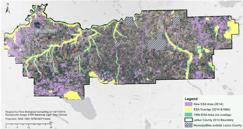
information would support future conservation planning, in the event of successful annexation
(results to be documented within the Environmental Sensitivities Mapping Project report)
Document analysis results in a final report that demonstrates an understanding of the
environmental sensitivities in the annexation area, and their local, regional or provincial
significance, and the capability of the City to plan development that would balance need for
growth and preservation of important ecological features and ecosystems.
Accordingly, this report summarizes the methods used to delineate and classify natural features according
to provincial planning standards (e.g., the Municipal Government Act, Water Act) and to quantify potential
environmental reserve lands. It also summarizes the policy and planning tools currently available to City
Planners to conserve environmentally sensitive features, highlighting areas in which the City policy may
offer enhanced protection (i.e., beyond current minimum Provincial standards). The report below outlines
the methods and results of this assessment process. Methods used to complete the environmental
sensitivities analysis, and results of the analysis are contained in the final Environmental Sensitivities
Project report (Solstice, 2016; under separate cover).
2
¬        ,
                                                                                                       ,
                                                                                                      !\

LEGEND                                       Figure 1. Annexation
Total Annexation Area
       Southwest Annex Area
                                             Areas and Study Area
                                   DATE:               PROJECT CODE:    PROJECTION:       SCALE:
                                   DECEMBER 06, 2016       16-3086-23     NAD83 3TM 114            1:225,000
       Southeast Annex Area
       Study Area
       City of Edmonton Boundary
2 Methods
The annexation assessment built on the concurrent City of Edmonton Environmental Sensitivities Project
(Solstice, 2016), which aimed to map natural features within the City and rank them for future
management focus. That project developed a methodology to assess sensitivity based on an analysis of
data describing valued environmental features, compiled from existing, publicly available datasets (e.g.,
species at risk, special habitats, cultural sites and protected areas), City‐owned data, and project‐specific
data created using GIS analysis techniques (Solstice, 2016). The approach combined the compiled
datasets, categorized as environmental assets, threats and development constraints, to determine
relative environmental sensitivity for natural features within the City study area. Extension of the City
study area to include the proposed annexation lands provided project‐specific data that could identify
environmental reserve lands at fine‐resolution (i.e., hydrology, wetlands, ravine mapping), and map
environmental sensitivities across both the City and the annexation lands. These environmental features
were then compared to past mapping of environmental features, to evaluate the improvements offered
by this new technique, and implications for future management after annexation. A description of the
study area context, and the specific methods used for this assessment are provided below.
2.1 Study Area
This assessment involved two scales of analysis. First, potential ER lands were identified within the
southeast and southwest corridor 2 annexation study areas and the airport lands to assist in annexation
discussions (Figure 1). The annexation component of the Environmental Sensitivities Project covered over
a much larger area that extended from the southern boundary of the City to the south boundary of the
airport lands, Nisku and Beaumont areas (see Environmental Sensitivities Project report).
The airport lands are included in the annexation proposal, but the City would not hold jurisdiction for land
use planning in that area. The airport lands are held by the federal government, and thus fall under federal
planning jurisdiction. This area was included in the analysis to ensure continuity of mapping natural
features that might extend across both federal and municipal jurisdiction (e.g., streams). The southeast
and southwest corridor 2 annexation areas represent the main area for future development under
municipal direction, and thus were the focus of the annexation proposal. The two proposed annexation
areas lie entirely within Leduc County. The southeast annexation area lies north of Beaumont and captures
lands immediately south of the current City boundary (Figure 1). The southwest corridor 2 annexation
area is bounded to the east by Highway 2 and the North Saskatchewan River and a tributary ravine to the
northern and northwest. The southern boundary follows the border of the Edmonton International
Airport and Highway 19.
The annexation lands lie within the Aspen Parkland Natural Subregion; an area historically vegetated with
interspersed aspen groves and fescue grasslands (Natural Regions Committee, 2006). Fertile soils led to
extensive clearing for agricultural purposes during early settlement, and today, natural habitat is limited
to small patches of native upland habitat and wetlands, in areas where terrain or drainage limited
agricultural use. To the east is the western edge of the Beaver Hills moraine, an undulating to rolling
landscape, but the annexation area itself is relatively level to undulating (Bayrock and Hughes, 1962). Its
physiography resulted from sediments deposited in glacial Lake Edmonton (Bayrock and Hughes, 1962).
The headwaters of Whitemud, Blackmud Irvine creeks originate in these lands and the surface drainage
from these smaller tributary streams contributes flows to each creek. Deep, wide ravines developed
4where Whitemud and Blackmud creeks near the North Saskatchewan River, and extend some distance
south (particularly along Whitemud Creek). Irvine Creek, in contrast, occupies a shallow channel and the
adjacent, relatively flat lands have often been cleared. Beyond the creeks, the land is relatively flat and
wetlands have formed in shallow depressional areas, resulting in an agricultural landscape interspersed
with wetlands, ravines and small remnant forest patches.
2.2 Mapping Environmental Reserve Lands
2.2.1 Policy Context
Environmental reserve (ER) lands are typically identified in an Area Structure Plan but finalized and
dedicated by the municipality at the time of subdivision. Typically, ER dedication is based on presence of
features that the Province and/or municipality wishes to conserve (e.g., ravines, waterbodies and other
drainage courses), or hazard lands on which development may be at risk (e.g., steep slopes, floodplain),
as defined by the Municipal Government Act (MGA, 2000, amended to July 2016). In the case of wetlands,
the provincial Water Act and Wetland Policy (2013) outline specific conservation goals (and process).
Under the provincial Water Act, development affecting wetlands and other waterbodies requires
government approval, following the process outlined in the provincial Wetland Policy. The policy
addresses impacts to all wetlands classified under the Alberta Wetland Classification System (2015)1 (i.e.,
temporary through permanent marshes, treed swamps, and peatlands), and any wetland loss due to
development must be compensated. As a starting point then, mapping of potential ER lands should
consider all features defined under both the MGA and the Water Act and associated policy.
Specifically, the MGA Part 17: Section 664 defines environmental reserve lands as follows:
Subject to section 663, a subdivision authority may require the owner of a parcel of land that is
the subject of a proposed subdivision to provide part of that parcel of land as environmental
reserve if it consists of:
a) a swamp, gully, ravine, coulee or natural drainage course;
b) land that is subject to flooding, or is in the opinion of the subdivision authority, unstable; or
c) a strip of land, not less than 6 metres in width, abutting the bed and shore of any lake, river,
stream or other body of water for the purpose of (i) preventing pollution, or (ii) providing public
access to the bed and shore.
In practice though, other factors influence the dedication of ER, including municipal policy regarding
environmental conservation and the feasibility of protecting all wetlands on a given, developable site.
Smaller waterbodies cannot always be conserved within developing lands and both the developer and
municipalities will often focus on larger, more permanent wetlands and streams for retention under ER
designation. In particular, temporary marsh wetlands (wetlands that are wet for only a short period during
the spring or after rain, also called Class II wetlands under the Stewart and Kantrud (1971) system) could
1
The Province formerly applied the Stewart and Kantrud (1971) wetland classification system and for ease of
reference, we have used that more familiar former classification in this assessment.
5be taken as ER if deemed necessary after study, but are not always conserved. Their loss requires
compensation under the Wetland Policy, but for purposes of calculating ER, they are not as likely to be
dedicated at time of subdivision as more permanent wetlands (Class III or higher, under the Stewart and
Kantrud (1971) system).
In addition, municipalities may dedicate buffers as Environmental Reserve that are greater than the
minimum 6 m outlined in the MGA, to meet local water quality, public access, or flood prevention
objectives. The City of Edmonton Natural Area Systems policy (C531) requires a minimum 30 m buffer on
streams and wetlands for pollution prevention as well as a setback from unstable slopes. The City of
Edmonton Top of Bank Policy specifically applies a minimum 10 m public access setback from the crest of
ravines and the North Saskatchewan River valley. A geotechnical study may recommend a greater setback
based on slope stability findings. Because these proposed setbacks are greater than the provincial
minimum, we developed ER dedication estimates based on (1) minimum provincial standards and (2) the
Environmental Reserve guidelines applied by the City of Edmonton. Provision of both dedication estimates
allowed for comparison of City and the minimums set by Provincial legislation.
2.2.2 Environmental Reserve Identification
Based on the policy context outlined above, we developed provincial and City ER dedication scenarios
based on delineation of ravines, wetland mapping and stream mapping and the applicable buffers. Stream
channels, wetlands and ravines were identified through Geographic Information Systems (GIS) analyses
completed as part of the City of Edmonton’s Environmental Sensitivities Project (Solstice, 2016).
GIS drainage analysis helped improve existing provincial hydrology mapping (Alberta’s 1:20,000
topographic provincial base mapping) in the annexation study area lands, providing a complete network
analysis based on the Horton classification system at 1:5,000 scale. To remain consistent with standard
land use planning approaches that focus on intermittent and permanent watercourses, we included only
the North Saskatchewan River, Whitemud and Blackmud Creeks and their immediate tributaries, larger
watercourses that have been considered in the City’s drainage and land use planning. Irvine Creek and its
tributaries were also mapped in the larger Environmental Sensitivities Project. Wetlands were mapped
according to both the Stewart and Kantrud (1971) classification system, and the new provincial Wetland
Classification System (2015). Although similar, the provincial system better differentiates the range of
wetland types found in the Edmonton area, and it is applied in the provincial Wetland Policy. Classification
allowed differentiation of a ‘best‐case’ provincial and a more typical development scenario for ER
dedication. The Wetland Policy requires conservation of all types of wetlands classified under the
provincial system, but in practice, most temporary graminoid marshes (Class II temporary wetlands under
Stewart and Kantrud, 1971) are not retained after development. Their loss is instead compensated, and
generally, only more permanent wetlands are retained as ER. Accordingly, we provided separate analyses
showing ER dedication under the provincial and City dedication scenarios, with all provincially regulated
wetlands (as listed in the provincial classification system and including temporary marshes), and without
the temporary marshes, respectively.
To identify ravines, we used LiDAR data slope and contour analysis to identify the crest of slope (i.e., point
where slope is greater or equal to 5 °). We mapped ravines based on the break in slope from level to
6sloped ground, using the 5° contour line derived from terrain mapping done for the Environmental
Sensitivities Project. This provided a nearly continuous demarcation of the crest of ravine slopes, which
allowed us to extend previous mapping along Whitemud and Blackmud Creeks and associated tributaries.
It also allowed us to refine mapping of the North Saskatchewan River valley and its smaller tributary
ravines. To fill gaps in the contour linework, we manually digitized contours using a ‘shadow’ terrain map
showing relief, orthoimagery and SPOT imagery. Where contours extended through built up areas (e.g.,
houses, road crossings), we manually adjusted boundaries to avoid bisection of infrastructure and to
accommodate breaks in ravines due to road and bridge embankments.
To avoid double counts of overlapping buffers, where ravines, streams and/or wetlands were contiguous,
we controlled for spatial overlap within the GIS delineation and attributing process. Ravine mapping at
the upstream, tapering end stopped at the 5° slope line to delineate clearly the break between uplands
and ravine. For streams that ran through both uplands and ravines, only the segments through uplands
were included in the ER calculation. Where an on‐stream wetland had developed adjacent to a stream,
the wetland was captured in the wetland buffer rather than as part of the stream ER. If the wetland and
buffer were contained within a ravine, only the ravine ER area was counted.
Accordingly, ER mapping analysis generated estimates that allowed the City conservation practices to be
compared to that minimally applied by most municipalities under provincial policy. This included
consideration of the compensation requirements for all wetlands covered under the Wetland Policy (i.e.,
including temporary marsh / Class II wetlands), and the estimated ER dedication under the provincial and
City policy set‐back scenarios, and including the more permanent wetland classes (i.e., seasonal marshes
/ Class III wetlands or more permanent classes). Specifically, the ER dedication compared two scenarios:
Provincial scenario: 6 m buffer to wetlands and streams, no buffer on ravines
City scenario: 30 m buffer to waterbodies, 10 m buffer along ravines.
2.3 Literature Review of Past Assessments
Past assessments within Leduc County mapped environmentally significant areas within the proposed
annexation study areas, following various protocols (Westworth and Associates, 1990; Fiera 2015). In both
cases, significance was based on ecological principles (e.g., size, intactness, connectivity) and valued
environmental characteristics, such as uniqueness or presence of species of concern. Although the
methods of analysis and weighting of those factors differed slightly in each assessment, they offered a
basis for comparison to the ER estimate and to the environmental sensitivities mapping. To provide that
background context, we reviewed the results of the more recent assessment (Fiera, 2015) as well as the
methods used in the assessment. This review provided both indication of known sensitivities (and a check
for our own assessment work), and means to compare our results to past studies.
73 Assessment Results
3.1 Potential Environmental Reserve Lands
Mapping of potential environmental reserve lands identified ravine, stream and wetland reserve lands
under the provincial and City of Edmonton scenarios within each proposed annexation area and within
the airport lands. It also identified all wetlands for which compensation would apply, including temporary
marshes (Class II wetlands). This mapping was based on analysis of remote sensing data and did not
include the site‐specific survey applied during the Area Structure Plan stage of development. Accordingly,
these potential ER and wetland compensation estimates should be considered a preliminary analysis that
would require further assessment to confirm a more specific, future dedication (e.g., during development
planning). As outlined in the methods, the two ER scenarios differed in terms of the buffer applied to each
feature:
Provincial scenario: 6 m buffer to wetlands and streams, no buffer on ravines
City scenario: 30 m buffer to waterbodies, 10 m buffer along ravines.
Results of the analysis found that the lower order streams (Horton classes 4 and 5) and associated ravines
were the most abundant feature in the southwest corridor 2 annexation area, relative to ER dedication
and thus drove a significant proportion of the potential ER dedication (Table 1, Appendix A). In the
southeast area, in contrast, streams and wetlands represented the dominant part of the potential ER
dedication (Table 1, Appendix A). Most ravines were associated with larger order streams such as
Whitemud Creek and Blackmud Creek, which have created wide and deep valleys supporting mature
forest and wetlands in oxbows and floodplains (Figures 2 and 3). These stream and riparian wetland areas
were captured in the estimated ER dedication for ravines. Upper Blackmud Creek is not confined within a
ravine and as a result, has experienced considerable modification and disturbance within the riparian
zone. In some areas, the creek has been channelized, altering flow regime and habitat conditions. Similar
changes have affected the section of Irvine Creek that flows through the southeast annexation area.
Streams with defined channels (Horton classes 4 and up, typically) and permanent wetlands are often
retained in developed lands, mainly due ownership of the bed and shores of such waterbodies by the
province. Under the Alberta Public Lands Act, the bed and shores of permanent waterbodies cannot be
modified, unless under approval, and ownership remains under the Crown. Although the bed and shores
of such waterbodies cannot be altered, the adjacent riparian lands have no such protection, which has led
to the disturbance seen on the upper reaches of Blackmud Creek. ER dedication offers protection of not
only the stream channel, but the riparian buffer zone so important to steam health.
Temporary marsh wetlands though, are often lost in development scenarios, and rarely conserved as ER,
despite their abundance. The areas shown in Tables 1 and 2 highlight the difference between the
conserved and compensated wetland areas under ER and provincial Wetland Policy, respectively.
Temporary marsh wetlands (Stewart and Kantrud (1971) Class II wetlands) contributed an extensive area
to the overall wetland total within the three annexation areas (Table 2, Figure 3). These wetlands
represented most wetland habitat in terms of areal extent, relative to the next most abundant wetland
class in all three annexation areas (Table 2). Diversity of wetland types was higher in the southeast
annexation area (Table 2, Appendix A), and conservation of the more permanent wetlands (seasonal,
8semi‐permanent and permanent wetlands, and bogs) as ER lands will help protect wetland habitat
diversity. The loss of temporary marsh wetlands, and overall wetland area can be addressed through
provincial compensation programs (although replacement is not often in the same area), as well as other
City of Edmonton conservation policy.
Typically forming in the shallow depressions so common on undulating and rolling landscapes, temporary
marshes hold water only briefly in spring, or after summer rains. During their prolonged dry draw‐down
period, soil is dry enough for cultivation (in cropped areas) and in naturally vegetated context, the basin
fills with sedges and other facultative wetland grass species tolerant of moist soils. From the land owner’s
(or developer’s) perspective, they lack the open water characteristic of ponds or lakes and so, historically,
have been viewed as developable lands. Although their hydrological role is replaced on‐site through
constructed stormwater management facilities (SWMFs) in urban development, the wetland habitat is
typically replaced off‐site through the provincial compensation process. The perceived value of temporary
wetlands in local hydrology and ecological function is changing now with the introduction of the provincial
Wetland Policy, but they are still typically considered ‘developable area’, and would not likely be captured
as ER during the standard development process. Accordingly, for purposes of the annexation process, the
developable lands calculation would exclude temporary wetlands, as was done here. There may be cases
where temporary wetlands offer other values though and ultimately, dedicated lands would be best
determined at the Area Structure Planning stage, post‐annexation.
Regardless, the potential wetland compensation area offered by lost temporary marsh provides an
opportunity to retain, enhance or replace habitat elsewhere in the future development area, provided
municipal policy promotes such activity. Abundant temporary marsh occurs across the entire proposed
west corridor 2 and southeast annexation areas (558.4 ha and 312.6 ha, respectively, Table 2), and would
potentially require compensation (off‐site) to the province. The City of Edmonton has explored various
mechanisms for retention of wetland habitat within City lands, through drainage design (as naturalized
stormwater facilities), or through incorporation of intact wetlands in the drainage system. Land use
development policies that require conservation of higher value natural areas in the design of new
development offer other opportunities to sustain wetlands (and other habitat) during the development
process. Such policies are discussed further in Section 3.3 below, regarding environmental sensitivities.
Although temporary marsh wetlands may not be conserved as ER, other means of conservation have been
developed in City policy and are currently being implemented in the development process. There is
potential to conserve these wetlands after annexation, or replace their functions, through means other
than ER, given Edmonton’s current conservation ‘toolbox’.
Not surprisingly, there is a considerable difference in ER dedication between the minimum provincial
standard and the City policy approach. The City has adopted a buffer for waterbodies well supported as a
minimum width for protection of water quality by other jurisdictions (e.g., Connecticut River Joint
Commissions, 2000; Fishcher et al, 2000; Young et al 1980) and consistent with other municipal pollution
setback policy, based on additional research conducted by the City (pers. comm., C. Shier). This size of
buffer will also protect some riparian habitat. The minimum 6 m buffer allowed in the MGA provides
separation of developed lands from wetland habitat, but limited capacity to sustain the ecological health
of wetlands.
The City’s Top‐of‐Bank Policy and Natural Area Systems Policy (C531) both acknowledge the risk
associated with development along the steep slopes of the river valley and associated ravines. The 10 m
9setback is a minimum distance for public access; the buffer increases for moderate (15° to 30°) to steep
(>30°) slopes, and based on geotechnical assessments conducted at the time of development. Within the
annexation area, these increased set‐backs would apply to some locations along the North Saskatchewan
River, Whitemud Creek and Blackmud Creek. The set‐back can also serve as a buffer for human
disturbance. Ravines and the river valley offer hiding cover and habitat to more mobile wildlife species
that can support movements through landscapes. In a developed context, such areas are often critical to
support habitat connectivity that promotes genetic exchange, distribution of young, and ultimately, a
sustainable regional population of wildlife.
Given the ecological approach applied in City ER dedication policies, the ER estimate that would be applied
under the City policy scenario will conserve both natural areas and ecological function more effectively
than would application of the provincial standard, as shown in Table 1 below.
10Table 1. Environmental Reserve Dedication Areas (ha), under Provincial and City Policy Scenarios, for
More Permanent Wetlands (Class III and Higher)
Annexation RAVINE STREAM WETLAND Total Total
Area Possible ER Annexation
(ha) Area (ha)
City Policy Scenario (30 m buffer on waterbodies, 10 m buffer along ravines)
Southwest 537.7 88.0 57.7 683.4 9,130.2
Corridor 2
Southeast 8.7 90.2 232.6 331.5 2632.1
Airport 30.5 58.5 28.4 117.4 2,830
Total 576.9 236.7 318.7 1,132.2 9,506
Provincial Policy Scenario (6 m buffer on waterbodies, no buffer on ravines)
Southwest 467.8 17.7 22.2 507.7 9,130.2
Corridor 2
Southeast 5.2 18.7 142.2 166.1 2632.1
Airport 19.7 11.8 11.7 43.2 2,830
Total 492.7 48.2 176.1 717.0 14,592.3
Table 2. Total Wetland Area (Buffered by 10 m) in the Proposed Annexation Area, Outside Ravine Buffer
Areas
Southwest Southeast Airport
Corridor 2 Annexation Annexation
Wetland Type Annexation Area Area Study Area
Stewart and
AWC Class AWC Type
Kantrud Class Area (ha) Area (ha) Area (ha)
Marsh Temporary II 558.5 312.6 136.2
Marsh Seasonal III 0 1.0 0
Semi‐
Shallow (A)
Permanent IV 0 98.93 0
Shallow (B) Permanent V 4.0 8.63 3.5
Swamp Seasonal VIII 9.1 11.9 4.6
Bog X 1.2 0.86 0.0
Total 572.8 433.9 144.3
11¬ ,
!\
LEGEND Notes: Figure 2. Potential Environmental
Ravine V (Shallow Open Water/Permanent) Strahler Stream Class Total Annexation Area The buffers for streams; wetlands Reserve Lands (Class III and Higher Wetlands)
Stewart and Kantrud Class VIII* (Swamp/Seasonal) 5 Southwest Annex Area and ravines are not shown on this figure, DATE:
DECEMBER 06, 2016
PROJECT CODE:
16-3086-23
PROJECTION:
NAD83 3TM 114
SCALE:
1:65,000
but were included in area calculations in
III (Marsh/Seasonal) X* (Bog) 6 Southeast Annex Area
the report.
IV (Shallow Open Water/Semi-Permanent) Study Area *Classes not included in the Stewart and
Kantrud system.¬ ,
!\
LEGEND Notes: Figure 3. Potential Environmental
Ravine Strahler Stream Class Total Annexation Area Study Area The buffers for streams; wetlands Reserve Lands (Class II Wetlands)
Stewart and Kantrud Class 5 Southwest Annex Area and ravines are not shown on this figure, DATE: PROJECT CODE: PROJECTION: SCALE:
DECEMBER 06, 2016 16-3086-23 NAD83 3TM 114 1:65,000
but were included in area calculations in
II (Marsh/Temporary) 6 Southeast Annex Area
the report.
*Classes not included in the Stewart and
Kantrud system.3.2 Literature Review of Past Assessments
Two past assessments mapped environmentally significant areas within Leduc County (ESAs; Westworth
and Associates, 1990; Fiera 2015) and provided a means of assessing the significance of the potential ER
lands. The approach used in both cases followed contemporary conservation practice, identifying sites
containing valued environmental resources or likely to provide important ecological functions. Fiera
(2015) emphasized aquatic habitats more than did the Westworth & Associates (1990) study,
acknowledging the recent provincial focus on wetland loss. The Fiera (2015) study completed a wetland
mapping exercise intended to expand on the provincial Wetland Inventory, thus mapping areas that might
potentially be considered as ER. It did not specifically enhance ravine mapping, instead relying on existing
boundaries delineating the North Saskatchewan River and tributary valleys.
Both studies identified the North Saskatchewan River valley and major ravine systems, and large
permanent lakes as significant sites based on their prominence as permanent physical features, factors
that would support future ER dedication. This is consistent with past planning and provincial management
within the region. The North Saskatchewan River Valley and its tributaries have been considered
significant environmental resources within the Edmonton region in several environmental inventory and
planning studies (e.g., EPEC 1981; City of Edmonton, 1992; RVA 2008). The Ribbon of Green (City of
Edmonton, 1992), the River Valley Alliance Plan of Action (RVA 2008) and the Capital Region Plan have all
acknowledged the environmental significance of these major features, based largely on their
geomorphology (i.e., deeply incised ravines and associated permanent watercourse).
The information driving the Fiera (2015) assessment comprised publicly available data (ACIMS, FWMIS)
and new data derived from analysis using GIS techniques (i.e., wetland analysis, hydrology, land cover).
Wetlands delineated in this analysis had an estimated accuracy of 97%, but wetland classes could be
assigned with only limited confidence (about 50%) due to limitations of the analysis technique. Similarly,
land cover mapping completed for the assessment had an estimated accuracy level of 53.5% on average,
mainly due to misidentification of anthropogenic features and of aerial imagery artifacts (shadow, poor
color separation). As a result, land cover was categorized in only five generalized cover types: agricultural,
forest, water/wetland, open and bare ground. Natural habitats were not identified by dominant
vegetation type (e.g., spruce, aspen) or form (e.g., grassland, pasture, manicured), thus preventing
identification of unique vegetation communities. The wetlands mapping appears to have underestimated
the extent of wetlands across the study area, and classification errors would limit application of this
mapping to ER dedication estimates, or comparisons with this current study.
The approach was thus limited by the lack of ground‐truthing and the level of detail offered by land cover,
hydrology and wetland mapping. The approach also focused on identification of significant sites, areas
with highly valued environmental resources from the perspective of Leduc County and in some cases,
provincial management priorities (e.g., for water resource management). This is consistent with ESA
studies, which seek to identify sites with higher environmental value. Neither Fiera (2015) nor Westworth
& Associates (1990) rated the other natural areas found within County lands, and thus provided no
management guidance for lands that retained lesser‐valued natural habitat, including wetlands and
smaller ravines. This highlights a key issue with past environmental mapping within the Edmonton region,
and the ESA approach specifically. An ESA study focuses attention on exemplary sites, but provides no
insight on environmental management across the remaining landscape. This prevents identification of
14sites that may serve as connective habitat or buffers to those valued sites, factors that could influence ER
dedication decisions, particularly when applying wetland buffers.
Effectively, the ESA study approach limits the ability to manage environmental features and ecological
functions at the landscape level, an approach more likely to sustain both of these values. The City’s
Environmental Sensitivities Mapping Project will provide this level of additional detail, which can help to
inform ER dedication at the Area Structure Planning, and individual development scale.
Figure 4. Fiera (2015) Leduc County Environmentally Significant Areas Study compared to results of
Westworth and Associates (1990) study. (from Fiera 2015)
154 Conservation Recommendations
The mapping of ravine, stream and wetland areas in this study provided finer resolution data than
previous ESA mapping studies within Leduc County, the only comparator currently available. In particular,
it extended the mapping of Whitemud ravine to the full length of the ravine, almost to the airport lands,
and refined the resolution of the previously mapped stream and wetland network. Visualization of the full
extent of natural features mapping is an important first step in conservation of ecologically important
features, allowing appreciation of the network as a whole. Quantification of those features, in terms of
total area, and type can further raise awareness of the remaining resources, particularly in landscapes
that have experienced substantial land conversion to anthropogenic uses.
Mapping of potential ER lands alone provides means to plan for future protection of these features by
identifying areas that should, or could be conserved. Existing City of Edmonton policies, including the Top
of Bank Policy and the Natural Area Systems Policy (C531) provide additional criteria for ER dedication
that can be applied to help buffer retained natural areas from pollution, slope failure, erosional issues and
other disturbances. However, dedication alone will not ensure sustainability of these areas. Ecologically,
such sites depend on functional connections to ensure that local hydrology, biodiversity, nutrient cycling
and other ecosystem level processes can be maintained. To sustain these sites at the ecosystem level
requires an understanding of the key features across the annexation lands, and the linkages and
interactions among them, including connections that may lie beyond these annexation areas themselves.
The sections below describe three of the key features within this landscape and the functional connections
that are important to their sustainability.
4.1 North Saskatchewan River Valley and Tributary Ravine Systems
The risk in delineating any management area is the exclusion of other associated natural features beyond
a jurisdictional boundary. Nowhere is this more apparent than with the North Saskatchewan River Valley
and its tributary valleys in the southwest corridor 2 annexation area. Figures 2 and 3 show the Whitemud
Ravine and the river valley areas as separate entities, which suggests independence. Only a short distance
north along the Whitemud Ravine, however, lies the confluence of Blackmud Creek, and further along,
the confluence with the North Saskatchewan River. The river valley, of course, extends well‐beyond the
west annexation area to the east and west. These seemingly independent features are part of a larger
functional ecosystem that supports both locally and regionally important ecological functions, and valued
ecological goods and services. Importantly, not all of this system is protected by steep slopes that would
dictate ER dedication, and thus the aquatic and terrestrial systems linked comprising this linked system
are at risk from future development.
Fish and other aquatic species can move along the length of this system, a level of connectivity recognized
in the Alberta Code of Practice for Watercourse Crossings, which considers both creeks to be fish‐bearing
(Class B and C, depending on the reach). Similarly, highly mobile terrestrial mammals such as deer will use
these ravines and the river valley to link required habitat comprising a much larger home range. Smaller
mammals and various bird species will use these corridors to access mates and disperse, or in the case of
plants, propagate and spread, and ultimately, maintain genetic diversity at the regional level. Surface
water collected in smaller wetlands across this landscape buffers the creeks by storing run‐off, filtering
nutrients and feeding groundwater systems. Activities on the uplands areas that form the headwaters of
16these creeks and along the ravine and valley edges can have dramatic influence on local hydrology,
terrestrial and aquatic habitat and landscape level connectivity.
Yet examining Figures 2 and 3, two aspects of this part of the ravine and river valley system become
immediately evident:
only in areas with steeply sloped ravines and valleys has a vegetated buffer development
maintained around the river, creeks or their headwater streams, and
the abundant wetlands across this landscape comprise (overwhelmingly) temporary marshes
(Class II ponds) that are often lost during development.
Although within the City of Edmonton, both Whitemud and Blackmud creeks flow through deep ravine
systems that have protected their terrestrial and aquatic habitats from disturbance, in the annexation
lands, such protection applies only to Whitemud Creek. Blackmud Creek flows through an incised channel,
but over otherwise level terrain. Agricultural development has extended to the edge of the incised stream
channel in places. Some reaches have been realigned into channelized ditches. Yet this creek maintains
continuity with the waterbodies of the Gwynne channel southeast of Leduc, including Telford and
Saunders lakes. Wetlands that capture surface water flows on the relatively flat tablelands above the river
valley, Whitemud Ravine and Blackmud Creek provide aquatic habitat, nutrient capture and help sustain
local hydrology (including flood mitigation and release to local tributary headwaters).
Ecosystem level conservation recommendations that could help sustain the ecological functions (and
goods and services) associated with this landscape include the following:
Maximize vegetated buffers along all streams claimed as ER, to prevent water pollution, provide
wildlife habitat, prevent evapotranspiration and maintain existing biodiversity.
Consider opportunities to restore vegetated buffers along streams disturbed by past
development, including those intermittent streams beyond the ravines and river valley that
comprise the headwaters of Whitemud, Blackmud and the North Saskatchewan River.
In long‐range planning, locate land uses with potential to release pollutants away from streams
and larger wetlands, and the ravines and river valley to reduce risk of spills and releases to
downstream habitats.
Similarly, consider options to reduce loss of wetland or substantial alteration of natural hydrology
in long‐range planning and localized development (e.g., incorporating LID principles for
stormwater management, reducing development density in areas with abundant wetlands, see
wetland discussion below).
4.2 Cawes Lake and Irvine Creek Systems
Cawes Lake and the Irvine Creek system in the southeast annexation area occupy landscape that posed
few limitations for past agricultural clearing and long‐term agricultural use, and associated impacts on
hydrology and biodiversity. Stantec (2014) reviewed the effect of past development on watershed level
function, and implications under future development.
Although part of the Beaver Hills Moraine, the hummocky terrain is relatively low relief and there were
no ravines to force a set‐back from streams, wetlands or the lake, and as a result, clearing extended to
the shore of most waterbodies. In some areas, drainage was altered to realign Irvine and tributary
streams, or drain larger temporary marshes through which these streams flow (Class II wetlands, Figure
173). Parts of Cawes Lake itself have been cultivated and infilled, altering storage capacity, introducing
agricultural run‐off, facilitating establishment of non‐native and invasive species, and reducing other
wetland functions (including habitat provision, Stantec, 2014). Yet despite these past impacts, the area
supports a relatively high biodiversity and Irvine Creek and its tributaries are fish‐bearing (Stantec, 2014).
In the context of future development, this area is vulnerable, and will require both conservation and
restoration actions to retain its ecological values, and sustain important ecological services.
Cawes Lake and other wetlands in this area are shallow, and sensitive to changes in local run‐off, including
impacts of stormwater management associated with urban development (Stantec, 2014). Future
development may reduce flows supporting these waterbodies, resulting in additional drawdown, drying
and eventual succession to moist prairie or upland zones, and a loss of aquatic habitats. Because the
waterbodies in this area are headwaters that contribute to significant downstream systems (e.g.,
Blackmud Creek), sustaining (or restoring) local hydrology is important for many reasons, including
biodiversity conservation and flood mitigation. Irvine Creek supports low‐flow, and has required
maintenance to improve localized blockage and avoid upstream flooding (Stantec, 2014). This periodic
maintenance and past alterations along the creek and other tributaries have already impaired fish habitat
quality and contributed to other water quality issues, such as erosion and sedimentation during storm
events.
Development in this area offers opportunity to improve drainage conditions and habitat, hydrology and
other functional values, although not through traditional stormwater management approaches.
Apparently, the low discharge rate required to Blackmud Creek poses problems in terms of adequate
stormwater pond storage and potential for stream erosion during storm events (Stantec, 2014). Instead,
Stantec (2014) recommended a watershed level restoration approach that incorporates Natural Channel
Design and other restoration techniques in Irvine Creek and tributary streams. This would provide
adequate storage, moderate discharge rates and sustain aquatic and riparian habitat conditions within
this area, and in downstream habitats. Accordingly, a first step will be protection of the creek and
tributaries as ER, with an adequate vegetated or restorative buffer.
In terms of connectivity, these waterbodies and associated riparian zones can play an important role in
conjunction with other natural areas conserved within the City of Edmonton, and the Beaver Hills Moraine
lands within Strathcona County. Within this moraine landscape, complexes of wetlands and larger
waterbodies, including Cawes Lake support waterfowl and other water bird abundance and diversity, and
thus can play an important role in sustaining biodiversity at the regional level. Obviously, retention and
restoration of wetlands, and their local hydrology within this part of the moraine will be critical in
maintaining this ‘habitat level’ biodiversity.
4.3 Wetlands
A recurring theme in this analysis was the role of wetlands in supporting local hydrology, biodiversity and
key ecosystem services such as water filtration, nutrient capture, groundwater flow, and flood mitigation.
The ER analysis quantified the areal extent of wetland habitat across the three annexation areas. The
separation of seasonal marshes (Class III) and higher classes from temporary marsh (Class II) wetlands
highlighted the important role these smaller wetlands play in local hydrology, a role often impaired, or
lost during urban development. These smaller temporary ponds are widespread, and support shallow
groundwater flow through infiltration (as well as mitigating flooding) despite a relatively short period of
inundation. Impervious substrates block this link between surface and groundwater, and traditional
18stormwater controls may not necessarily recreate this pre‐development pathway of groundwater supply
(Dietz, 2007). For example, often stormwater ponds are clay‐lined, designed to hold and treat water
before release to downstream systems. This disruption to localized hydrology can contribute to drying of
shallow waterbodies, as has been described for the Cawes Lake area by others (Stantec 2014).
Low Impact Development (LID) strategies can offer a potential alternative to traditional stormwater
systems, providing better groundwater recharge as well as potential nutrient and water filtration
functions (Dietz, 2007). Well‐planned LID features can also offer aesthetic benefits, serving as amenities
in developed areas or buildings. Pervious substrates, bioretention and grassed drainage swales have been
incorporated into drainage standards in some Alberta municipalities (e.g., Parkland County, Strathcona
County) and green roofs can gain LEED accreditation for new developments. Such incentives can
encourage a shift away from traditional stormwater management, and can also reduce issues (and costs)
transferred to municipalities after development (e.g., nutrient loads, discharge control and flood
mitigation).
Of course, the simplest mitigation is to retain wetlands, or restore them, in place. The City has various
policy tools that can assist in not only conserving wetlands, but providing an adequate buffer for wildlife
habitat, pollution prevention, and other functions. Given the extent of Class II habitat across this area,
retention of available wetlands becomes even more relevant. The much larger, functional role of the Class
II wetlands, which are typically lost in development proposals, cannot be fully replaced by LID techniques.
Retention of the Class III and higher wetlands that can be more readily conserved under City or other
supporting policy tools (e.g., Water Act, Wetland Policy, and proposed Municipal Government Act
conservation tools) maximizes the opportunity to conserve both natural habitat and hydrological
functions. Futher, well planned LID techniques can work in conjunction with conserved wetlands to retain
function at a broader scale, for a system level conservation approach.
5 Conclusions
The ER estimate provided in this review highlighted the abundance of wetlands, and expanded on past
mapping of ravine and stream areas. Awareness of the location and extent of these resources, and their
linkages to other regionally important ecological functions can play a critical role in retaining biodiversity
and ecological goods and services at a system level. The City has a variety of policy tools designed to
manage natural features, including ER lands, at this broader ecosystem level, and is well‐positioned to
guide future development of the annexation areas in a manner that will sustain these environmental
assets. Conservation recommendations provided here offer additional suggestions that could be
incorporated into long‐range and local development planning. The environmental sensitivities mapping
for these lands and the City (as part of the City’s Environmental Sensitivities Mapping project) will further
aid in planning for conservation at the ecological network level.
A limitation of this analysis is the reliance on remote sensing and GIS based analysis. Site specific
investigation, such as the field surveys and biophysical assessments completed in support of Area
Structure Planning and development planning will confirm mapping and refine the ER dedication at a
future development stage. Such planning offers other opportunities to incorporate suitable local
mitigation measures that can help retain regional connectivity, hydrology and biodiversity.
196 References
Bayrock, LA and Hughes GM. (1962). Surficial geology of the Edmonton District, Alberta. Preliminary
Report 62‐6. Edmonton, AB: Research Council of Alberta
Connecticut River Joint Commissions. (2000). Introduction to riparian buffers. River Banks and Buffers
Fact Sheet, No. 1. Charlestown, NH: Connecticut River Joint Commissions of NH & VT.
Dietz, ME. (2007). Low Impact Development practices: A review of current research and
recommendations for future directions. Water Air Soil Pollut. 186: 351‐363
Edmonton Parks and Recreation. (1992). North Saskatchewan River Valley and ravine systems master
plan. Ribbon of Green. Edmonton, AB: City of Edmonton Parks and Recreation.
[EPEC] EPEC Consulting Western Ltd. 1981. North Saskatchewan River Valley & Ravine System
Biophysical Study. Prepared for City of Edmonton, Parks and Recreation Department.
Fiera Biological Consulting Ltd. (2015). Leduc County Environmentally Significant Areas study. Prepared
for Leduc County, Nisku, AB.
Fischer, R. A., Martin, C. O. & Fischenich. (2000). Improving riparian buffer strips and corridors for water
quality and wildlife. International Conference on Riparian Ecology and Management in Multi‐
land Use Watersheds. Middleburg, VA: American Water Resources Association.
Natural Regions Committee (2006). Natural regions and subregions of Alberta. Compiled by D.J.
Downing and W.W. Pettapiece. Pub. No. T/852. Edmonton, AB: Government of Alberta.
[RVA] River Valley Alliance. (2008). Capital Region River Valley Park Plan of Action. Prepared for RVA by
EIDOS Consultants and EDA Collaborative, Edmonton, AB
[Solstice] Solstice Canada Corp. (2016). City of Edmonton Environmental Sensitivities Project. Prepared
for City of Edmonton, Parks + Biodiversity, Edmonton, AB.
Stantec. (2014). The City of Edmonton Irvine Creek and Cawes Lake Watershed Study, Prepared for City
of Edmonton Drainage Services. Edmonton, AB
Stewart, R. E. and H. A. Kantrud. (1971). Classification of natural ponds and lakes in the Glaciated Prairie
Region. Washington, DC: Resource Publication 92, Bureau of Sport Fisheries and Wildlife, U.S.
Fish and Wildlife Service.
Westworth and Associates. (1990). Environmentally sensitive areas study: County of Leduc. Prepared for
City of Edmonton, Edmonton Metropolitan Regional Planning Commission, Edmonton, AB
Young, R. A., Huntrods, T. & Anderson, W. 1980. Effectiveness of vegetated buffer strips in controlling
pollution from feedlot runoff. J. Environmental Quality, 9:438‐497.
20You can also read