TRENDS, BENEFITS, AND BARRIERS OF UNMANNED AERIAL SYSTEMS IN THE CONSTRUCTION INDUSTRY: A SURVEY STUDY IN THE UNITED STATES
←
→
Page content transcription
If your browser does not render page correctly, please read the page content below
www.itcon.org - Journal of Information Technology in Construction - ISSN 1874-4753
TRENDS, BENEFITS, AND BARRIERS OF UNMANNED AERIAL
SYSTEMS IN THE CONSTRUCTION INDUSTRY: A SURVEY STUDY
IN THE UNITED STATES
SUBMITTED: September 2020
REVISED: January 2021
PUBLISHED: March 2021
EDITOR: Robert Amor
DOI: 10.36680/j.itcon.2021.006
Gilles Albeaino, PhD Student,
Rinker School of Construction Management, University of Florida, Gainesville, FL, USA;
galbeaino@ufl.edu
Masoud Gheisari, Assistant Professor,
Rinker School of Construction Management, University of Florida, Gainesville, FL, USA;
masoud@ufl.edu
SUMMARY: Unmanned Aerial Systems (UASs) have rapidly been integrated into the construction industry over
the past few years, and their application is continually growing in this domain. The recent development in UAS
regulations and technical capabilities have played a significant role in their popularity and wide deployment in
various stages of the construction lifecycle. UASs could be used as a platform to enhance the construction practices
in general; however, little is known about how construction professionals are adopting this technology in specific
construction practices and the barriers they are facing for their successful implementation. The purpose of this
study is to explore the current state-of-practice of UAS integration in construction from the industry professionals’
viewpoint. A comprehensive survey study was conducted in the United States to identify the practical construction
UAS application areas, their adopted technologies, as well as the benefits and barriers encountered during their
implementation. Responses (n=56) showed that most common UAS applications include progress monitoring, site
planning, and site surveying/mapping. Rotary-wing vehicles and visual and thermal cameras were the most used
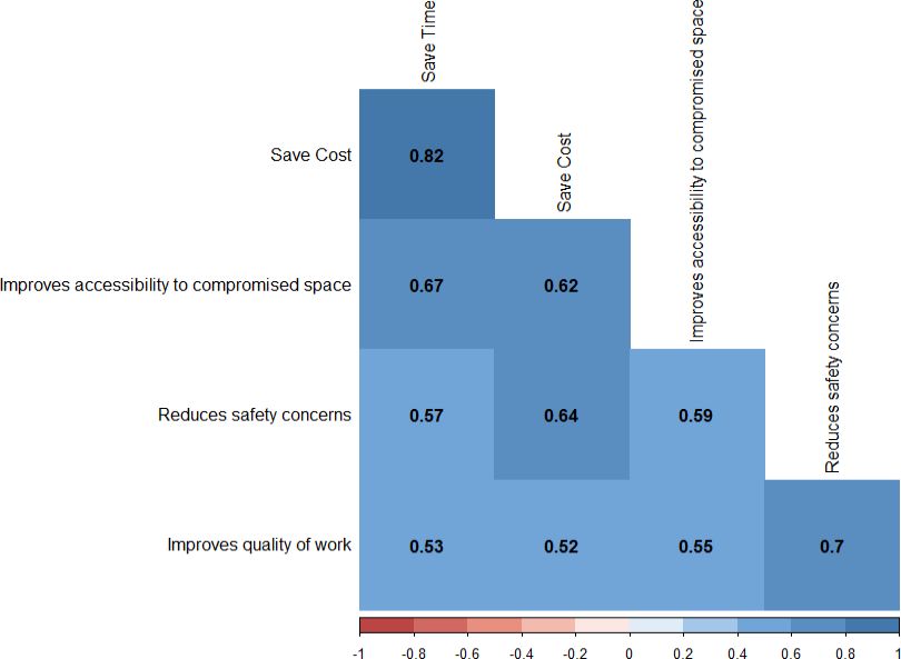
platforms and onboard sensors, respectively. Saving time, improving accessibility to compromised spaces, and
reducing cost while accomplishing construction tasks were highly regarded as UAS implementation benefits in
construction. Participants also considered flying in various weather conditions, within confined or congested
areas, as well as the advanced technical know-how requirements, and the increased liability and legal challenges
as barriers to using UASs in construction-related tasks. By understanding UAS adoption in construction, this study
provides a roadmap to better identify the industry needs and guide researchers and professionals in investigating
application areas and barriers that might have maximum benefits for the construction industry in the United States.
KEYWORDS: UAS, Unmanned Aerial Systems, Construction, Applications, Trends, Technologies, UAV, Drone
REFERENCE: Gilles Albeaino, Masoud Gheisari (2021). Trends, benefits, and barriers of unmanned aerial
systems in the construction industry: a survey study in the United States. Journal of Information Technology in
Construction (ITcon), Vol. 26, pg. 84-111, DOI: 10.36680/j.itcon.2021.006
COPYRIGHT: © 2021 The author(s). This is an open access article distributed under the terms of the Creative
Commons Attribution 4.0 International (https://creativecommons.org/licenses/by/4.0/), which permits
unrestricted use, distribution, and reproduction in any medium, provided the original work is properly cited.
ITcon Vol. 26 (2021), Albeaino & Gheisari, pg. 841. INTRODUCTION
Unmanned Aerial Systems (UASs), also known as drones or UAVs, are remotely piloted aerial platforms equipped
with several onboard sensors (Hassanalian and Abdelkefi 2017). Initially employed for military purposes, these
devices have recently witnessed remarkable technical improvements in terms of software and hardware
components, and in response, their civilian applications have significantly increased over the last few years. Some
examples of such applications are in infrastructure management (e.g., infrastructure inspection, building
inspection), traffic surveillance, agriculture (e.g., crop health monitoring and assessment, soil analyses), material
transport (e.g., delivery of food, medical supplies, parcels), search and rescue operations, as well as security
surveillance (Shakhatreh et al. 2019). In the United States, it is anticipated that the UAS commercial market will
have a yearly impact of more than $30 billion by 2026 (McKinsey&Company 2017).
AEC (Architecture, Engineering, and Construction) industry has also incrementally adopted UAS technology
(Albeaino et al. 2019). UASs have been used in a variety of AEC applications from traffic surveillance
(Barmpounakis and Geroliminis 2020; Hart and Gharaibeh 2011) and landslide monitoring (Niethammer et al.
2012; Yeh and Chuang 2020), to cultural heritage conservation (Enríquez et al. 2020; Koutsoudis et al. 2014;
Uysal et al. 2013) and city planning (Banaszek et al. 2017; Bulatov et al. 2011). Construction, in particular,
witnessed an exponential growth in UAS applications, the implementation of which stems from the benefits
associated with their capability to access unreachable or unsafe areas, and their ability to perform tasks safely and
time-efficiently (Gheisari and Esmaeili 2019; Zhou and Gheisari 2018). In addition, UASs’ recent developments
in terms of regulation updates, low acquisition costs, enhanced navigation features, autonomous flight capabilities,
increased battery life, and variety types of onboard sensors, have played a significant role in their popularity and
wide deployment in the construction industry (Hassanalian and Abdelkefi 2017; Zhou and Gheisari 2018). UASs
can be adopted through different phases of a construction project from site surveying and mapping (Martinez et
al. 2021a; Neitzel and Klonowski 2012) and progress monitoring (Álvares and Costa 2019; Unger et al. 2014) to
building inspection (Eiris et al. 2020; González-deSantos et al. 2020; Hallermann et al. 2015a; Hallermann et al.
2015b), and structures maintenance (Mutis and Romero 2019). A significant amount of research has been done
about how UAS technology can be used for specific construction-related tasks; however, understanding how the
construction industry is incorporating such technology in their day-to-day practices is yet to be investigated.
Currently available survey questionnaires evaluating the practical use of UAS technology in construction based
on the industry professionals’ perspectives are very scarce. Kim et al. (2016) developed a questionnaire to
understand the construction professionals’ viewpoint regarding several UAS-related factors that would affect this
technology’s performance in safety management tasks. The study also highlighted some of the benefits and barriers
to UAS integration in safety control tasks and ranked them in terms of importance based on participants’ responses.
Other more recent questionnaires with a higher population sample focused on the current and future potential use
of UASs in construction, as well as the risks encountered and benefits associated with this technology’s
deployment in this domain (Hubbard and Hubbard 2017; Tatum and Liu 2017). Lately, Gheisari and Esmaeili
(2019) targeted construction safety managers to evaluate the UAS technology’s potential in improving safety
applications and recommended the ideal UAS technical features as well as the enablers and barriers to using UASs
in this setting. However, two of these studies focused only on using UASs in the aspect of construction safety
management (Gheisari and Esmaeili 2019; Kim et al. 2016), and none had targeted a specific population of
construction professionals who had previously used UASs on the jobsites. This is particularly important, as getting
insights from such targeted population would accurately reflect the current state of UAS technology based on
people who have actually used this technology together with its technical components and configurations on their
construction jobsites, and noticed the benefits associated and barriers encountered with its implementation. In
addition, none of these studies had fully identified: (1) current trends in real-world UAS applications throughout
the entire construction lifecycle; (2) commonly used technologies by industry practitioners (i.e., UAS vehicle
types, incorporated software tools, flight autonomy features, mounted sensors, and types of retrieved data); and
(3) current flight training, insurance status, and UAS flight team composition.
The following study bridges the gap between the theoretical and practical implementation of UASs in construction
across the United States. It provides a timely extension to previous conceptual-based efforts (Albeaino et al. 2019;
Golizadeh et al. 2019a; Golizadeh et al. 2019b; Zhou and Gheisari 2018) by presenting, through empirical
observations, how UASs are being employed by construction professionals who had previously used this
technology on their jobsites. The study investigates the UAS implementation status in the construction industry
ITcon Vol. 26 (2021), Albeaino & Gheisari, pg. 85by identifying their real-world application trends, technologies, benefits, and barriers commonly encountered by
industry practitioners and highlights this technology’s adoption in current practices. It also explores current flight
training, insurance status, and flight team composition associated with the UAS deployment in construction. More
specifically, this study addresses the following research questions: (1) What are the current application trends of
UASs in the construction industry? (2) What are the technology trends of UAS integration in construction? (3)
What are the benefits of UAS integration in construction? and (4) What are the barriers to UAS integration in
construction? The analysis was achieved at first by exhaustively reviewing current literature to identify recent
construction-related UAS application areas and technology use. Then, a comprehensive data collection instrument
was designed and distributed across industry professionals in the United States to collect and analyze trends,
benefits, and barriers to UAS integration in construction. The contribution of this research is to assist academic
and industry experts in better understanding the apparatus and its technicalities, ultimately paving the way for a
more effective UAS integration in the construction domain.
2. BACKGROUND
2.1 UAS Application Areas
UAS integration strongly affected current practices within the construction industry. UASs can be adopted for a
variety of applications throughout different construction phases from pre-construction to construction, and even
post-construction.
2.1.1 Pre-Construction Applications
Site mapping and surveying and site planning are the two common types of pre-construction applications that
might benefit from UASs. Site mapping and surveying consist of collecting spatial and temporal information of
jobsites before excavation. Traditional site surveying techniques rely mostly on terrestrial laser scanners, light
detection and ranging (LiDAR) devices, GPSs, and total stations (Hugenholtz et al. 2015). The enormous
acquisition costs of such devices and the time required for complex site surveying have paved the way to integrate
UAS as an efficient alternative (Hugenholtz et al. 2015). As an example, Neitzel and Klonowski (2012) relied
upon low-cost UASs to map an area composed of a landfill and a parking lot with the aim of performing
comparative analyses between the point clouds generated by several data processing software tools. The authors
advocated the use of UAS technology for site surveying applications and indicated that the average positional and
height error values mainly depend on the topography of the surveyed area. The same area was assessed later by
Siebert and Teizer (2013), who implemented a more accurate approach that resulted in a significant error reduction.
The authors indicated that the error would have been lower should a more advanced UAS with higher quality
camera be used. More recently, Martinez et al. (2021a) conducted comparative analyses between a commercially
available UAS and another dual-frequency GPS platform with post-processing kinematic (PPK) georeferencing
capabilities for site surveying types of applications. After evaluating the effects of different technical
configurations (i.e., dual-frequency GPSs, PPK GPS correction) and flight parameters (i.e., image combinations,
camera angle) on the accuracy and visual quality of the derived point clouds, the authors advocated the usage of
UAS technology for site surveying and proposed a matrix summarizing the levels of point cloud accuracies with
respect to the processing time and adopted technical configurations. UASs have also been used for site planning
purposes that usually require extensive knowledge of on-site conditions, location, and surroundings. Beside
utilizing construction and layout drawings, traditional planning and scheduling techniques often require project
managers to walk the jobsite and collect relevant information (Zhou et al. 2018). With the deployment of UASs,
site planners have become able to collect visual information to assist them plan construction activities and provide
detailed schedule, layout, and logistics-related information, particularly when integrated with augmented reality
(AR) (Wen and Kang 2014). Using UAS visualizations, a very recent analysis reconstructed a petrochemical plant
to improve the hoist layout planning efficiency, ultimately resulting in faster, safer, and more efficient operations
on the jobsites (Jiang et al. 2020a). Based on several layout plans generated using a specific algorithm, the authors
recommended an optimized and weighted site plan to improve hoisting operations’ safety and efficiency.
2.1.2 Construction Applications
UAS employment during construction stage can affect several applications from building inspection and progress
monitoring to material handling and security surveillance. Building inspection is defined as the evaluation of
building condition for structural integrity assessment. UAS deployment offers the advantages of mitigating cost,
ITcon Vol. 26 (2021), Albeaino & Gheisari, pg. 86time, and risk associated with typical inspection tasks (Liu et al. 2016). Traditional access methods for inspection
are numerous, but mostly include elevating platforms and scaffolding (Liu et al. 2016). Their drawbacks
encompass the time required for logistics, the safety hazards associated with elevated and hard-to-reach areas, and
the expensive equipment acquisition, justifying the need for more innovative and affordable alternatives
(Morgenthal and Hallermann 2014; Xu and Turkan 2018). As an example, Eschmann et al. (2012) equipped a
UAS with high-resolution cameras for digital monitoring of buildings and crack detection and were able to
accurately observe and identify damages of a facade to the millimeter range. The accuracy of this technology in
inspecting buildings was also validated by comparing it to other, more conventional methods (Wefelscheid et al.
2011). Morgenthal and Hallermann (2014) used UASs to visualize and assess the condition of a stone-made church
tower and its roof, a joint between a hangar wall and its roof, the core of a wind turbine, and a chimney for damage
identification purposes. Despite being challenged by the environmental conditions, the authors encouraged the use
of the UAS technology, as it allowed for a very close and detailed building damage detection while providing
access to hard-to-reach areas. Using the same UAS-based non-destructive method, Hallermann et al. (2015b)
inspected a cathedral and a tower to evaluate their conditions. Similarly to Morgenthal and Hallermann (2014),
the results of this study showed that the high-quality images, together with the aerial platforms’ capabilities of
flying at a proximity of the buildings allowed for a very detailed building assessment, recommending UAS
technology in this setting. UASs have been also used for structural inspection purposes in indoor environments.
Kang and Cha (2018) utilized an Ultrasonic Beacon System (UBS) to autonomously operate their platforms in
GPS-denied environments and were able to detect and localize indoor concrete damages accurately and precisely.
More recently, González-deSantos et al. (2020) successfully developed and tested a UAS-payload system capable
of operating independently from the platform’s navigation and positioning system to improve current UAS-based
structure inspections in indoor or GPS-deprived locations. Testing their system in both indoor and outdoor
environments, the authors demonstrated the system’s practicability in accomplishing semi-autonomous, stable,
and bounce-free contact inspections.
UAS incorporation can also facilitate progress monitoring, which consists of tracking the progress of construction
projects. Traditional supervision methods include walking and collecting terrestrial or satellite jobsite imagery but
are limited by multiple factors. Some of the latter include the time required for manual jobsite surveillance and the
environmental effects on the quality of the satellite images (Ezequiel et al. 2014; Zhou et al. 2018). UASs are
characterized by enhanced flexibility, high-resolution imagery, and operational proximity, making building
monitoring possible over multiple periods (Unger et al. 2014). For example, UASs were successfully deployed to
monitor the construction progress of roads and bridges in a massive infrastructure development project (Ezequiel
et al. 2014). Unger et al. (2014) relied on UAS-generated orthophotos to monitor small building-zoned areas with
time and were able to accurately identify changes over a period of five months. Compared to traditional
photogrammetry, the authors indicated that the use of UAS technology is an efficient alternative that is capable of
accomplishing progress monitoring tasks in a cost- and time-effective manner. Through an automated
collaborative framework, Park et al. (2018) combined an UAS with a ground robot with the aim of generating
three-dimensional point clouds and visualize the construction jobsites. The results showed that the ground-robot
combination improved the effectiveness of progress monitoring applications by reducing onsite human
intervention, reducing the risks and time associated with traditional progress inspections. A more recent study
integrated performance indicators and visual data technologies such as building information modelling (BIM) and
UAS-derived products to improve current progress monitoring tasks on the construction jobsites (Álvares and
Costa 2019). Despite encountering some limitations, the authors demonstrated the successful implementation of
their proposed method on a real-world construction jobsite and noted that their technique is associated with
enhanced collaboration and decision-making, planning failure detection, and jobsite visualization, ultimately
improving jobsite monitoring tasks.
UAS deployment also has the potential to highly impact construction safety planning and monitoring applications.
A construction environment is conventionally assessed by safety managers who are required to constantly walk
and monitor jobsites to identify and modify unsafe practices. Site complexity and size as well as the limited number
of safety managers and their accessibility to unsafe and hard-to-inspect areas of the site might jeopardize their
overall performance and increase the risk of life-threatening consequences (Martinez et al. 2021b; Zhou et al.
2018). Therefore, UAS technology has the great potential to be used as a safety inspection assistant and provide
frequent and quick inspection of construction sites. As an example, Roberts et al. (2017) utilized UASs equipped
with object detectors to reduce crane-associated safety hazards. Using a dense 3D point cloud generated from
ITcon Vol. 26 (2021), Albeaino & Gheisari, pg. 87UAS-acquired videos, Gheisari et al. (2018) proposed an automatic fall hazard identification model that allows
the detection of openings and guardrails not conforming to the Occupational Safety and Health Administration
(OSHA) safety standards. UAS-acquired visuals were also relied upon to identify several on-site components not
meeting safety requirements (de Melo et al. 2017). Using a UAS-generated point cloud, Agung Pratama et al.
(2018) visualized the interior of a typhoon-hit building and incorporated it into a virtual reality (VR) environment
for post-disaster safety training purposes. The study advocated the use of UAS technology in this setting and
concluded that the UAS-acquired visuals allowed for a faster and effortless site reconstruction. Recently, Martinez
et al. (2020) integrated UAS technology in current safety management tasks with the aim of assisting safety
managers in accessing difficult-to-reach and unsafe areas on jobsites. Despite mentioning several limitations that
would hinder this technology’s full deployment for safety applications, the authors emphasized on the UAS
technology’s potential in improving the detection and assessment of outdoor hazardous situations in high-rise
construction projects.
UASs can also be used for construction earthwork operations and volume calculations. Siebert and Teizer (2014)
compared UAS-mediated photogrammetry to conventional tachymetric techniques for earthwork calculations and
advocated the use of UAS technology in this setting. Those results were validated by other researchers, who
monitored the volume change of a gravel stockpile using UAS technology and real-time kinematic GPS surveying
methods (Hugenholtz et al. 2015). Comparative analyses between UAS-based photogrammetry and conventional
GPS-mediated surveying techniques were also conducted on a highway expansion project to evaluate the volume
of earthwork change over time (Wang et al. 2017). Results showed that the average error difference between UAS-
and GPS-based surveying methods were within the acceptable range found in the literature, recommending the
use of UASs due to this technology’s capability of accomplishing tasks effectively and in less time. More recently,
Jiang et al. (2020b) relied on UAS-acquired visuals to perform earthwork volume calculation and monitoring of a
foundation pit and showed that UAS-mediated technique is capable of accomplishing earthwork surveys in a more
efficient and effortless manner compared to conventional methods.
Other construction stage applications in which UAS deployment could be of great potential include aerial
construction, material handling, security surveillance, and site communication. Due to their operational flexibility
and proximity to structures, UASs could be programmed using mathematical algorithms to construct tall and
complex buildings without the need for conventional construction methods such as cranes and scaffolds (Zhou et
al. 2018). Together with aerial construction, UASs could be used as material transportation and handling tool
which, in contrast to conventional transportation equipment, can accomplish tasks more quickly and efficiently
(Zhou et al. 2018). In this context, Lindsey et al. (2011) were able to autonomously control a team of UASs and
perform aerial construction and transportation tasks such as picking up, moving, and assembling structural
elements of a mock-up structure. Another study operated a team of autonomous UASs for collaborative material
transport applications (Mellinger et al. 2010). Michael et al. (2011) also presented a payload transport method that
is based on a swarm of autonomous UASs. The authors showed that the team of UASs is capable of effectively
transporting payloads that could be otherwise difficult to be carried with single UASs. A collaborative work also
explored the possibility of using UASs for the construction of full-scale masonry structures (Goessens et al. 2018).
After designing several construction elements compatible with their customized UAS and testing the platform’s
design and performance by building several types of structures, the authors’ results were encouraging in terms of
potential use of UAS for aerial construction. However, current UAS models are limited in terms of payload weight
and battery life, factors that restrict UASs to carry relatively heavy construction material. In addition, Choi and
Kim (2019) recently relied on UAS technology as a new lifting and transportation means to improve current
modular construction logistics and material handling challenges. Despite encountering several challenges such as
the platform’s instability, limited payload weight, and battery life, the tested platform-module system seemed
promising in terms of construction project time and cost reduction. Security surveillance is another construction
task that could be accomplished using UASs for stealing and trespassing protection on the jobsites (Zhou et al.
2018). Traditional site surveillance methods involve surveillance cameras and patrols that continuously monitor
jobsites. Equipped with regular and thermal cameras, UASs are capable of reducing the need for security patrols,
ensuring the secure storage of construction equipment, and detecting any potential breach from unauthorized
individuals (Zhou et al. 2018). In this context, Bürkle et al. (2011) developed a team of autonomously operated
UASs and simulated an intrusion scenario to test the system’s effectiveness for security surveillance type of tasks.
After presenting several scenarios that justify the need for a swarm of UASs, the study highlighted the importance
of such swarms in monitoring and following intruders in case of any potential violation in the areas of interest.
ITcon Vol. 26 (2021), Albeaino & Gheisari, pg. 88Bhandari and Park (2020) developed a security monitoring system that combines UASs, computer vision, and
deep learning for intruder detection and surveillance in restricted areas. Despite not testing their proposed method
in a construction jobsite intrusion scenario, the authors showed that the system is capable of precisely identifying
intruders and notifying site managers in real-time via cloud-based message service, factors that ultimately improve
the detection and response efficacy associated with any intrusion threats. UASs could also be equipped with
onboard transmitters for site communication purposes. Not only would this task enhance project performance in
general, but it offers managers the ability to communicate in real-time with construction workers and prevent, for
example, safety accidents on jobsites (Irizarry et al. 2012). As an application example, Schneegass et al. (2014)
equipped an UAS with a remotely controlled iPad to explore the concept and potential benefit of mid-air displays
and presented several scenarios to which such configuration could be of significant value. A more recent study
built on the results of previous research exploring mid-air display systems (Scheible and Funk 2016; Schneegass
et al. 2014) by designing a programming toolkit that developers could utilize to create multimedia applications
specifically intended for such type of systems (Lingamaneni et al. 2017). The authors successfully demonstrated
the practicability of their proposed toolkit by developing an application allowing mid-air displays to communicate
and display specific media content to viewers based on the platforms’ location. With such system on construction
jobsites, professionals would ideally be able to communicate and share information with workers from farther
distances, in a more efficient, simultaneous, and prompt manner.
2.1.3 Post-Construction Applications
Post-disaster assessment and building maintenance are the two common types of post-construction stage
applications that might benefit from UASs. Post-disaster assessment involves the evaluation of damage endured
in buildings following natural events. In such extreme cases, it would be difficult and dangerous for inspectors to
assess buildings’ conditions. While other traditional techniques such as satellite imagery are somewhat effective
in covering large areas, their spatial resolution limits their employment on individual buildings or smaller-scale
areas (Adams et al. 2014). For example, Kruijff et al. (2012) combined aerial and ground robots to safely assess
the damage that several structures suffered during an earthquake in Italy. The combination of aerial-ground robots
was also deployed by Michael et al. (2012) to survey the indoor of an earthquake-hit building in Japan. Despite
mentioning several factors encountered during their field experiment (e.g., restricted UAS accessibility to some
areas in the damaged building, UAS operation in GPS-denied environments, UAS robustness and performance in
post-disastrous and dusty environments), the authors were able to provide two- and three-dimensional maps of the
surveyed area and identified several damaged features in this setting. UAS imagery also provided detailed
information about damaged structures, their structural material and components, as well as their failure mechanism
(Adams et al. 2014). Recently, Zhang et al. (2020) proposed a four-step automatic building damage identification
and information extraction technique using UAS-acquired oblique thermal images. After testing their system on
earthquake-affected buildings, the authors advocated the usage of UASs for post-disaster assessment and showed
that their method provided a damage detection accuracy of around 80%. Building maintenance applications include
activities related to the operation and maintenance of buildings such as roof or facade inspection which usually
happen during the post-construction stage of projects. Facility managers maintaining the functionalities of
buildings mainly deal with accessibility challenges to unsafe or hard-to-inspect areas. In addition, the time and
cost associated with typical inspection tasks are high and should be carefully considered. UAS technology could
possibly be deployed as an efficient tool for building maintenance due to the platform’s operational flexibility,
reducing safety hazards and time associated with conventional assessment methods. As an example, Liu et al.
(2016) conducted comparative analyses between UAS- and LiDAR-generated point clouds of a building curtain
wall with the aim of assessing its current condition and concluded that UAS technology is capable of
accomplishing such type of tasks safely and cost-efficiently. Chen et al. (2021) proposed a two-step Geographical
Information System-based method to automate management and documentation of UAS-acquired data for building
facade damage inspection and maintenance applications. Through their building case study, they showed that their
proposed technique was practical and capable of geo-registering UAS images effectively, factors that ultimately
assist construction personnel in the decision-making process of future building maintenance and retrofitting tasks.
Other UAS-mediated building maintenance application examples include: (1) conducting energy analyses by
surveying building facades using a Microsoft® Kinect sensor mounted on the aerial platform (Roca et al. 2013);
and (2) assessing the thermal performance of building envelopes using infrared thermography to detect and
evaluate thermal bridges within facades (Mutis and Romero 2019). Table 1 highlights the results obtained from
the literature review.
ITcon Vol. 26 (2021), Albeaino & Gheisari, pg. 89TABLE 1: Potential UAS application areas
Application Area Description of Application Area Citations
Site Mapping and Collecting information of the construction sites prior to Martinez et al. (2021a); Neitzel and Klonowski
Surveying excavations. (2012); Siebert and Teizer (2013)
Site Planning Planning site activities with detailed schedule, layout, and Jiang et al. (2020a); Wen and Kang (2014)
logistics.
Building Inspection Evaluating buildings’ structural integrity and damage. Eiris et al. (2020); Eschmann et al. (2012);
González-deSantos et al. (2020); Hallermann et al.
(2015a); Hallermann et al. (2015b); Hallermann
and Morgenthal (2013); Kang and Cha (2018);
Morgenthal and Hallermann (2014); Wefelscheid
et al. (2011)
Progress Monitoring Monitoring construction activities on jobsites. Álvares and Costa (2019); Ezequiel et al. (2014);
Irizarry and Costa (2016); Park et al. (2018);
Unger et al. (2014)
Safety Management Protecting construction workers against safety hazards. Agung Pratama et al. (2018); Gheisari et al.
(2018); Martinez et al. (2020); de Melo et al.
(2017); Roberts et al. (2017) ; Martinez et al.
(2021b)
Earthmoving Assisting in excavation and earthwork volume Hugenholtz et al. (2015); Jiang et al. (2020b); Kim
calculations. et al. (2015); Siebert and Teizer (2013); Siebert
and Teizer (2014); Wang et al. (2017)
Aerial Construction Aerially constructing buildings. Goessens et al. (2018); Lindsey et al. (2011)
Material Handling Transporting construction material and tools. Choi and Kim (2019); Goessens et al. (2018);
Lindsey et al. (2011); Mellinger et al. (2010);
Michael et al. (2011)
Security Surveillance Protecting against theft and trespassing on construction Bhandari and Park (2020); Bürkle et al. (2011)
sites.
Site Communication Interacting with workers using onboard transmitters. Lingamaneni et al. (2017); Scheible and Funk
(2016); Schneegass et al. (2014)
Post-disaster Inspecting, communicating, or transporting materials on Adams et al. (2014); Kruijff et al. (2012); Michael
Reconnaissance damaged construction sites. et al. (2012); Zhang et al. (2020)
Building Maintenance Maintaining functionalities of buildings during their life Chen et al. (2021); Liu et al. (2016); Mutis and
span. Romero (2019); Roca et al. (2013)
2.2 UAS Technology
Accomplishing flight missions for construction application depends on several technical aspects of UASs that need
to be considered: (1) selecting an appropriate aerial platform type, (2) choosing the appropriate flying style and
incorporating proper UAS software tools for navigation and data processing purposes, and (3) selecting the
appropriate data collection sensors for specific applications. As a result, understanding the implications of UAS
configurations and technical components on the flight mission is of great importance for the successful integration
of UASs in the construction domain. Two types of UAS vehicles have commonly been used in the construction
domain: rotary-wing and fixed-wing. Rotary-wing vehicles are characterized by their abilities to hover, vertically
takeoff and land, and are known for their flexibility and safe deployment due to their engines’ redundancy
(Ellenberg et al. 2014). Rotary-wing UASs can be helicopters or multi-copters, depending on the number of the
propellers outfitted on the platform. Rotary-wing characteristics make them a potentially better platform for small-
to-medium size projects or vertical types of construction. Fixed-wing vehicles are remotely piloted aircrafts known
by their long flight endurance and abilities to survey large areas (Albeaino et al. 2019). Such capabilities make
them a better platform for large size projects or horizontal construction. Fixed-wing’s main limitations are
hovering incapability and the need for runways to takeoff and land (Zhou and Gheisari 2018). Table 2 describes
the types of UAS vehicles utilized in construction along with some application examples.
ITcon Vol. 26 (2021), Albeaino & Gheisari, pg. 90TABLE 2: Common UAS vehicle types
Vehicle Types Characteristics Related Applications (Citations)
Structural Inspection: (Hallermann et al. 2015a;
Hallermann et al. 2015b)
- Composed of one or multiple propellers. Earthwork Calculations: (Hugenholtz et al. 2015;
- Do not require runways, as they can takeoff and land Jiang et al. 2020b; Siebert and Teizer 2014)
vertically.
Progress Monitoring: (Álvares and Costa 2019;
Rotary-wing - High hovering capabilities.
Unger et al. 2014)
- Considered safe and stable due to propellers
redundancy. Post-Disaster: (Adams et al. 2014; Zhang et al.
- Low flying endurance. 2020)
Building Maintenance: (Kim et al. 2019; Roca et al.
2013)
- Look similar to traditional aircrafts.
- Require runways for takeoff/landing. Post-Disaster: (Ezequiel et al. 2014)
Fixed-wing - No hovering capabilities. Progress Monitoring: (Ezequiel et al. 2014)
- Popular for their ability to survey large areas.
- High flight endurance.
UASs rely mostly on the incorporated software tools while accomplishing their intended tasks. These tools are
used primarily for controlling the UAS vehicles, collaborating with UAS team members, processing images, and
generating 3D models. UAS navigation styles consist of three distinct types: autonomous, semi-autonomous, and
manual. Autonomous flight control relies entirely on autonomous features such as auto-return home, auto
takeoff/landing, waypoint navigation, follow target, obstacle avoidance, and guarded motion. The Auto-return
home is a feature that guarantees the safe return and landing of UASs to their home point (Siebert and Teizer
2014). This function is either automatically activated in case of signal loss and battery depletion, or manually
triggered by the pilot. The automatic takeoff/landing function assists pilots in performing a safe UAS takeoff and
landing (Michael et al. 2012). Waypoint navigation, in which UAS flight routes can be planned using defined GPS
waypoints, is another autonomous UAS feature adopted in construction (Siebert and Teizer 2014). The follow
target function assists operators in programming UASs to constantly follow and depict targeted objects. For
example, the use of this feature could enhance safety managers’ performance in terms of jobsite monitoring by
providing real-time monitoring of targeted objects such as workers and machinery on site. Obstacle avoidance is
another feature that depends on the incorporated sensors within the UAS. The usage of this function, especially in
complex or indoor environments, is extremely efficient as it helps in detecting nearby obstacles and preventing
UAS accidents (Duque et al. 2018). Autonomous UASs are also integrating the guarded motion, which is an
intelligent safety feature that relies on the geofencing technique. This technique gives pilots the ability to create
virtual navigational barriers and automatically control UASs within the defined boundaries. Besides autonomous
control, semi-autonomous navigation combines pilot’s decisions with autonomous features to accomplish flight
missions, whereas manual navigation depends entirely on the pilot’s focus and judgment. It should be noted that
manual navigation does not involve any autonomous capabilities, factor that makes UAS operation and control
more complicated and exhausting (Püschel et al. 2008). Table 3 describes the adopted UAS flying styles and
examples of their application areas in the construction industry.
TABLE 3: UAS flying styles adopted in the construction domain
Flying Styles Description Related Applications (Citations)
- Accomplished using predefined GPS waypoints or
through the integration of GPS with flight planning Structural Inspection: (Kang and Cha 2018)
software. Earthwork Calculations: (Hugenholtz et al. 2015)
Autonomous
- Least intensive operation style for pilots. Post-Disaster: (Ezequiel et al. 2014)
- Fully operated using computers and autonomous Progress Monitoring: (Ezequiel et al. 2014)
features.
Structural Inspection: (Hallermann and Morgenthal
Semi- - Controlled using a combination of autonomous features 2013)
Autonomous and manual (pilot) navigation.
Post-Disaster: (Michael et al. 2012)
- Most intensive operation style for pilots. Structural Inspection: (Eschmann et al. 2012)
Manual - Fully operated through pilots.
- No computer or autonomous intervention. Post-Disaster: (Adams et al. 2014)
ITcon Vol. 26 (2021), Albeaino & Gheisari, pg. 91Various types of sensors can be mounted on the UAS platform depending on the required type of data (e.g., image,
video, audio) and specific application. Payload types range from readily available visual cameras, thermal cameras,
or laser scanners and LiDARs to RFID (Radio Frequency Identification) readers or humidity, and temperature
sensors. For example, thermal cameras were used to assess the thermal performance of structures (Mutis and
Romero 2019) and maintain airports (Kim et al. 2019) whereas laser scanners and LiDARs were deployed for
post-disaster building damage assessment (Michael et al. 2012), and the development of a beyond visual range
guidance system for infrastructures inspection (Merz and Kendoul 2011), respectively. UBSs were deployed as an
efficient GPS replacement for indoor structural inspections (Kang and Cha 2018) and RFID devices were relied
upon to track materials on construction jobsites (Hubbard et al. 2015). Other types of utilized sensors include
motion detectors, air quality devices, and audio sensors such as microphones. As an example, the Microsoft®
Kinect is an RGB-D motion capture device equipped with color and depth cameras, a motorized pivot, and a multi-
array microphone. The Kinect sensor could be mounted on UASs for the real-time acquisition of spatial data, 3D
scanning and modeling, as well as motion detection and monitoring purposes. Table 4 shows the utilized onboard
sensors and some of their application areas in construction.
TABLE 4: UAS onboard sensors used in construction
Onboard Sensors Description Related Applications (Citations)
Structural Inspection: (Hallermann and Morgenthal
2013)
Visual Cameras - Used to collect regular images and videos. Post-Disaster: (Adams et al. 2014)
Building Maintenance: (Kim et al. 2019; Liu et al.
2016)
- Thermographic cameras that sense infrared Post-Disaster: (Zhang et al. 2020)
radiation.
Thermal Cameras Building Maintenance: (Kim et al. 2019; Mutis and
- Collect radiation with longer wavelengths than
visible light. Romero 2019)
- Capture surface shapes of objects or buildings Post-Disaster: (Kruijff et al. 2012; Michael et al.
LiDARs and Laser by using a line of laser beams. 2012)
Scanners - Used to generate digital 3D representations of
objects. Building Maintenance: (Roca et al. 2013)
- An automatic identification and data capture
Radio Frequency sensor.
Progress Monitoring: (Hubbard et al. 2015)
Identification Readers - Used to identify, track, and collect information
pertaining to objects
2.3 UAS Regulations and Training Requirements
The United States Federal Aviation Administration (FAA) institutes rules and regulations about using UASs within
the national airspace system. To be able to use UASs for the commercial application in the United States, the
operator has to be a certified remote pilot, at least 16 years of age and must register the aerial platform through
FAA before conducting any flights (US Department of Transportation 2016). The FAA requires UASs to operate
only over unpopulated areas, within the pilot’s line of sight, and during daylight time (Kim and Irizarry 2019).
The aerial platforms should not exceed 55 pounds (including payloads), fly over 400 feet above ground level or
top of a structure, and faster than 100 miles per hour (US Department of Transportation 2016). However, waivers
could be obtained for some specific restrictions, guaranteeing that the deployment can be accomplished safely
(Herrmann 2018). Future regulation updates are expected to further alleviate UAS operational and flight
restrictions in an attempt to enhance UAS integration in commercial applications. Current FAA regulations,
however, do not require any prior practical knowledge or hands-on experience related to UAS flight and operation.
Several studies have been conducted to develop UAS training tools or modules which incorporate both theoretical
and practical knowledge of UAS flight operations (Eiris Pereira et al. 2018; Williamson III and Gage 2019). As
an example, Eiris Pereira et al. (2018) created hands-on flight and data processing activities for construction
students on UAS technology, its software and hardware components, and its integration with 3D modeling
techniques such as BIM. UAS manufacturers such as DJI®, 3DR®, and Yuneec® are also providing professional
pilot training software and virtual flight simulators for training purposes. Such hands-on training could help users
operate UASs safely and improve their successful implementation in the construction domain.
ITcon Vol. 26 (2021), Albeaino & Gheisari, pg. 923. RESEARCH METHODS
Three main tasks were performed to accomplish the objectives of this study. These included: (1) development of
a survey instrument, (2) data distribution and collection, and (3) data screening and analysis. The following
sections describe these tasks in detail.
3.1 Survey Instrument
The theoretical knowledge acquired from the literature review guided the authors in designing a questionnaire
serving as a data collection instrument. Before its administration, the survey was carefully reviewed and pilot-
conducted among industry experts and selected professors within the M.E. Rinker, Sr. School of Construction
Management at the University of Florida for relevancy and validity assessment.
The survey consisted of five sections, covering the aims of the study. The first section presented a brief introduction
about the study and included the confidentiality policies as well as a consent form that needs to be approved by
each participant. The second section contained questions related to the types of construction applications in which
the respondents have incorporated UASs previously, with respect to the various stages of a project (pre-
construction, construction, and post-construction). If they have applied UASs in construction and indicated as
such, they would then be asked to rate the effectiveness and the frequency of the specific application(s). The third
section contained questions pertaining to the technical features of the UASs, including the UAS platforms’ types
(e.g., rotary-wing, fixed-wing), manufacturers, models, types of data collected (e.g., image, video, audio), software
tools incorporated, onboard sensors, autonomous features, and the level of human involvement. This section also
asked about UAS training, FAA certification, and UAS insurance. Section four included questions related to the
enablers and barriers to using UASs in construction. The fifth section contained questions focusing on the
respondents’ professional background, such as organizational role, years of experience in the industry, career
positions, and construction licenses. Participants were also asked to identify their construction sectors, which
involved buildings, infrastructure, light industry, and heavy industry.
3.2 Data Collection Process
The targeted population consisted of construction professionals who used UASs to accomplish construction-
related applications across the United States. Due to this very narrowed-down target population and the various
groups of construction professionals who might use this technology, identifying and contacting appropriate
participants in the survey was challenging, and no specific directory, group, or email-list was available for such
retrieval. Due to the hard-to-reach audience of this study, participants’ recruitment was accomplished using the
snowball sampling method. The search strategy of the snowball sampling consists of two steps: (1) identifying
potential individuals in the targeted population who are interested in filling out the questionnaire; and (2) relying
on those individuals’ social networks to distribute the survey link and recruit other interested professionals (Sadler
et al. 2010). This chain-referral sampling method constitutes a recruitment mechanism that allows targeting hard-
to-reach audience and keeps on reiterating until the required sample size is met (Valerio et al. 2016). In order to
optimize the response rate as well as simplify respondents’ data submission and collection, the questionnaire was
designed online using the Qualtrics Survey Software (Qualtrics 2019). Qualtrics is a web-based tool that allows
users to design and administer questionnaires, as well as collecting and analyzing their data (Yuan et al. 2014).
The study was first approved by the University of Florida Institutional Review Board (UFIRB #201801233), and
then e-mails and LinkedIn messages were used to invite the construction professionals.
3.3 Data Screening and Analysis
A total of 98 responses were collected and then screened to exclude incomplete responses. After screening, 56
complete responses were eligible for inclusion in the study and further analysis using descriptive statistics was
conducted on them. Participants were distributed across 22 states in the United States and Washington D.C., as
shown in Table 5. Participants also rated that they had a high level of familiarity with UASs (Average: 4.04,
1=Very Low and 5= Very High) and around 75% of them had more than 5 years of construction industry
experience.
In terms of licenses and certifications, respondents were professional engineers (PEs) (7%), certified general
contractors (CGCs) (5%), licensed architects (4%), associate constructors (4%), and designated design-build
professionals (4%). The remaining included Professional Surveyors and Mappers, Leadership in Energy and
Environmental Design (LEED) Accredited Professionals, Construction Health and Safety Technicians, and Safety
ITcon Vol. 26 (2021), Albeaino & Gheisari, pg. 93Trained Supervisors, among others. Most of the respondents occupied construction manager and/or general
contractor roles (77%), followed by engineers (13%), consultants (11%), owners (7%), and specialty/trade
contractors (7%). Other roles included architects or designers, innovation specialists and project coordinators. In
terms of specific career position, most of the respondents were project managers or assistant project managers
(57%) followed by project engineers (32%), VDC (virtual design and construction) team members (25%), and
superintendents (11%). Others included laborers, project executives, consultants, foremen, architects, safety and
health managers, surveyors, quality directors, operations managers, and vice-presidents. It should be noted that
since some participants had various organizational roles or positions in different projects, the total percentage is
greater than 100%. In terms of the construction sector, the largest sector was buildings (88%) (including
communication centers, lodging facilities, offices, medical centers, scientific and technological buildings,
maintenance facilities, car park facilities, recreational centers and gymnasiums, dining establishments/bars/night
clubs, retail buildings, educational, storage and distribution spaces, single family detached, single family attached,
large multi-family, detention centers, and special-purpose facilities), followed by infrastructure (38%) (including
transport facilities, dams, levees, floodways, channels, roads, bridges, marine facilities, navigation, mass transport
systems, tunnels, public utilities such as electric, telecommunications, water, wastewater, garbage, gas and sewer
distributions and networks), light industry (27%) (including food, automotive, electronics, electrical equipment,
consumer products, and pharmaceutical/drug manufacturing), and heavy industry (18%) (including metals,
petroleum, oil, and gas refining and processing, process chemical, mining, power generation plants and stations,
oil exploration, as well as pulp and paper manufacturing).
TABLE 5: Respondent Demographics
Parameter Number Percentage of Total
Experience
Less than 5 years 14 25%
5 to 10 years 12 21%
11 to 20 years 20 36%
21 to 30 years 6 11%
Over 30 years 4 7%
Licenses and Certifications
Professional Engineers 4 7%
Certified General Contractors 3 5%
Licensed Architects 2 4%
Associate Constructors 2 4%
Designated Design-Build Professionals 2 4%
Other 9 16%
Organizational Roles
Construction Managers/General Contractors 43 77%
Engineers 7 13%
Consultants 6 11%
Owners 4 7%
Specialty/Trade contractors 4 7%
Other 4 7%
Career Positions
Project Managers 22 39%
Project Engineers 18 32%
VDC Team Members 14 25%
Assistant Project Managers 10 18%
Superintendents 6 11%
Other 34 61%
Construction Sectors
Building 49 88%
Infrastructure 21 38%
Light Industry 15 27%
Heavy Industry 10 18%
ITcon Vol. 26 (2021), Albeaino & Gheisari, pg. 944. RESULTS
4.1 Application Trends of UAS Integration in Construction
This section aims to identify UAS application trends within the construction industry. In this context, practitioners
were asked about the tasks in which they or their organizations have implemented UAS technologies (See Table
6). The analysis revealed that the most common UAS application was progress monitoring (84%). UASs are
capable of fully automating the visual site documentation process by providing a bird’s eye view on construction
jobsites while capturing high-quality visual contents of construction activities more frequently and at a remarkably
low cost and time. Such characteristics would make UASs a popular platform for progress monitoring. Site
planning (68%) and site mapping and surveying (61%) were the other popular UAS application areas in
construction. In such applications, UAS would assist construction personnel in obtaining spatiotemporal
information of the jobsite and help them better plan construction-related activities, schedules, and logistics. The
least common application areas were aerial construction (14%), security surveillance (9%), material handling
(7%), and site communication (7%). Technical limitations such as payload weight, battery life, and onboard
sensors restrict UASs to carry heavy materials or equipment for aerial construction, transportation, and
communication applications. It is also worth noting that FAA rules prohibit UAS operations during nighttime and
out of visual line-of-sight which might currently limit its deployment as a security surveillance tool on construction
jobsites. However, given the rate of technological advancements and regulation updates, it is more likely that these
types of applications overcome the presented limitations and become more frequently implemented in the near
future.
TABLE 6: UAS application areas within different construction phases
# Areas of Application Construction Phases Frequency N (%)
1 Progress Monitoring Construction 47 (84%)
2 Site Planning Pre-Construction 38 (68%)
3 Site Mapping and Surveying Pre-Construction 34 (61%)
4 Earthmoving Construction 28 (50%)
5 Building Inspection Construction 27 (48%)
6 Safety Management Construction 18 (32%)
7 Building Maintenance Post-Construction 11 (20%)
8 Post-disaster Reconnaissance Post-Construction 10 (18%)
9 Aerial Construction Construction 8 (14%)
10 Security Surveillance Construction 5 (9%)
11 Material Handling Construction 4 (7%)
12 Site Communication Construction 4 (7%)
Participants were then asked to rate the effectiveness and frequency of integrating UASs in their different
application tasks. The objective was to better understand UAS adoption in the construction domain, and identify
most frequent, effective, and important application areas in this setting. Participants provided their feedback on
how effectively and frequently they used UASs in each specific application using Likert scales. The mean, average
and standard deviation of the responses are summarized in Table 7. Top application areas that had more than ten
number of responses were used in this analysis. Participants rated site mapping and surveying (average: 4.38 ±
0.73) as the most effective application, followed by progress monitoring (average: 4.34 ± 0.75), and site planning
(average: 4.21 ± 0.73). It is worth noting that the same three applications were also rated as the most common
application areas of UASs (Table 7). The least effective applications were post-disaster reconnaissance (average:
3.70 ± 0.64), safety management (average: 3.61 ± 0.89), and building maintenance (average: 3.36 ± 0.77).
Regarding the frequency of use, the least frequent applications were building maintenance (average: 2.50 ± 0.67)
and post-disaster reconnaissance (average: 2.00 ± 0.77).
To better evaluate the results, an importance factor was introduced, calculated through multiplying effectiveness
and frequency average ratings. This factor allows for assessing the significance of using UASs for various
applications within the construction domain. The most important construction applications that can use UASs are
progress monitoring (17.45), site mapping and surveying (15.98), and site planning (13.85). These findings are
valuable as they provide researchers with a roadmap that illustrates the top UAS application areas in construction
ITcon Vol. 26 (2021), Albeaino & Gheisari, pg. 95You can also read