Tropical like Cyclone "Udine" on 15-20 September 2020
←
→
Page content transcription
If your browser does not render page correctly, please read the page content below
Tropical like Cyclone “Udine” on 15-20 September 2020
                                                 written by
              Fabio Zimbo – Certified Meteorologist WMO compliant n°1083, AMPRO Meteorologist

  Daniele Ingemi – Certified Meteorological Technician WMO compliant n°1083, AMPRO Meteorological Technician

The tropical cyclone called "Udine" (according to the official name of the University of Berlin which
traditionally assigns a name to the European depressive systems) affected the central Mediterranean basin
from September 14 to September 20, 2020, bringing extreme events (such as heavy rains, strong winds and
storm surges) in particular in Calabria (but only in the lower Crotone area and in the Locride area), eastern
Sicily and Greece.

Its origin is explained with the formation of a trough in the perturbed Atlantic flow which on September 6
extended to France, going in "tear off" on September 7, and finally in "cut-off" on the Balearic Islands on
September 8.

                                                                                                   Pag. 1 a 21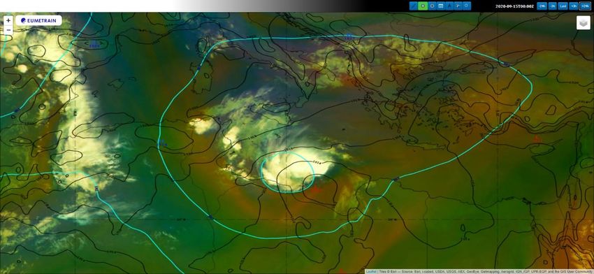
From that moment on, this cold-air drop began a very slow movement towards the west, at times reabsorbed
again in "tear offs" on September 10 by the Atlantic flow

and again in "cut-off" starting from September 11.

In particular, on September 14 the situation at the isobaric surface of 500 mb looked like this:

                                                                                                   Pag. 2 a 21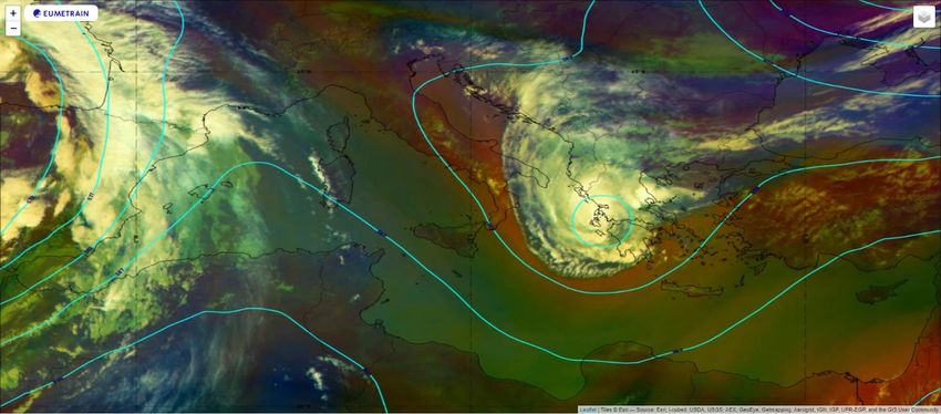
with the minimum of geopotential to the aforesaid isobaric surface, located approximately in front of the
coasts of Tripoli, near the Gulf of Sirte.

At that date, the cold-air drop was stationed on a very warm sea surface: as visible from the map of the sea
surface temperatures detected, at night, by different satellite platforms on the infrared channel and
accessible from the site of the European Copernicus project (https://resources.marine.copernicus.eu/), the
sea surface at 0:00 UTC on September 14, in the area where the geopotential minimum was, had a
temperature of about 28 °C (301 K), warmer than the average of about 1.5 ° C.

                                                                                                 Pag. 3 a 21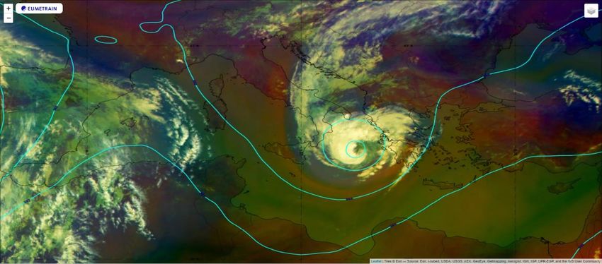
The high vertical thermal gradient present for days in front of the coasts of North Africa favored the
development of intense convective activity since September 12/13, as shown by the following satellite image
(taken from http://eumetrain.org/) of the composite RGB called “airmass” with the image from the infrared
channel 10.8 superimposed on it, “enhanced” with the use of colors (which allows to identify the most
intense storm nuclei with the red color) and the geopotential isolines to the isobaric surface of 500 mb (blue):

As you can see, the convective activity, although evidently present, was still completely disorganized, despite
being fairly intense as shown by the image of September 14:

In fact, since September 13, a low ground pressure of about 1011 mb was formed along the ascending branch
of the trough, which by now had positioned its axis along the parallels:

                                                                                                    Pag. 4 a 21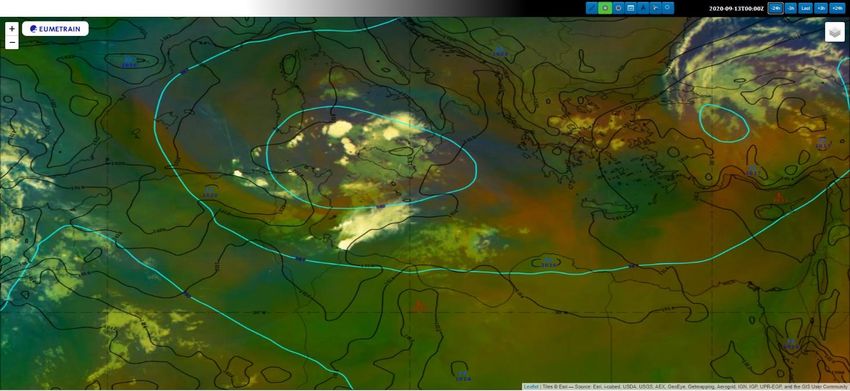
Over the following days, following the dynamics of the minimum at high altitude, this pressure moved
towards north on the Gulf of Sirte:

The formation of this minimum initiated the loop, characterized by "positive feedback", typical of the
formation of tropical cyclones: the minimum intensifies the convergence to the ground which facilitates
upward movements and therefore the release of latent heat which, in turn, warming the heart of the system,
intensifies the aforementioned upward movements and therefore, backwards, the convergence in the lower
layers, deepening the minimum which, in fact, in the following days reached values of about 1007 mb at
00:00 UTC on September 16, 995 mb at the same time on September 17, and about 992 mb at 3:00 UTC on
September 18 at the time of the landfall on the Greek coast:

                                                                                               Pag. 5 a 21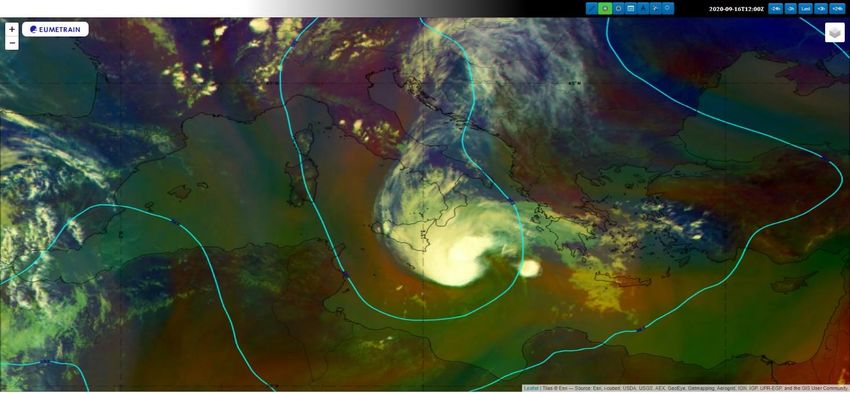
At the same time, starting from September 15, the first sketches of spiraling cloudiness began to be
identified, and they become more and more definite in the following days:

                                                                                          Pag. 6 a 21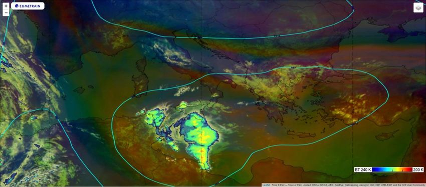
with convective cloud tops reaching up to 209 K (about -64 ° C):

                                                                   Pag. 7 a 21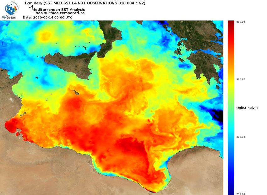
It is precisely in these situations that the system takes on more typically tropical characteristics.

In particular, at the morning of September 17, the minima on the ground and at an altitude of 500 mb aligned
on a sub-vertical line, presenting a closed conformation:

and a weak warm "heart" was presented at 850 mb and 500 mb:

                                                                                                        Pag. 8 a 21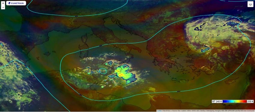
This situation was accentuated at the time of the landfall on September 18:

                                                                              Pag. 9 a 21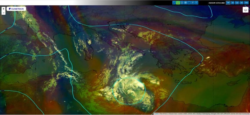
Pag. 10 a 21
The transition phase is also confirmed by Hart's phase diagrams which show how between September 17
and 18 the hot heart became symmetrical (first phase diagram):

while the warm heart tended to deepen more and more (second phase diagram):

                                                                                       Pag. 11 a 21
Shortly, starting approximately from the central hours of September 17, the tropical system "Udine"
assumed purely tropical characteristics: symmetrical structure and a deep warm heart.
Below is the isentropic, divergence and omega (upward motions), along the indicated cross section: in
addition to underlining the very high values of convergence on the ground and divergence in high altitude,
and the consequent intense upward motions, note how at the time of landfall, when "Udine" assumed full
tropical characteristics, there was a non-perfect alignment along the vertical between the divergence core at
altitude (about 275 mb) and the convergence core on the ground:
Pag. 12 a 21It is also interesting to note the high potential vorticity values in the vicinity of the cyclone core, also
remarked by the very low altitude at which the surface 1,5 PV was positioned, i.e. 920 mb: please note (NEC
#013 link → http://www.meteoprofessionisti.it/nec.php by M.M. Miglietta) that the intrusions of dry air from
the lower stratosphere, towards the middle and lower troposphere, are one of the peculiar characteristics
that differentiate TLCs such as "Udine" from “real” tropical cyclones: in fact, "the intrusions of dry air (have)
the effect of inhibiting the further development of convection near the center of the cyclone in the mature
phase, and of producing less intense and lasting vortices than what could happen in the absence of this
process".
Pag. 13 a 21Finally, it should be noted that the most intense convective activity occurred in the early stages of its
development, in particular between September 14 and 16, when at the top of the cumulus clouds,
temperatures of only 207 K were measured on September 14 at 18:00 UTC, 205 K (approximately -68 ° C) on
September 15 at 00:00 UTC, and 206 K on September 16 at 06:00 UTC:
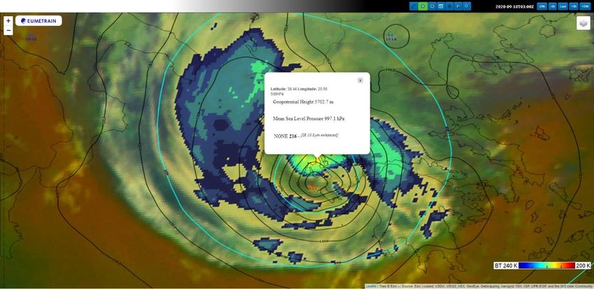
Pag. 14 a 21while in the maturity phases, in particular at the time of landfall (September 18 at 03:00 UTC), the values
measured at the top of the clouds were higher: 216 K (about -57 ° C), a sign of a "weakening " convective
activity, in any case already started from September 17:
This result is in full agreement with another study (above all: Price, C., Asfur, M. & Yair, Y. Maximum
“Hurricane intensity preceded by increase in lightning frequency”. Nature Geosci 2, 329–332 (2009). →
https://doi.org/10.1038/ngeo477) which, analyzing 56 hurricanes worldwide, has shown how the frequency
of lightning strikes (linked to the intensity of convective motions) and the maximum sustained winds are
significantly correlated (with a value of 0.82): in particular, the maximum winds (and therefore the
minimum pressure values) are preceded by an increase in lightning activity about 1 day earlier.
Pag. 15 a 21Dynamic analysis
Among the many elements favorable to its rapid investigation, we find that one in particular is generally
fundamental for the development of a "TLC" (tropical like the cyclone): the passage in the upper
troposphere of a "Jet Streak", a maximum speed of the "jet" that intercepts the depressive circulation, giving
it further positive vorticity. In this case, since the "polar jet", with its main branch, was kept away from the
central Mediterranean, it was the passage of a "drift", a maximum wind speed in the upper troposphere not
associated with the " jet stream ", over Sicily, to give further vorticity to the system, causing a lowering of
the upper limit of the troposphere on the Ionian Sea, with the consequent entry of very cold and dry air, of
stratospheric origin above of the mesoscale depression ("stratospheric invasion"), causing it to degenerate.
The overlap of this cold and very dry flow in the upper troposphere represents in many cases the real trigger
factor of these cyclones, which in the phase of deepening, during the passage over the warm waters of the
Mediterranean, start to absorb a large quantity of latent heat, sucked by the intensification of convective
motions (ascending currents) inside the depressed circulation. In the initial phase, the cyclone had to deal
with a moderate "shear" of the wind, induced by the passage on its southernmost edge of a branch of the
"sub-tropical jet", which cut the convection out of the eye, pushing it towards north-northeast. Going up
north, between September 17 and 18, "Udine" entered an area on the central Ionian, characterized by a
weak "wind shear", which did not affect its development too much.
Intensity of cyclone
Already on September 15, 2020, the cyclone had begun to intensify, during the ascent from the Libyan Sea
towards the Ionian Sea, presenting sustained average winds of 65 km / h and a central pressure that began
to drop below 1010 mb. On September 16, the cyclone had significantly intensified in the lower Ionian Sea,
with the consequent intensification of winds in the area around the central eye. The figure below shows the
winds measured by the ASCAT (scatterometer) satellite, indicating wind speeds in excess of 90 km / h (25 m
/ s) around the cyclone.
Pag. 16 a 21According to the data provided by Ascat, at this stage, the cyclone would be classified as a real tropical storm.
At the beginning of September 17, the cyclone had approached the Italian coast on the Ionian Sea, with the
advancement of extended bands of almost stationary rain that reached the Ionian coasts of Calabria, where
there were very consistent rainfall accumulations at local level (see next paragraph). The last analysis of the
Ascat, carried out on September 18, just before the approach to the Ionian islands (see following figure),
suggests that "Udine" had reached its maximum intensity, becoming a real Mediterranean hurricane, with
sustained average winds, around the central eye, up to 120 km/h (about 65 knots) and a central pressure
estimated around 992 mb. Shortly after its approach on the island of Kefalonia, wind gusts of over 120 km/h
were recorded; they uprooted dozens of trees and seriously damaged the power lines, causing blackouts.
Pag. 17 a 21Effects on the territory
Calabria and Sicily
The tropical cyclone “Udine” has interested Calabria in the day of September 17, bringing rain on almost all
the regional territory (largely spared only the Cosentino area), with more consistent accumulations on the
lower Reggino (the weather station called "Arasì", located within the territory of the municipality of Reggio
Calabria at 645 m above sea level, recorded 53.8 mm), on the Ionian slopes of the Vibonese (the station of
Mongiana recorded 37.8 mm), and in the lower Crotonese (with values of 33 mm at Crotone, 74 mm at
"Salica" also in the municipality of Crotone, and a good 167.4 mm at the station "Campolongo" within the
municipality of Isola Capo Rizzuto at 108 m a.s.l.) (all the stations indicated here are managed by the Multirisk
Functional Center of Arpacal).
The rains on the lower Crotonese area were caused by a long series of thunderstorms with very high ceraunic
activity.
Pag. 18 a 21In particular, as reported in the article https://www.meteoincalabria.com/il-ciclone-tropicale-sfiora-la-
calabria-nubifragio-a-isola-capo-rizzuto/22193/, from 7:15 a.m. to 8:15 a.m. the station of "Campolongo"
recorded an accumulation of 79 mm, as shown in the pluviogram in the figure:
Pag. 19 a 21These storms caused considerable damage. As reported in the Gazzetta del Sud
https://catanzaro.gazzettadelsud.it/foto/cronaca/2020/09/17/maltempo-sulla-costa-ionica-calabrese-106-
interrotta-e-allagamenti-a-isola-capo-rizzuto-21088a2a-0552-4115-a45e-6e8e282781a9/ )
"The strong gusts of sirocco that sweep the coast combined with the violence of the heavy rain that fell caused
the fall of mud on the Ionian State Road 106, interrupted in two points at km 231 and km 232, between
Crotone and Catanzaro at the height of the territory of Isola Capo Rizzuto".
"Floodings also occurred in the inhabited center of Isola Capo Rizzuto. In via Tesoriere the most critical point,
where the Civil Protection teams of the Municipality had to intervene. Flooding also in Crotone with the Fire
Brigade engaged in numerous interventions".
As well as (from “Il Crotonese” https://www.ilcrotonese.it/il-ciclone-tropicale-sfiora-isola-capo-rizzuto-in-
poche-ore-caduti-148-mm-di-pioggia/ ):
"Again in the tourist location (of Le Castella) the rain swelled the stream Acquavrava that flows near the
tourist villages: the water overwhelmed everything".
Other salient data were the storm surges both on the lower Crotonese (see the article in Il Crotonese
https://www.ilcrotonese.it/il-ciclone-tropicale-sfiora-isola-capo-rizzuto-in-poche-ore-caduti-148-mm-di-
pioggia/ ):
"At the port of Le Castella the strong wind and wave motion created caused problems for the boats, some of
which broke their moorings and sank in the port and dock. The intervention of the Naval League, the Blue
Mediterranean Cooperative with the support of volunteers of Isola Ambiente Apnea prevented other boats
from sinking".
and in Locride, as reported in the beautiful photographic report of Lentelocale
(https://www.lentelocale.it/home/maltempo-a-siderno-le-mareggiate-distruggono-i-lidi-del-
lungomareimmagini-e-video/) on the damage caused to the waterfront of Siderno (for the latter, read also
the article: https://www.telemia.it/2020/09/siderno-le-onde-si-abbattono-su-lidi-e-barche-gravi-danni-
paura-per-il-lungomare/ ).
Also in Sicily, the close passage of the cyclone, during its ascent to the north, caused several damages, due
to the heavy rains, but especially for the storms that hit the eastern coasts. During the night between
September 16 and 17, a part of the imposing waves raised by the strong eastern winds, active along the
northern quadrant of the deep cyclone, headed towards the coasts of eastern Sicily, in the form of long or
very long waves (swell), even more than 3 meters high, causing sudden swells between the Ionian coasts of
Messina, Catania, Syracuse and part of the coast of Ragusa. On the coast of Messina, the first big waves
reached the beaches, causing a lot of damage to the bathing establishments still open, and sinking several
boats, especially in the area between Roccalumera and Letojanni, where about ten boats and motorboats,
still attached to the buoys, sank in the sea.
Pag. 20 a 21Greece
Much greater damage was recorded in Greece, where the cyclone stationed for almost 24 hours, with the
eye positioned close to the Ionian Islands. In Kefalonia, dozens of felled trees and widespread blackouts were
reported. During the approach to the Greek coast, the islands of Ithaca, Zakynthos and Kefalonia were
affected by a high wave that flooded the coastal roads and many seaside villages. The greatest damage
occurred on the island of Ithaca, where waves, up to 5 meters high, moved large masses of decomposing
organic matter, which on the coastline produced huge amounts of foam, blown by strong gusts of wind to
the inhabited center. In Kefalonia the torrential rains, which exceeded 200 mm in 24 hours, caused landslides
and the overflowing of small watercourses. More than 5000 houses were damaged, many of which are
located between Zakynthos, Kefalonia and Ithaca. But also dry land was damaged. In all Greece, "Udine"
caused the death of 4 people, while one is missing. On September 19, a man was found dead in his farm at
the north of Athens, while the body of a woman was recovered from his flooded house in a city not far from
the Greek capital. On September 20, the body of a 62-year-old farmer was found under the collapsed roof of
his house in a village at the north of Athens. In addition, a 43-year-old woman was found dead on September
24, after being declared missing on September 20. The woman was washed away several kilometers from
her car, swept away by a river of water and mud. A bridge also collapsed in Karditsa, one of the most affected
areas, while in Thessaly, heavy rains seriously affected crops.
Here are some interesting links about the damage caused in Greece by the passage of the cyclone "Udine":
The "foam" in Ithaca: https://www.facebook.com/924055637648706/videos/3644640105588571
Flood of the Kaletzis River in Karditsa:
https://www.facebook.com/924055637648706/videos/3361073060783760
Kefalonia Island: https://www.facebook.com/SevereWeatherReportsGr/posts/2750808528495660
Assos of Kefalonia: https://www.facebook.com/watch/?v=2945205922390335
Pag. 21 a 21You can also read