Under the Big Sky e-Letter March 2021 - National Weather Service Glasgow, MT Photo Credit: Ryan Bernhart Meteorologist at NWS Glasgow - National ...
←
→
Page content transcription
If your browser does not render page correctly, please read the page content below
Under the Big Sky
       e-Letter
     March 2021

                           Photo Credit: Ryan Bernhart Meteorologist
                           at NWS Glasgow.

National Weather Service
     Glasgow, MT
A Peak Inside: Fort Peck Lake/CANL...Page 1 CoCoRaHS/30 Day Summary...Page 2 Hydro Summary...Page 3 CPC Outlook/Drought Monitor...Page 4 Climate Highlights...Page 5 Monthly COOP Precipitation...Page 6 Monthly Trivia...Page 7
Cold Advisory for Newborn Livestock (CANL)

The calendar says Spring is here, but cold snaps, rain and snow, and gusty winds can all have an impact on new-
born livestock during calving season. As calving continues across NE Montana, know that we are here to help with
the Cold Advisory for Newborn Livestock (CANL). NWS Glasgow uses this criteria based on research and feedback
from the ranching community for the CANL product. Online via our website, you can also find additional back-
ground information on this product. The latest CANL forecasts are updated daily.

                            Figure 1: Here is an example of a CANL forecast valid 6am 3/31 through
                            Noon. Note the higher impacts to the east where cold morning tempera-
                            tures settled in.

                                                             1
30 Day Percent of Normal Precipitation (Montana)
Looking for Weather Observer for CoCoRaHS:
NWS Glasgow is looking for new CoCoRaHS volun-
teers to send in daily precipitation reports.

CoCoRaHS is a grass-
roots organization
with a network of
dedicated observers
who report daily pre-
cipitation such as
rain, hail, or snow                                          Figure 2: 30-day percent of normal precipitation across
from all across the                                          Montana.

country. The data
are used by meteorologists, insurance adjusters, mos-         Avg. Temp Departure from Normal (Montana)
quito control, and even by those in academia.

           ***Training Announcement***
If you’re looking to become a new observer or looking
for some refresher training, we have set one up for
4/21/2021 from 3:30-4PM MDT with emphasis on
warm season observing. Details below:
When: April 21, 2021, 3:30-4:00 PM MDT
GoToMeeting Link:
                                                            Figure 3: 30-day temperature anomalies across Montana.
https://www.gotomeet.me/NWSGlasgow/nws-
glasgow-cocorahs
                                                            Summary: Across much of MT in general, includ-
Dial-in Option:                                             ing NE MT, the last 30 days can be characterized as
United States: +1 (646) 749-3122                            having been markedly drier and warmer than aver-
                                                            age. This has been contributing to growing drought
Access Code: 273-142-405
                                                            concerns across the region. The exception (for
                                                            temperatures) is across southwest parts of the
Participating in the CoCoRaHS program is a great way        state, where things have trended closer to normal
to make a difference in your community. Check out           to a couple degrees below normal.
the CoCoRaHS main page to learn more!

                                                        2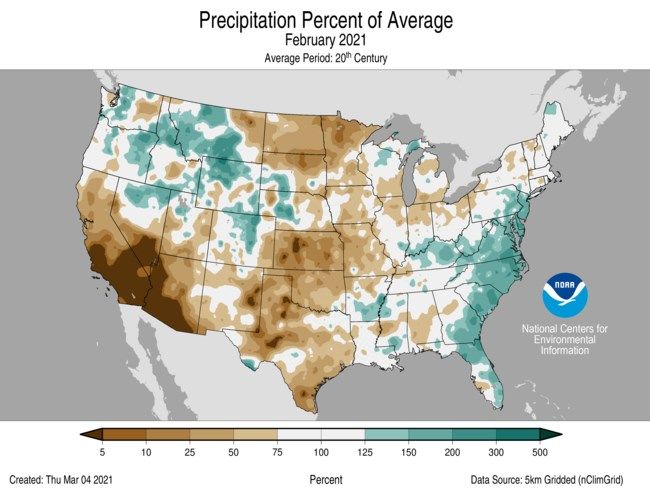
Hydrologic Summary for February 2021 by Greg Forester, Lead Forecaster at NWS Glasgow:

It was a colder than normal month over Northeast Montana. Temperatures averaged be-
tween 6 degrees and 11 degrees below normal across the region. Glasgow averaged 10.8 de-
grees which was 8.5 degrees below normal.

Most locations had below normal precipitation for the month. The dry spots were Scobey
with 0.04 inch, Glasgow 14 NW with 0.05 inch, and St. Marie, Opheim 12SSE, and Wolf Point
with 0.06 inch. The wet spots were Zortman with 0.67 inch, Flatwillow with 0.47 inch, and
Raymond with 0.25 inch. Glasgow received 0.10 inch which was 38 percent of normal.

Stream flow on the Milk, Yellowstone, Missouri, and Poplar Rivers was not available due to
rivers being partly frozen.

The Fort Peck Reservoir elevation fell below to 2233.2 feet during the month. The reservoir
was at 79 percent of capacity and 99 percent of the mean pool.

                                                                  Background Photo Credit: Greg
                                                                  Forrester, Lead Forecaster at
                                                                  NWS Glasgow.

                                              3
CPC Three Month Outlook:                                              U.S. Drought Monitor:
The Climate Prediction Center released an update of                   The latest U.S. Drought Monitor was released on
its three month outlook for temperature and precip-                   Thursday April 1, 2021. Worsening drought continues.
itation for April through June back on March 18,                      Much of NE Montana is now under moderate to se-
2021. The outlook calls for above average tempera-                    vere drought, with eastern Roosevelt and eastern Rich-
tures to be favored for much of the state. Precipita-                 land counties in an extreme drought situation. Check
tion is favored to be below normal, unfortunately,                    out the latest here.
across southern parts of the state. Equal chances for
above normal, below normal, or normal precipita-
tion exist elsewhere but no strong signals exist for
drought relief at this time.
The latest outlook in full detail is always available
here. In addition, you can check out the Climate
Prediction Center Interactive site! You can zoom in
on our area, and navigate to see the climate outlook
for your specific location. The pie charts on the left
hand side can be particularly useful for assessing the
outlook at your specific location.

Figure 4: Climate Prediction Center three month temperature
(top) and precipitation (bottom) outlook for April 2021 through
June 2021.

                                                                          Figure 5: U.S. Drought Monitor updated April 1, 2021

                                                                  4
U.S. & Global Climate Highlights (February): The
U.S. & Global climate highlights for February 2021 have
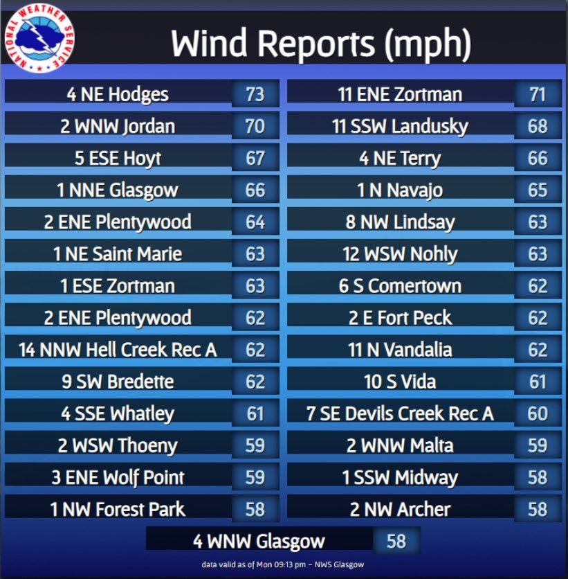
Social Media Highlight of the Month
been released, the latest month for which data was
available. A few points for you to take home are provid- A strong cold front pushed through NE Montana,
ed below. leading to high winds on Monday 3/29/2021. Here
are some of the preliminary reports.
Figure 6: February 2021 Percent of Average Precipitation (U.S.).
U.S. Highlights for February 2021
1) The contiguous U.S. average temperature for Febru-
ary 2021 was 30.6 °F, ranking as the 19th coldest. Figure 7: Social media graphic depicting high wind reports on Mon-
day 3/29 following a cold frontal passage.
2) The average February precipitation total for the con-
tiguous U.S. came in at 1.99 inches. This ranks within
the middle of the existing period of record.
Links You May Like:
Global Highlights for February 2021
ENSO Update
1) The February 2021 global land and ocean surface
Spring Outlook: Drought Expansion
temperature was the 16th warmest February on
record. Winter Outlook: A Look Back
Climate Impact: Antarctic Sea Ice
2) The February 2021 global oceans experienced the
9th warmest February on record.
3) La Niña continued to be present during the month of
February.
5
COOP Precipitation Data (*Preliminary* February 2021)

Station Precipitation    Location                  Station Precipitation     Location
   BAYM8            0.14             Baylor          MDCM8              0.09       Medicine Lake 3 SE
   BRDM8            0.13           Bredette          MLDM8              0.11              Mildred 5 N
   BTNM8              M      Brockton 17 N           MSBM8              0.39             Mosby 4 ENE
   BKNM8            0.13      Brockton 20 S          OPNM8              0.11             Opheim 10 N
   BKYM8            0.05 Brockway 3 WSW              OPMM8              0.06           Opheim 12 SSE
   BRSM8              M            Brusette           PTYM8             0.21              Plentywood
    CLLM8           0.77     Carlyle 13 NW           PTWM8              0.19         Plentywood 1 NE
   CIRM8             0.17             Circle         POGM8              0.07           Port of Morgan
  CHNM8              0.07           Cohagen           RAYM8             0.25 Raymond Border Station
    COM8             0.21     Cohagen 22 SE           SAOM8             0.13              Saco 1 NNW
  CNTM8              0.12      Content 3 SSE          SMIM8             0.06                 St. Marie
  CULM8              0.08         Culbertson          SAVM8               M                     Savage
  DSNM8                M        Dodson 11 N           SCOM8             0.04             Scobey 4 NW
   FLTM8             0.47   Flatwillow 4 ENE          SDYM8             0.11                    Sidney
   FPKM8             0.15       Fort Peck PP           SIDM8            0.04                 Sidney 2S
  GLAM8              0.05    Glasgow 14 NW            TERM8             0.13                     Terry
 GGWM8               0.10      Glasgow WFO            TYNM8               M             Terry 21 NNW
  GGSM8              0.31    Glasgow 46 SW             VIDM8              M                  Vida 6 NE
 GNDM8              0.08     Glendive WTP            WSBM8                M                    Westby
  HRBM8                M               Harb          WTRM8              0.03              Whitewater
  HINM8             0.02     Hinsdale 4 SW            WHIM8               M         Whitewater 18 NE
  HNSM8             0.07    Hinsdale 21 SW           WBXM8              0.11               Wibaux 2 E
 HOMM8              0.07    Homestead 5 SE           WTTM8                M                    Winnett
  HOYM8             0.16               Hoyt          WNEM8              0.28           Winnett 6 NNE
  JORM8                M             Jordan          WNTM8              0.43            Winnett 8 ESE
  LNDM8             0.15            Lindsay           WITM8             0.29           Winnett 12 SW
 MLAM8              0.11              Malta           WLFM8             0.06                Wolf Point
  MLTM8             0.12         Malta 7 E            ZRTM8             0.67                  Zortman
 MTAM8              0.16        Malta 35 S

                                               6
Monthly Trivia:
Last time we asked…
During the spring flood season, we usually use the phrase “Turn Around, Don’t
Drown!” as part of our safety campaign each year. That’s because many get caught
off-guard when encountering flooded or washed out roads in their vehicles. Many
individuals can underestimate how deep the water is across the road, or overesti-
mate their ability to power through it. This leads us to the next trivia question for
you to ponder: Just how much water does it take to lift a vehicle?

Answer: For starters, it takes just 6 inches of moving water to knock over the typical adult. Not much
more than that, a mere 12 inches, is all it takes to carry away most cars. Believe it or not, if the water is 2
feet deep, it can carry away larger vehicles such as SUVs and trucks. It is never, ever safe to drive across
flooded roads. What’s more, when you encountered water covered roadways, how confident are you in your
assessment on how deep that water really is? What about at night? It’s best to make the smart choice: Turn
Around, Don’t Drown!

To learn more about flooding safety, check out this resource.

      New Question: As spring and summer get underway, so does increasing recreation on Fort Peck Lake!
      NWS Glasgow issues many products to help keep you safe out on your adventures, such as a Lake Wind
Advisory during those breezy days! Our question this month, what is the Criteria for when a Lake Wind Advi-
sory is officially hoisted?

Find us on Facebook, Twitter and YouTube! No account needed:
         Facebook.com/NWSGlasgow          Twitter.com/NWSGlasgow         YouTube.com/NWSGlasgow

                                                      7
You can also read