UNSUPERVISED SUPER-RESOLUTION OF SATELLITE IMAGERY FOR HIGH FIDELITY MATERIAL LABEL TRANSFER
←
→
Page content transcription
If your browser does not render page correctly, please read the page content below
UNSUPERVISED SUPER-RESOLUTION OF SATELLITE IMAGERY FOR HIGH FIDELITY
                                                                MATERIAL LABEL TRANSFER

                                                                     Arthita Ghosh, Max Ehrlich, Larry Davis, Rama Chellappa

                                                                           University of Maryland, College Park, MD, USA
arXiv:2105.07322v1 [cs.CV] 16 May 2021

                                                                 ABSTRACT                                  a small, high resolution, richly annotated source domain to a
                                                                                                           larger, low resolution target domain.
                                         Urban material recognition in remote sensing imagery is a
                                         highly relevant, yet extremely challenging problem due to the
                                         difficulty of obtaining human annotations, especially on low                         2. RELATED WORK
                                         resolution satellite images. To this end, we propose an unsu-
                                         pervised domain adaptation based approach using adversarial       Material labels for urban structures in synthetic remote sens-
                                         learning. We aim to harvest information from smaller quan-        ing imagery can be easily generated using certain modeling
                                         tities of high resolution data (source domain) and utilize the    software. However, there is a domain gap between real and
                                         same to super-resolve low resolution imagery (target domain).     synthetic satellite imagery that needs to be addressed. An
                                         This can potentially aid in semantic as well as material label    alternative approach is to obtain reliable manual annotations
                                         transfer from a richly annotated source to a target domain.       for publicly available high resolution real satellite imagery
                                                                                                           datasets. Rich, detailed annotations collected in small quan-
                                             Index Terms— Unsupervised Domain Adaptation, Ad-              tities need to be effectively transferred to larger volumes of
                                         versarial learning, Super-resolution, Label transfer              unlabeled/partially labeled data potentially belonging to a dif-
                                                                                                           ferent domain. Unsupervised domain adaptation (UDA) has
                                                            1. INTRODUCTION                                been successfully applied to train deep networks to solve var-
                                                                                                           ious computer vision tasks, predominantly to transfer knowl-
                                         Material classification in remote sensing imagery is essential    edge from large volumes of fully annotated synthetic data to
                                         for generating very detailed 3D maps and realistic 3D models      lesser quantities of real data [3, 4, 5, 6, 7, 8, 9, 10]. Joint
                                         of the area. High resolution training data that clearly capture   optimization of deep networks on inputs from multiple do-
                                         details over vast areas is required in order to generate high     mains has been studied in several recent works [11, 12, 13,
                                         fidelity models of man made structures e.g. buildings, roads,     14, 15, 16, 17]. We perform a UDA based joint optimiza-
                                         bridges from satellite images. Deep networks can be used          tion and super-resolution to close the domain gap between
                                         to automatically and accurately extract these information.        richly and scarcely annotated remote sensing datasets. Super-
                                         However, that calls for supervised training on ground truth       resolution using adversarial approach has been explored by
                                         annotated by humans which can be challenging to obtain            [18, 19]. Unsupervised super-resolution techniques have been
                                         in large numbers. As an example of this scenario we study         proposed by [20, 21, 22]
                                         two datasets - the first (ISPRS Potsdam [1]) consists of high
                                         resolution images captured at 5cm ground sampling distance.                               3. METHOD
                                         The second is the URBAN3D dataset [2]. Satellite Imagery
                                         in URBAN3D is captured at a much higher ground sample             Figure 1 schematically presents our approach of unsuper-
                                         distance(50 cm). Lower resolution presents a challenge in         vised domain adaptation between datasets that consist of high
                                         extracting detailed features for segmentation/detection etc. as   (source) and a low (target) resolution remote sensing imagery
                                         well as capturing exact 3D structures of building roofs for       respectively. The source domain contains only 38 true or-
                                         accurate 3D modeling. However, images in the URBAN3D              thophoto RGB images from which we randomly crop tiles
                                         dataset cover a larger area and higher number of structures       for training. Target domain contains 2D orthorectified RGB
                                         than other high resolution datasets - which is more conducive     images covering a much larger area over a different region
                                         to training deep networks. We combine a larger, low reso-         and a much greater number of urban structures.
                                         lution dataset (URBAN3D with building foot print ground
                                         truth) with a smaller, high resolution dataset (ISPRS 2D se-          Shared latent space The backbone of the proposed deep
                                         mantic labeling with accurate pixel labels for 6 semantic         domain adaptation technique is a shared common task be-
                                         classes). We use deep domain adaptation techniques for un-        tween the source and target domains used to construct a
                                         supervised super-resolution and semantic label transfer from      shared latent space. Both the high resolution ISPRS images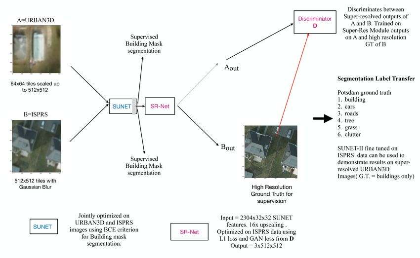
Fig. 1. Overview of Unsupervised Domain Adaptation based super-resolution of remote sensing imagery

and low resolution URBAN3D images have building foot-            2304 channels of dimension 32x32. These are passed through
print annotations. We train a building footprint segmentation    9x9 convolution filters that reduce the number of channels, a
network jointly on both datasets. We use mixed mini-batches      residual block, a 3x3 convolution layer and finally four con-
of samples from source and target domains during train-          secutive up-sampling modules that deploy pixel shuffling to
ing. Joint optimization on a shared task is used to align        generate 512x512 feature maps. The final convolution layer
deep features extracted from both kinds of data. The fea-        generates super-resolved three channel output tiles of size
tures of the building segmentation network are further used      512x512.
for super-resolution. For building segmentation we use the
stacked U-Net (SUNET) architecture as proposed is [23] and            Adversarial Learning Direct supervision on SR-Net
adapted to satellite imagery in [24]. SUNET consists of 4        is not available for URBAN3D dataset. To address this,
blocks of stacked U-Nets containing 2,7,7 and 1 U-Net mod-       we use an adversarial network to discriminate between the
ule(s) respectively. Every module is preceded and succeeded      super-resolved outputs generated by SR-Net and real high-
by 1x1 convolutions for feature transformation. Input images     resolution imagery. The discriminator network(D) is trained
pass through 7x7 convolution filters (stride=2) and a residual   on high resolution tiles from ISPRS data and outputs of SR-
block. For an input size of 512x512, the output map size is      Net on URBAN3D samples. The predictions of D on outputs
32x32, This is owing to 2 strided convolutions and 2 average     of SR-Net are used to compute the adversarial loss. Adversar-
pooling operations. Dilated convolutions are used to keep        ial loss for super-resolution was proposed for SR-GAN [18]
feature map resolution constant across U-Net modules. The        in conjunction with MSE loss for supervision. We use adver-
total number of parameters learned is 37.7 million.              sarial loss along with a stage-wise mix of L2 and L1 losses
                                                                 instead.
   Super-Resolution Module The super-resolving deep net-         Loss functions Besides the adversarial loss from the discrim-
work (SR-Net) consists of pixel shuffle layers [25] that up-     inator network, we use binary cross entropy (BCE) criterion
sample feature maps to 512x512 high resolution output tiles.     to supervise SUNET for the building footprint segmentation
The output feature maps of the segmentation network have         task. SR-Net is trained using adversarial loss as well as direct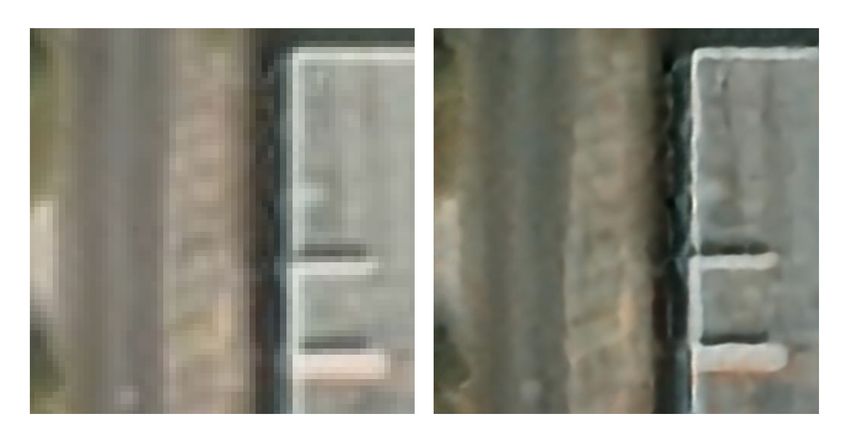
supervision on source domain samples. In the initial 1000 network on 512x512 training samples from two datasets.
epochs of training we use L2 loss on SR-Net output. L1 Dataset A: URBAN3D Samples consist of ortho-rectified
loss is used in subsequent epochs. L1 preserves colors and RGB images at 50 cm ground sample distance. Labels are
luminance. An error is weighed equally regardless of the building footprints and background.
local structure. Following the trends reported in [26], we opt Dataset B: ISPRS Potsdam 2D Semantic labeling contest
for using L2 loss initially to ensure the generator network samples are RGB orthophotos at 5cm ground sample distance.
(SR-Net) learns slowly enough to not outpace the discrimina- The dataset contains 38 patches of same size. Labels consist
tor. After that, we opt for L1 which is reported to provide a of 6 semantic classes - building, cars, trees, low vegetation,
steeper descent in loss curves [26]. roads(Impervious surfaces), clutter(background).
Material label transfer Our objective is to harvest the For training the networks, we sample 64x64 tiles from im-
rich and highly detailed semantic/material annotations from ages in A and scale them to 512x512 using bi-linear interpo-
the high resolution dataset to make inference on the super- lation (BLI). We crop 512x512 tiles from samples in B and
resolved URBAN3D images. ISPRS annotations cover 6 se- introduce Gaussian blur. SUNET is jointly optimized using
mantic classes. URBAN3D on the other hand provides build- binary cross entropy (BCE) loss on samples from both A and
ing footprint labels only. Material labels are harder to obtain B to perform building footprint segmentation. The features
than semantic labels. Moreover, in low resolution satellite of SUNET are thus aligned for both datasets and further used
imagery, it is difficult even for human annotators to reliably for super-resolution using 4 pixel-shuffling layers in SR-Net.
predict material labels of urban structures (e.g. building roofs, SR-Net layers are initialized using [27] and supervised using
roads, pavements etc.). Therefore, direct annotation of large high resolution ground truth tiles from source domain (IS-
quantities of training data is challenging. An alternative so- PRS). We apply an adversarial loss on outputs (for samples
lution to this problem is to obtain smaller quantities of urban of A and B) using a discriminator network D. D is trained to
material labels on high resolution datasets. UDA techniques discriminate between super-resolved outputs on A and high
can thereafter be used for automatic label transfer from source resolution ground truth tiles from B. Network parameters are
to target domain. Super-resolution can increase the fidelity of optimized using the RMSProp algorithm [28]. The models
such transfer by bridging the domain gap and enhancing cer- are implemented in PyTorch. Figure 2 shows drop in L1 loss
tain texture information. It can also help with enhanced de- during training on ISPRS samples. Computing L1 loss in tar-
tection of outlier regions (small objects on roof, shadows etc.) get domain (URBAN3D) is not possible because of lack of
high resolution data. Figure 3 shows super-resolved outputs
on some tiles from the URBAN3D data.
5. DISCUSSION
Compared to URBAN3D data, ISPRS images have ten times
higher resolution. The segmentation network (SUNET) is
provided with 512x512 upscaled inputs generated from 64x64
tiles randomly cropped from URBAN3D samples. The IS-
PRS input samples in the mixed training batches are obtained
by randomly cropping 512x512 tiles. Thus the inputs from the
two domains are at slightly different zoom levels. Moreover,
in order to simulate lower resolution inputs corresponding to
ISPRS images, we introduce a Gaussian blur. URBAN3D
Fig. 2. L1 loss computed on output of SR-Net for training dataset consists of images from Jacksonville, FL. Different
samples from ISPRS dataset lighting, abundance(or lack) of water bodies and different
nature of vegetation at Potsdam and Jacksonville contribute
to the domain gap between these two datasets. The pro-
posed approach overcomes this gap and learns to improve
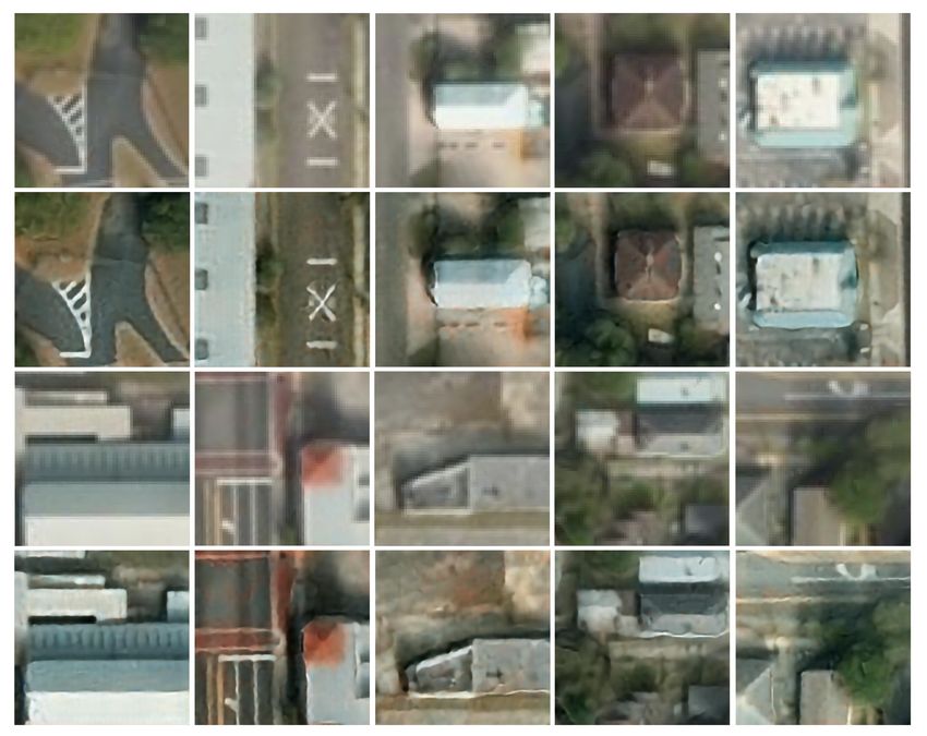
4. EXPERIMENTS the resolution of URBAN3D images. Figure 3 shows sev-
eral examples where boundaries of tiny buildings are much
We augment the Stacked U-Net (SUNET) architecture used sharper in the output, road markings are clearer and details
for land cover classification [24] for unsupervised satellite im- such as small structures (chimneys), roof shape, shadows
agery super-resolution using adversarial learning. We initial- are enhanced. Figure 4 provides a specific example where
ize the SUNET with pre-trained weights from the DeepGlobe boundaries between different materials (structures on a roof)
land cover classification challenge. We jointly optimize the are enhanced.Fig. 3. Super-resolved remote sensing imagery from URBAN3D dataset. First and third row consist of original low resolution
64x64 tiles whereas second and fourth contain their super-resolved 512x512 versions.
6. ACKNOWLEDGEMENTS
The research is based upon work supported by the Office of
the Director of National Intelligence (ODNI), Intelligence
Advanced Research Projects Activity (IARPA), via DOI/IBC
Contract Number D17PC00287. The views and conclusions
contained herein are those of the authors and should not be
interpreted as necessarily representing the official policies
or endorsements, either expressed or implied, of the ODNI,
IARPA, or the U.S. Government. The U.S. Government is
Fig. 4. Super resolution results in more clear boundaries be- authorized to reproduce and dis- tribute reprints for Govern-
tween different material types on a roof mental purposes notwithstanding any copyright annotation
thereon.7. REFERENCES [11] C. R. De Souza, A. Gaidon, Y. Cabon, and A. M. L.
Peña, “Procedural generation of videos to train deep ac-
[1] F. Rottensteiner, G. Sohn, J. Jung, M. Gerke, C. Baillard, tion recognition networks.” in CVPR, 2017, pp. 2594–
S. Benitez, and U. Breitkopf, “The isprs benchmark on 2604.
urban object classification and 3d building reconstruc-
tion,” ISPRS Ann. Photogramm. Remote Sens. Spat. Inf. [12] L. Hu, M. Kan, S. Shan, and X. Chen, “Duplex genera-
Sci, vol. 1, no. 3, pp. 293–298, 2012. tive adversarial network for unsupervised domain adap-
tation,” in Proceedings of the IEEE Conference on Com-
[2] H. R. Goldberg, S. Wang, G. A. Christie, and M. Z. puter Vision and Pattern Recognition, 2018, pp. 1498–
Brown, “Urban 3d challenge: building footprint de- 1507.
tection using orthorectified imagery and digital surface
models from commercial satellites,” in Geospatial In- [13] H. Li, S. J. Pan, S. Wang, and A. C. Kot, “Domain gen-
formatics, Motion Imagery, and Network Analytics VIII, eralization with adversarial feature learning,” in Proc.
vol. 10645. International Society for Optics and Pho- IEEE Conf. Comput. Vis. Pattern Recognit.(CVPR),
tonics, 2018, p. 1064503. 2018.
[3] S. Sankaranarayanan, Y. Balaji, A. Jain, S. N. Lim, [14] S.-A. Rebuffi, H. Bilen, and A. Vedaldi, “Efficient
and R. Chellappa, “Learning from synthetic data: Ad- parametrization of multi-domain deep neural networks,”
dressing domain shift for semantic segmentation,” arXiv in Proceedings of the IEEE Conference on Computer Vi-
preprint arXiv:1711.06969, 2017. sion and Pattern Recognition, 2018, pp. 8119–8127.
[4] Z. Ren and Y. J. Lee, “Cross-domain self-supervised [15] R. Volpi, P. Morerio, S. Savarese, and V. Murino, “Ad-
multi-task feature learning using synthetic imagery,” in versarial feature augmentation for unsupervised domain
Proceedings of the IEEE Conference on Computer Vi- adaptation,” in Proceedings of the IEEE Conference on
sion and Pattern Recognition (CVPR), vol. 5, 2018. Computer Vision and Pattern Recognition, 2018, pp.
5495–5504.
[5] K. Bousmalis, N. Silberman, D. Dohan, D. Erhan, and
D. Krishnan, “Unsupervised pixel-level domain adapta- [16] Y. Li, X. Tian, M. Gong, Y. Liu, T. Liu, K. Zhang, and
tion with generative adversarial networks,” in The IEEE D. Tao, “Deep domain generalization via conditional in-
Conference on Computer Vision and Pattern Recogni- variant adversarial networks,” in Proceedings of the Eu-
tion (CVPR), vol. 1, no. 2, 2017, p. 7. ropean Conference on Computer Vision (ECCV), 2018,
pp. 624–639.
[6] X. Guo, H. Li, S. Yi, J. Ren, and X. Wang, “Learning
monocular depth by distilling cross-domain stereo net- [17] Y. Zhang, Z. Qiu, T. Yao, D. Liu, and T. Mei, “Fully con-
works,” in Proceedings of the European Conference on volutional adaptation networks for semantic segmenta-
Computer Vision (ECCV), 2018, pp. 484–500. tion,” in Proceedings of the IEEE Conference on Com-
puter Vision and Pattern Recognition, 2018, pp. 6810–
[7] A. Atapour-Abarghouei and T. P. Breckon, “Real-time 6818.
monocular depth estimation using synthetic data with
domain adaptation via image style transfer,” in Proceed- [18] C. Ledig, L. Theis, F. Huszár, J. Caballero, A. Cunning-
ings of the IEEE Conference on Computer Vision and ham, A. Acosta, A. P. Aitken, A. Tejani, J. Totz, Z. Wang
Pattern Recognition, vol. 18, 2018, p. 1. et al., “Photo-realistic single image super-resolution us-
ing a generative adversarial network.” in CVPR, vol. 2,
[8] Y. Chen, W. Li, and L. Van Gool, “Road: Reality no. 3, 2017, p. 4.
oriented adaptation for semantic segmentation of ur-
ban scenes,” in Proceedings of the IEEE Conference [19] X. Wang, K. Yu, S. Wu, J. Gu, Y. Liu, C. Dong,
on Computer Vision and Pattern Recognition, 2018, pp. C. C. Loy, Y. Qiao, and X. Tang, “Esrgan: Enhanced
7892–7901. super-resolution generative adversarial networks,” arXiv
preprint arXiv:1809.00219, 2018.
[9] Z. Wu, X. Han, Y.-L. Lin, M. G. Uzunbas, T. Goldstein,
S. N. Lim, and L. S. Davis, “Dcan: Dual channel-wise [20] D. Ravı̀, A. B. Szczotka, D. I. Shakir, S. P. Pereira, and
alignment networks for unsupervised scene adaptation,” T. Vercauteren, “Adversarial training with cycle con-
arXiv preprint arXiv:1804.05827, 2018. sistency for unsupervised super-resolution in endomi-
croscopy,” 2018.
[10] L. Yang, X. Liang, T. Wang, and E. Xing, “Real-to-
virtual domain unification for end-to-end autonomous [21] Y. Yuan et al., “Unsupervised image super-resolution
driving,” in Proceedings of the European Conference on using cycle-in-cycle generative adversarial networks,”
Computer Vision (ECCV), 2018, pp. 530–545. methods, vol. 30, p. 32, 2018.[22] G. Lin, Q. Wu, L. Chen, L. Qiu, X. Wang, T. Liu, and
X. Chen, “Deep unsupervised learning for image super-
resolution with generative adversarial network,” Signal
Processing: Image Communication, vol. 68, pp. 88–
100, 2018.
[23] S. Shah, P. Ghosh, L. S. Davis, and T. Goldstein,
“Stacked u-nets: a no-frills approach to natural image
segmentation,” arXiv preprint arXiv:1804.10343, 2018.
[24] A. Ghosh, M. Ehrlich, S. Shah, L. Davis, and R. Chel-
lappa, “Stacked u-nets for ground material segmentation
in remote sensing imagery,” in Proceedings of the IEEE
Conference on Computer Vision and Pattern Recogni-
tion Workshops, 2018, pp. 257–261.
[25] W. Shi, J. Caballero, F. Huszár, J. Totz, A. P. Aitken,
R. Bishop, D. Rueckert, and Z. Wang, “Real-time single
image and video super-resolution using an efficient sub-
pixel convolutional neural network,” in Proceedings of
the IEEE Conference on Computer Vision and Pattern
Recognition, 2016, pp. 1874–1883.
[26] H. Zhao, O. Gallo, I. Frosio, and J. Kautz, “Loss func-
tions for image restoration with neural networks,” IEEE
Transactions on Computational Imaging, vol. 3, no. 1,
pp. 47–57, 2017.
[27] K. He, X. Zhang, S. Ren, and J. Sun, “Delving deep
into rectifiers: Surpassing human-level performance on
imagenet classification,” in Proceedings of the IEEE in-
ternational conference on computer vision, 2015, pp.
1026–1034.
[28] T. Tieleman and G. Hinton, “Lecture 6.5-rmsprop: Di-
vide the gradient by a running average of its recent
magnitude,” COURSERA: Neural networks for machine
learning, vol. 4, no. 2, pp. 26–31, 2012.You can also read