Urban Forest Strategy 2021 28 - DRAFT - Prepared by Strategic, Design and Sustainability Planning - Greater Dandenong
←
→
Page content transcription
If your browser does not render page correctly, please read the page content below
DRAFT                                                       City of Greater Dandenong
                                                                Urban Forest Strategy

Urban Forest Strategy 2021 – 28

Prepared by Strategic, Design and Sustainability Planning

                                           Page | 1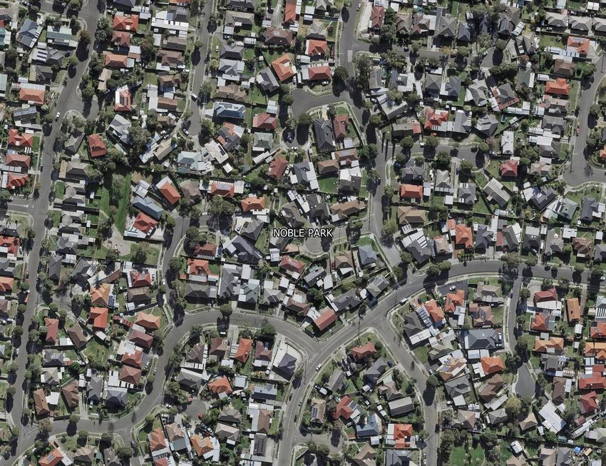
DRAFT                                                                                                                   City of Greater Dandenong
                                                                                                                             Urban Forest Strategy

Contents

Mayor’s Forward ........................................................................................................................ 3
Executive Summary.................................................................................................................... 4
1. Introduction ........................................................................................................................... 6
   1.1 Policy context ................................................................................................................... 7
   1.2 What is an urban forest? .................................................................................................. 8
   1.3 What is the urban heat island? ...................................................................................... 10
   1.4 Background..................................................................................................................... 10
   1.5 Climate change and our community .............................................................................. 12
2. Vision .................................................................................................................................... 13
3. Objectives............................................................................................................................. 13
4. Benefits ................................................................................................................................ 14
5. Mapping of Greater Dandenong’s canopy coverage ........................................................... 16
   5.1 Canopy cover .................................................................................................................. 17
   5.2 Land use assessment ...................................................................................................... 19
6. Urban heat ........................................................................................................................... 23
7. Social vulnerability and health ............................................................................................. 25
8. Defining the action plans ..................................................................................................... 29
9. Monitoring and review ........................................................................................................ 29
Glossary .................................................................................................................................... 30
Bibliography ............................................................................................................................. 32

                                                                     Page | 2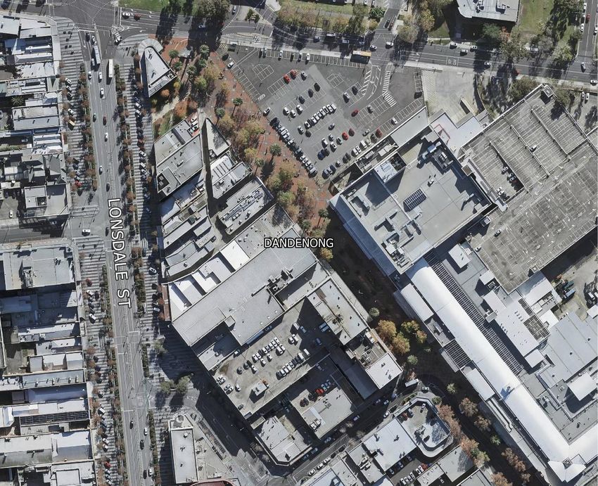
DRAFT                          City of Greater Dandenong
                                   Urban Forest Strategy

Mayor’s Forward

To be determined.

                    Page | 3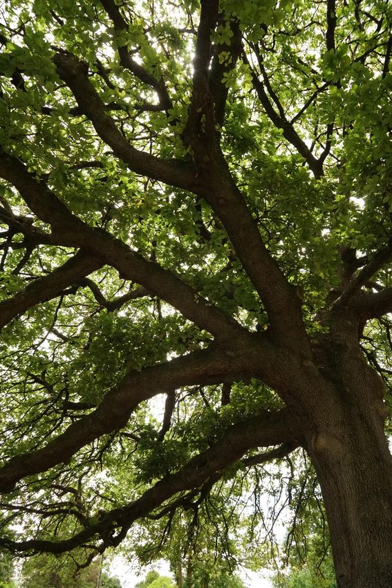
DRAFT                                                                          City of Greater Dandenong
                                                                                   Urban Forest Strategy

Executive Summary

The City of Greater Dandenong’s Urban Forest Strategy provides a holistic approach to
delivering a healthy, green and resilient urban forest. The City of Greater Dandenong’s
urban forest includes all vegetation, big and small growing on private and public land.
Vegetation, particularly canopy trees deliver immense economic, social and environmental
benefits including shade, streetscape amenity, air pollution reduction, habitat for wildlife
and help tackle and respond to climate change.

Climate change is already impacting our municipality through increased average daily
temperatures, less rainfall and increased intensity of storm and fire events. On average,
Melbourne’s urban areas are over 8°C hotter than non-urban areas, and our changing
climate will only increase the risks (Department of Environment, Land, Water and Planning
(DELWP), 2019). Therefore, it is critical that we take action to increase tree cover in urban
areas.

On 28 January 2020 Greater
Dandenong City Council declared a
‘Climate and Ecological Emergency’
committing Council to emergency
action on climate change. Enhancing
our urban forest will play a significant
role in mitigating against the impacts
of climate change by helping to:

   •   drawdown carbon emissions
   •   cool our urban environment
   •   reduce our community’s risk to climate change.

The City of Greater Dandenong will be impacted to a greater extent by climate change’s
effects on our local urban heat island than our greener, neighbouring suburbs due to our
very low canopy cover (9.9 per cent). Unless we can increase canopy cover in the City of
Greater Dandenong this will further impact our community, already recognised as the most
disadvantaged municipality in metropolitan Melbourne. This is because vulnerable people,
such as the elderly, children and those from low socio-economic backgrounds are at an even
greater risk to extreme heat events and a changing climate.

                                             Page | 4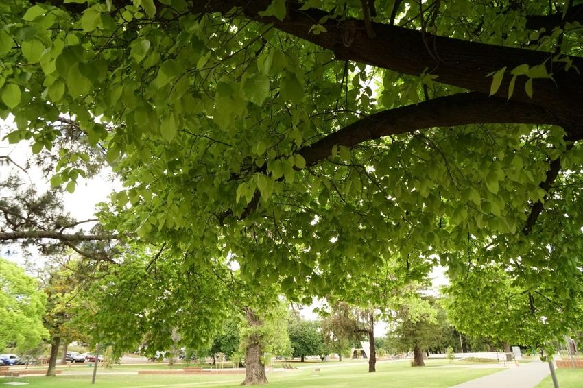
DRAFT                                                                        City of Greater Dandenong
                                                                                 Urban Forest Strategy

The City of Greater Dandenong’s Urban Forest Strategy is the overarching document to:

   •   Greening Our City: Urban Tree Strategy 2018-28 which considers the current status,
       issues and opportunities for Council managed trees
   •   Greening Our Neighbourhoods 2021-28 which considers the current issues and
       opportunities for trees on privately owned land.

The Urban Forest Strategy has set a vision for:

       A healthy, green and resilient urban forest that is well managed, protected and
       provides benefits to the community.

The key objectives that Council aims to work towards are:

   1. Provide a framework for managing and enhancing our urban forest
   2. Improve the City of Greater Dandenong’s resilience to the unavoidable impacts of
      climate change
   3. Cool through greening our city
   4. Improve the health and wellbeing of our community
   5. Engage and educate our community about the importance of trees.

Council aims to increase its canopy cover to 15 per cent by 2028, by strategically planting
more trees on publicly owned land in locations of greatest need and advocating for higher
quality landscaping and canopy trees on privately-owned land.

                                             Page | 5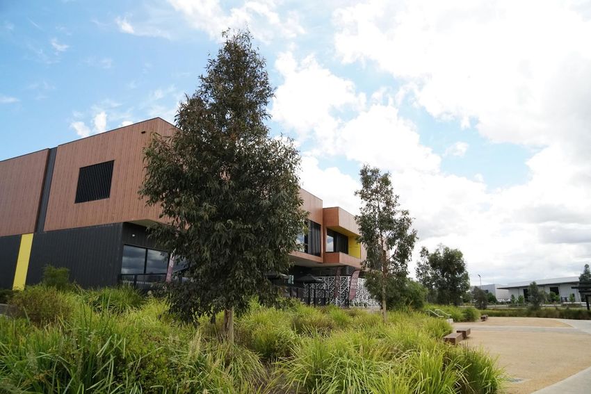
DRAFT                                                                        City of Greater Dandenong
                                                                                 Urban Forest Strategy

1. Introduction

The Urban Forest Strategy 2021-28 is viewed as a direct response to climate change and a
way in which Council can significantly help drawdown carbon levels and improve the
community’s resilience to the unavoidable effects of a changing climate. The City of Greater
Dandenong currently has a very low tree canopy cover of 9.9 per cent. This is the lowest of
all metropolitan Melbourne municipalities on the eastern side of Melbourne. Low canopy
cover has contributed to more severe urban heat island impacts with our municipality
identified as the 7th hottest metropolitan municipality in Melbourne.

Based on the findings of the 2016 Census, the 2016 Index of Relative Socio-economic
Disadvantage ranked the City of Greater Dandenong as the most disadvantaged municipality
in metropolitan Melbourne.

The municipality’s existing low level of canopy cover puts the City of Greater Dandenong
community at an even greater risk to the impacts of climate change, including heat-related
illnesses and stress. An urban forest includes all types of vegetation and ecosystems. It is
made up of trees, shrubs, grasslands, and increasingly rooftop gardens and green walls
growing on public and private land. Growing our urban forest is essential to playing our part
in reducing carbon emissions and improving the community’s resilience.

The Urban Forest Strategy 2021-28 is the strategic document that provides the overarching
support to the Greening Our City: Urban Tree Strategy 2018-28 and the Greening Our
Neighbourhoods Strategy 2021-28. Together these three strategies will help Council manage
and enhance the urban forest and provide a roadmap to create a cooler greener city that
benefits our community’s health and wellbeing. The target is to increase the City of Greater
Dandenong’s canopy cover to 15 per cent by 2028.

Figure 1 Structure of Urban Forest suite of strategies

                                                         Page | 6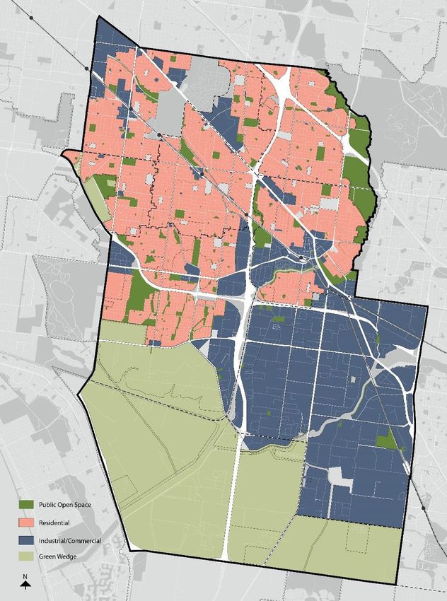
DRAFT                                                                                   City of Greater Dandenong
                                                                                                    Urban Forest Strategy

        1.1 Policy context
        The Urban Forest Strategy, encompassing Greening Our City and Greening Our
        Neighbourhoods will help deliver Council’s strategic objective ‘A healthy, liveable and
        sustainable city’ by planting more trees in our streets and parks, engaging with the
        community to increase their awareness of the environment and enhancing the ecological
        value of all land within the municipality. The Urban Forest Strategy also directly responds to
        Objective 1.5 of Council’s existing Community Wellbeing Plan by preparing ‘for climate
        change and its impact on the health and wellbeing of the community’.

        Figure 2 demonstrates the relationship between the Urban Forest Strategy and it’s two
        parts, as well as with other relevant Council documents.

Figure 2 Policy Context and Hierarchy of Urban Forest Strategy and relevant Council documents

        The Urban Forest Strategy is informed by multiple state strategic documents including the
        Local Government Act 2020, the Climate Change Act 2017 and the Victorian Government’s
        2017 Climate Change Adaptation Plan which all identify Council’s vital role and obligation to
        mitigate and plan for climate change risks in areas such as land-use planning, infrastructure,
        health, emergency management, community services and environmental management.

        In addition to these, the Urban Forest Strategy has considered Plan Melbourne 2017-2050
        and Living Melbourne: Our Metropolitan Urban Forest Strategy (2019) which recognise an
        urgent need for Melbourne to adapt to climate change and increase canopy cover,
        particularly on privately-owned land, to respond to and mitigate the impacts of the urban
        heat island. Plan Melbourne also recognises that green wedges are vital to long-term food
        security due to their proximity to markets, quality soils and access to infrastructure and
        labour.

                                                            Page | 7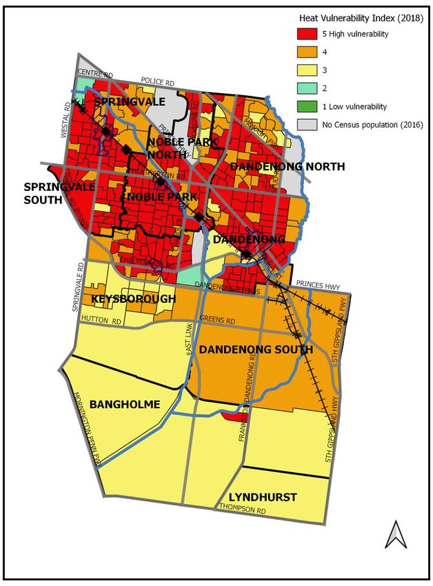
DRAFT                                                                          City of Greater Dandenong
                                                                                   Urban Forest Strategy

Council’s 2018 Greening Our City identified the City of Greater Dandenong has a low canopy
cover of 9.9%, the lowest for a municipality on the eastern side of Melbourne, as a key issue
facing the municipality. To address this issue Greening Our City sets out an action plan to
increase the canopy cover across public and private land to 15 per cent by 2028. In response
to the community feedback received during consultation, Greening Our City also identifies
the need to protect and increase vegetation on private land. The Urban Forest Strategy is in
direct response to these considerations and will ensure a holistic approach to managing and
enhancing our urban forest.

Additionally, Council has a suite of strategies (shown in Figure 2) which set clear objectives
to deliver ‘a healthy, liveable and sustainable city’ and commits to responding to climate
change through mitigation and adaptation, including increasing canopy cover, working with
key stakeholders and increasing biodiversity.

                                             Page | 8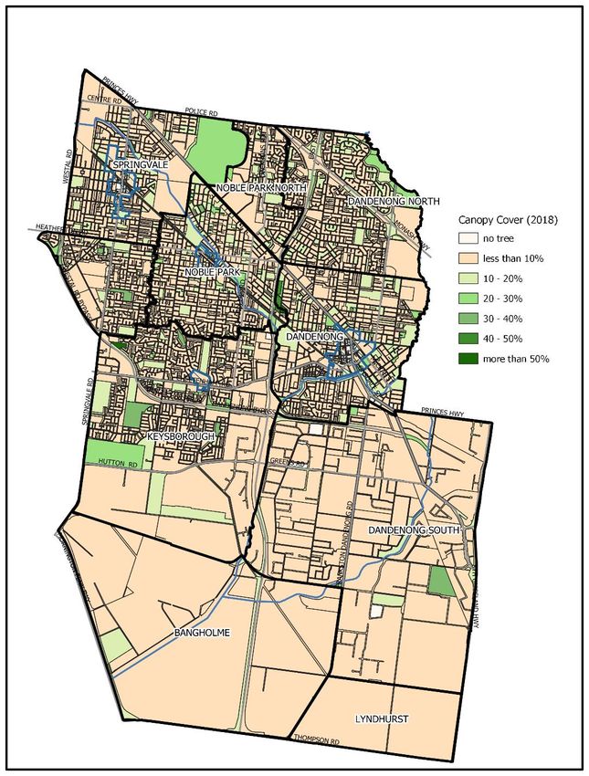
DRAFT                                                                         City of Greater Dandenong
                                                                                          Urban Forest Strategy

        1.2 What is an urban forest?
        While the term may conjure up images of giant gum trees, an ‘urban forest’ includes all the
        vegetation (trees, shrubs, groundcovers, grasses), big and small growing on private and
        public land. The expansive grassland of the Green Wedge, the River Red Gums which line
        our parks, the vines which grow over patios and the fruit trees and vegetable gardens which
        fill our backyards are all part of the City of Greater Dandenong’s urban forest. As well as
        providing a greener cooler city, urban forests also help provide habitat for our local
        biodiversity.

        For Greater Dandenong Council, the urban forest is as much about greening our streets,
        buildings, car parks and industrial precincts as it is about greening our gardens and our
        homes.

*Images on this page are placeholders and have not been
finalised.

                                                          Page | 9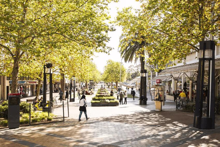
DRAFT                                                                                             City of Greater Dandenong
                                                                                                      Urban Forest Strategy

1.3 What is the urban heat island?
The term “urban heat island” refers to the temperature difference between urban and non-
urban areas. Figure 3 demonstrates an urban heat island with hotter temperatures
associated with built up areas and cooler temperatures with parks and rural land. There is
significant evidence that the urban heat island is a major issue facing all Australian cities and
is likely to worsen with more extreme weather events if no action is taken. The urban heat
island is having devastating impacts on human health and on vulnerable communities who
are more susceptible to extreme heat and its effects. As the occurrence and intensity of
extreme heat events increase with climate change, the risk of adverse impacts on human
health is increasing. As well as the pressure on health services, including those that local
governments provide (Climate Council, 2016).

Urban heat islands are worsened by a lack of shade trees and higher proportion of hard and
dark surfaces which retain and radiate heat. For the Greater Dandenong municipality, this is
a key issue which must be addressed.

 Figure 3 Western Sydney Regional Organisation of Councils 2018, Turn Down the Heat Strategy and Action Plan

                                                       Page | 10
DRAFT City of Greater Dandenong
Urban Forest Strategy
1.4 Background
On 23 July 2018 Council adopted Greening Our City: Urban Tree Strategy 2018-28. Greening
Our City considers the current status, issues and opportunities for Council managed trees
(street and park trees of Greater Dandenong) and sets a canopy cover target of 15 per cent
by 2028 across the entire municipality.
Greening our City identified that the City of Greater Dandenong has a very low canopy cover
of 9.9 per cent and hence, the strategy set a series of actions and targets for Council’s
ongoing tree planting programs until 2028. By strategically planting more trees in locations
of greatest need, Council aims to increase canopy cover on publicly owned land.
Greening our City also recognised the need to protect and enhance trees on privately-
owned land to help achieve the targeted canopy cover. To address this, the strategy
proposed the development of an Urban Forest Strategy which provides a holistic context for
the management of the urban forest.
The second part of the Urban Forest Strategy, Greening our Neighbourhoods Strategy 2021-
28 responds to this need and presents the current challenges and opportunities to
increasing canopy cover on privately-owned land. The Urban Forest Strategy aims to
understand how Council and the community can enhance and manage the urban tree
canopy on both public and privately-owned land.
Page | 11DRAFT City of Greater Dandenong
Urban Forest Strategy
1.5 Climate change and our community
Greater Dandenong City Council, on 28 January 2020
declared a ‘Climate and Ecological Emergency’ and on 24
August 2020 Council adopted the Climate Emergency
Strategy 2020-2030 and Action Plan committing Council
to emergency action on climate change. The urban forest
plays a significant role in mitigating against climate
change by cooling our urban environment.
As part of the community consultation undertaken to inform the Climate Emergency
Strategy 2020-2030, Council found that 92 per cent of respondents were worried about
climate change, and 94 per cent believed it was important that Greater Dandenong City
Council take action.
Climate change is already affecting our environment, our society and our economy. The key
challenges facing our municipality include an increased average daily temperature, higher
maximum temperatures, less rainfall and increased intensity of storm events and fire
weather.
The City of Greater Dandenong is the most disadvantaged municipality in metropolitan
Melbourne which is further compounded by very lower canopy cover of 9.9 per cent.
Vulnerable people, such as the elderly, children, people living with a disability and those
from low socio-economic backgrounds are at an even greater risk to extreme heat events,
increased financial pressures and a changing climate.
It is clear climate change will worsen heatwave events, increasingly affecting the health and
wellbeing of our community. Local governments have a key role in facilitating their
municipalities to be cooler and greener as part of their response to climate change, to
deliver the best outcomes for their community. For Greater Dandenong City Council, the
need to respond is even greater, as many members of our community lack the resources to
either prepare for or respond to the impacts of heat waves and other climate change
related risks. This is due to some living in old, poorly insulated housing which heat up quickly
or being unable to afford to turn on the air conditioner to cool the home.
Evidence shows that planting canopy trees is a strong and effective response to these
effects. Not only do trees significantly cool our urban environment, they also provide a
sense of calmness and improved aesthetic values for our streets and gardens. Being
connected with nature through access to fresh air, shade and pleasant spaces to move
through, relax and recreate in is vital to our mental and physical wellbeing.
The Urban Forest Strategy will help respond and reduce the effects of climate change, build
resilience in our community and create a more visually appealing municipality.
Page | 12DRAFT City of Greater Dandenong
Urban Forest Strategy
2. Vision
A healthy, green and resilient urban forest that is well managed, protected and provides
benefits to the community.
3. Objectives
Council has set five objectives to guide the management and enhancement of its urban
forest:
1. Provide a framework for managing and enhancing our urban forest
To assist Council and the community in making informed decisions about tree
canopy on public and private land within the municipality in line with the 15-year
tree planting program.
2. Improve the City of Greater Dandenong’s resilience to the unavoidable impacts of
climate change
Proactively mitigate against climate change and drawdown carbon emissions by
increasing canopy cover in streets, public open spaces and on privately-owned land
and transitioning towards more suitable species to improve the health and diversity
of our urban forest and our resiliency to climate change.
3. Cool through greening our city
Fill all vacant street tree sites and encourage private landowners to protect and
enhance landscaping to cool our city, promote integrated water management to
support our urban forest and increase canopy cover across the municipality to 15 per
cent by 2028.
4. Improve the health and wellbeing of our community
Cool the urban environment to improve access to nature and reduce the risk of heat
related illness to improve the health and wellbeing of our community.
5. Engage and educate the community about the importance of trees
Deliver community educational programs to develop the knowledge of landowners
and residents on vegetation selection and maintenance, and to improve perceptions
of trees by demonstrating their importance in the urban environment.
Page | 13DRAFT City of Greater Dandenong
Urban Forest Strategy
4. Benefits
*the list of benefits will be graphically designed
Our climate is becoming hotter and drier, with more extreme weather events which we
need to mitigate and adapt to. Growing our urban forest is one of the most effective ways
to tackle urban heat island impacts and mitigate against climate change. Trees and
vegetation directly help reduce urban heat island effects by shading buildings and other
hard surfaces, deflecting radiation from the sun and releasing moisture into the
atmosphere. More broadly, the wide range of benefits for our municipality include:
Environmental
- Canopy trees help cool urban environments and can reduce daytime surface
temperatures by between 5-20°C
- Through photosynthesis a tree can capture and store up to 150kg of CO² per annum,
this is known as carbon sequestration
- Trees support a healthy and diverse ecosystem by providing habitat and wildlife
corridors for local and migratory wildlife
- Trees can help regulate stormwater runoff, reducing demand on drainage
infrastructure, reducing intensity of localised flood and assisting in the improvement
of water quality. For every 5 per cent of tree cover added to a landscape, storm
water runoff is reduced by approximately 2 per cent
- Trees filter airborne pollutants and there is up to a 60 per cent reduction in street
level particulates where trees are present
- Trees act as wind buffers on agricultural land minimising the loss of topsoil and
providing shelter to grazing animals.
Economic
- Tree-lined streets attract more foot traffic and can lead to increased spending and
investment. Trees incorporated into commercial and retail precincts can increase
business income by 20 per cent1
- Residential land values can increase in streets with street trees, compared to nearby
streets with no street trees2
- Office workers with a view of nature are more productive, report fewer illnesses and
have higher job satisfaction.
1
(Georgia Urban Forestry Publication, 2004; Mullaney, Lucke, & Trueman, 2015)
2
(Pandita, Polyakovb, Tapsuwanc, & Morand, 2013; Mullaney, Lucke, & Trueman, 2015; Pandit, Polyakov, &
Sadler, 2012; Moore, 2020)
Page | 14DRAFT City of Greater Dandenong
Urban Forest Strategy
- Appropriately placed trees can realise financial savings up to 50 per cent on daytime
air conditioning for businesses3
- Shade trees can assist in prolonging the life of infrastructure4
- The presence of nature, access to clean air and cooler environments improves
human health by reducing stress and blood pressure thus reducing demand on
health systems
- Vegetation, such as fruit trees or vines and vegetable gardens, contribute to local
food production which can lead to reduced grocery costs and healthier communities
Social
- Reduce daytime air temperatures by 1-2°C during extreme heat events, which can
significantly reduce heat mortality rates for elderly and vulnerable people
- Reduced heat-related illnesses including heat exhaustion, damage to medications
and stress
- Removes pollution in the air, mitigating and alleviating respiratory problems such as
asthma and other chronic lung conditions5
- Reduced vulnerability to extreme heat events
- Leafy areas can provide a comfortable outdoor place to gather with loved ones and
build community networks
- Help strengthen communities by promoting contact, encouraging physical activity,
reducing stress and stimulating social cohesion
- Contribute to a safer neighbourhood through appropriate design responses
- Provide protection against skin cancer by reducing UV-B exposure (the most
damaging type of solar radiation) by approximately 50%
- Children function better than usual after activities in green settings, and ‘greener’
play areas can lead to less severe attention deficit symptoms6
- Spending time near trees improves physical and mental health by increasing energy
levels, reducing stress and decreasing blood pressure
- Treed landscapes foster active and passive recreation aiding in increased physical
and mental health
- Exposure to nature while young can influence a person’s lifelong attitude to
environmental protection
- Trees promote positive perceptions and connections with nature
3
(Georgia Urban Forestry Publication, 2004; Mullaney, Lucke, & Trueman, 2015; Moore, 2020)
4
(Moore, 2020)
5
(Georgia Urban Forestry Publication, 2004; Moore, 2020)
6
(Taylor, Kuo, & Sullivan, 2001)
Page | 15DRAFT City of Greater Dandenong
Urban Forest Strategy
Amenity
- Trees enhance our neighbourhoods and are considered the most important indicator
of attractiveness in a community
- Vegetation contributes to the character of a neighbourhood
- Trees absorb sound waves, reducing urban noise
- Trees frame and screen views, and soften the built environment
- Variety in the shape, texture and colour of trees and vegetation contributes to visual
amenity and interest
- Natural barrier to wind
Page | 16DRAFT City of Greater Dandenong
Urban Forest Strategy
5. Mapping of Greater Dandenong’s canopy coverage
5.1 Canopy cover Table 1 Based on Hurley et al., 2018
To inform Greening Our City: Urban Tree Strategy 2018-28, Tree Canopy Cover
Council measured the municipality’s canopy cover using a (Metropolitan Melbourne Councils)
point sampling tool called i-Tree Canopy 1 Yarra Ranges (S)
(www.canopy.itreetools.org) in 2017 and determined that 2 Nillumbik (S)
canopy cover for Greater Dandenong was 9.9 per cent. 3 Manningham (C)
4 Maroondah (C)
To further inform our knowledge of canopy cover across 5 Boroondara (C)
Melbourne, in 2019, the Department of Environment, Land, 6 Mornington Peninsula (S)
Water and Planning released canopy mapping using Lidar 7 Banyule (C)
technology which allows for greater analysis of canopy cover 8 Whitehorse (C)
9 Stonnington (C)
and urban heat on both public and private land. This
10 Frankston (C)
methodology (using Lidar technology) has been used to gain 11 Knox (C)
a deeper understanding of the City of Greater Dandenong’s 12 Bayside (C)
vulnerability to the urban heat island and an understanding 13 Monash (C)
of how we can work to increase our overall canopy cover 14 Yarra (C)
and in turn reduce our risk to climate change. The Lidar 15 Glen Eira (C)
mapping method has been used to inform the following land 16 Port Phillip (C)
use and canopy discussion. 17 Cardinia (S)
18 Darebin (C)
By using both i-Tree and Lidar methodologies Council can 19 Casey (C)
provide a detailed analysis of canopy cover according to 20 Melbourne (C)
specific land uses (i.e. public or private, residential or 21 Moreland (C)
industrial) (Lidar) and ensure consistency for monitoring and 22 Kingston (C)
23 Moonee Valley (C)
reporting against the adopted target of 15 per cent (i-Tree)
24 Maribyrnong (C)
across the urban forest suite of strategies. 25 Whittlesea (C)
26 Greater Dandenong (C)
27 Brimbank (C)
28 Hume (C)
29 Hobsons Bay (C)
30 Wyndham (C)
31 Melton (C)
Page | 17DRAFT City of Greater Dandenong
Urban Forest Strategy
Page | 18
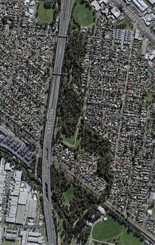
Figure 4 Map of Municipality showing canopy cover (Lidar, 2018) Figure 5 Map of Municipality showing basic land use in Greater DandenongDRAFT City of Greater Dandenong
Urban Forest Strategy
5.2 Land use assessment
The research7 on land use and canopy cover conducted in 2018 by the Centre for Urban
Research at RMIT University identified that residential land provides the largest contribution
to tree canopy cover across metropolitan Melbourne. However, due to a combination of
urban re-development, landowner land-management practices and climatic effects,
vegetation cover on residential land is decreasing.
In the City of Greater Dandenong 73 per cent of land is privately-owned, including
residential, industrial, commercial and rural zones (i.e. the Green Wedge). The remainder
(27 per cent) is publicly owned and includes parks, urban and civic spaces, footpaths, road
reserves and Council buildings and its associated land. Figures 4 and 5 demonstrates that
the majority of land within the City of Greater Dandenong is privately-owned and has less
than 10 per cent canopy cover.
Privately-owned land, which includes residential, industrial, commercial, rural land and all
land not owned by Council or the Crown, has a canopy cover of 5.6 per cent.
Publicly owned land which includes Council owned land, public open space, roads and
Crown land has a canopy cover of 9.1 per cent.
Low canopy cover greatly contributes to the urban heat island impacts and the liveability of
our urban environment. To ensure these effects are mitigated it is vital canopy cover is
increased, particularly on privately-owned land which accounts for 73 per cent of the
municipality.
The following maps provide examples of canopy cover seen across the Greater Dandenong
municipality.
7
(Hurley, et al., 2019) based on Lidar technology
Page | 19DRAFT City of Greater Dandenong
Urban Forest Strategy
Fotheringham Reserve (canopy
cover above 40 per cent)
Greaves Reserve (canopy cover
between 10-30 per cent)
Industrial area (canopy Figure 6 Canopy Cover Percentages (Lidar) - Fotheringham Reserve, Dandenong
cover less than 10 per cent)
Fotheringham Reserve in Dandenong has a canopy cover of over 40 per cent. This is
attributed to its creek environs, dense bushland and walking trails. Industrial areas have
typically less than 10 per cent canopy cover due to large site coverage requirements (for
building footprints and car parking).
Page | 20DRAFT City of Greater Dandenong
Urban Forest Strategy
Residential properties = Less than 10 per cent Road reserves = 10-20 per cent
Figure 7 Canopy cover percentages for residential areas and road reserves (Lidar) – Greater Dandenong
Council is working to increase the number of street trees through the Greening Our City
Strategy, as currently there is generally between 10-20 per cent canopy cover in road
reserves. Typically, most privately-owned residential areas support less than 10 per cent
canopy cover.
Page | 21DRAFT City of Greater Dandenong
Urban Forest Strategy
Figure 8 Palm Plaza (outlined in red) and Lonsdale Street, Dandenong
The mature trees in Palm Plaza and Lonsdale Street Dandenong, provide significant greening
and cooling benefits to the Dandenong Metropolitan Activity Centre (10-20 per cent canopy
cover ( (Hurley, et al., 2019), based on Lidar technology) The mature canopy trees ensure
this public space is walkable and pleasant to visit, as well as assisting in reducing the radiant
heat from the pavement, adjoining buildings, rooftops and carparks. Placemaking data
collected since 2015 has reported that Palm Plaza is the busiest outdoor public space in
central Dandenong.
Palm Plaza, Dandenong Lonsdale Street, Dandenong
Page | 22DRAFT City of Greater Dandenong
Urban Forest Strategy
6. Urban heat
The impact of climate change is one of the most significant drivers to grow our urban forest.
Climate change is expected to intensify the urban heat island (UHI) which presents
substantial challenges to all facets of our lives at a social, environmental and economic level.
The UHI refers to the temperature difference between urban and non-urban areas. There is
significant evidence that the UHI is a major issue facing all Australian cities and is likely to
worsen with more extreme weather events if no action is taken. The UHI is having
devastating impacts on human health and on vulnerable communities who are more
susceptible to extreme heat and its effects.
Research has shown that canopy trees can reduce daytime surface temperatures by
between 5-20°C. Canopy trees are one of the most effective mechanisms for reducing the
UHI effect by removing carbon dioxide from the air, and cooling through evapotranspiration
and shading hard or dark surfaces.
Due to the lack of canopy trees and the large extent of hard surfaces which absorb and
radiate heat across the municipality, the City of Greater Dandenong has been identified as
the 7th hottest municipality in metropolitan Melbourne (refer to Figure 9).
Whilst the Greater Dandenong municipality does have a very large industrial area with large
amounts of hard surfaces, our residential area is also contributing to the intensity of the
UHI. Industrial and residential land in the City of Greater Dandenong have 3.4 and 7.8 per
cent canopy cover respectively8.
The lack of trees, high level of reflective concrete in private gardens and dark surfaces all
contribute to the City of Greater Dandenong having a high urban heat index.
8
(Hurley, et al., 2019) based on Lidar technology
Page | 23DRAFT City of Greater Dandenong
Urban Forest Strategy
Figure 9 The average difference (°C) in Land Surface Temperature (LST) to baseline LST (°C)
between LGAs (Sun, et al., 2019). Based on Lidar technology.
Page | 24DRAFT City of Greater Dandenong
Urban Forest Strategy
7. Social vulnerability and health
“Unless we start to deal with the urban heat issue … it seems likely that,
particularly for vulnerable groups, our cities are going to become quite unliveable”
Associate Professor Andrew Butt, Sustainability and Urban Planning at RMIT
Climate change, and in turn the UHI pose a significant threat to our environment, people
and businesses. In 2016 the City of Greater Dandenong was ranked the most disadvantaged
municipality in metropolitan Melbourne. Our community’s vulnerability is further
compounded by our very low canopy cover of 9.9 per cent. Vulnerable people, such as the
elderly, children, people living with a disability and those from low socio-economic
backgrounds are at an even greater risk to extreme heat events and a changing climate.
Communities that suffer from heat stress are more likely to experience:
• social isolation due to increased barriers to exercise or movement
• heat related illnesses, particularly in the sick and elderly
• financial struggles due to a higher reliance on air conditioning (due to poorly
designed housing including lack of air circulation, poor insulation or a lack of
environmentally sustainable design principles implemented).
As detailed previously, the City of Greater Dandenong is the 7th hottest municipality in
metropolitan Melbourne (Figure 10). To measure our community’s vulnerability to heat,
Council has used the Heat Vulnerability Index (2018) prepared by the Centre for Urban
Research at RMIT University in partnership with DELWP and Clear Air and Urban Landscapes
Hub (CAULH). The Heat Vulnerability Index (HVI) measures heat exposure, sensitivity to heat
and adaptive capability to determine populations that are most vulnerable to heat.
Figure 10 shows the City of Greater Dandenong’s vulnerability in comparison to other
Melbourne municipalities and demonstrates most of the residential portion of the Greater
Dandenong municipality has a HVI of 5. This indicates the health and wellbeing of our
community is at serious risk to the impacts of urban heat islands. This image also
demonstrates the City of Greater Dandenong is one of the most vulnerable municipalities in
the Melbourne metropolitan region.
If not managed, the increased daytime temperatures and reduced ability of land and homes
to cool during the evening contribute to respiratory difficulty, heat exhaustion, heat stroke
and heat-related mortality. Urban heat islands also exacerbates the impact of heat waves
which put vulnerable people at greater risk due to their limited ability to adapt.
Page | 25DRAFT City of Greater Dandenong
Urban Forest Strategy
The ability of people to adapt is heavily influenced by their health, financial position and
access to support and services. A person’s health can severely deteriorate during an
extreme heat event or heat wave. This is compounded by the financial strain caused by
cooling the home with air conditioning units and the ability for the person to access support
services and cool environments if they are reliant on motor vehicles or walking in a hot
environment.
We all have a responsibility and can play a role in addressing the urban heat island impacts
in order to reduce the City of Greater Dandenong community’s vulnerability to heat. To do
this we must cool and green our urban environment by planting trees.
Page | 26DRAFT City of Greater Dandenong
Urban Forest Strategy
Figure 10 Heat Vulnerability Index for Metropolitan Melbourne and Greater Dandenong
*Image to be designed side-by-side with enlarged map of the City of Greater Dandenong with north point and scale visible
Page | 27DRAFT City of Greater Dandenong
Urban Forest Strategy
Figure 10 The Heat Vulnerability Index (HVI) identifies which populations are most vulnerable to heat. It consists of three
indicators: heat exposure, sensitivity to heat, and adaptive capability. This has been measured at the 2016 Census mesh-block
level. Vulnerability ratings range from 1 (low vulnerability) to 5 (high vulnerability). This map demonstrates the City of Greater
Dandenong community is highly vulnerable to urban heat due to high heat exposure (lack of shade), sensitivity to heat and low
adaptive capability (low socio-economic demographic, people living with disabilities, the elderly and children). The areas denoted
light green have low population numbers but are still prone to heat exposure and areas denoted grey had no census population
recorded in 2016.
Further information on this can be found in ‘Urban Vegetation, Urban Heat Islands and Heat Vulnerability Assessment in
Melbourne, 2018’ (Sun, et al., 2019).
Page | 28DRAFT City of Greater Dandenong
Urban Forest Strategy
8. Defining the action plans
The Urban Forest Strategy acts as the parent document to the Greening Our City and
Greening Our Neighbourhoods Strategies. It is a high-level strategy which provides the
overarching framework for how Greater Dandenong City Council manages its urban forest.
Greening Our City and Greening Our Neighbourhoods will have separate, individual Action
Plans which will provide a series of short- and longer-term actions to cool and green the
municipality, whilst engaging with the community and advocating for improved vegetation
cover and landscaping.
9. Monitoring and review
This Urban Forest Strategy has a timeframe of seven years to align with the existing
Greening Our City Strategy. The Urban Forest Strategy along with Greening Our City and
Greening Our Neighbourhoods will be fully reviewed in 2028.
Regular desktop reviews will be required to monitor our progress on the urban forest and to
ensure Greening Our City and Greening Our Neighbourhoods are guided by up to date urban
forest and climate data research, resource allocations and community expectations.
Every two years: Desktop review of Greening Our City and Greening Our
Neighbourhoods strategy actions, progress towards targets and
technical guidelines.
In seven years The Strategies (UFS encompassing Greening Our City and Greening Our
(2028): Neighbourhoods) will be reviewed and proposed to be combined into
one strategic document. At this 7-year milestone Council will also
review the canopy cover, reaudit its tree inventory and measure the
achievement of its targets in readiness for an updated Strategy.
Page | 29DRAFT City of Greater Dandenong
Urban Forest Strategy
Glossary
Canopy cover: the measure of the area of tree canopy when viewed from above and is
recorded as a percentage of total land area.
Canopy Tree: is defined as any tree above 3m.
CAULH: Clear Air and Urban Landscapes Hub (part of the National Environmental Science
Program by the Australian Government).
DELWP: Department of Environment, Land, Water and Planning
Evapotranspiration: the release of water from leaves of vegetation to the surrounding air by
the process of evaporation and transpiration. This cools the plant whilst cooling the air
around the plant.
Heat Vulnerability Index (HVI): The HVI identifies which populations are most vulnerable to
heat. It consists of three indicators: heat exposure, sensitivity to heat, and adaptive
capability. Vulnerability ratings are determined by the sum of the aggregated indicators and
are scaled from 1 to 5 (1 = low vulnerability, 5 = high vulnerability).
Heat Waves: defined as three or more days of high maximum and minimum temperatures
that are unusual for that location (Bureau of Meteorology, 2020).
i-Tree Canopy: a point sampling tool used to measure the area of tree canopy when viewed
from above. This method was used to determine the City of Greater Dandenong’s canopy
cover in 2017 for the Greening our City: Urban Tree Strategy 2018-28. Council has based the
canopy cover percentage (9.9 per cent) on previously obtained data from Greening our City
to ensure consistency with the adopted target (15 per cent).
Land Use: a term describing a use or activity in relation to land (i.e. residential, commercial,
industrial).
Lidar: this method of tree canopy measurement was used by RMIT and DELWP in 2018. The
method provides a 3D representation of the distribution of vegetation at 20cm resolution.
This method (using Lidar technology) has been used for the Land Use Assessment in
Greening Our Neighbourhoods to better understand where our canopy is located as a
snapshot in time.
Private land or privately-owned land: land owned by a private entity or individual (includes
land owned by private and government agencies i.e. Melbourne Water, Department of
Education or Department of Human and Health Services). This does not include Crown land
or land owned by Council.
RMIT University: Royal Melbourne Institute of Technology University
Page | 30DRAFT City of Greater Dandenong
Urban Forest Strategy
Urban heat island: when urban areas are warmer than surrounding rural areas due to heat
retention in hard surfaces. These occur due to the increased hard surfaces that absorb and
radiate heat, limited vegetation to shade and cool, heat production from machines and
activities and air pollution creating local greenhouse effects. The analysis has demonstrated
the City of Greater Dandenong is already experiencing these effects with the most serious
effects being experienced in major activity centres such as Dandenong, Springvale or Noble
Park. The most cost effective and efficient mitigation tool is an increase in tree canopy
cover.
Page | 31DRAFT City of Greater Dandenong
Urban Forest Strategy
Bibliography
Australian Bureau of Statistics (ABS). (2016, March 19). SEIFA 2016 by Local Government
Area (LGA). Melbourne: ABS. Retrieved March 19, 2020, from
http://stat.data.abs.gov.au/Index.aspx?DataSetCode=ABS_SEIFA_LGA
Bureau of Meteorology. (2020). Understanding heatwaves. Retrieved December 02, 2020,
from Bureau of Meteorology:
http://www.bom.gov.au/australia/heatwave/knowledge-
centre/understanding.shtml
Chawla, L. (1998). Significant life experiences revisited: A review of research on sources of
environmental sensitivity. Environmental Education Research, 4, 369-382.
Cities4Forests. (2020, May). Inner Forests: We need more trees in our cities. Retrieved from
Cities4Forests: https://cities4forests.com/forests/inner/
Climate Council. (2016). The Silent Killer: Climate Change and the Health Impacts of Extreme
Heat. Climate Council of Australia.
Department of Environment, Land, Water and Planning (DELWP). (2019, November 25).
Trees for Cooler and Greener Streetscapes: Guidelines for Streetscape Planning and
Design. Retrieved from Policies and Initiatives: Cooling and Greening Melbourne:
https://www.planning.vic.gov.au/policy-and-strategy/planning-for-melbourne/plan-
melbourne/cooling-greening-melbourne/trees-for-cooler-and-greener-streetscapes
Georgia Urban Forestry Publication. (2004). Shade-Healthy Trees, Healthy Cities, Healthy
People. Georgia Urban Forest Council. Illinois: University of Illinois at Urbana
Champaign. Retrieved from www.cucf.com
Greater Dandenong City Council. (2010). Imagine 2030: Community Plan. Melbourne,
Australia: Greater Dandenong City Council.
Greater Dandenong City Council. (2016). Greater Dandenong Sustainability Strategy 2016-
2030. Melbourne, Australia: Greater Dandenong City Council.
Greater Dandenong City Council. (2017). Greater Dandenong Council Plan 2017-2021.
Melbourne, Australia: Greater Dandenong City Council.
Greater Dandenong City Council. (2017). Green Wedge Management Plan (Revised 2017).
Melbourne, Australia: Greater Dandenong City Council.
Greater Dandenong City Council. (2018). Greening Our City: Urban Tree Strategy 2018-2028.
Melbourne, Australia: Greater Dandenong City Council.
Page | 32DRAFT City of Greater Dandenong
Urban Forest Strategy
Greater Dandenong City Council. (2020). Climate Emergency Strategy 2020 - 2030.
Melbourne, Australia: Greater Dandenong City Council.
Greater Dandenong City Council. (2020, January 28). Notice of Motion No. 75 - Climate
Emergency. Minutes Ordinary Council Meeting . Melbourne, Victoria, Australia.
Greater Dandenong City Council. (2020). Open Space Strategy 2020. Melbourne, Australia:
Greater Dandenong City Council.
Hurley, J., Saunders, A., Amati, M., Boruff, B., Both, A., Sun, C., Duncan, J. (2018). Urban
Vegetation Cover Analysis, Melbourne Metropolitan Region 2018. Department of
Environment, Land, Water and Planning. Melbourne, Australia: Unpublished Report.
Hurley, J., Saunders, A., Both, A., Sun, C., Boruff, B., Duncan, J., Caccetta, P. (2019). Urban
Vegetation Cover in Melbourne 2014-2018 . Melbourne, Australia: Centre for Urban
Research, RMIT University.
International Society of Arboriculture. (n.d.). Tree Care Bulletin. Benefits of Trees.
Kjellstrom, T., & Weaver, H. J. (2009). Climate change and health: impacts, vulnerability,
adaptation and mitigation. NSW Public Health Bulletin, 20(1-2), 5-9.
doi:10.1071/NB08053
Kuo, F. E. (2001). Environment and Crime in the Inner City: Does Vegetation Reduce Crime?
Environment and Behaviour, 33, 343-367. Retrieved from www.herluiuc.edu
Kuo, F. E. (2003). The role of arboriculture in healthy social ecology. Journal of Arboriculture,
29, 148-155.
Moore, G. (2020). Economic Value of Trees. Retrieved from Sustainable Gardening Australia:
https://www.sgaonline.org.au/economic-value-of-trees/
Mullaney, J., Lucke, T., & Trueman, S. J. (2015). A review of benefits and challenges in
growing streets trees in paved urban environments. Landscape and Urban Planning,
134, 157-166.
Pandit, R., Polyakov, M., & Sadler, R. (2012, February 7-10). The importance of tree cover
and neighbourhood parks in determining urban property values. Australia
Agricultural & Resource Economics Society (AARES).
Pandita, R., Polyakovb, M., Tapsuwanc, S., & Morand, T. (2013). The effect of street trees on
property value in Perth, Western Australia. Landscape and Urban Planning, 110, 134-
142.
Page | 33DRAFT City of Greater Dandenong
Urban Forest Strategy
Resilient Melbourne. (2019). Living Melbourne: Our Metropolitan Urban Forest Strategy
(2019) . Melbourne.
Sun, C., Hurley , J., Amarti, M., Arundel , J., Saunders, A., Boruff, B., & Caccetta, P. (2019).
Urban Vegetation, Urban Heat Islands and Heat Vulnerability Assessment in
Melbourne, 2018. Melbourne, Australia: Clean Air and Urban Landscapes Hub.
Taylor, A. F., Kuo, F. E., & Sullivan, W. C. (2001). Coping with ADD: The Surprising Connection
to Green Play Settings. Environment and Behaviour, 33(1), 54-77.
The Nature Conservancy and Resilient Melbourne. (2019). Living Melbourne: Our
Metropolitan Urban Forest. Melbourne: The Nature Conservancy and Resilient
Melbourne.
Tyrväinen, L., Pauleit, S., Seeland, K., & de Vries, S. (2005). Benefits and Uses of Urban
Forests and Trees. (C. C. Konjinendijk, K. Nilsson, T. B. Randrup, & J. Schipperjin, Eds.)
Urban Forests and Trees, 81-114.
United States Department of Agriculture (USDA) Forest Service. (2000). A guide: Developing
a street and park tree management plan. Northeast Centre for Urban & Community
Forestry Holdsworth Natural Resource Centre. Amherst, MA: University of
Massachusetts. Retrieved from
http://www.na.fs.fed.us/urban/inforesources/mgmtplanguide/mgtplanguide.pdf
Van Dillen, S. M., De Vries, S., Groenewegen, P. P., & Spreeuwenberg, P. (2012). Greenspace
in urban neighbourhoods and residents health: Adding quality to quantity. Journal of
Epidemiology and Community Health, 66(8).
Victorian Government DELWP. (2019). Trees for Cooler and Greener Streetscapes: Guidelines
for Streetscape Planning and Design. Department of Environment, Land, Water and
Planning. Melbourne: E2Designlab.
Victorian State Government. (2016). Victoria's Climate Change Adaptation Plan 2017-2020.
Melbourne: Department of Environment, Land, Water and Planning.
Western Sydney Regional Organisation of Councils. (2018). Turn Down the Heat Strategy
and Action Plan.
Whiting, A. (2018, December 4). Cities are planting more trees to fight climate change and
improve healthy living. World Economic Forum; The Thomson Reuters Foundation.
Retrieved from https://www.weforum.org/agenda/2018/12/cities-are-planting-
more-trees-to-curb-wild-weather-and-boost-healthy-living-ec92b137-4610-4871-
a341-
Page | 34DRAFT City of Greater Dandenong
Urban Forest Strategy
0c10ea1b3954?utm_source=Facebook%20Videos&utm_medium=Facebook%20Vide
os&utm_campaign=Facebook%20Video%20Blogs
Wolf, K. L. (2005). Trees in small city retail business district: comparing resident and visitor
perceptions. Journal of Forestry, 103, 390-395.
Page | 35You can also read