VOLUME 1, ISSUE 2 Published January 2020
←
→
Page content transcription
If your browser does not render page correctly, please read the page content below
VOLUME 1, ISSUE 2 Published January 2020 Geographic Information Systems (GIS) in Humanitarian Assistance: A Meta-Analysis By David Ortiz, Florida International University HSI Pathways to the Professoriate, Cohort 2 Abstract: Every year natural and man-made disasters cause mass population displacement, loss of lives, and human suffering. On a given disaster several international or non-profit organizations will respond depending on the region in need as well as media and donor attention Olsen, Gorm Rye, et al (2003). Because of the extreme unique difficulties found in each disaster zone such as infrastructural damages, uncertain demand and supply, geographical challenges and time pressures, it is imperative that humanitarian organizations have readily available and applicable response methodologies as well as information technologies to increase their relief impact. In regards to the latter Geographic Information Systems (GIS) has proven to be an indispensable tool in the humanitarian sector. However, despite there being great recognition in regards to the importance of geospatial information in relief operations there is still a knowledge gap in regards to all the different tasks and uses of GIS in the humanitarian sector. For example, Espindola et al (2016) lament that despite the recent increase in literature which utilizes GIS for humanitarian logistics most of the research is limited to net-work analysis and also that GIS’s full potential for disaster relief has not been fully tapped. This meta-analysis, for the first time, seeks to address such gap of knowledge by achieving two main goals: (1) To better understand the various ways in which Geographic Information System (GIS) can be applied in humanitarian settings by revealing how the academic community is utilizing such technology in their research, and (2) to point out strengths and areas that have been overlooked as well as help guide future research in this field. Every year natural and man-made disasters cause mass population displacement, loss of lives, and human suffering. On a given disaster several international or non-profit organizations will respond depending on the region in need as well as media and donor attention Olsen, Gorm Rye, et al (2003). Because of the extreme unique difficulties found in each disaster zone such as infrastructural damages, uncertain demand and supply, geographical challenges and time pressures, it is imperative that humanitarian organizations have readily available and applicable response methodologies as well as information technologies to increase their relief impact. In
Pathways: A Journal of Humanistic and Social Inquiry, Vol.1, Iss. 2 (January 2020)

regards to the latter Geographic Information Systems (GIS) has proven to be an indispensable
tool in the humanitarian sector.

A study conducted by Kunz and Reiner (2012) can help us better understand the importance of
geographic information in humanitarian settings. In their meta-analysis the authors develop a
framework, using word frequency, to identify the situational factors which have more presence
throughout humanitarian logistics research. As they define it situational factors are “exogenous
contextual variables which are present in the disaster affected area and impact the performance
of humanitarian logistics.” Their findings indicate that the main situational factors present in
humanitarian logistics research include governmental at 23%, Socio-Economic at 19%,
Infrastructural at 32%, and environmental at 26%. The latter two should be given a closer look in
terms of the importance of geospatial information being that within Environmental situational
factors geography and topography were mentioned by researchers the greatest number of
times. Infrastructure on the other hand, which includes roads, railways, ports and electricity, all
have a spatial component making the use of geospatial techniques indispensable for deciding,
for example, where to pre-position points of distribution (PODs) or when planning delivery
routes. Because of the importance of geospatial information the UN has established highly
skilled departments with their core focus on GIS and geospatial intelligence.
Major geospatial data sources for the humanitarian relief sectors includes UNOSAT (UN
Operational Satellite Applications Programme) and Relief Web. UNOSAT coordinates the
procurement, processing and analysis of satellite imagery which is then made available to all
other UN agencies. It collaborates with other geospatial and space agencies and its end
products are used primarily for three main goals: humanitarian and relief coordination, human
security and humanitarian law, and territorial planning and monitoring. Relief Web on the other
hand was established by the UN OCHA (Office of Coordination or Humanitarian Affairs) and its
main role is to assemble an extensive collection of databases for decision making support in
humanitarian emergencies. Through its Humanitarian Data Exchange program humanitarian
specialist have access to an enormous collection of information including over 1,900 geodata
sets. Also, all major UN agencies such as the WHO, FAO, WFP and UNHCR collect geospatial
data which helps fulfill each of their particular goals. These maps are also shared with the
International community and are made available through their respective websites. For
example, the FAO contains an abundant amount of maps regarding land cover, soils, agriculture
while the UNHCR (UN High Commissioner for Refugees) keeps maps of displaced populations
as well as refugee camps sites worldwide. Readers interested in learning more about geodata
sources can visit the UNGIWG’s (UN Geographic Information Working Group) website which is
a voluntary network of UN GIS and surveying specialist working on common goals such as
international data standardization as well as building extensive geodata sets.
However, despite there being great recognition in regards to the importance of geospatial
information in relief operations there is still a knowledge gap in regards to all the different tasks
and uses of GIS in the humanitarian sector. For example, Espindola et al (2016) lament that
despite the recent increase in literature which utilizes GIS for humanitarian logistics most of the
research is limited to net-work analysis and also that GIS’s full potential for disaster relief has
not been fully tapped. This meta-analysis, for the first time, seeks to address such gap of
knowledge by achieving two main goals: (1) To better understand the various ways in which
Geographic Information System (GIS) can be applied in humanitarian settings by revealing how
the academic community is utilizing such technology in their research, and (2) to point out
Pathways: A Journal of Humanistic and Social Inquiry, Vol.1, Iss. 2 (January 2020)

strengths and areas that have been overlooked as well as help guide future research in this
field.

Background
The most recent literature review covering different models and technologies that have been
employed by researchers in the area of humanitarian emergencies is that by Ozdamar and
Ertem (2015). Their study focuses on the area of humanitarian logistics and therefore the
majority of the article focuses on network analysis, inventories and transportation models and
techniques. The authors also acknowledge GIS as an important tool in humanitarian logistics
and briefly describe how different studies have employed various geospatial technologies in
humanitarian settings. However, because of the wide scope in different models, methodologies
and technologies the authors regret not being able to cover all articles and aspects and
therefore dedicate only a short section on geospatial information. Their concluding statements
stress the importance of cross collaboration, a major challenge due to the number of different
organizations and stakeholders that may be involved, through geocollaborative web networks
and open source software. The authors also indicate that despite the wide availability of
technologies and models the higher cost of the former and the computational complexities of the
latter may create a gap between academics and humanitarian practitioners pointing out the
need for mathematical models to be integrated into GI Systems in a user-friendly manner.
This echoes the concern of Cutter (2003) where she stresses that the geographic information
community must be fully aware of the challenges that the practitioner community face on the
ground. Some of these challenges includes the preference of paper maps over digital maps by
some of the practitioners due to lack of formal training in geographic information systems as well
as being able to understand complex spatial information. Therefore, she notes that the GI
science community should make the application of such technologies as usable and applicable
as possible which can only be achieved by taking a bottom up rather than a top down approach
which is the route taken by many non-practitioner academics.
Three studies are of particular importance to better help us understand the possible tasks and
uses of GIS in humanitarian assistance operations. These include those by Kaiser (2003),
Verjee (2005), and Seppanen and Virrantaus (2010). The three studies were conducted from
the perspectives and backgrounds of different disciplines therefore creating a broad spectrum of
differently defined GIS applications and tasks as well as different terminologies for these. For
example, Kaiser’s study focuses on humanitarian assistance and epidemiology and describes
the different ways in which GIS can enhance traditional epidemiologic methods. The main GIS
tasks defined in the study includes: Rapid Assessment, Hazard, vulnerability and risk
assessment, survey methods, investigating disease outbreaks, establishing health information
systems, integrating data and programmes, and monitoring and evaluation. On the other hand,
Verjee’s study focuses on the applications of satellite imagery and GPS technologies in
humanitarian emergencies providing a rich background as to how these technologies have
evolved over time and through non- profit organizations as well as the UN for the use in
humanitarian emergencies. Furthermore, the study provides useful lists, links and contact
information to different satellite and GPS providers, space agencies and data sources. At the
end of the paper the Verjee summarizes the main GIS applications in humanitarian
emergencies as follows: Cartography, Humanitarian intelligence, crisis simulation, vulnerability
assessment, risk reduction, organizational management, engineering and environmental
planning, and media/ communications. Finally, Seppanen’s and Virrantaus’s study focuses on
Pathways: A Journal of Humanistic and Social Inquiry, Vol.1, Iss. 2 (January 2020)

the applications of GIS in crisis management. The study illustrates how such applications have
been used in a handful of case studies providing a detailed outline of the importance of such
applications through different stages of a disaster which includes: mitigation, preparation,
response, and recovery. The applications defined in the study includes: presentation of
information, probability based risk assessment, impact models, vulnerability and total
consequences, and decision making support.
In order to successfully define the scope of this study we must first carefully define what is
meant by humanitarian assistance as well as emergency relief. The simplest, yet effective way
to begin is by using definitions found in Relief Web’s humanitarian glossary which compiles key
humanitarian used terms from various UN organizations. Emergency relief is defined as
 “the immediate survival assistance to the victims of crisis and violent conflict. Most relief
operations are initiated on short notice and have a short implementation period (project
objectives are generally completed within a year) (UNCHR).”
Emergency relief is also characterized by the affected community not being able to manage on
its own the effects of the disaster therefore requiring outside intervention. These activities can
range from administering food and clothing to providing shelter and sanitation needs, usually in
compliance with the standards as outline in The Sphere Handbook (Sphere 2018). On the other
hand, humanitarian assistance is defined as:
“Aid that seeks to save lives and alleviate suffering of a crisis affected population […] In
addition, the UN seeks to provide humanitarian assistance with full respect for the sovereignty
of States. Assistance may be divided into three categories - direct assistance, indirect
assistance and infrastructure support - which have diminishing degrees of contact with the
affected population. (OCHA).”
The first part of this definition is highly in accordance to that of the IFRCRC (International
Federation of Red Cross and Red Crescent Societies), the largest humanitarian organization
worldwide, which in addition would include “improving living conditions through health and
community care” as well. It is the second component of humanitarian assistance (indirect
assistance) which makes identifying appropriate articles more challenging. For example, indirect
assistance can be in the form of providing support for disaster management and mitigation
activities which includes evacuation plans, environmental monitoring and engineering to
developmental aid which may be in the form of financial assistance or by providing “external
expertise” as in the case of sustainable development programs. In regards to disaster
management and mitigation (potential indirect forms of assistance) there is quite an abundant
amount of research incorporating the use of GIS for such tasks. There is no reason why the GIS
methodologies and applications from disaster and emergency management cannot be applied
in humanitarian settings such as to help increase disaster preparedness or to conduct
environmental risk assessments, for example. Therefore, unless other component of
humanitarian assistance are clearly found in these studies we will not include emergency
management and disaster management articles. This exclusion of literature, which must be
done to maintain a direct humanitarian assistance approach, does not compromise the scope of
this study. This is because direct humanitarian assistance can include a broad spectrum from
short term emergency relief projects to long term/ reconstruction through demining and health
care operations which seek to alleviate human suffering as well as improving living conditions.
Pathways: A Journal of Humanistic and Social Inquiry, Vol.1, Iss. 2 (January 2020)
Defining Geographic Information Systems (GIS) is also not a straightforward task. This is
because GIS has evolved over time since the 1950’s through different governmental, private
and academic sectors. Its users have varied enormously including: natural resource managers,
water and sewer engineers, utility companies, as well as urban and transportation planners.
Because of this GIS providers have modified their products in order to meet the diverse needs
of its end users therefore creating a broad range of spatial analysis software each with its own
strengths and weaknesses. We can begin to appreciate that the definition of GIS varies across
different industries and depends on the context in which it is being used (Bernhardsen 2002). As
Consley (2001) mentions, “many definitions of GIS have been suggested over the years, and
none of them have been entirely satisfactory.” We could define GIS according to the expected
functional operations which includes: map overlay, polygon join, proximity join, buffer creations,
spatial query capabilities as well as projection transformations. However, if we were to use such
a structured definition we would fail to recognize the various organizations that are involved in
the humanitarian sector along with their diverse need to solve distinct spatial problems. For this
study we therefore adapt the common ground associated with all Geographic Information
Systems, that is, a computerized tool for solving geographic problems.
Methods
For this meta-analysis the unit of analysis are published articles between 1990 to present where
the author(s) incorporated the use of geo spatial techniques (GIS) as a support tool in a
humanitarian setting. The articles were found using major databases including Academic
Search Complete and Web of Science, as well as through backward citations, using the
following keyword searches:
● Humanitarian Aid [OR] Assistance [AND] Geographic Information Systems [OR] GIS
● Disaster [OR] Emergency Relief [AND] Geographic Information System [OR] GIS
After identifying appropriate articles (a total of 26) thematic content analysis was conducted by
critically reading through all of the articles and identifying the following categories within each of
them: Task/Application used in study, Phase of Disaster, Purpose of Study, Context of
Operation, Cause of Disaster, and Region of Study. Some of these themes have been used in
previous meta-analysis concerning logistics in humanitarian settings while some are new.
Task/Application used was developed after critically reading the relevant literature as well as all
of the twenty-six identified articles. I propose the following typology summarizing the various
geospatial tasks that can be performed in humanitarian settings:
● Cartography and Humanitarian Intelligence: Rapid Assessment, Presentation of
information, visualization, land use, infrastructure and facility mapping, remote sensing
for monitoring and evaluation.
● Crisis Simulation and Impact Models: Analyzing what if scenarios and consequences
of disaster, incident modeling, forecasting.
● Risk Assessment: Identification of “hot spots,” combination of vulnerability and hazard
assessment to evaluate at risk populations.
● Vulnerability Assessment: The integration of socio-economic and environmental data
to serve as an early warning alert.
● Decision making support: network and location analysis for resource allocation and
optimization.Pathways: A Journal of Humanistic and Social Inquiry, Vol.1, Iss. 2 (January 2020)
● Surveying and Communications: Citizen Participation and Crowd-sourcing, status
reporting, program assessment.
Each of these different tasks have a greater importance in one phase of the disaster stage over
the others. For example, risk assessment, impact models and vulnerability assessment have
greater application in the preparation phase while surveying and communications as well as
decision making support are of particular importance in the response phase. Engineering and
environmental planning are activities commonly associated with the reconstruction phase of a
disaster (a stage in disaster relief). However, it is important to note that such activities can also
be found as a form of continuous aid which seeks to improve living conditions in a given region
and serves as a form for sustainable development. This leads us to the creation of the following
theme; Phase of Disaster which refers to the stage in which the operations conducted are
found; preparation, response, or reconstruction. The preparation phase involves activities that
are conducted prior to the event such as in the case of prepositioning supply warehouses or
predetermining delivery routes. The response phase involves activities conducted immediately
after the disaster which may include the distribution of aid or assessing caused damages.
Finally, reconstruction refers to those activities conducted to allow the impacted region to be
restored to normal living conditions such as through recovery monitoring or identifying where to
build new residential areas.
Purpose of study, briefly outlines the goal of the study, information typically found in the
abstracts of the articles. Context of operation, introduced by Kovacks and Spens (2007), refers
to whether the setting of the study is disaster relief or continuous aid. Disaster relief are
activities conducted prior, during or after a natural or man-made catastrophes and are usually
short term. Continuous aid on the other hand refers to operations which are long term and can
be associated with developmental programs such as those conducted by the FAO, health care
programs conducted by the IFRC or even landmine clearings.
Cause of disaster, a category introduced by (Wassenhove 2006), can be either natural as in the
case of hurricanes, earthquakes or floods while man-made disasters includes economics crises,
war or famine. Previous studies have erroneously described famine as a natural, slow onset
disaster. However, we should be aware that such catastrophes are many times human induced
through economic, political or environmental actions Young (2012). The final theme identifies
the region where the study was conducted and is of special importance to most articles which
analyses case studies.
Findings
The following tables illustrate the findings for this study. In regards to different geospatial tasks
eight of the twenty-six studies explored cartography and humanitarian intelligence, none
conducted risk assessment, three carried out simulation and impact models, four conducted
vulnerability assessments, six employed GIS for decision-making support, and four studies used
GIS for surveying and communications.
Within cartography and humanitarian intelligence major concerns and objectives were to
demonstrate how to successfully integrate various data sources for spatial analysis, how to
manage geospatial data in humanitarian settings, and the ethical issues associated with the use
of GIS and remote sensing technology.Pathways: A Journal of Humanistic and Social Inquiry, Vol.1, Iss. 2 (January 2020) Risk assessment is a task usually associated with disaster and emergency management and it makes sense that no studies were identified which where predominantly for humanitarian assistance. However, being that vulnerability assessments give input to risk assessment there were many components of risk assessment found in various vulnerability studies (Sherly 2015, Kandeh 2015). In regards to crisis simulation and impact modeling this was the category in which some of the most burdensome methods were found (for example Crooks 2013). Researchers focusing on these tasks must take into account the real needs and constrains of humanitarian personnel on the ground as expressed by Cutter (2003) and Ozdamar and Ertem (2015). If such needs and constraints are not taken into account, it is here where the gap between practitioners and academics will continue to expand.
Pathways: A Journal of Humanistic and Social Inquiry, Vol.1, Iss. 2 (January 2020)
Pathways: A Journal of Humanistic and Social Inquiry, Vol.1, Iss. 2 (January 2020)
It is interesting to note that all four of the vulnerability assessment studies incorporated the use
of socio-economic data highlighting the importance and need for such type of data. In regards to
decision-making support, we find that the majority of the studies incorporated GIS for location
optimization. As Rodríguez-Espíndola, Oscar, et al (2016) point out, it is imperative that
humanitarian agencies use GIS for location analysis being that it is a tool capable of integrating
various data sources. For example, flood mapping and facilities layers can be analyzed
simultaneously in order to prevent high costly errors such as locating shelters in flood prone
regions.
While humanitarian logistics research is more concerned with preparation and response
stages of disaster relief, we see that humanitarian geospatial research is a vital tool in the
reconstruction phase (47% of all studies) as well as in exploring continuous aid settings (43% of
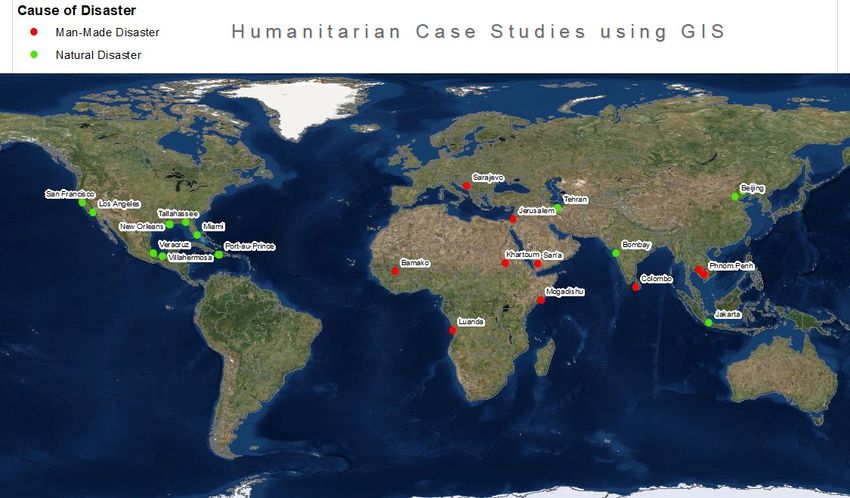
all studies). In regards to cause of disaster 35% of all studies explored man-made disasters
while 54% explored natural disasters. Figure 1. can help us visualize what types of disasters are
being studied and where. As we can see most humanitarian research caused by natural
disasters incorporating GIS is being conducted in the Americas and parts of South East Asia
while most Man-Made disasters are being studied in Africa and parts of the Middle East as well
which is an unfortunate observation.
Conclusion
This meta-analysis hopes to have revealed the broad range of tasks and challenges that can be
accomplished using geographic information systems in humanitarian settings, from quantifying
access to health care services by rural populations in Israel to using crowdsourcing data from
social media to optimize the location of shelters in Indonesia. This study also hopes to serve as
a valuable guide for future research in the field of geospatial information and humanitarian
assistance. It is interesting to note that while previous meta-analysis on humanitarian logistics
have analyzed over 150 articles (Kovács 2007, Kunz and Reiner, (2012) and while there existsPathways: A Journal of Humanistic and Social Inquiry, Vol.1, Iss. 2 (January 2020)
an abundance of studies incorporating GIS for environmental and disaster management, we see
that humanitarian aid research incorporating the use of geographic information systems has
relatively been neglected by the academic community. Furthermore, the earliest article found
using GIS exclusively in the area of humanitarian aid is that by Mather, C (2000). This shows
the relatively recent interest by the academic community which may be attributed to greater
computational power and software accessibility in recent decades. As Verjee points out “there
still remains a remarkable lack of doctrine in how to properly exploit geographic information
during humanitarian emergencies.” Furthermore, no geospatial vulnerability assessment studies
were found to have been conducted in Africa which stresses the need for reliable
socio-economic data in such region. Multiple studies unfortunately predict natural and
man-made disasters are likely to increase over the next 50 years and without greater interest by
the academic community this may result in a shortage of properly trained personnel capable of
fully utilizing geospatial techniques in humanitarian settings. As Bernhardsen (2002) notes that
“we should hope that based on our awareness of GIS’s roots and capabilities, we can be
realistic about our potential to foresee (model) and forestall (manage) human affairs on a global
basis.”
References:
Bernhardsen, Tor; Geographic Information Systems: An Introduction. New York, John Wiley &
Sons, 2002. Print
Cutter, S. L. (2003), GI Science, Disasters, and Emergency Management. Transactions in GIS,
7: 439-446.
De la Torre, Luis E., et al. “Disaster Relief Routing: Integrating Research and Practice.”
Socio-Economic Planning Sciences, vol. 46, no. 1, Mar. 2012, pp. 88–97.
Gyöngyi Kovács, Karen M. Spens, (2007) "Humanitarian logistics in disaster relief operations",
International Journal of Physical Distribution & Logistics Management, Vol. 37 Issue: 2,
pp.99-114.
Hannes Seppänen & Kirsi Virrantaus (2010) The role of GI-supported methods in crisis
management, International Journal of Digital Earth, 3:4, 340-354.
Kaiser, Reinhard, et al. "The Application of Geographic Information Systems and Global
Positioning Systems in Humanitarian Emergencies: Lessons Learned, Programme
Implications and Future Research." Disasters, vol. 27, no. 2, June 2003, pp. 127-140.
Longley, Paul A, Goodchild, Michael F, Maguire, David J. Rhind, David. Geographic Information
Systems and Science. John Wiley & Sons (2005) Print.
Nathan Kunz, Gerald Reiner, (2012) "A meta-analysis of humanitarian logistics research",
Journal of Humanitarian Logistics and Supply Chain Management, Vol. 2 Issue: 2,
pp.116-147
Olsen, Gorm Rye, et al. “Humanitarian Crises: What Determines the Level of Emergency
Assistance? Media Coverage, Donor Interests and the Aid Business.” Disasters, vol. 27,
no. 2, June 2003, pp. 109–126Pathways: A Journal of Humanistic and Social Inquiry, Vol.1, Iss. 2 (January 2020)
Özdamar, Linet; Mustafa Alp Ertem. Models, solutions and enabling technologies in
humanitarian logistics. European Journal of Operational Research, Vol: 244, Issue: 1,
Page: 55-65 (2015).
The sphere handbook: Humanitarian charter and minimum standards in humanitarian response.
Sphere. 2018.
Tunca Tabaklar, Árni Halldórsson, Gyöngyi Kovács, Karen Spens, (2015) "Borrowing theories in
humanitarian supply chain management", Journal of Humanitarian Logistics and Supply
Chain Management, Vol. 5 Issue: 3, pp.281-299 (Interdiciplinary- HumLog)
Van Wassenhove, L. N. “Humanitarian Aid Logistics: Supply Chain Management in High Gear.”
The Journal of the Operational Research Society, vol. 57, no. 5, 2006, pp. 475–489
Verjee, Firoz: The Application of Geomatics in Complex Humanitarian Emergencies (2005).
(Unpublished Article) Institute for Crisis, Disaster & Risk Management; The George
Washington University.
Young, E. (2012). Food and Development. London: Routledge
Bibliography For Humanitarian Geospatial Articles
Ahmadi, Morteza, et al. "A Humanitarian Logistics Model for Disaster Relief Operation
Considering Network Failure and Standard Relief Time: A Case Study on San Francisco
District." Transportation Research: Part E, vol. 75, Mar. 2015, pp. 145-163.
Benini, Aldo A., et al. "Integration of Different Data Bodies for Humanitarian Decision Support:
An Example from Mine Action." Disasters, vol. 27, no. 4, Dec. 2003, pp. 288-304.
Bhanumurthy, V., et al. “Defining a Framework for Integration of Geospatial Technologies for
Emergency Management.” Geocarto International, vol. 30, no. 9, Oct. 2015, pp.
963–983.
Bono, Flavio, and Eugenio Gutiérrez. “A Network-Based Analysis of the Impact of Structural
Damage on Urban Accessibility Following a Disaster: The Case of the Seismically
Damaged Port Au Prince and Carrefour Urban Road Networks.” Journal of Transport
Geography, vol. 19, no. 6, Nov. 2011, pp. 1443–1455.
Chen, Zhifen, et al. "The Temporal Hierarchy of Shelters: A Hierarchical Location Model for
Earthquake-Shelter Planning." International Journal of Geographical Information
Science, vol. 27, no. 8, Aug. 2013, pp. 1612-1630.
Crooks, Andrew T. and Sarah Wise. "GIS and Agent-Based Models for Humanitarian
Assistance." Computers, Environment & Urban Systems, vol. 41, Sept. 2013, pp.
100-111.
Eklund, L., & Mårtensson, U. (2012). Using geographical information systems to analyse
accessibility to health services in the west bank, occupied palestinian Territory. Eastern
Mediterranean Health Journal, 18(8), 796-802.Pathways: A Journal of Humanistic and Social Inquiry, Vol.1, Iss. 2 (January 2020)
Elliott, James R. and Jeremy Pais. "When Nature Pushes Back: Environmental Impact and the
Spatial Redistribution of Socially Vulnerable Populations." Social Science Quarterly
(Wiley-Blackwell), vol. 91, no. 5, 15 Dec. 2010, pp. 1187-1202.
Enders, Alexandra, and Zachary Brandt. “Using Geographic Information System Technology to
Improve Emergency Management and Disaster Response for People With Disabilities.”
Journal of Disability Policy Studies, vol. 17, no. 4, Spring 2007, pp. 223–229.
Esmaelian, Majid, et al. “A Multicriteria Spatial Decision Support System for Solving Emergency
Service Station Location Problems.” International Journal of Geographical Information
Science, vol. 29, no. 7, July 2015, pp. 1187–1213.
Horner, Mark W. and Joni A. Downs. "Optimizing Hurricane Disaster Relief Goods Distribution:
Model Development and Application with Respect to Planning Strategies." Disasters, vol.
34, no. 3, July 2010, pp. 821-844.
Kandeh, Joseph and Lalit Kumar. "Developing a Relative Ranking of Social Vulnerability of
Governorates of Yemen to Humanitarian Crisis." ISPRS International Journal of
Geo-Information, vol. 4, no. 4, Dec. 2015, pp. 1913-1935.
Karen Payne, Patrick Florance & Stephen Shain (2012) The Role of Data Repositories in
Humanitarian Information Management and Crisis Mapping, Journal of Map &
Geography Libraries, 8:2, 118-133.
Kusumo, A. N. L., et al. “Utilising Volunteered Geographic Information to Assess Resident’s
Flood Evacuation Shelters. Case Study: Jakarta.” Applied Geography, vol. 88, Nov.
2017, pp. 174–185
Lue, Evan and John P. Wilson. "Mapping Fires and American Red Cross Aid Using
Demographic Indicators of Vulnerability." Disasters, vol. 41, no. 2, Apr. 2017, pp.
409-426. EBSCOhost, doi:10.1111/disa.12198
Marx, A., & Goward, S. (2013). REMOTE SENSING IN HUMAN RIGHTS AND
INTERNATIONAL HUMANITARIAN LAW MONITORING: CONCEPTS AND
METHODdagger]. Geographical Review, 103(1), 100-111.
Mather, C. "Geographical Information Systems and Humanitarian Demining." South African
Geographical Journal, vol. 82, no. 1, Apr. 2000, p. 56.
Porto de Albuquerque, João, et al. "The Tasks of the Crowd: A Typology of Tasks in Geographic
Information Crowdsourcing and a Case Study in Humanitarian Mapping." Remote
Sensing, vol. 8, no. 10, Oct. 2016, pp. 1-22.
Rodríguez-Espíndola, Oscar, et al. "GIS and Optimisation: Potential Benefits for Emergency
Facility Location in Humanitarian Logistics." Geosciences (2076-3263), vol. 6, no. 2,
June 2016, pp. 1-34.Pathways: A Journal of Humanistic and Social Inquiry, Vol.1, Iss. 2 (January 2020)
Seppänen, Hannes and Kirsi Virrantaus. "The Role of GI-Supported Methods in Crisis
Management." International Journal of Digital Earth, vol. 3, no. 4, Dec. 2010, pp.
340-354.
Sheller, Mimi. "The Islanding Effect: Post-Disaster Mobility Systems and Humanitarian Logistics
in Haiti." Cultural Geographies, vol. 20, no. 2, Apr. 2013, pp. 185-204.
Sherly, Mazhuvanchery Avarachen, et al. “Disaster Vulnerability Mapping for a Densely
Populated Coastal Urban Area: An Application to Mumbai, India.” Annals of the
Association of American Geographers, vol. 105, no. 6, Nov. 2015, pp. 1198–1220.
Shortland, Anja, et al. “War and Famine, Peace and Light? The Economic Dynamics of Conflict
in Somalia 1993–2009.” Journal of Peace Research, vol. 50, no. 5, Sept. 2013, pp.
545–561.
Taylor, O., & Slaymaker, O. (2005). Toward modeling regionally specific human security using
GIS: Case study cambodia. Ambio, 34(6), 445-9.
Tunçalp, Özge, et al. "Conflict, Displacement and Sexual and Reproductive Health Services in
Mali: Analysis of 2013 Health Resources Availability Mapping System (Herams) Survey."
Conflict & Health, vol. 9, no. 1, 14 Sept. 2015, pp. 1-9.
Williams, Craig and Christine E Dunn. "GIS in Participatory Research: Assessing the Impact of
Landmines on Communities in North-West Cambodia." Transactions in GIS, vol. 7, no.
3, June 2003, pp. 393-410
Zhao, Ming and Xiang Liu. "Development of Decision Support Tool for Optimizing Urban
Emergency Rescue Facility Locations to Improve Humanitarian Logistics Management."
Safety Science, vol. 102, Feb. 2018, pp. 110-117.
About the author:
David Ortiz was born in Medellin, Colombia and immigrated to the U.S at the early age of seven.
He is currently a Ph.D. Geography student at Florida International University and a graduate
teaching assistant. He earned his B.A in geography from Florida International as well and was
recipient of the 2019 School of International and Public Affairs academic excellence award in
geography and the 2016 Broward College discipline award in geography. His research interests
encompass urban studies, housing, data analysis and geographic information system (GIS).
Being highly passionate about both applied as well as critical social science research he wishes
to share such integrative approach with future students in order to make sense of complex and
ever changing urban societies. Off campus he practices beekeeping and plays the cuatro.You can also read