Lone Star College, Cy-Fair - November 9, 2012 9am-4pm Exhibitors
←
→
Page content transcription
If your browser does not render page correctly, please read the page content below
Sponsors:
Exhibitors: November 9, 2012
9am-4pm
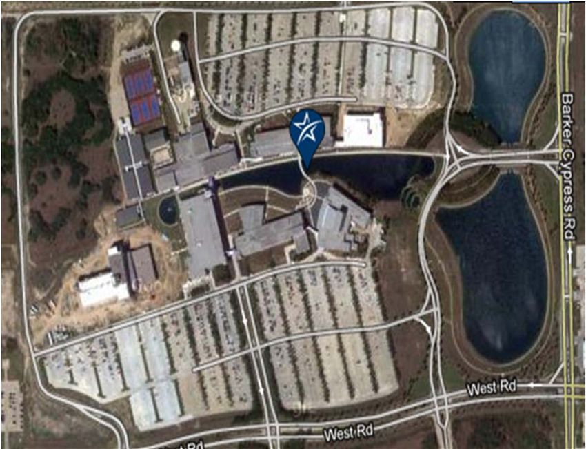
Lone Star College, Cy-Fair
9191 Barker Cypress Road
Cypress, TX 77433
College Center Building
www.HoustonAreaGISDay.org
Table of Contents

Schedule of Events and Speaker Presentations               Page 2                             Special Thanks to our 2012 GIS Day Planning Committee
Exhibitor List and Profiles                                Page 3-9                                           and Their Organizations
Campus Map                                                 Page 10-11
Student Day Schedule                                       Page 13                     Allison Alford, Western Data       Kim Ricker, Rice University
Sponsor Acknowledgement                                    Page 14-15                  Systems
Biography of Keynote Speaker                               Page 16                     Ashok Wadwani, Applied Field       Larry Nierth, City of Houston,
Map Gallery, Scholarship Opportunities, What is GIS?       Page 17                     Data Systems                       P&D
Mobile Unit, Geocaching, Computer Lab, Poster Sponsors     Page 18
GIS Committee Members Acknowledgement                      Page 19                     David Moss, HCAD                   Lori Kircher, City of Houston,
        Schedule of Events on November 9, 2012 – Lone Star College Cy-Fair             GIS Day, Chair                     PWE

 9:00am – 9:15 am                Welcome & Introductions, Recognition of Dignitaries   Grant Garrison, Port of Houston    Mandy Lu, City of Houston,
 ART Center, Auditorium          David Moss, HCAD                                      Authority                          PWE-PUD
  9:15 a.m. - 9:20 a.m.          Opening Address and Remarks
                                                                                                                          Maria Vera, Houston TranStar
                                 Dean Glenda Arnold Lone Star College Cy-Fair

  9:20 a.m. - 10:00 a.m.         Keynote Speaker: Sean Maday, Geospatial Engineer,     Jean Niswonger, Rice University    Melvic Degracia, Harris County
                                 Google - Art Center, Auditorium                                                          PID
                                                                                       Holly McDonald, Harris County      Nicholas Popovich, ESRI
 10:00 a.m. - 4:00 p.m.         Exhibit Hall and Map Gallery Open in College Center
                                                                                       Appraisal District
                                 Speaker Presentations
 10:15 a.m. - 10:45 a.m.         “Good GIS needs good Geodesy! Lessons Learned.”       Michael Goh, City of Houston-      Noel Estwick, Prairie View A&M
 College Center-RM151            Michael Barnes, APSG                                  PUD

 11:00 a.m. - 11:30 a.m.         “Mapping a Path towards Regional Tourism: The         Jeremy Scott, Texas Department     Robert LaBarbera, Houston-
 College Center-RM151            American Model”, Dr. Darrell McDonald, Stephen F.     of Transportation                  Galveston Area Council
                                 Austin State University
                                                                                       Jackie Smith, City of Houston      Scott Lamon, Harris County
 11:30 a.m. - 12:00 p.m.        “GIS Applied to Environmental Crime Enforcement”,
 College Center-RM 151          Dr. Jack Hill, Sam Houston State University                                               Flood Control District
                                                                                       Vince Hamilton, JACOBS
 12:00 p.m. - 1:00 p.m.          Student Lunch Break - ART Center, Front Patio

 1:00 p.m. - 1:30 p.m.           "The Impact of the Houston Ship Channel on Property
 College Center-RM151            Values”, Errol Williams, HCAD

  1:30 p.m. - 2:00 p.m.          Students – Kids Closing Sessions
  ART Center, Auditorium

  2:30 p.m. - 3:00 p.m.          "NOWHERE….You Are!”
  College Center-RM151           Shane Diaz, Montgomery County 9-1-1 District

  3:00 p.m. - 3:30 p.m.          "An Integrated Geospatial Platform for Regional
  College Center-RM151           Planning” - Bill Bass, HGAC

  3:30 p.m. - 4:00 p.m.          “Mapping Houston’s Homeless”
  College Center-RM151           Edward Ruiz, Texas Southern University                                                                                 Page 19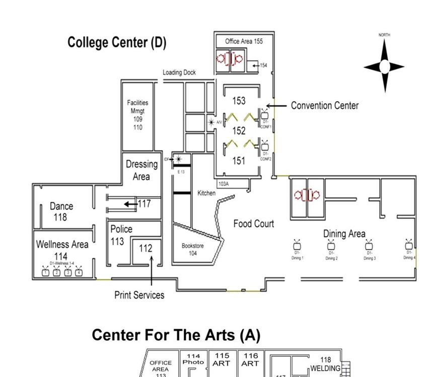
Profile
                                                    Booth                          Exhibitor Name
                 Mobile Unit Sponsors                                                                                          Page

                                                                             Applied Field Data Systems                          4

                                                                                         APSG                                    15

                                                                           City of Houston - GIS Services                        4

                                                                          City of Houston - PWE/PUD/BSB                          4

                                                                                         ESRI                                    5

                  Geocaching Sponsors                                      Harris County Appraisal District                      5

                                                              Harris County Flood Control District - Infrastructure GIS          5

                                                                   Harris County Information Technology Center                   6

                                                                      Houston-Galveston Area Council (HGAC)                      6

                                                                              KeyStone Aerial Surveys                            6

          GIS Student’s Day Computer Lab Sponsors                                  LJA Engineering                               7

                                                                              Lone Star College ,Cy-Fair                         7

                                                                                      Pictometry                                 7

                                                                                        SCAUG                                    8

                                                                                        Surdex                                   8
                  GIS Day Poster Designer
                                                                      Surveying and Mapping, Inc. (SAM, Inc.)                    8

                                                                   TSU - Urban Planning & Environmental Policy                   9

                                                                                Western Data Systems                             9

                                                     Registration / Information Booth located directly outside exhibit hall to left.

Page 18
                                                                                                                              Page 3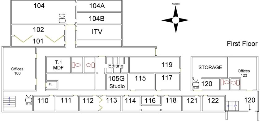
Exhibitor Profiles                                                                                              Map Gallery

                                                               Applied Field Data Systems, Inc.             Don’t forget to visit the map gallery located on the north side of the exhibit hall located in the
                                                                         16350 Park Ten Place,              convention center. Vote for your favorite printed or online map. Maps should showcase
                                                                  Suite 100, Houston, TX 77084              cartographic best practices. Emphasis will be on maps being visually stimulating and informative,
                                                                           Phone: 281.5790492               performance, content, and ease of use.
                                                Email: afdsaw@aol.com Website: www.afds.net

 Your source for: Gis services; Digitization, application development, consulting / training; Mapping
 systems; Gps receivers, laser range finders, gps enabled camera, field data collection software,
 rugged handheld pda, tablet computers, locators/markers
                                                                                                                                    Scholarship Opportunities

                                                                                                              The Houston-Galveston Area Council Geographic Data Studies Scholarship has been established
                                                         City of Houston Planning & Development               by the Houston-Galveston Area Council’s Geographic Data Committee in association with the 2012
                                                     611 Walker St., 6th Floor, Houston, TX 77002             GIS Day event. This $500 scholarship is intended for high school and college students pursuing a
                                                         GIS Services Help Desk: (713)837-7777                higher education degree in geographic studies or completing coursework in GIS or geography.
                                                                                Fax: (713)837-7716            This scholarship focuses on the continued learning and application of geographic information
                                                                                                              systems (GIS), and hopes to enhance a student’s college career and assist them with training for
  The Planning & Development Department maintains and operates the City of Houston Geographic                 future employment. The 2nd place winner will receive a GPS Garmin unit.
  Information System (COHGIS). COHGIS staff utilize data provided by Federal, State, County and
  local government entities to produce data sets that are distributed and used by other GIS
  operations, both public and private, within this region. The department is also leading an initiative
  to create an Enterprise GIS Service, focused on bridging access to the City's various data
  resources through data standards, enterprise database technology, Web portal services and new
  applications development. A core team of GIS analysts and developers is currently undertaking
  this exciting challenge.                                                                                                                    What is “GIS?”

                                                                                    City of Houston
                                                                                                              "In the strictest sense, a GIS is a computer system capable of assembling, storing, manipulating,
                                                      Department of Public Works and Engineering
                                                                                                              and displaying geographically referenced information, i.e. data identified according to their
                                                                    Public Utilities Division (PUD)
                                                                                                              locations. Practitioners also regard the total GIS as including operating personnel and the data that
                                                          Business Services Branch - GIS Services
                                                                                                              go into the system." USGS
                                                                   611 Walker, Houston, TX 77002
                                          http://www.publicworks.houstontx.gov/utilities/index.html
                                                                                                              "A geographic information system (GIS) is a computer-based tool for mapping and analyzing things
   The GIS Services Group is comprised of a Data Management Section and an Applications Section.
                                                                                                              that exist and events that happen on earth. GIS technology integrates common database
   The Data Management Section creates and maintains geospatial data for the City's water distribution
                                                                                                              operations such as query and statistical analysis with the unique visualization and geographic
   and wastewater collection systems. The Applications Section focuses on data analysis and the
                                                                                                              analysis benefits offered by maps." ESRI
   implementation of GIS technology and its capabilities. Drinking Water and Wastewater Operations
   use GIS technology to develop preventive maintenance schedules and design facility master plans
   that help support the division’s operating budgets. Availability of the data and data mapping supports
                                                                                                              "GIS is an integrated system of computer hardware, software, and trained personnel linking
   decision-making regarding the maintenance and planning of infrastructure facilities. GIS Services
                                                                                                              topographic, demographic, utility, facility, image and other resource data that is geographically
   also provides mapping documents for work order job tracking, density maps to analyze specific
                                                                                                              referenced." NASA
   problems, proximity maps to study the impact of infrastructure alignment, and identifies specific
   infrastructure components, such as community sewers and service connections.

Page 4                                                                                                                                                                                                     Page 17
Keynote Speaker                                                        Exhibitor Profiles

              Keynote Speaker: Sean Maday,          Esri Houston Satellite Office
              Geospatial Engineer at Google         11200 Westheimer, Suite 630
                                                    Houston, TX 77042
                                                    p: 713.401.0658 f: 713.782.5958
                                                    www.esri.com

                                                    Esri’s geographic information system (GIS) software has given clients the power to think and plan
                                                    geographically for over 40 years and is used in more than 300,000 organizations worldwide. GIS
                                                    helps cities, governments, universities, and Fortune 500 companies save money, lives, and our
                                                    environment. From transporting ethanol to studying landslides, GIS combines hardware, software,
                                                    and data to collect, manage, and analyze geographic information, which helps people view
                                                    relationships, patterns, and trends. Solve problems and make better decisions by looking at your
                                                    valuable     data    in   a    way   that   is   quickly   understood     and   easily    shared.

                                                    Harris County Appraisal District
                                                    13013 Northwest Freeway, Houston, TX 77040
                                                    Office: 713-957-7489 Fax: 713-957-7489
                                                    www.hcad.org
          Sean Maday served as a U.S. Air Force
          Intelligence Officer from 2005 to 2010,   The Harris County Appraisal District, a political subdivision of the State of Texas, is responsible
          and formerly worked for a research and    for local property tax appraisal and exemption administration for nearly 640 jurisdictions (taxing
                                                    units) in America's third most populous county. Over 1.3 million property parcels are located in
          development lab at the U.S. Air Force
                                                    our service area and consequently in our GIS database. The GIS at HCAD, since its inception
          Academy. He holds a bachelor’s and        in 1993, has become a critical tool used daily by HCAD staff. The result of our GIS, detailed
          master’s degree from Michigan State       and accurate maps and data, have become the staple for local taxing units and government
          University                                agencies, property owners and private industry alike.

                                                    Harris County Flood Control District
                                                    9900 Northwest Freeway, Houston, TX 77092
                                                    Office: 713-684-4000 Fax: 713-684-4140
                                                    www.hcfcd.org

                                                    The Harris County Flood Control District is a special purpose district created by the State
                                                    legislature in 1937 in response to devastating floods that struck the region in 1929 and 1935. The
                                                    District's boundaries are coincident with Harris County, and the Harris County Commissioners
                                                    Court serves as our "board of directors" to provide our elected representation. In June 1998, the
                                                    District became part of the new Harris County Public Infrastructure Department, although the
                                                    Harris County Flood Control District remains a separate legal entity and retains its public identity.
                                                    The District will be working with the Public Infrastructure Department to identify opportunities for
                                                    improved coordination and efficiency with its other divisions. The Flood Control District's mission
                                                    in simple terms is to: devise the flood damage reduction plan; implement the plan; and, maintain
                                                    the infrastructure.

                                                                                                                                                      Page 5
Page 16
Exhibitor Profiles                                                                               Sponsor Acknowledgement

                                         Harris County Information Technology Center (ITC)
                                       Architecture Team, Front Office Applications/GIS and
                                          The Spatial Services Committee for Harris County
                                              1310 Prairie Suite 1501, Houston Texas, 77002
                                                                               713-368-0006

Harris County Information Technology Center (ITC) delivers high quality, innovative, and cost        CenterPoint Energy operates in five primary businesses: electric transmission and distribution,
effective information technology solutions for the agencies and citizens of Harris County. ITC       natural gas distribution, interstate natural gas pipelines, field services, and competitive natural
maintains the County’s technology, application, and data infrastructure and works to increase        gas sales and services. The energy we deliver is at the center of our customers' lives: from 24-
application availability and asset life while minimizing costs. ITC partners with its supported      hour a-day television broadcasts … to gourmet gas kitchens … to comfortable gas heating … to
agencies by evaluating emerging technologies, providing recommendations for cost-effective           handheld computers and cellular phone connections.
automation opportunities, and implementing solutions that meet their needs. A core component
of ITC is the GIS Services team. This team is responsible for administering a central repository     CenterPoint Energy is a company of people who are "always there."
for common GIS data in use throughout the county. The team develops and maintains mapping
services in support of ITC software applications, and it provides GIS services and geospatial
products to agencies and citizens of Harris County.

                                    Houston-Galveston Area Council (H-GAC) Data Services
                                            3555 Timmons Lane, Suite 120, P.O. Box 2277
                                                                      Houston, TX 77027              Founded in 1945, Dannenbaum Engineering is a long term success story. Proof of our staying
                                                 Office: 713-627-3200 Fax: 713-993-2481              power is evident both in the enduring relationships we build with our clients and in the long-lived
                                                                        www.h-gac.com                projects we help them construct. Over 60 years we’ve seen markets shift, client expectations
                                                                                                     expand and technology evolve in astounding ways. Yet through it all, our framework has
The Houston-Galveston Area Council (H-GAC) is a voluntary association of local governments           remained stable and our strategy has never wavered. By combining depth of experience with
and local elected officials in the 13-county Gulf Coast Planning Region, an area of 12,500           forward-thinking solutions. Dannenbaum is helping clients achieve their goals and expectations.
square miles with over 5 million people. Local elected officials organized H-GAC in 1966 after
authorization by State enabling legislation. H-GAC now has 132 local government members,
including all major general-purpose local governments in the 13-county region: 13 counties, 105
cities, 14 school districts. H-GAC gives highest priority to serving local government needs to
help them plan for tomorrow. It promotes voluntary approaches in region-wide purchasing, solid
waste management, air and water quality, workforce development, criminal justice system
improvements and law enforcement officer training, transportation system improvement                 The Houston TranStar consortium is a partnership of the Texas Department of Transportation,
planning, 9-1-1 emergency communications, services to senior citizens, and other significant         Harris County, the Metropolitan Transit Authority, and the City of Houston. It is responsible for
areas of concern to local government.                                                                providing transportation management and emergency management services to the greater
                                                                                                     Houston region. TranStar uses state of the art technologies to reduce congestion on major
                                                                      Keystone Aerial Surveys        roadways. When emergency conditions arise such as hurricanes, etc., the emergency
                                                                  209 Airport Drive, Hangar #4       operations center (EOC) at the center is activated. Emergency management activities and
                                                                               Tyler, TX 75709       warnings have decreased the number of injuries, deaths, and extensive property damage
                                                                          Phone: 903.600.1310        caused     by    floods   and     other    weather-related      and/or    man-made       events.
                                                             http://keystoneaerialsurveys.com        www.HoustonTranStar.org

 Keystone operates with a fleet of nearly 20 survey aircraft, equipped with flight management
 systems, stabilized mounts, GPS, with film, digital, lidar and magnetometer sensor capabilities.
 Keystone operates an Optech Gemini sensor, delivering accurate and detailed height data to
 our partners and clients. Keystone’s many aircraft, excellent pilots and operators along with our
 experienced maintenance and technical teams provide a flexible and stable platform for any
 sensor or sensor package. As one of the newest DG resellers, we offer worldwide satellite
                                                                                                     Jacobs Engineering Group is a global company with over 56,000 employees of which over
 imagery and recent aerial imagery of the US. The Precision Aerial program offers 30cm RGB
                                                                                                     2,000 are based in the Houston, Texas office. The Jacobs technical expertise includes Building
 and 60cm CIR of the entire US from 2011-2012. Keystone offers selected derived products to
                                                                                                     Information Modeling (BIM), Application development and all facets of GIS implementation from
 its clients and partners that want to use the processing power of Keystone to speed their
                                                                                                     planning through enterprise deployment and onsite support. Contact Vince Hamilton at 832-
 delivery times, limit their costs or to just add more value to what they deliver.
                                                                                                     405-9764 for more information related to Jacobs services.

Page 6                                                                                                                                                                                         Page 15
Exhibitor Profiles
Sponsor Acknowledgement
Thank you very much to our sponsors, without whose generous contributions GIS Day would not
be possible. LJA Engineering, Inc.
2929 Briarpark Drive, Suite 600, Houston, TX 77042
Office: 713-953-5200 Fax: 713-953-5026
www.ljaengineering.com
LJA Engineering, Inc. is an employee-owned, consulting engineering firm with full in-house
capabilities to provide comprehensive professional engineering services to public and private
sectors—both locally and internationally. Our staff includes over 250 experienced civil,
transportation, coastal/waterfront, structural and rail engineers, hydrologists, environmental
Among the largest independent oil and natural gas exploration and production companies in the specialists, land planners, landscape architects, construction managers, designers, GIS
world, with 2.4 billion barrels of oil equivalent (BBOE) of proved reserves at year-end 2010. specialists, technicians, and surveyors. LJA’s strongest asset is our reputation for providing
At Anadarko, we are committed to safely producing the energy we all need in a manner that quality services in a timely manner. Our staff of experienced engineers and technicians
protect the environment, public health and supports our communities. Energy is fundamental to understand client needs and are committed to developing creative, innovative and responsive
physical existence. It is as important as clean air, water and affordable food. We take our solutions to a wide range of project challenges. LJA is located in Texas with offices in Houston,
responsibility seriously to deliver resources to our energy-hungry world, and we hold true to our Austin, San Antonio, Beaumont, Galveston, and The Woodlands.
core values of integrity and trust, servant leadership, commercial focus, people and passion, and
open communication in all of our business activities.
Lone Star College, Cy-Fair/ Fairbanks Center
9191 Barker Cypress, CENT 155-E
Cypress, TX 77433
LoneStar.edu/cyfair
Lone Star College-CyFair: Something for Everyone
Serving approximately 20,000 students, Lone Star College-CyFair offers options, flexibility and
affordability with day, evening, online, Friday only and Weekend College courses. Students can
The Virginia and Andre Bally GIS Study Scholarship, established by the Bally family, awards choose from a wide range of associate degrees, workforce certificates, university transfer courses
$500 to a Houston area high school student that wins the GIS Day Essay Competition. and continuing education courses. LSC-CyFair’s facilities, programs and services are designed to
provide a successful learning experience that prepares students for the rapidly changing workforce
and for a lifetime of learning and change. There are two convenient locations to serve the
community: the Barker Cypress campus set on 200+ acres at 9191 Barker Cypress at West Road
and the full-service satellite LSC-Fairbanks Center at 14955 Northwest Freeway near Beltway 8. Visit
LoneStar.edu for information..
Pictometry
100 Town Centre Drive, Suite A, Rochester, NY 14623
Founded in November 1998, the Americas Petroleum Survey Group (APSG) is an unincorporated 1.888.771.9714 Toll Free
association of individuals. Members include experts in geomatics, surveying, positioning, www.pictometry.com
geospatial data management, and mapping sciences from E&P companies, oilfield service
companies, survey contractors, consultants, and academia. Check out the impressive mix of Seeing Solutions Starts with Pictometry® imagery. Pictometry has taken the elusiveness out of
companies at our Public Member Directory. “getting ‘the big picture’”. Now, everyone can ‘get it’ – and see solutions at every turn. By blending
our highest quality, patented aerial oblique imagery with information that matters most to you, we
APSG is well regarded for its industry leadership, educational programs, and professional can serve up solutions as you need them – within existing systems, in a do-it-yourself application,
networking. or even in a complete report. Pictometry is a comprehensive, customizable image-based solution
infused with analytic and reporting capabilities you never thought possible. Put the world’s most
comprehensive continually-updated oblique image library at your fingertips and give your decision
making the confidence it needs. Imagery infused with Data and blended with Integration and
Reporting capabilities equals Pictometry Solutions.
Page 14 Page 7Exhibitor Profiles Student Day Schedule
Student Schedule: Group A-Yellow, Group B-Green, Group C-Blue, Group D-Pink
SCAUG, South Central Arc Users Group Campus Police: 281-290-5911
www.scaug.org 8:45-9:00 9:00-10:00 10:05 - 10:45 - 11:25 – 12:05 - 12:50 - 1:30 - 2:00
am am 10:40 am 11:20 am 12:00 pm 12:45 pm 1:25 pm pm
Arrival, Group,
and Escort to
Auditorium ABCD
Since 1990, the South Central Arc User Group (SCAUG) has provided resources and tools for Opening
Geographic Information Systems (GIS) users and professionals in Texas, Oklahoma, Louisiana Ceremonies –
Arts Building -
and Mississippi. If your organization is currently using or is planning to implement GIS in the future
Auditorium ABCD
you can benefit from becoming a member of SCAUG. Membership connects you to a community
GPS Tools &
of knowledgeable professionals in a growing industry. SCAUG has over a 1000 active members Applications
and continues to grow. Presentation –
Arts
Auditorium A B C D
Video
Presentation-
Surdex Corporation Arts Building
25622 Creston Meadow Drive RM 102 B A D C
Richmond, TX 77406
Geocaching
Tel: 281.232.4749
Session-
Fax: 281.232.4329 Outside Arts Selected 5 Selected 5 Selected 5 Selected 5
Building from A from B from C from D
Surdex has been recognized as a premier geospatial data provider since 1954, supplying Internet Lab A
accurate and precise information—on time and within budget—to a diverse client base. Our – Tech Center
success can be attributed to our focus on client satisfaction through timely delivery of quality – RM 103 C1 D1 A1 B1
products and continuous innovation from our investment in staff and equipment resources. Internet Lab B
Surdex provides orthophotography; planimetric and topographic maps; LiDAR and hydrographic – Tech Center
mapping as well as data hosting services. A distinguisher for Surdex is our commitment to – RM 110 C2 D2 A2 B2
helping clients achieve their goals and objectives. We have a highly-trained and experienced Internet Lab C
– Tech Center
staff that provides complete geographic solutions customized to client needs and expectations.
– RM 114 C3 D3 A3 B3
Mobile Units – D – 25 Min C – 25 Min B – 25 Min A – 25 Min
Outside (10:05 – (10:45 – (11:25 – (12:50 –
Library 10:30) 11:10) 11:50) 1:15)
Exhibits –
College Center D- 10 Min C- 10 Min B- 10 Min A - 10 Min
- RM 152 & (10:30- (11:10- (11:50- (1:15-
Surveying + Aerial Mapping + Engineering, (SAM), Inc. 153 10:40) 11:20) 12:00) 1:25)
11111 Katy Freeway, Suite 200 Lunch –
Houston, TX 77079 Outside Art
Tel: 713.973.5100 Building ABCD
www.saminc.biz Closing
Ceremonies
Founded in 1994, SAM, Inc. is a leader in providing complete geospatial solutions. SAM, Inc.’s Arts
‘complete geospatial’ approach gives us the tools and skills to develop efficient and customized Auditorium ABCD
solutions for projects of any scale. This gives our clients the benefit of a single point of contact
for a comprehensive set of surveying and mapping products.
SAM, In. offers Geographic Information Systems (GIS) services that complement our core
surveying, mapping, data acquisition, and management capabilities.
As an ESRI Business Partner, we provide complete turnkey solutions for project planning,
management, and implementation services. Both public and private sector clients depend on us
to provide high quality, accurate information required for planning purposes.
..
Page 8 Page 13Notes Exhibitor Profiles
Texas Southern University
3301 Cleburne, Houston Texas
Urban Planning & Environmental Policy
Program Recruiting Desk: 713-313-4836
TSU established its first Masters of City Planning program in the 1970’s. In 2003, a reconstituted
program Urban Planning & Environmental Policy continued the tradition of offering geographic
Information systems classes as a staple. TSU have been a licensed user of ESRI GIS programs
since 1988 with the advent of ArcInfo 1.0. Currently students are trained using all aspects of the
ArcInfo platform. The program offers both a Masters in Urban Planning & Environmental Policy
(MUPEP) and a PhD. The Masters program has four concentrations with Geographic Information
Systems using ESRI state of the art ArcInfo programs utilized in all concentrations. We are
committed in staying relevant in all aspects of our urban environment by utilizing the best faculty,
resources, and systems to foster competent graduates’ that can take the call from day one.
Western Data Systems
14722 Regnal
Houston, TX 77039
Office: 281-987-1815 Toll Free: 281-897-1815
www.westerndatasystems.com
Western Data Systems is an authorized Trimble dealer specializing in the sales, rental, training
and service/repair of Trimble GPS and Optical Land surveying, Mapping, Marine and
Page 12products. With offices in Houston, Dallas, San Antonio, Austin, Oklahoma City and
Construction
Pharr you are never far away from the experts.
Page 12
Page 9Map Gallery
Exhibit Hall,
Mobile Units
151
103
110 114You can also read