Water crisis in the Inner Niger Delta (Mali) Causes, consequences, solutions - Altenburg & Wymenga
←
→
Page content transcription
If your browser does not render page correctly, please read the page content below

In cooperation with

Water crisis in the Inner Niger Delta (Mali)
Causes, consequences, solutions

                                      A&W-report 1832

                 Commissioned by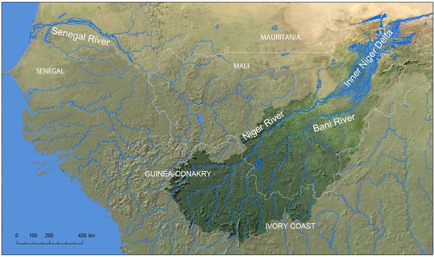
Water crisis in the Inner Niger Delta (Mali)
    Causes, consequences, solutions

    A&W-report 1832

    L. Zwarts
    J-L Frerotte

©   Altenburg & Wymenga ecologisch onderzoek bv
    Overname van gegevens uit dit rapport is toegestaan met bronvermelding.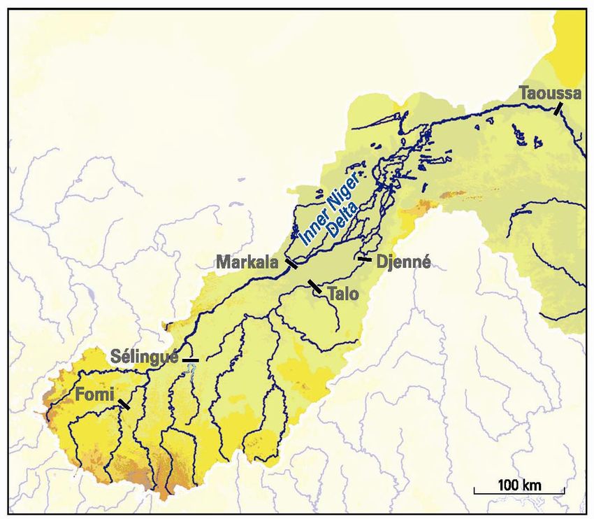
Photograph Cover
The Inner Niger Delta will turn into a dry savanna without flooding. , Photo: Leo Zwarts.

L. Zwarts, J-L Frerotte 2012
Water crisis in the Inner Niger Delta (Mali), Causes, consequences, solutions. A&W-report 1832
Altenburg & Wymenga ecologisch onderzoek, Feanwâlden

Commissioned by
CARE International
Juffrouw Idastraat 11
2513 BE 's Gravenhage
Telefoon 070 31 05 050

Commissioners
Altenburg & Wymenga                       Royal Haskoning
ecologisch onderzoek bv                   Postbus 151
Postbus 32                                6500 AD Nijmegen
9269 ZR Feanwâlden                        Telefoon 024 32 84 284
Telefoon 0511 47 47 64                    Fax 024 36 04 737
Fax 0511 47 27 40
info@altwym.nl
www.altwym.nl

Project number                             Project leader                             Status
1849min                                    E. Wymenga                                 Final report

Authorisation                              Signature                                  Date
Goedgekeurd                                E. Wymenga                                 24 September 2012
A&W-report 1832 Water crisis in the Inner Niger Delta (Mali)

Inhoud

   The Sahel: problems larger than life?                                             1
   The Niger River as lifeline in a dry world                                        1
   The Inner Niger Delta: a huge, green oasis in a dry Sahel                         1
   The river flow depends on the rainfall in the catchment area                      2
   The flooding of the Inner Delta depends on the inflow of Niger and Bani Rivers    2
   Year-to-year variation in the flooding of the Inner Niger Delta                   3
   Intervention in the Upper Niger: (1) Sélingué                                     4
   Intervention in the Upper Niger: (2) Markala                                      4
   Intervention in the Upper Niger: (3) Fomi                                         7
   Intervention in the Bani: (4) Talo                                                7
   Intervention in the Bani: (5) Djenné                                              7
   Intervention in the Niger downstream of the Inner Niger Delta: (6) Taoussa dam    8
   The interventions (will) reduce the flooding of the Inner Niger Delta             8
   Less flooding means less rice, less fish and less meat                           10
   BOX 1. Two persistent misconceptions about the impact downstream of dams         10
   Less flooding means a loss of biodiversity                                       11
   Mitigating the impact of a further loss of floodplains                           11
   Effective water management in the Upper Niger Basin                              12
   Hydropower is not worthwhile in dryland rivers                                   13
   Ten lessons learned                                                              13
   Appendix 1: reflections on Sahel AGIR                                            14
   Appendix 2: Reflections on EC Strategy Sahel                                     15
A&W-report 1832 Water crisis in the Inner Niger Delta (Mali)
A&W-report 1832 Water crisis in the Inner Niger Delta (Mali)   1

The Sahel: problems larger than life?
How to make a living where it is raining only a few months a year and – even worse– the
rainfall varies a lot between years? For the people in the Sahel, these variations are part of life:
they know how to survive, but this has become more difficult in the last decades. First of all, the
Sahel harbours twice as much people as 25 years ago and again a doubling of the population
is foreseen for the coming 20-25 years. To feed all mouths the food production must increase
by 3% a year. But how to enhance the production while the Sahel is plagued by long-lasting
drought periods of which the last one, known in West Africa as the Great Drought, lasted even
20 years (1972-1992). Although the rainfall has recovered since then, it is still poor compared
to the years before the Great Drought. On average, the rainfall in the Sahel has declined
annually by 0.3% over the last 150 years.
What will the future bring? The last years have been remarkably hot in the Sahel and the
climate models predict a further increase of the average temperature by 2-7°C in the next 80
years. Less certain are the climate models regarding the rainfall. None predicts an average
rainfall above the present low level and most suggest a decline of 20-40%.
Enough reasons to worry about the future.

The Niger River as lifeline in a dry world
The Sahel is the transition zone of about 500 km wide between the dry Sahara desert in the
north and a lush, green world of bushes and trees in the south, where the annual rainfall
exceeds 2000 mm. Most of this water drains directly into the ocean, but some rivers make a
lengthy detour inland. The Senegal and Niger River, both originating in Guinea-Conakry, run
initially north eastwards (Fig. 1). The Senegal then bends to the west, whereas the Niger make
a huge loop to the east, crossing the southern edge of the Sahara, before turning southward
towards Nigeria.
The Senegal and Niger Rivers are a lifeline for the communities living in the semi-arid, western
Sahel. Mali, a classic case of a river-dependent economy, faces the challenge how to exploit
this source of life. Dams and irrigation schemes may help increase economic independence
and food security in the unstable Sahel environment. Tapping the Niger’s flow, however, has
serious consequences downstream.

The Inner Niger Delta: a huge, green oasis in a dry Sahel
The Niger is a mighty river during the raining season in August and September, but in April, at
the end of the long, dry season, the flow is reduced to nearly nothing, being on average 80
times less than in the raining season. Without this large seasonal variation in river flow there
would be no Inner Niger Delta (Fig. 1), no annual flooding and deflooding of a huge area
between the old towns of Djenné and Mopti in the south and Timbuktu in the north. The flood
pulse of the Niger is like a wave rolling over a giant saucer transforming arid land into a vast
but temporary wetland. The large between-year differences in flooding make the system even
more dynamic. In a year with a high peak flood level in the Inner Delta, the flood lasts seven
months, four months longer than in a year with a low flood: the wave comes in a wet year one
month earlier and continues for an additional three months.
There are more riverine floodplains in the world, but the Inner Niger Delta is unique. Firstly, it is
huge covering an area of 400 by 100 km. Moreover, it is a green oasis in large contrast to the
dry surroundings. Last but not least, the flood height in the Inner Niger Delta may reach six
meter, whereas it is less than 2 or m at a maximum in most other African seasonal floodplains.
The Inner Niger Delta is a highly productive wetland which attracts 1,5 million people making a
living as fishermen, farmer and/or cattle breeder. The area also attracts during the northern
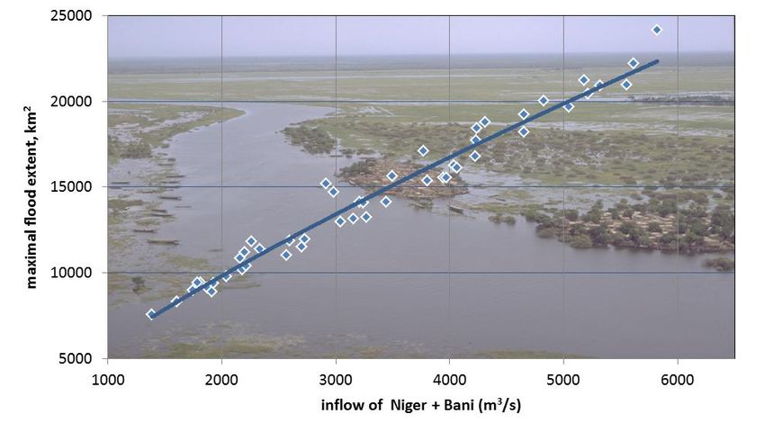
2    A&W-report 1832 Water crisis in the Inner Niger Delta (Mali)

winter millions of water birds originating from Europe and Asia, which was the reason to
designate in 2004 the entire floodplain area as a Ramsar Wetland Site of International
Importance, totally 41,195 km2 in surface.

Fig. 1. The Niger rises in the Guinean Highlands. The main tributary of the Niger is the Bani which drains SW Mali and
NE Ivory Coast. The flooding of the Inner Niger Delta is determined by the inflow from both rivers, which in turn relate
to the rainfall experienced 600-900 km away in the same year and the ground water table such as determined by the
rainfall during the preceding years.

The river flow depends on the rainfall in the catchment area
Local rainfall is too limited to have an effect on flood height in the Inner Niger Delta. Hence its
flooding is determined by the inflow from the Niger River and its main tributary, the Bani (Fig.
1). The inflow of both rivers in turn relate to the rainfall experienced 600-900 km SW of the
area. A comparison between rainfall and discharge in the Upper Niger basin reveals, however,
a large yearly variation in river flow and a much smaller variation in rainfall. The explanation
hinges on the cumulative effect of rainfall on river discharges: dry years lower the discharge,
but it takes a number of wet years to attain subsequently a high discharge. Hence river
discharges not only relate to rainfall in the preceding wet season, but to a large extent also to
earlier wet seasons. After a series of dry years, the discharge is insufficient to keep the
groundwater table at a certain level; in turn a low groundwater table increased infiltration of
surface water. The disappearance of river water as groundwater is especially pronounced in
the lower Bani, which lost 80% of its flow after a series of dry years.
A continuing decline of the river flow of the Niger and Bani is to be expected given the
anticipated climate change. As shown below, the inflow into the Inner Niger Delta will decrease
even more due to the planned interventions in the Upper Basin.

The flooding of the Inner Delta depends on the inflow of Niger and Bani Rivers
Topographical maps of the Inner Niger Delta show the floodplain as if it were flooded at a
maximum level, but the area actually inundated varies considerably between years (Fig. 2).
A&W-report 1832 Water crisis in the Inner Niger Delta (Mali)   3

Only a high river discharge produces a high flood. Since the mid-1950s, the average flow in
August-October for Bani and Niger has varied between 1850 and 7200 m3/s, equivalent to a
total seasonal flow of 14.7 and 57.2 km3 respectively. In 1984, the water level at the gauge of
Akka in the centre of the Inner Niger Delta just exceed 3 metres. In contrast, in 1957 and 1964,
the water level at Akka reached the very high level of more than 6 metres.

Fig. 2. The maximally flooded surface of the Inner Niger Delta within a year depends on the combined discharge of the
Niger and Bani at the entrance the Delta, averaged for August-October that year. Each dot is a year. The slightly
curved line gives the average relationship.

A high inflow not only produces a high flood level, but also floods a more extensive area.
Satellite images were used to produce water maps of the Inner Niger Delta covering the full
range of water levels. These water maps allow the determination of the relationship between
water level and the inundated area. Water maps were combined to construct a digital flooding
model. The maximum water level, usually reached in November, can be predicted reliably from
the average river flow in August, September and October combined for both rivers. A simple
equation also accurately predicts the size of the floodplains as a function of river flow (Fig. 2).

Year-to-year variation in the flooding of the Inner Niger Delta
In the disaster year 1984, the flooded area was limited to a mere 7800 km2 against 22,000 km2
in the good, old time before the Great Drought. It should be noted that this is still substantially
smaller than the total floodplain of 31,000 km2 as shown on the just mentioned topographical
maps. This apparent discrepancy is caused by the shallow northward slope of the floodplain
that delays flooding in the north with three months; by that time the southern floodplain has
already been drained of water. Because the remote sensing analysis is based on actual water
coverage, the area flooded at any one time is always less than the total area flooded in the
course of a year.
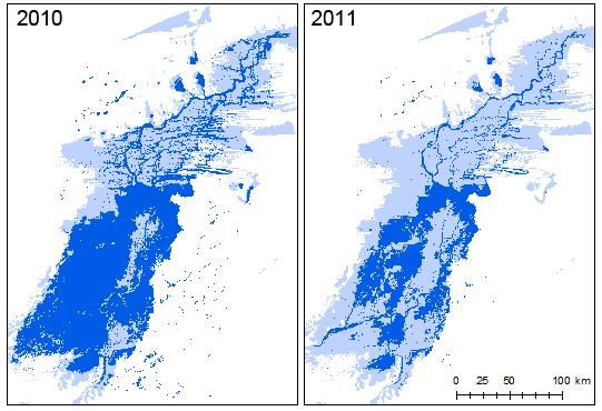
4    A&W-report 1832 Water crisis in the Inner Niger Delta (Mali)

Fig. 3. The flood extent (dark blue) of the Inner Niger Delta in two recent years, compared to the maximally inundated
zone (light blue; 31,000 km2). The flooding was quite normal in 2010, at least for the last 10-20 year (peak flood level
504 cm on the gauge of Akka and a flood extent of 15,900 km2), but relatively poor in 2011 (peak flood level 401 cm
and a flooded area of 10,000 km2).

Intervention in the Upper Niger: (1) Sélingué
Since 1982, the flow of the Upper Niger has not been fully natural due to the construction of the
Sélingué reservoir in the Sankarani tributary (Fig. 5). The Sélingué reservoir covers 450 km2
when full (2.1 km3). 1.8 km3 of the annual flow is withheld by Sélingué in August and
September, of which 0.5 km3 is lost due to evaporation. In the dry season 0.2 km3 per month is
released, as a consequence of which the (natural) river flow roughly doubles in these months.
The water stored annually in the reservoir amounts to 10-20% of the peak flow in wet years, but
to 20-30% in dry years.

Intervention in the Upper Niger: (2) Markala
The irrigation zone managed by Office du Niger is possible thanks to the Markala dam, a weir
across the river used to raise the water level 5.5 m above the lowest water level of the river
(Fig. 5). This enables irrigation under gravitation. The irrigation zone of Office du Niger is
located in the Delta mort, an ancient branch of the Niger. The Markala dam has been
operational since 1947, but it took many years before the irrigation scheme was developed.
A&W-report 1832 Water crisis in the Inner Niger Delta (Mali) 5
30000
maximal flood extent, km2
20000
10000
0
1920 1930 1940 1950 1960 1970 1980 1990 2000 2010
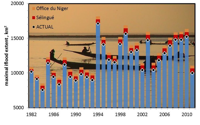
Fig. 4. The inundation of the Inner Niger Delta during the peak flood varies from year to year. 20,000 to 25,000 km2
was inundated in the wet 1950s and 1960s. The 60% decline in flooding between the 1960s and 1980s was due mainly
to a decrease of the river discharge of the Bani (down 80%) and the Niger (down 50%). The flood extent is larger again
since the mid-1990s, but still small compared to the past. The flood extent in 2011 was nearly as low as during the
disaster years in the 1980s.
The water intake amounts to 2.69 km3 per year, equivalent to 86.5 m3/s and does not differ for
dry or wet years. Despite the gradual extension of the irrigated zone, the total water extraction
remained at the same level between 1988 and 2011. Over the same period, the annual river
discharge at Markala varied between 539 and 1229 m3/s. As a consequence, water use by
Office du Niger is not more than 7% of a high river flow (1995), but this may increase to 16%
when the flow is low (1989). The monthly water use by Office du Niger varies seasonally and is
60 m3/s in January, gradually increasing to 130 m3/s in October, decreasing to 90 m3/s in
November and 50 m3/s in December. The available water supply varies between 100 m3/s in
March and 3200 m3/s in September. Hence 60% of the flow is tapped in March against only a
few per cent in September/October.6 A&W-report 1832 Water crisis in the Inner Niger Delta (Mali) Fig. 5. The Upper Niger Bassin. Sélingué, Markala and Talo are existing dams. Fomi, Djenné and Taoussa are still in study. The expansion of the Office du Niger so far has been able without an increase of the total water consumption in September – February, but the intended extension to 193,000 or even nearly 300,000 km2 in 2020 has only sense at a higher water intake. The water consumption in September and October amounts to 120-130 m3/s and has never been higher than 146 m3/s during a month. This limit is determined by the dimensions of the hydrological system. A bigger channel may enable Office du Niger to take more water and thus to extend the irrigation zone. However, this will only be possible in the period July-February, but not in March-July. In the present situation the river discharge sets a limit to the water consumption in March-July. During these months the water intake has increased the last 15 years by about 30%. A further increase is hardly possible, since the river discharge cannot be used completely for irrigation to avoid serious ecological and economic problems downstream of the Markala dam. The minimal required water flow passing the weir is set at 40 m3/s. During recent years, this lower limit is passed already between mid-March and mid-May. In conclusion, Office du Niger consumes at present 7% of the river water in a year with a high flow, but 16% in a year with a low flow. The seasonal variation is even larger, with 60% taken in March and a few per cent in October. Office du Niger has the ambition to grow but faces two constraints: the capacity of the canal between the Niger and the irrigation areas sets a limit to the water intake in July-November and thus has to be enlarged, whereas the low river discharge during the dry period sets a limit to the present water use in March-May. To solve the latter problem, the Fomi dam is seen as a solution.
A&W-report 1832 Water crisis in the Inner Niger Delta (Mali)   7

Intervention in the Upper Niger: (3) Fomi
The Fomi dam is planned to be constructed in the Niandan tributary in Guinea-Conakry (Fig. 5).
The reservoir is meant for hydropower in combination with irrigation and flood control. There
are still several scenarios. If the Fomi reservoir will be kept at 390 m above sea level, the lake
will have about the same surface area as Lac Sélingué (varying seasonally between 247 and
507 km2), but it will be much deeper (12 m, on average at high water). That is why it will
contain, if full, three times as much water as the Sélingué reservoir (6.16 km3). Another
difference between Sélingué and Fomi is that the annual inflow into the Fomi reservoir (7.1
km3) would be nearly twice as low as the average inflow of the Sankarani (12 km3) into the
Sélingué reservoir.

The Fomi reservoir will be managed in about the same way as Sélingué, as far as possible
given the limitation of the relatively low inflow compared to the large volume. To fill the reservoir
between July and October 0.3, 0.7, 0.8 and 1.9 km3 will be stored, respectively. The stored
water is released between December and June, as a consequence of which the future flow of
the Niandan River will become in March and April ten times larger, on average, as the natural
flow.

In conclusion, Fomi reservoir will have a large impact on the flow of the Niandan: 37% of the
inflow into the reservoir from July to October is withheld, whereas the outflow in March-April will
become ten times larger as in the natural situation.

Intervention in the Bani: (4) Talo
The Talo dam (Fig. 5), built in 2006 in the Bani River, is meant to facilitate irrigation under
gravitation in the plains nearby. The planning was to develop 200 km2, of which 160 irrigated
rice fields; the rest is planned to be converted into bourgou (water meadows; but see box 1)
and fish ponds. The reservoir would remain small (maximum surface 50 km2, maximum
volume 0.18 km3) but, as can be seen on Google Earth, its surface may be as large as 80 km2.
Since 2005, the peak flood level downstream has been reduced by about 50 cm. The
expectation was that due to the Talo dam, the flow of the Bani at Mopti between July and
October will be lowered by 0.39 km3, being a likely underestimation.

Intervention in the Bani: (5) Djenné
The Djenné dam, to be constructed south of the town of Djenné (Fig. 5) , is intended to
counteract the water losses in the lower Bani caused by the Talo dam. Moreover, low dikes will
be made along the Bani and along the Niger. It is the intention to develop rice polders west of
the dam and to rehabilitate existing rice polders.

Due to the dam a shallow reservoir of 150 km2 and 0.357 km3 will come into existence, 245
km2 will be flooded and assumed to be covered by a vegetation of bourgou (but see box 1). In
a year with an average flow, the water level In the lower Bani will be reduced by 30-55 cm in
September, but in a dry year by 64-90 cm. The impact is less further downstream. In Mopti,
where the Bani flows into the Niger, the water level is yet reduced by 5-15 cm in a year with an
average flow and by 17-27 cm in a dry year.

In conclusion, a part of the southern Delta will be artificially flooded, but this will be at the
expense of floodplains downstream of the dam.
8   A&W-report 1832 Water crisis in the Inner Niger Delta (Mali)

Intervention in the Niger downstream of the Inner Niger Delta: (6) Taoussa dam
The Taoussa dam is projected 300 km downstream of the Inner Niger Delta. To maximize the
production of electricity, the lake will be filled during the flooding period (August-January) and
emptied during the deflooding period in the rest of the year. As a consequence of the dam, a
lake of 1572 km2 will come into existence, being, on average, about 300 km long, 5 km wide
and 3 m deep. The flooding system in the Inner Niger Delta will not be affected, but the impact
will be very large in the Niger River closer to the dam: the water level will be raised about 30
cm at 300 km upstream of the dam, 70-80 cm at 150 km and 110-120 cm at 100 km. These
figures refer to the high water level, but what will change in the flooding dynamics at a lower
water level depends on the water management. If the gates would remain closed in the dry
period, the northern Delta will only be partly deflooded and even in the southern Delta the water
level will remain relatively high. Although, this is not more than a theoretical possibility, the
Taoussa dam has a potentially huge impact on the functioning of the Inner Niger Delta.

In conclusion: the Taoussa dam will have a large impact on the seasonal river dynamics 100-
200 km upstream. In the envisaged management the lake will be emptied during receding
water, by which the seasonal variation of the water level will be simulated, although at a higher
level. The impact downstream is very large but out of scope of this study.

The interventions (will) reduce the flooding of the Inner Niger Delta
The average flow in August-October for Bani + Niger between 1982 and 2011 has varied
between 1850 and 7200 m3/s. Without Sélingué the average flow would have been 184 m3/s
higher and without irrigation by Office du Niger another 108 m3/s. Since there is such a good fit
between inflow and flood extent, we may use the line shown in Fig. 2 to calculate for the
different years the peak extent, as if these infrastructures were not there (Fig. 6). In the same
way the expected impact of the planned infrastructures has been calculated as if they were
already constructed before 1982 (Fig. 7).

On average, Sélingué has reduced the size of the floodplains by 650 km2 and Office du Niger
by 370 km2. At presence, the average flood extent of the Inner Niger Delta amounts to 11,800
km2, thus already 9% has been lost. Talo, combined by Djenné, will further reduce the Inner
Niger Delta by 320 km2. Much larger will be the impact of the Fomi dam (minus 740 km2) and
the extension of Office du Niger (minus 630 km2). The total future loss will be 1700 km2 or over
14%.
A&W-report 1832 Water crisis in the Inner Niger Delta (Mali)   9

Fig. 6. The peak flooding of the Inner Niger Delta between 1982 and 2011. Blue bars show the actual surface area
being flooded. Red and orange bars indicate the additional flooding had there been no water use by Sélingué and
Office du Niger.

                                  20000
                                                 Fomi
                                                 extension Office du Niger
                                                 Djenné+Talo
    maximal iflood extent , km2

                                                 Remaining
                                  15000          ACTUAL

                                  10000

                                   5000
                                          1982      1986      1990      1994            1998            2002            2006          2010
Fig. 7. The peak flooding of the Inner Niger Delta between 1982 and 2011. The total bar shows the surface area
actually being flooded. The brown, green and red bars indicate the loss had there been already water use by the four
large water users since 1982. The blue bars show what in that case would have been left.

The actual and future loss of floodplains due to the water use in the Upper Niger is significant.
More important, however, is that disaster years with a very poor flooding as during the Great
Drought, will become more frequent.
10 A&W-report 1832 Water crisis in the Inner Niger Delta (Mali) In the actual situation a flooding below 8000 km2 has occurred only once during the last 30 years. Assuming that the river flow upstream of the dams will not change in the future, such a catastrophes years will occur once per four year due the construction of Fomi, Talo, Djenné and the extended Office du Niger. Also relative bad years, such as 2011, with a flooding below 10,000 km2 will be more common. Now it is once per three years, but it will become once per two years. The assumption that the available river flow will not change in the future is too optimistic, given the gloomy forecasting produced by the present climate models. Hence it is more realistic to assume that disaster years as 1984 will become even more frequent, due to combined impact of climate change and human interventions upstream of the Inner Niger Delta. Less flooding means less rice, less fish and less meat Why are years with a low flooding so catastrophic for the people living in the Inner Niger Delta? Rice farmers in the Inner Niger Delta grow a rice variety well-adapted to grow as the water rises during the flood. They sow before the first rains, in the hope that the rain will precede the flood, allowing rice to sprout before the flooding water starts to rise several cm a day. The stems may attain a 5 m, but usually only 2 m suffice. After a 3-month flood period, the rice is harvested when the flood recedes. In a year with a high flood the farmers may produce 170,000 ton on the floodplains of the Inner Niger Delta, but in a dry year, there is no harvest on most floodplains and total production may fall below 20,000 ton. Annually, fishermen in the Inner Niger Delta catch 50,000-130,000 tonnes of fish. The variation is closely associated with the previous year’s flood level. Given the high price of fish (in 2011: 2500 CFA or 3.80 € per kg), the fish catch represents a very large economic value. For instance, at a reduction of floodplains by 2000 km2, fishermen would catch 8500 tonnes less, an annual loss of 21 milliard CFA or 32 million €. Two million cattle and four million sheep and goats graze the floodplains of the Inner Niger Delta in the dry period. During receding water, livestock get concentrated in the low-lying parts of the floodplains, where they reach high densities. A high stocking rate is feasible because the low floodplains are covered by highly productive vegetation of floating, aquatic grass species, of which bourgou is the most important. Bourgou is planted on a large scale by the herders to enhance the food stock. Nevertheless, the food stock is severely reduced in years with a poor flooding. The mass mortality of livestock during the Great Drought was a sad proof that the grazing capacity is determined by the flood extent. All in all, the Inner Niger Delta is a highly productive ecosystem offering a wealth of food (rice, fish as well as meat), but due to the annual variation in the flooding the living conditions are variable. The realised and envisaged construction of dams and irrigation schemes have and will have only negative impacts on their living conditions. BOX 1. Two persistent misconceptions about the impact downstream of dams Water stored in reservoirs during the wet season is given back to the river system in the dry season. This is often considered as a regulation or even normalisation of the river flow and hence as an improvement, but in fact it is the cause of economic and ecological disasters. Floodplains are highly productive due to the large variation of the flood levels. However, if floodplains remain covered by water during the dry period, they become covered by a dense vegetation of Cattail (Typha), generally considered as a pest. After the taming of the Senegal
A&W-report 1832 Water crisis in the Inner Niger Delta (Mali)   11

River by dams, the explosive growth of Cattail and other aggressive invaders (Water
Hyancinth, Kariba weed) clogged waterways and impeded access to fishing grounds. The
same problems are mentioned worldwide for all floodplain areas in the (semi)-tropics where
the water table has been reduced in the wet season and raised during the dry season.
Planting of bourgou has been suggested as a way to mitigate the negative impacts
downstream of dams. This is no alternative, however, since bourgou needs to be temporary
flooded by at least some metres and will be easily outcompeted by other plant species in more
shallow water, - such as usually will be the case after the construction of a dam upstream.

Less flooding means a loss of biodiversity
The ecological condition in the Inner Niger Delta determine the population size of dozens of
bird species, among which rare and endangered species breeding at 3000 to 11000 km from
the Delta. Further permanent reductions of the floodplains will lead to irreversible losses in
populations of European, Asian and African migratory bird species that for part of their life cycle
depend on floodplains in the Inner Niger Delta. From this perspective, the future of the Inner
Niger Delta is a matter of international concern.

Mitigating the impact of a further loss of floodplains
The Inner Niger Delta is essentially a flood-dependent economy. It is evident that the fish
production is determined by the flood extent. It is telling that despite the steady increase of the
number of fishermen and herders, the fish catch and number of cattle is about as large as 30
years ago. Apparently, the carrying capacity of the natural system is reached. Hence, a
reduction of the floodplains will inevitably reduce the fish and meat production. The only way to
mitigate the impact on the fish captures is to invest in the handling of fish after capture (e.g.
improved drying techniques or more freezing capacity) or to help fishermen to arrive at mutual
agreements to wait some time during receding water allowing fish to grow and by that enhance
the common catch.

The future appears to be even more bleak for the herders. A relatively small decline of the
flood level will have a large impact on bourgou, the highly productive plant being essential for
the survival of the large numbers of cows. Bourgou grows in deep water and deep water (and
thus bourgou) disappears at a lower flood level. To illustrate this with an example: the Fomi
dam will lower the flood level in dry years by 15 cm and the flood extent by 740 km2 being
7.7% of the total inundated area. At this reduction of the flood level, the surface with deep
water (at least 320 cm at the peak flood) will decline from 338 to 193 km2, being a reduction of
145 km2 or 43%. Hence the cattle breeders will be hit disproportionally severe at each
reduction of the flood level.

In contrast to cattle breeders, rice farmers have an opportunity to adjust themselves at a lower
flood level since they may grow their rice further downwards in the inundation zone. That is
also what they did during the Great Drought, but this could only partly compensate for the low
flood level. When rice farmers move downwards they have to remove the bougou fields. A
reduction of the flood level will therefore increase the competition between farmers growing rice
and farmers raising cattle. Rice farmers have an alternative, however, making them
independent of the insecurity of the flood level. They may actively irrigate their land.

The total rice production in Inner Niger Delta has increased from 50,000-100,000 tonnes in the
1980s to more than 300.000 in recent years. This increase is partly due to a larger flood extent
(Fig. 4) and more rain in recent years, but for a much larger part due to a further extension of
12   A&W-report 1832 Water crisis in the Inner Niger Delta (Mali)

the area being cultivated for rice, especially irrigated rice. The cultivated rice area in the Inner
Niger amounted to 500-800 km2 in the 1980s, about 1000 km2 in the 1990s and 1500-2000
km2 in the early 2000s. A further increase is possible even at a reduced flooding of the Inner
Niger Delta. Unfortunately, gravity-fed irrigation is not possible in this flat world. Hence fuel is
needed to pump water from the river to the fields. If the fuel price will increase in the future, as
generally expected, this might be no good option, however. There is still another reason to
doubt whether it is worthwhile to invest much in irrigated rice.

Floodplain rice yield is low (1.0-1.5 ton/ha) when compared with that of irrigated rice fields (5.0-
5.5 ton/ha), but while the costs of traditional rice growing are next to nothing (apart from
manpower), the costs of the modern system of irrigation, although partly hidden, are high.
Farmers in irrigation schemes pay a rent, but this is not sufficient to cover the costs of
maintenance, let alone the construction of the irrigation schemes. The production of large-scale
irrigated rice is thus usually heavily subsidised. Nevertheless, rice imported from Asia is
cheaper than locally grown rice. The Sahel countries safeguard their own farmers, by charging
tax on imported rice (being 32.5% in Mali). The general policy is to achieve food-security, in dry
years as well, and to keep the country self-supporting. This also explains why the governments
are eager to implement still more irrigation schemes, certainly as long as external donors will
pay for these projects. One may doubt whether it is not better to go for a higher production of
millet and sorghum instead of rice, - certainly given the expected long-term decline of the
rainfall.

All in all, climate change and hydrological interventions upstream will cause a shrinkage of the
Inner Niger Delta as a consequence of which the total production of meat and fish will decline.
Rice production might be further enhanced, however, by changing flooded rice fields into
irrigated fields. The latter strategy might be less profitable or even unprofitable, however, at a
further rise of the fuel price. A shift to crops needing less water, such as millet and sorghum,
might be inevitable, given the expected climate change.

Effective water management in the Upper Niger Basin
Dams in rivers cause transfer of benefits from one region to another, usually from downstream
to upstream. There is also a transfer from one economic sector to the other; for instance,
hydropower goes with downstream losses for fisheries and livestock. An integrated water
management is urgently needed, but it remains extremely complex to arrive at wise decisions.
First of all, it is necessary to take into account at every invention the impact downstream, also
far away. For the Upper Niger Basin this information is available and has even been quantified
in detail.

Each interventions is not an isolated incident. Has it still sense to spent much money to deepen
the channels between Lac Faguibine and the Niger River, north of Inner Niger Delta, after the
Fomi dam has been constructed and peak river flow reduced so much? And is there after Fomi
also still enough water to fill the Taoussa reservoir?

Much may be gained if the local water management are geared to one another. For instance, a
small retardation of the filling of the reservoir may help the rice farmers downstream which
depend on an early flooding of their fields.

The water use in the Upper Niger is now based on the implicit assumption that water is for free,
but the impact downstream may be very large. Office du Niger commissioned already several
A&W-report 1832 Water crisis in the Inner Niger Delta (Mali)   13

studies on possibilities to use the irrigated water in a more efficient way and shift, for instance,
to crops demanding less water. It now matters to start implementation.

Hydropower is not worthwhile in dryland rivers
Hydropower produces cheap energy, being 2-3 times cheaper than power generation from
fossil fuel. Moreover, it contributes to the reduction of greenhouse gas emissions. Sotuba, a
low weir just downstream of Bamako, produces since 1966 40 GWh. The Sélingué reservoir
generates 200 GWH since 1982 (although it was less in the first two years of its existence).
The large Manantali reservoir in the Upper Senegal River (W Mali) was constructed between
1982 and 1988, but began to produce electricity not before 2001. Its annual production
amounts to 740 GWh, of which 55% or 410 GWh is delivered to Mali, 30% to Senegal and 15%
to Mauritania. Thus, the total generation of hydropower available for Mali has increased from
40 GWh per year in 1966 to 240 GWH in 1982 and 650 GWh per year presently. This would
further increase to 1020 GWh, including the planned Fomi dam (374 GWh), and 1250 GWh if
the Taoussa dam (still in study; 230 GWh) would be constructed (although a part of
hydropower from Fomi will be delivered to Guinea-Conakry).

The effective power consumption in Mali increases by 7% per year since 1980. Up to now, the
energy demand could be covered more or less with the existing hydropower. Some cities in
southern Mali now receive electricity produced by dams in Ivory Coast and the intention is to
extend this to towns in central Mali. Fomi would cover the growth for some other years The
electricity generated by Taoussa would be equivalent to the growth in one year in the 2010s.
There are plans for 19 Malian hydropower stations in the Upper Niger and in the Bani. Would
they be realised, they will in total produce 5100 GWh annually. This will be enough to cover the
growing demand for another couple of years, but not more than that.

The construction of all these dams would take away the seasonal variation in water level. This
will be the end of the Inner Niger Delta as riverine floodplain, but it will also go with large
problems: water will be locally stagnant, and thus unhealthy, and a large part of the water will
be covered by a dense vegetation of pest plants (see box 1).

One has to keep in mind, however, that the rainfall is expected to decline leading to an even
larger decline in river flow. Hence the gain (production of cheap electricity) will be less than
anticipated, while the economic and environmental costs will be higher. Moreover, it is doubtful
whether it is worthwhile to use dryland rivers for hydropower, while Ivory Coast can deliver
cheap electricity and solar power has become a promising alternative in the most sunny part of
the world.

Ten lessons learned

LIMITING CONDITIONS
1.     Rainfall in the Sahel varies from year to year, but the overall trend is downwards. The
       present climate models predict a further decline.
2.     A decline of the rainfall causes a still larger decline in the flow of dryland rivers, since
       relatively more water disappears as groundwater. This is also the case in the Upper
       Niger.
3.     The Inner Niger Delta is one of the largest riverine floodplains in the world. At an
       expected reduction of rainfall in the Upper Niger Basin by 20%, the Inner Niger Delta
       will lose 40% of its floodplains. The 1,5 million of people living in the Inner Niger Delta
14 A&W-report 1832 Water crisis in the Inner Niger Delta (Mali)
are hit by the expected climate change and they will even loss more by the hydrological
interventions upstream.
4. Irrigation guarantees a stable food production in an unstable Sahel climate, but it is
expensive and would be outcompeted by imported food had there been no 30% tax on
imported food.
GENERAL POLICY
5. Each policy in the Sahel should be based on the fact that water will become more
scarce.
6. Hydrological interventions (dams, irrigation) aim to increase economic independence
and food security in the unstable Sahel environment. For the people living downstream,
it always means a decline of the food security, however. The costs and benefits of
hydrological structures have to be carefully balanced and should incorporate
downstream interests.
PRACTICAL POLICY
7. For the people in the Inner Niger Delta, a decline of the livestock and fish production is
inevitable. Although the production can hardly be raised, there are limited possibilities
to help the fishermen and cattle breeders to counteract a large loss of income.
8. Farmers in the Inner Niger Delta may adjust themselves at a lower flood level by
moving to lower floodplains and changing naturally flooded into irrigated fields. Gravity-
fed irrigation would be impractical in this flat world, however, so (expensive) fuel is
needed to pump water from the river to the fields.
9. Growing rice is not, or hardly, profitable in the dry Sahel climate. It would be better to
go for a higher production of millet, sorghum and other crops needing less water.
10. The growing demand for electricity is a political fact in the Sahel, also in Mali.
Hydropower delivers cheap electricity, but it is not cheap in the dry Sahel when all
negative impacts downstream are taken into account. Hence Mali should focus on
locally produced solar power and hydropower from neighbouring countries.
Appendix 1: reflections on Sahel AGIR
Reflections on “High-level meeting, Brussels, 18 June 2012; A partnership for resilience
to food crises in the Sahel AGIR – Alliance Globale pour l’Initiative Résilience – Sahel:
Joint statement of the high-level meeting”
The actual food crisis in Mali has been compounded by the political troubles, but it should be
noted that the rainfall in Mali last year has not been low and even did not deviate from the long-
term average. It is different for people depending on the flow of the Niger and Bani River or
living in the Inner Niger Delta. The river discharge of both rivers (and thus the flooding of the
Inner Niger Delta) has been low due to the relatively low rainfall in the upper reach of the
catchment area.
The paper mentions that “a strong agricultural sector is crucial” and that it is necessary to
“strengthen drought resistant agricultural production”. It is remarkable that the Brussels meeting
arrives at this clear conclusion. In Mali we had the most vivid discussion about this idea. The
upper part of the Malian society considers millet and sorghum as ”food for cows” (as one of the
participants said), so there is still a long way to go. Recently, more and more farmers grow
potatoes, being possibly an alternative for rice.A&W-report 1832 Water crisis in the Inner Niger Delta (Mali) 15 Appendix 2: Reflections on EC Strategy Sahel Reflections on European Union External Action Service Strategy for Security and Development in the Sahel: SUMMARY The Mali government and international sponsors have indicated in several documents that one of the (main) arguments to do large hydrological interventions in northern Mali is that it contributes to the political stability. (1) The Taoussa dam between Gao and Timbuktu, (2) the revitalisation of Lake Faguibine and (3) the extension of Office du Niger irrigation zone have indeed in common that these interventions would allow farmers to grow their crops on (irrigated) land. It might be that the increase of the food security goes - in the long-term - with a declining risk of political troubles. However, it is a bit more complex. The people in northern Mali are no farmers, at least not so far, so what do the local people gain if many people from the south come to live in their region? In fact they face some evident losses. First, herders cannot cross the Niger River anymore during their seasonal migration between northern and central Mali over a distance of many 100s km were the Taoussa constructed. This problem is not mentioned in the documents written so far about the Taoussa dam. Herders also lose grazing grounds if the borders of Lake Faguibine will be used by farmers. It is only speculation, but it is plausible that the impact of these plans is contrary to their intention, and has even contributed to the now evident political unrest in northern Mali.
16 A&W-report 1832 Water crisis in the Inner Niger Delta (Mali)
Visiting address
Suderwei 2
9269 TZ Feanwâlden

Address
P.O.box 32
9269 ZR Feanwâlden
Telephone 0511 47 47 64
Fax 0511 47 27 40
info@altwym.nl

www.altwym.nl
You can also read