Water Management Plan - Chapter 3.10 - Murrumbidgee River Valley Commonwealth Environmental Water Office - Department of Agriculture, Water ...
←
→
Page content transcription
If your browser does not render page correctly, please read the page content below
Commonwealth Environmental Water Office

Water Management Plan
Chapter 3.10 – Murrumbidgee River Valley

                                           2020–21
This document represents a sub-chapter of ‘Commonwealth Environmental Water Office Water
Management Plan 2020-21, Commonwealth of Australia, 2020’.
Please visit: https://www.environment.gov.au/water/cewo/publications/water-management-plan-2020-21
for links to the main document.

Acknowledgement of the Traditional Owners of the Murray–Darling Basin
The Commonwealth Environmental Water Office respectfully acknowledges the Traditional Owners, their
Elders past and present, their Nations of the Murray–Darling Basin, and their cultural, social, environmental,
spiritual and economic connection to their lands and waters.

© Copyright Commonwealth of Australia, 2020.

Commonwealth Environmental Water Office Water Management Plan 2020-21 is licensed by the
Commonwealth of Australia for use under a Creative Commons Attribution 4.0 International licence with the
exception of the Coat of Arms of the Commonwealth of Australia, the logo of the agency responsible for
publishing the report, content supplied by third parties, and any images depicting people. For licence
conditions see: https://creativecommons.org/licenses/by/4.0/
This report should be attributed as ‘Commonwealth Environmental Water Office Water Management Plan
2020-21, Commonwealth of Australia, 2020’.
The Commonwealth of Australia has made all reasonable efforts to identify content supplied by third parties
using the following format ‘© Copyright’ noting the third party.
The views and opinions expressed in this publication are those of the authors and do not necessarily reflect
those of the Australian Government or the Minister for the Environment.

While reasonable efforts have been made to ensure that the contents of this publication are factually
correct, the Commonwealth does not accept responsibility for the accuracy or completeness of the contents
and shall not be liable for any loss or damage that may be occasioned directly or indirectly by, or reliance on,
the contents of this publication.

For more information about Commonwealth environmental water, please contact us at:
1800 803 772
ewater@awe.gov.au
www.environment.gov.au/water/cewo
@theCEWH
GPO Box 858, Canberra ACT 2601
Water Management Plan 2020-21
3.10 Murrumbidgee River Valley
3.10.1 Region overview
(a) River valley
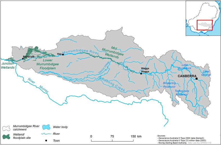
The Murrumbidgee River Valley (Figure 1) covers 84 000 square kilometres of southern New South Wales. It
is bordered by the Great Dividing Range to the east, the Lachlan River Valley to the north and the River
Murray Valley to the south (Green et al. 2011). The river originates in the alpine area of Kosciuszko National
Park and flows through the Monaro High Plains and the low-lying plains of the western Riverina, joining the
River Murray south of Balranald.
Most of the flow in the Murrumbidgee River comes from the upper portion of the catchment (gaining
stream) and is delivered by the main tributary rivers: Cotter, Yass, Molonglo, Queanbeyan, Bredbo,
Numeralla, Goodradigbee and Tumut (Kingsford and Thomas 2001). Several tributaries located immediately
downstream of the dams contribute significant inflows, including Adelong, Adjungbilly, Gilmore, Hillas,
Tarcutta, Kyeamba, Jugiong, Muttama, Billabong and Houlaghans Creeks, and Goobarragandra River (SKM
2011). The middle and lower portions of the catchment do not contribute significant inflows (losing stream).
Regulated water is provided by two major headwater storages, Burrinjuck Dam on the Murrumbidgee River
and Blowering Dam on the Tumut River. Collectively these storages have a capacity of 2 654 gigalitres.
Blowering Dam and Tantangara Reservoir catchments are also affected by the operation of the Snowy
Mountains Hydro Electricity scheme.
(b) Traditional Owners
The rivers and wetlands of the Murrumbidgee River Valley hold significant spiritual and cultural importance
for Aboriginal people. The Wiradjuri are the largest Aboriginal nation in the Murrumbidgee River valley, with
their nation extending from the River Murray in the south to beyond Dubbo in the north, and west to
Balranald. At the western end of the catchment are the traditional land of the Barapa Barapa, Muthi Muthi,
Nari Nari, Nyeri Nyeri, Wadi Wadi, Wamba Wamba, Weki Weki, and Wolgalu nations. The mountains at the
eastern end of the Murrumbidgee River Valley are the country of the Ngunawal and Ngarigo nations. (MDBA
2019).
(c) Important sites and values
Supporting a complex range of natural ecosystems, the Murrumbidgee River Valley contains many significant
in-channel and wetland habitats which provide important habitat for a range of aquatic and terrestrial
species including frogs, fish and waterbirds.
Commonwealth water for the environment is delivered to a number of important regions in the
Murrumbidgee River Valley, including but not limited to the mid-Murrumbidgee wetlands, Yanco Creek
system, Lowbidgee floodplain and Murrumbidgee River. These regions provide critical habitat for a range of
water dependent animals, including internationally listed migratory waterbirds and a range of threatened
species including the southern bell frog, Australasian bittern, trout cod, Murray cod, silver perch, native
catfish, fishing bat; and freckled and blue-billed ducks.
Murrumbidgee River
The Murrumbidgee River spans approximately 1 600 km (Frazier et al. 2005) and is heavily regulated with
26 dams, weirs and irrigation channels (SKM 2011). The lowland section of River between Gandagai and
Balranald consists of meandering channels and wide floodplains, providing a range of aquatic habitats
(Green et al. 2011) which play a critical role in the life cycles of a variety of species (MDBA 2012).
144Water Management Plan 2020-21
River regulation has affected the frequency and duration of floodplain inundation, with the magnitude of
small to medium floods on the Murrumbidgee River having significantly reduced (Frazier et al. 1995). This has
had a significant impact on the river system and the plants and animals that depend on it. It has also altered
the natural seasonal flow patterns, with higher flows now occurring in summer and early autumn to meet
irrigation demand and lower flows occurring during winter and spring when inflows are captured in the dam
(CSIRO 2008, Frazier et al. 2005). River regulation has significantly contributed to native fish declines in the
Murrumbidgee, with the native riverine fish communities remaining in poor condition (Wassens et al. 2020a,
Davies et al. 2008), as part of the Sustainable Rivers Audit, found the overall condition and ecosystem health
of the Murrumbidgee Valley to be very poor.
Mid-Murrumbidgee Wetlands
The mid-Murrumbidgee wetlands are located on the Murrumbidgee River floodplain between Wagga Wagga
and Carrathool and consist of hundreds of lagoons and billabongs (MDBA 2012a), with several listed as
nationally significant in the Directory of Important Wetlands of Australia (EA 2001). The mid-Murrumbidgee
wetlands are also part of the Natural Drainage System of the Lower Murray River Management Catchment
aquatic endangered ecological community listed under the NSW Fisheries Management Act 1994.
The mid-Murrumbidgee wetlands system is characterised by river red gum forests with marginal black box
woodlands, and open water habitat of permanent to semi-permanent wetlands with aquatic plants such as
spike rush, garland lily and spike rush (NSW OEH 2019a, MDBA 2012a, CSIRO 2008). Many of these wetlands
rely on higher flows in the Murrumbidgee River to fill (Murray 2008). However, due to river regulation,
inundation frequency and duration has significantly reduced, resulting in the overall poor condition of the
mid-Murrumbidgee wetlands. Whilst the use of pumping infrastructure to deliver water for the environment
has helped to improve or maintain the condition of a small number of wetlands in the mid-Murrumbidgee, it
is not as ecologically effective as filling wetlands with a reconnecting river flow. As such, a high priority for
environmental watering is reconnecting these wetlands to help the recovery of aquatic vegetation and
improve the health of the river by enabling nutrients and animals to flow back to the river.
Murrumbidgee Irrigation Area wetlands
A number of significant wetlands occur in the Murrumbidgee Irrigation Area and require the use of irrigation
infrastructure to receive environmental water. This includes Fivebough and Tuckerbil Swamps which are
listed as wetlands of international importance under the Ramsar Convention. Both of these wetlands support
a high abundance and diversity of waterbirds, including migratory waterbirds listed under international
agreements (JAMBA, ROKAMBA, CAMBA, Bonn Convention) and threatened species, including the
endangered Australasian bittern and Australian painted snipe (EPBC Act). They also provide significant
breeding habitat for waterbirds including egrets and brolgas (White 2011).
Yanco Creek System
The Yanco Creek system consists of four major creeks, the Yanco, Billabong, Colombo and Forest creeks, and
receives a majority of infows from the Murrumbidgee River but also catchment inflows from the unregulated
Billabong Creek. The system discharges into the Edward River which is an effluent of the River Murray
(Alluvium 2013). This system is known to provide important native fish habitat, including for the threatened
trout cod and freshwater (eel-tailed) catfish (Alluvium 2013). Floodplain wetlands occur throughout the
Yanco Creek system providing important habitat for a range of species, this includes Wanganella Swamp
which is a significant waterbird breeding site located in the Forest Creek system.
145Water Management Plan 2020-21
Lower Murrumbidgee (Lowbidgee) Floodplain
The Lowbidgee floodplain is located between upstream of Maude and Balranald and is listed on the Directory
of Important Wetlands in Australia (EA 2001) and forms part of the Natural Drainage System of the Lower
Murray River Catchment aquatic endangered ecological community listed under the NSW Fisheries
Management Act 1994. The Lowbidgee floodplain contains the third largest river red gum forest in Australia
(Murrumbidgee CMA 2009), some of the largest lignum wetlands in New South Wales (CSIRO 2008) and also
has significant black box and reed bed communities (Murrumbidgee CMA 2009). Some of the Murray-Darling
Basin’s largest breeding sites for colonial nesting waterbirds and migratory waterbird species listed under
bilateral agreements occur on the Lowbidgee floodplain (Wassens et al. 2019a).
The Lowbidgee floodplain can be inundated through controlled diversions from Maude and Redbank weirs or
via overbank flooding from the river. The Lowbidgee floodplain can be divided into three wetland systems
based on distinctive hydrological and ecological characteristics and are Gayini Nimmie-Caira, Fiddlers-Uara
and Redbank systems. Gayini Nimmie-Caira supports extensive areas of lignum shrubland that provides
important waterbird breeding habitat and important habitat for the threatened southern bell frog. Fiddlers-
Uara creeks are the most upstream major distributaries on the Lowbidgee and support black box woodlands
with lignum, nitre goosefoot and river cooba understory (MDBA 2012b, SKM 2011, NSW OEH 2019a). The
Redbank system consists of North and South (Yanga National Park) Redbank and is dominated by river red
gum forests and woodlands with marginal black box woodlands (CSIRO 2008), and a high proportion of open
water and semi-permanent wetland communities, including aquatic herbs and spike rush sedgelands (MDBA
2012b, NSW OEH 2019a). This area also provides important waterbird breeding habitat.
At the western edge of the Lowbidgee is the Western Lakes, which is a complex of ephemeral lakes, wetlands
and connecting waterways. The Western Lakes were disconnected from the Murrumbidgee River in the early
1900’s due to the construction diversion structures on the floodplain (Kingsford and Thomas 2001, NSW
OEH 2012) and remained isolated until flow diversion works enabled the delivery of water for the
environment in 2011 (NSW OEH 2012). This area provides habitat for a diverse range of waterbirds.
Junction Wetlands
The Junction Wetlands lie between Balranald and the confluence of the Murrumbidgee and Murray rivers.
This area consists of a number of creeks, lagoons and areas of river red gum forest, black box and mallee
(SKM 2011).
(d) Stakeholder engagement
In the Murrumbidgee River Valley, the planning, management and delivery of Commonwealth water for the
environment is undertaken in conjunction with a range of partners and stakeholder groups. Key stakeholders
include the New South Wales Department of Planning, Industry and Environment (DPIE) – Biodiversity and
Conservation, NSW Department of Primary Industries (DPI) - Fisheries, WaterNSW, Nari Nari Tribal Council,
scientists from Charles Sturt University engaged in monitoring the outcomes of Commonwealth
environmental water use, Murray-Darling Wetlands Working Group, The Nature Conservancy and the
Murrumbidgee Environmental Water Advisory Group (EWAG).
146Water Management Plan 2020-21
Figure 1: Map of the Murrumbidgee catchment including major towns and headwater storage (courtesy of the Murray-Darling Basin Authority).
147Water Management Plan 2020-21
3.10.2 Environmental objectives
Objectives for environmental water delivery in the Murrumbidgee River Valley are based on long-term
environmental objectives in the Basin Plan, draft state long-term watering plans, the Ramsar site ecological
character description for Fivebough and Tuckerbil swamps and best available ecological knowledge.
The objectives that are targeted in a particular year may vary, depending on available water, catchment
conditions, operational feasibility, and demand for environmental water. These objectives will continue to be
revised as part of the Commonwealth Environmental Water Office’s (CEWO) commitment to adaptive
management.
Vegetation: Maintain or improve the condition, and maintain or increase the extent, of native riparian, in-
channel, floodplain and wetland vegetation.
Waterbirds: Increase waterbird abundance and maintain species diversity by supporting naturally triggered
breeding events, and maintaining suitable refuge, feeding and breeding habitat.
Native fish: Prevent loss of native fish species and improve population structure, distribution, and species
abundance by supporting opportunities for movement, dispersal, reproduction, and recruitment.
Other vertebrates: Provide habitat to support survival of other native aquatic species, including frogs and
turtles; and support opportunities for reproduction and recruitment.
Invertebrates: Provide habitat to support increased microinvertebrate and invertebrate survival, diversity,
abundance and condition.
Connectivity: Support longitudinal connectivity, including with the Murray River, and lateral connectivity
(within constraints) between the river and floodplain and wetlands.
Processes/water quality/resilience: Support in-stream and floodplain productivity; support nutrient, carbon
and sediment transport; provide movement and dispersal opportunities for biota; create quality instream,
floodplain and wetland habitat (i.e. including supporting water quality); and maintain or provide a diversity
of drought refuge habitat across the landscape.
3.10.3 First Nations Environmental Objectives
Advice on environmental water objectives in the Murrumbidgee catchment has been provided by the Murray
Lower Darling Rivers Indigenous Nations (MLDRIN) through the First Nations Environmental Water Guidance
project. Table 1 includes just some of the common objectives for the Murrumbidgee catchment selected as
they were raised by 2 or more participating Nations for the region. It is important to note these objectives do
not represent the detail, depth and complexity of Nations’ localised water-related objectives.
Some of these objectives sit outside the scope of water for the environment to influence, while for others,
the link between water for the environment and the site or issues is not well understood. Environmental
flows will aim to contribute to identified objectives, where possible. The Commonwealth Environmental
Water Holder is committed to continuing to strengthen engagement with all Southern Basin First Nations to
support those Nations to articulate objectives for water management.
Table 1: First Nations environmental water objectives for the Murrumbidgee system for 2020-21 (MLDRIN
2020).
Waterways and Places in Need of watering
Murrumbidgee, Dry Lake, Yanga Lake, Billabong Creek, Baaka (Darling), Wetlands, Billabongs, Floodplains,
Creeks, Other places – parks, forests, islands, Major rivers, Tributaries, Ramsar-listed wetlands.
River Flows and Connectivity
Improve water quality, Improve timing and seasonality of flows, Restore flows in degraded rivers, Remove
barriers and constraints, Improve flows and quantity (rivers and general), Restore wetland hydrology,
Improve river and or floodplain connectivity, Improve tributary flows
148Water Management Plan 2020-21
Vegetation
Old Man Weed, Cumbungi, Black Box, Lignum, River Red Gum, Grasses
Fish
Murray Cod, Yellowbelly, Catfish, Native fish
Waterbirds
Swan, Pelican, Ducks, Eastern Bittern, Sea eagle i, Black Swan.
Other species
Turtles, Frogs, Murray Cray, Shrimp, Mussels, Platypus, Yabbies, Water Rat (Rakali), Macroinvertebrates,
Emu i, Kangaroo i, Birds.
i
Water for the environment targeting other environmental outcomes may influence this species or objective
3.10.4 Recent conditions and seasonal outlook
(a) Recent conditions and environmental water use
The Murrumbidgee Valley has experienced dry conditions from early 2017 up until early 2020 when wetter
conditions prevailed, contributing to the dry conditions easing (BOM 2020). However, by March 2020 inflows
into catchment dams and the Murrumbidgee River had been limited owing to the severity of the dry
conditions experienced over the previous three years. Further rainfall in late April 2020 did contribute to an
improvement to water resources in Murrumbidgee valley storages, resulting in an increase to general
security allocation (NSW DPIE 2020a).
The NSW Department of Planning, Industry and Environment reported in their mid-May 2020 water
allocation statement that the Murrumbidgee Valley has averaged 95th percentile conditions in 2019-20,
which means only five years out of 100 years of historical record experience drier conditions.
In 2019-20, given the hot, dry conditions and low water resource availability in the Valley, the primary focus
of Commonwealth environmental watering was to deliver flows to maintain critical refuge habitats at sites
throughout the Murrumbidgee catchment, including:
• Gayini Nimmie-Caira
• North Redbank
• Yanga National Park
• Toogimbie Indigenous Protected Area
• Murrumbidgee Irrigation Area, including Ramsar listed Tuckerbil Swamp
• selected mid-Murrumbidgee and Junction wetlands via pumping.
Delivery of Commonwealth and NSW water for the environment successfully maintained refuge habitat
which supported:
• native vegetation communities, including growth of aquatic plant species such as spike rush, spiny mud
grass, cumbungi and nardoo
• a high diversity of native fish, including carp gudgeon, Australian smelt, Murray-Darling rainbow fish,
flathead gudgeon, golden perch, bony bream and Murray cod
• all three Murrumbidgee turtle species (broad shelled, eastern long-necked and Macquarie River turtles)
• six species of frogs (barking and spotted marsh frogs, Peron’s tree frog, plains froglet, inland banjo frog
and the threatened southern bell frog)
149Water Management Plan 2020-21
• a diverse range of waterbirds including threatened species (such as Australasian bittern, blue-billed and
freckled ducks) and migratory shorebirds (such as wood sandpiper, sharp-tailed sandpipers, mash
sandpiper, curlew sandpiper and long-toed stint) (CSU 2020; Bourke et al. 2019)
• breeding of frogs, including the threatened southern bell frog; and waterbirds, including royal spoonbills,
darters, cormorants, white ibis, nankeen night heron and potentially Australasian bitterns (which were
heard calling (James Maguire, NSW DPIE, pers. comms 11 March 2020)).
Flows targeting the northern section of Yanga National Park, however, were suspended part way through
delivery due to meter failure at the offtake regulator, resulting in less area inundated than planned. Whilst
not achieving inundation of all targeted areas in the northern section of the Yanga National Park, inundated
areas supported growth of wetland vegetation and provided habitat for native fish, frogs (including
tadpoles), turtles and waterbirds (CSU 2020). The meter at the offtake regulator was repaired in early 2020
and therefore is not anticipated to affect planned delivery of water for the environment into Yanga National
Park in 2020-21.
A key environmental water objective of the refuge habitat maintenance flow in Gayini Nimmie-Caira through
to Tala Lake and associated creek systems in Yanga National Park was to top up Tala Lake and Tala and
Talpee creeks, to support golden perch following the successful spawning and recruitment of this species in
2017-18 and 2018-19. These flows provided refuge habitat throughout Gayini-Nimmie Caira, however, due to
flow rates through new Gayini-Nimmie-Caira infrastructure works being lower than expected, flows topped
up Talpee Creek but did not reach Tala Lake and Creek in Yanga National Park as planned. Top-up flows of
Tala Lake and associated deep creek systems will remain a priority for Commonwealth water for the
environment in 2020-21. The identification of this restricted flow rate has been taken into consideration
during the planning process to mitigate the risk of flows not reaching these sites.
Commonwealth water for the environment was also delivered to specifically target breeding of southern bell
frogs at key sites in Gayini-Nimmie Caira, such as Eulimbah Swamp, where populations had declined and
were at risk of local extinction. Commonwealth, in conjunction with NSW water for the environment,
successfully supported southern bell frog breeding, with tadpoles followed by metamoprhs and juveniles
having been observed (CSU 2020). The 2019-20 watering, coupled with future watering, will contribute to
maintaining these populations in Gayini-Nimmie Caira.
Commonwealth water for the environment was delivered for the first time using pumping infrastructure to
Wanganella Swamp in the Yanco Creek System and to Sunshower Lagoon in the mid-Murrumbidgee to
prevent loss of aquatic vegetation from the lack of higher natural flows and to provide habitat for water
dependent animals. Monitoring at Sunshower Lagoon provided evidence of a significant increase in aquatic
vegetation species diversity compared to previous years (CSU 2020; Bruni, J. et al. 2020) and recorded five
species of frogs, including the threatened southern bell frog, tadpoles, eastern long-necked turtles and
waterbirds (CSU 2020, Bourke et al. 2020). In response to environmental watering at Wanganella Swamp,
NSW DPIE staff, Yanco Creek and Tributaries Advisory Council Environmental Manager and local field
naturalists reported sighting the re-establishment of aquatic vegetation, including with significant cumbungi
and culturally significant nardoo, turtles, frogs and over 25 species of waterbirds including brolga, red-necked
avocet (the first observed in the district since 2010), red-kneed dotterel, white-necked heron, freckled duck,
sharp-tailed sandpiper and Latham’s snipe.
Details of previous Commonwealth environmental use in the Murrumbidgee River Valley are available at:
https://www.environment.gov.au/water/cewo/catchment/murrumbidgee/history.
150Water Management Plan 2020-21
(b) Seasonal outlook
According to the Bureau of Meteorology outlook, across the Murrumbidgee River Valley there is a greater
than 80 per cent chance of above median rainfall for the periods of June to August and July to September
2020 (BOM 2020). Additionally, the chance of exceeding maximum temperatures over the coming months is
variable across the Murrumbidgee River Valley, ranging from high in the eastern end of the valley reducing to
low at the western end of the valley (BOM 2020).
While this forecast indicates that the dry conditions are likely to ease, several months of above average
rainfall are needed to see a recovery from the current long-term drought.
(c) Water availability
The volume of Commonwealth environmental water carried over in Murrumbidgee River Valley for use in
2020-21 is 62 gigalitres.
Allocations against Commonwealth water entitlements in the Murrumbidgee River Valley are determined by
state governments and will vary depending on inflows. On 1 July 2020, the NSW Department of Planning,
Industry and Environment (2020b) announced full opening allocations to high security (i.e. 95 per cent
allocation) and conveyance entitlements as per the valley’s water sharing plan, and 10 per cent allocation to
general security entitlements. Based on this, approximately 137 GL of Commonwealth environmental water
is available for use in the Murrumbidgee River Valley as at 1 July 2020.
Based on the expected available volume of water held by the Commonwealth and other water holders
(including carryover and forecast allocations), as well as recent and forecast catchment conditions, it is
expected that the overall resource availability will be low to moderate in 2020–21. High to very high resource
scenarios are only possible if conditions become substantially wetter.
(d) Environmental demands
The environmental water demands for assets in the Murrumbidgee River Valley in 2020–21 are represented
in Table 2. The capacity to contribute to some of these environmental demands are contingent on a
substantial improvement in water availability in the catchment. For example, a low-level mid-Murrumbidgee
reconnection is a high priority under all water resource scenarios, however, under a low water resource
availability, there would be insufficient environmental water for this action to proceed.
151Water Management Plan 2020-21
Table 2: Environmental demands, priority for watering in 2020-21 and outlook for coming year in the Murrumbidgee River Valley.
Implications for future
Indicative demand (for all sources of water in the system)* Watering history 2020-21
Environmental assets and demands
Long Term Water Plan Likely urgency of demand
planning units (PU) (see Environmental
Required frequency Potential Commonwealth environmental water in 2021–22 if watering
description at bottom of table) Flow/Volume (from all sources of water) demands for water
(maximum dry interval) contribution? occurred as planned in
(all sources)
2020-2021
Mid-Murrumbidgee Wetlands† HIGH to CRITICAL
(includes pumping to Infrastructure assisted delivery to individual high High Potential for water use under Very Low to
To provide refuge
Toogimbie Indigenous priority wetland assets targeting provision of Moderate inflow scenarios
8 in every 10 years – habitat for aquatic
Protected Area) (PU 4, 5, 6, 9 refuge habitat and maintenance of wetland Up to 16 GL (volume contributed will be dependent on
annual Demand met or partially met over the last 5 years animals and maintain HIGH TO CRITICAL
and may also contribute flows vegetation (minimum of 4 GL required under a very resource availability/antecedent conditions, with a
established aquatic
in PU 7, 8, 10, 11, 12, 13) low inflow scenario to support critical refuge (2 years) minimum of 4.5 GL required under a Very Low inflow
habitat.
requirements) (PU 6) However overbank scenario)
connection is preferred
HIGH
The condition of the High Potential for water use under Moderate to High
Tombullen storage releases to augment flows over 7–8 in every 10 years (2 mid-Murrumbidgee
Demand partially met over the last 3 years inflow scenarios subject to natural flow event triggers HIGH
13 GL/day at Darlington Point (PU 6, 7, 8) years) wetlands is generally Up to 10 GL per event
poor due to a lack of
inundation.
HIGH
Minimum of 15.5 GL/day @ Darlington Point for up The condition of the Up to 150 GL under Moderate to High inflow scenarios
to 6 days plus a gradual recession targeting low-lying 7–8 in every 10 years (2 mid-Murrumbidgee
Demand met 2 out of the last 5 years, last met 2017-18. planned for autumn/winter 2021 subject to available HIGH
wetland vegetation and aquatic habitat up to 180 GL years) wetlands is generally allocations
(multiple PU’s) poor due to a lack of
inundation.
Fivebough: Shallow High Potential for water use
Murrumbidgee Irrigation (MI) water 9 in every 10 HIGH
Fivebough 500 ML to inundate 60% of wetland. Fivebough: Required frequency met over the last 6 years minimum of 2 GL under a Very Low inflow scenario
Area Ramsar sites (Fivebough years.
and Tuckerbil wetlands) and Required to maintain HIGH
includes other important ecological character Moderate to High Potential for water use.
Tuckerbil 500 ML to fill Tuckerbil: Required frequency met over last 5 years. under Ramsar
wetlands in MI Area (PU 14) Fill Tuckerbil 4 of every
Up to 4 GL under Low inflow scenario
10 years
MODERATE
Up to 20 GL, targeting up to 1 400 ML/day @ Yanco Demand met or partially met in 2 of the last 5 years, however Low to Moderate Potential for water use
3 in every 10 years (3 Watering, required to MODERATE, subject to
Yanco Creek System (PU 12) Creek off-take targeting low-lying wetland watering required to maintain condition of wetland- maintain the good Up to 10 GL under Moderate to High inflow scenarios.
years) natural cues
vegetation and aquatic habitat and native fish floodplain vegetation condition of wetland- Supplementary use prioritised if available.
floodplain vegetation
CRITICAL to prevent High Potential for water use
Yanco Creek System – Pumping of 1.5 GL to prevent loss of aquatic 7–8 in every 10 years (2 loss of aquatic
Demand met 2 out of the last 5 years Up to 1.5 GL under Very Low to Moderate inflow HIGH
Wanganella Swamp (PU13) vegetation species years) vegetation species
(cumbungi rhizomes) scenarios
MODERATE
Watering following Moderate Potential for water use up to 3 GL if natural
Yanco Creek System –
Up to 6 GL targeting wetland and black box 3 in every 10 years (3 natural cues to flow event triggers an opportunity under Moderate to LOW, subject to natural
Wanganella Swamp and Forest Demand met or partially met in 2 of the last 5 years
vegetation communities years) maintain condition of High inflow scenario. Supplementary use prioritised if cues
Creek (PU13)
wetland-floodplain available.
vegetation
* Volumes may be limited by current channel constraints. Roberts and Marston (2011), Hardwick and Maguire (2012), Alluvium (2013)
† Note: Difference in filling height (i.e. flows required to fill a wetland) vary among the lagoons that make up the mid-Murrumbidgee wetlands, and so their condition and watering requirements vary accordingly
152Water Management Plan 2020-21
Implications for future
Indicative demand (for all sources of water in the system)* Watering history 2020-21
Environmental assets and demands
Long Term Water Plan Likely urgency of demand
planning units (PU) (see Environmental
Required frequency Potential Commonwealth environmental water in 2021–22 if watering
description at bottom of table) Flow/Volume (from all sources of water) demands for water
(maximum dry interval) contribution? occurred as planned in
(all sources)
2020-2021
High Potential for critical/permanent habitats.
HIGH to CRITICAL
Lowbidgee - Core refuge and Up to 74 GL targeting critical refuge habitat Volume contributed will be dependent on resource
Annual watering
permanent aquatic habitat requirements (minimum of 8.5 GL is required under Annual Demand met over the last 5 years availability/antecedent conditions, with a minimum of HIGH to CRITICAL
required for critical
sites (PU7) a Very Low inflow scenario to meet these needs) 4.5 GL required under a Very Low inflow scenario
habitat requirements
increasing to 41 GL under Moderate inflow scenarios
HIGH to CRITICAL to
As required in response
support successful Low Potential, unless colonial waterbird breeding is
Lowbidgee – Rookery sites Up to 30 GL in the event of naturally triggered to naturally triggered
As required completion of naturally triggered under Moderate to Very High HIGH to CRITICAL
(PU7) colonial waterbird breeding colonial bird breeding
waterbird breeding inflow scenario
event
events
MODERATE
River red gum forest and Watering following
Lowbidgee - Up to 40 GL‡ targeting wetland vegetation and Moderate Potential for wetland inundation LOW, subject to natural
spike rush wetlands Met or partially met over the last 5 years natural cues, to
North Redbank (PU7) habitat for native fish, frogs, turtles and waterbirds maintain the good Up to 20 GL under Moderate to High inflow scenarios cues
1-3 years (3 years)
condition of wetland-
floodplain vegetation
HIGH
River red gum forest and Watering required to
Lowbidgee - Yanga National Up to 50 GL‡ targeting wetland vegetation and High Potential for wetland inundation MODERATE, subject to
spike rush wetlands Met or partially met over the last 5 years maintain deep creek
Park (PU7) habitat for native fish, frogs, turtles and waterbirds fish refuges and Up to 25 GL under Moderate to High inflow scenarios natural cues
1-3 years (3 years)
condition of wetland-
floodplain vegetation
Refuge habitat annual HIGH
Lignum dominated Watering following
Lowbidgee - Gayini Nimmie- Up to 50 GL§ targeting wetland vegetation and wetlands High Potential for wetland inundation MODERATE, subject to
Met or partially met over the last 5 years natural cues to
Caira (PU7) habitat for native fish, frogs, turtles and waterbirds maintain the good Up to 25 GL under Moderate to High inflow scenarios natural cues
1 to 5 years, with
duration of up to 7 condition of wetland-
months floodplain vegetation
LOW
Black box and lignum Watering following
Lowbidgee - Fiddlers-Uara Up to 20 GL targeting wetland vegetation and Low Potential for wetland inundation LOW, subject to natural
wetlands every 3 to 7 Met 2 out of the last 6 years natural cues to
(PU7) habitat for native fish, frogs, turtles and waterbirds maintain the good Up to 10 GL under High inflow scenarios cues
years
condition of wetland-
floodplain vegetation
‡
Cumulative volume - includes volume allocated for this asset under Lowbidgee Core refuge and permanent aquatic habitat
§
Cumulative volume - includes volume allocated for this asset under Lowbidgee Core refuge and permanent aquatic habitat
153Water Management Plan 2020-21
Implications for future
Indicative demand (for all sources of water in the system)* Watering history 2020-21
Environmental assets and demands
Long Term Water Plan Likely urgency of demand
planning units (PU) (see Environmental
Required frequency Potential Commonwealth environmental water in 2021–22 if watering
description at bottom of table) Flow/Volume (from all sources of water) demands for water
(maximum dry interval) contribution? occurred as planned in
(all sources)
2020-2021
MODERATE
Wetland habitats and Watering following
Lowbidgee - Western Lakes Up to 30 GL to maintain open water habitats and open water, black box natural cues, to Moderate Potential
Met or partially met over the last 5 years maintain open water LOW
(PU7) floodplain vegetation and lignum wetlands Up to 15 GL under Moderate to High inflow scenario
every 3 to 7 years bodies and good
condition of wetland-
floodplain vegetation
HIGH
Up to 180 GL** for Basin-wide waterbird habitat and Low Potential
Improve the complexity
future population recovery. Improve overall Opportunistic based on and health of priority Up to 90 GL under High inflow scenario. Up to 393 GL
Lowbidgee full system watering
condition of the floodplain. Prioritise use of up to natural occurring rain Met or partially met over the last 5 year waterbird habitat to of Lowbidgee supplementary allocations will be HIGH
(PU7)
393 GL of Lowbidgee supplementary allocations if and flow events maintain species prioritised if made available under High to Very High
made available. richness and aid future inflow scenarios.
population recovery
MODERATE
Contribute up to 10 GL from Tombullen storage to Moderate Potential
higher river flows (freshes) in spring-summer to Watering following
7 in every 10 years Met 2 out of the last 6 years natural cues, required Up to 5 GL if natural flow event triggers an opportunity LOW
support native fish spawning, recruitment,
movement and dispersal. to continue recovery of under Moderate to High inflow scenario.
native fish populations.
MODERATE
Native fish populations
in the lower
Moderate in-channel pulse targeting native fish Murrumbidgee River
movement and recruitment, productivity and in- Moderate Potential
7 in every 10 years Met 2 out of the last 5 years are in poor condition. MODERATE
stream vegetation (flows >3 500 ML/day at Water required for Up to 25 GL under Moderate to High inflow scenarios
Balranald) up to 50 GL improved fish passage
Murrumbidgee River channel, and connectivity,
distributaries and anabranches aquatic habitat and
(PU 6, 7, 8, 9, 10, 11, 12, 13) riverine productivity
MODERATE
Distributary and anabranch freshes to restore flow Watering following
7 in every 10 years to Moderate Potential subject to natural cues MODERATE, subject to
components most impacted by river regulation and Demand met 2 out of the last 5 years natural cues to
annual maintain the good up to 7.5 GL natural cues
support native fish up to 15 GL
condition of wetland-
floodplain vegetation
CRITICAL Contingency in response to poor water quality/aquatic
habitat availability.
Contribute to managing water quality issues within Provide refuge habitat
Contingency in response for aquatic animals due This may include up to 15 GL contingency under very
in-stream and wetland environments across the As required CRITICAL (Contingency)
to poor water quality to poor water quality, low to low inflows, in the absence of IVT (Lower
Murrumbidgee Catchment
including potential Murrumbidgee weir pool stratification, high risk fish
hypoxic conditions. kills).
**
Cumulative volume – includes volumes of all Lowbidgee wetland actions listed above.
154Water Management Plan 2020-21
Implications for future
Indicative demand (for all sources of water in the system)* Watering history 2020-21
Environmental assets and demands
Long Term Water Plan Likely urgency of demand
planning units (PU) (see Environmental
Required frequency Potential Commonwealth environmental water in 2021–22 if watering
description at bottom of table) Flow/Volume (from all sources of water) demands for water
(maximum dry interval) contribution? occurred as planned in
(all sources)
2020-2021
HIGH
Flows greater than 5 GL/day @ d/s Balranald Weir Low Potential under low inflows. Likely to be achieved
and >10 GL/day on the Murray@ Murrumbidgee The condition of the by other environmental watering actions and also
5 in every 10 years Demand met in 2 of the last 5 years Junction Wetland is HIGH
confluence targeting wetland vegetation and habitat through Lowbidgee Supplementary allocations under
for native fish, frogs, turtles and waterbirds generally poor due to a Moderate to High inflow scenarios
lack of inundation
HIGH
Low Potential under low inflows. Likely to be achieved
Junction Wetlands (PU8) Flows greater than 7 GL/day @ d/s Balranald Weir The condition of the by other environmental watering actions and also
targeting wetland vegetation and habitat for native 5 in every 10 years Demand met in 1 of the last 5 years Junction Wetland is HIGH
through Lowbidgee Supplementary allocations under
fish, frogs, turtles and waterbirds generally poor due to a Moderate to High inflow scenarios
lack of inundation
HIGH TO CRITICAL HIGH Potential for water use up to 4 GL under Very
Pumping to individual high priority wetland assets To support continued Low to Moderate inflow scenarios (volume contributed
7–8 in every 10 years (2
targeting wetland vegetation and refuge habitat for Demand met in 4 of the last 5 years recovery of wetland will be dependent on resource availability/antecedent HIGH
years)
native fish, frogs, turtles and waterbirds vegetation and provide conditions, with a minimum of 1.5 GL required under a
refuge habitat Very Low inflow scenario)
Planning Units (PU) 4 – 14. Identified in the Murrumbidgee Long Term Water Plan Part B: Murrumbidgee planning units (draft for exhibition) (NSW OEH 2019b).
PU4: Murrumbidgee River – Tumut River Junction to Berembed Weir PU10: Upper Yanco Creek
PU5: Murrumbidgee River – Berembed Weir to Gogeldrie Weir PU11: Colombo & Billabong Creeks
PU6: Murrumbidgee River – Gogeldrie Weir to Maude Weir PU12: Lower Yanco Creek to Lower Billabong Creek
PU7: Lower Murrumbidgee Floodplain PU13: Lower Billabong and Intersecting Streams
PU8: Murrumbidgee River – Balranald to Murray PU14: Murrumbidgee Infrastructure Dependent Floodplain Wetlands
PU9: Beavers and Old Man’s Creek
155Water Management Plan 2020-21
3.10.5 Water delivery in 2020–21
Based on the demand for water for the environment, water availability (supply), and catchment conditions,
the overall purpose for managing Commonwealth water for the environment in the Murrumbidgee River
Valley in 2020-21 is to maintain, and where possible improve the health and resilience of aquatic ecosystems
including to restore ecologically significant flow components impacted by river regulation under wetter
scenarios. Specifically, for the mid-Murrumbidgee wetlands the purpose is to maintain and ensure their
ecological capacity for recovery and remains a priority under all resource scenarios subject to available
allocations.
Planning for water delivery in the Murrumbidgee River Valley considers all water resource availability
scenarios from extreme dry to wet, thereby enabling water managers to efficiently and effectively respond
to changing conditions. Delivery of water for the environment to many sites and landscapes in the
Murrumbidgee River Valley is scalable (i.e. increase the area, volume delivered, and number sites inundated
on the floodplain), depending on the volume of water available and catchment conditions. For instance,
should climatic conditions and water availability improve there may be opportunities to increase the number
of sites inundated on a floodplain, including sites that require substantial volumes of water to fill.
In the Murrumbidgee Valley, the availability of water for the environment forecast at the beginning of
2020-21 will enable water managers to undertake environmental watering actions planned under all dry
resource scenarios, including very high priority action identified under a moderate resource scenario. Most
of these managed environmental watering actions will initially focus on maintaining key refuge habitats for
waterbirds, native fish, frogs, turtles and other water dependent animals and viability of wetland vegetation
in the mid-Murrumbidgee, Murrumbidgee Irrigation Area, Lowbidgee, Junction wetlands and Yanco Creek
system. This includes delivery of water to Ramsar listed Fivebough and Tuckerbil Wetlands in the
Murrumbidgee Irrigation Area to maintain habitat condition to support threatened waterbird species and
waterbirds listed under international migratory agreements. Maintaining refuge habitat with water for the
environment, particularly in dry conditions, is critical for the survival of waterbirds, native fish, frogs and
turtles (Wassens et al. 2019b). These actions also aim to maintain and prevent loss of threatened southern
bell frog populations by supporting breeding and recruitment of these short-lived species.
Other important wetland habitats on the Lowbidgee floodplain, such as the southern section of North
Redbank, Paika Lake (Western Lakes) and Kia Lake and Swamp (Gayini Nimmie-Caira) which have not
received water for the environment since a managed reconnection in 2017 or large scale natural flooding in
2016, are also targeted to maintain or improve the ecological condition of native vegetation communities,
and provide habitat for water dependent animals.
The volume of environmental water expected to be available for use in early 2020-21 will also enable water
managers to undertake a full system watering of the northern section of South Yanga (moderate resource
scenario action). The primary objective of this action is to top-up Tala Creek and Lake to maintain refuge for
golden perch and other native fish, including those recruited on the floodplain in 2017-18 and 2018-19
(Kopf et al. 2019; Bourke et al. 2019). It will also maintain or improve the condition of native vegetation
communities and provide habitat and recruitment opportunities for water dependent animals.
Under moderate and wet conditions, further larger scale wetland and floodplain inundation including river-
floodplain connection will be targeted to restore components of natural flow regime. These flows aim to
disperse essential nutrients, plants and animals, and support reproduction and improve condition of native
plants, waterbirds, native fish, frogs, turtles and other water dependent animals. These broader scale
watering actions will help to improve the condition and resilience of important sites in the Murrumbidgee
River Valley. Building resilience into the system to help sites to maintain condition and function in dry years,
and to help cope with climate change. The scale of watering will be informed by prevailing climatic
conditions and subject to water availability. River-floodplain connectivity in the lower Murrumbidgee may
also be supported by in-channel flows targeting native fish movement and recruitment and in-channel
productivity.
Note that under wet conditions, unregulated flows are likely to meet many of the Murrumbidgee River
Valley’s environmental demands. However, water for the environment may be used to extend the duration
of unregulated flows or undertake follow-up watering to achieve environmental watering objectives, subject
to constraints and third-party impacts.
156Water Management Plan 2020-21
If a decline in water quality of in-stream or wetland environments across the Murrumbidgee catchment
occurs due to low inflows and dry conditions, or very wet conditions, water for the environment will target
protecting refuge habitat for aquatic animals, including for native fish, subject to available allocations.
A key priority for Commonwealth environmental water remains a managed low-level mid-Murrumbidgee
wetlands reconnection action, which is generally in poor condition due to lack of repeated inundation.
Ideally, a low-level wetlands reconnection with the Murrumbidgee River is required annually to enable the
recovery of wetland vegetation. Low-level wetlands were last inundated by the Murrumbidgee River through
a managed reconnection in winter 2017. Based on the forecast water resource availability for 2020-21 there
is insufficient environmental water holdings for this action to proceed in winter 2020. Should conditions
become wetter and environmental water availability improve throughout 2020-21, a managed low-level
reconnection may be possible in autumn-winter 2021 (if this priority is not met, by natural, unregulated
flows). The aim is to contribute to river flows and inundation of fringing wetlands to continue improvement
and promote recovery of wetland vegetation communities, as well as maintain habitat and provide
movement opportunities for waterbirds and native aquatic species (including fish, turtles, frogs and
invertebrates). The action is subject to water availability, dam release capacities and assessment of potential
third-party impacts. The watering action would also contribute to downstream demands, including Yanco
Creek, the Lowbidgee floodplain including the Junction Wetlands and potentially the lower Murray. The
refinement of arrangements to provide for return flows of environmental water from the Murrumbidgee to
the Murray (a “pre-requisite policy measure” in place from 1 July 2019 under the Basin Plan) will enable
Commonwealth environmental water used in the Murrumbidgee River to be credited for further
environmental use downstream in the River Murray.
Should a managed reconnection not be able to proceed or if mid-Murrumbidgee wetlands are inundated by
unregulated flows during 2020-21, maximising carryover volume into 2021-22 is likely to be targeted for a
potential managed low-level mid-Murrumbidgee reconnection action in 2021-22.
Additional environmental demands may also be identified during the water year as new information
becomes available. Note, under certain levels of water availability, watering actions may not be pursued for a
variety of reasons. For example, this may be due to the environmental demand being met by unregulated
flows or the ability to deliver environmental water may be limited by constraints or infrastructure works
and/or risks.
As in previous years, the use of Commonwealth and NSW water for the environment in the Murrumbidgee
River Valley will be adaptively managed throughout 2020-21 in response to changing water availability, and
environmental conditions and demands.
3.10.6 Monitoring and Lessons learned
(a) Monitoring
Operational monitoring is undertaken for all Commonwealth environmental watering actions and involves
collecting on-ground data with regard to environmental water delivery such as volumes delivered, impact on
the river systems hydrograph, area of inundation and river levels. It can also include observations of
environmental outcomes.
The Monitoring, Evaluation and Research (MER) Program (previously the Long-Term Intervention Monitoring
Project 2014-2019) has sites in the mid-Murrumbidgee Wetlands, Lowbidgee Floodplain and Murrumbidgee
River as focus areas. It aims to understand the environmental response from Commonwealth environmental
watering with respect to the targeted objectives by carrying out monitoring of site condition over many
years.
Details of monitoring activities funded by the CEWO in the Murrumbidgee River Valley can be found at:
https://www.environment.gov.au/water/cewo/catchment/murrumbidgee/monitoring.
Monitoring information is also provided by state governments and The Living Murray program.
157Water Management Plan 2020-21
(b) Lessons learned
Outcomes from monitoring and lessons learned in previous years are a critical component for the effective
and efficient use of Commonwealth water for the environment. These learnings are incorporated into the
way environmental water is managed.
Key findings and recommendations from short term intervention monitoring projects (Baldwin 2019) and the
five year (2014-19) Long-term intervention monitoring (Wassens et al. 2020 a and b, Kopf et al. 2019,
Wassens et al. 2019 b and c) in the Murrumbidgee River Valley is summarised in Table 3.
Table 3: Key lessons learned in the Murrumbidgee River Valley
Theme Lesson learned
Native fish • Spawning and recruitment of native fish species, such as golden perch, can
occur from within the floodplain system. Spawning of golden perch on the
floodplain can be triggered using environmental flows, as demonstrated by
monitoring in 2018.
• Floodplain habitats may be critical for golden perch spawning, growth and
recruitment, and importantly provide rare refuges of high-quality habitat and
productivity during extreme drought conditions. Management decisions to
deliver environmental water to inundate and maintain Lowbidgee floodplain
habitats during spring and summer are important to maintain viable native fish
populations, and to provide food and habitat for resident populations of fish,
frogs and a diverse assemblage of waterbirds.
• Spawning of golden or silver perch in the Murrumbidgee River does not appear
to be translating to recruitment for either of these species. As stocking of silver
perch does not occur in the Murrumbidgee and golden perch stocking is
thought to contribute to ~14 per cent of the golden perch population the
Narrandera zone, it can be assumed that the population is comprised of wild
adults that spawned and recruited locally. Poor young of year recruitment
response has also been exhibited by Murray cod, with abundance of juveniles
being considerably lower in 2018-19 compared with 2014-15 and 2015-16, but
similar to those recorded in 2016-17. The drivers of successful recruitment, the
key locations which support juveniles and the causes for the recent failures in
recruitment remain unknown.
• Since monitoring commenced in 2014, there has been little evidence to
suggest that managing discrete flow peaks within the monitored reaches of
the mid-Murrumbidgee influenced native fish spawning. This might be in part
due to the already higher water flows occurring in the mid-Murrumbidgee
compared to other parts of the river, with irrigation deliveries creating
conditions suitable for spawning throughout the breeding season.
• Wetland native fish species diversity was highest in wetlands that have an area
of permanent water, including Avalon swamp, Telephone Creek and Waugorah
Lagoon.
Frogs • Breeding of many frog species, including the southern bell frog (EPBC Act
vulnerable), is triggered by rising water levels in wetlands during October and
November. Therefore, watering actions in early spring are important to
enhance frog breeding activity and recruitment.
158Water Management Plan 2020-21
Theme Lesson learned
• Southern bell frog numbers, particularly in the Lowbidgee wetlands, have
increased steadily in response to environmental water actions over the
Murrumbidgee Selected Area since monitoring commenced. Nap Nap and
Eulimbah swamps are key refuge habitats for the threatened southern bell
frog and maintaining these sites is important for the long-term recovery of this
species.
Turtles • Maintaining the availability of permanent water holes, particularly at
Telephone Creek and Wagourah Lagoon, is important to support high turtle
numbers.
Waterbirds • Higher waterbird species richness and abundance has been observed at sites
that were inundated by water for the environment in the last five years
compared to wetlands that were dry for extended periods.
• Where possible, Commonwealth environmental water should be prioritised to
provide annual seasonally-inundated habitat (spring-summer) for waterbirds in
the Lowbidgee floodplain and mid-Murrumbidgee wetlands.
• Most waterbirds commence breeding in spring, however, the stimuli for
breeding is usually a combination of season, rainfall and flooding.
• When breeding occurs, water levels in active sites need to be maintained into
summer months to ensure the successful fledging of young birds.
• In the years following large-sale flooding events, provision of environmental
water is likely to be extremely important in creating feeding habitat to support
survival of young birds.
• When there is limited natural overbank flooding, inundating floodplain habitat
to create foraging habitat would benefit waterbird populations in the Murray-
Darling Basin by promoting the survival of juvenile and adult waterbirds.
Vegetation • Despite the wide range of hydrological regimes and geomorphologies of
wetlands in the Murrumbidgee, there is a clear trend that wetlands which
have received environmental water more frequently over the past five years
support higher species richness of water dependent vegetation species and
lower numbers of exotic species.
• River red gum encroachment remains a concern in the mid-Murrumbidgee
wetlands, particularly at McKennas Lagoon. Given the current level of river red
gum at this and other wetlands, mechanical removal coupled with repeat
inundation over several years may be required for restoration.
Microinvertebrates • Higher river levels and cooler temperatures in the Narrandera zone may
impact the development of a productive and diverse microinvertebrate
community. Environmental flows that inundate dried sediments without
creating stable high flows or colder water temperature may be important for
maintaining high levels or riverine microinvertebrate density.
• Watering actions that allow key wetlands to drawn down and temporarily dry
out will contribute to maintaining microinvertebrate densities.
Processes • Rates of metabolism have remained relatively stable over the past five years
Connectivity despite considerable variability in flow volume. There seems to be little
capacity for Commonwealth environmental water to have a significant
influence on the rates of stream metabolism and nutrient availability via
manipulation of water levels in the Murrumbidgee River within existing
capacity constraints under normal flow conditions. However, previous work
has shown that managed return flows do have the capacity to influence
159You can also read