WATERQ2: UNDERSTANDING WATER QUALITY & QUANTITY IN THE LIMPOPO BASIN - USAID
←
→
Page content transcription
If your browser does not render page correctly, please read the page content below
WATERQ2: UNDERSTANDING WATER
QUALITY & QUANTITY IN THE LIMPOPO BASIN
Quarterly Report, 01 January – 31 March 2020
11 May 2020, version 1

Milestone #9

DISCLAIMER: This work was supported by the United States Agency for International Development (USAID), Southern Africa Regional
Mission, Fixed Amount Award 72067419FA00001. This work reflects the work of the authors and does not necessarily reflect the views of
USAID or the United States Government.
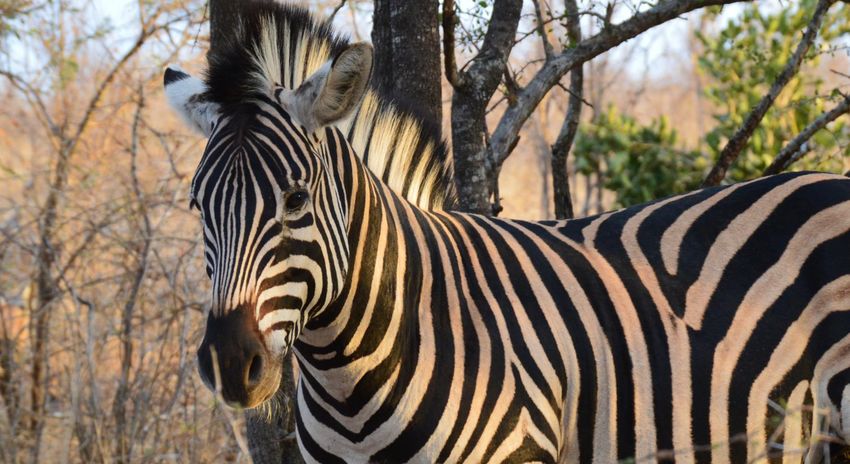
WaterQ2: Understanding Water Quality and Quantity in the Limpopo Basin

Suggested citation:

Kahler, D. M., Edokpayi, J. N., Rose, K. C., (2020). WaterQ2: Understanding Water Quality and
Quantity in the Limpopo Basin, Quarterly Report, 01 January-31 March 2020. Thohoyandou, South
Africa: Limpopo Resilience Lab.

Cover photo: Zebra, Kruger National Park, photo credit: Mackenzie Martin.
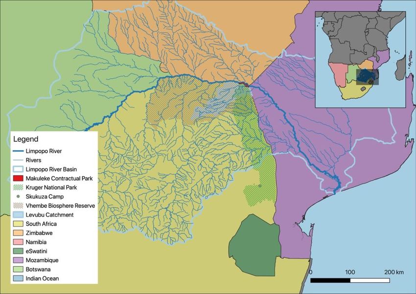
TABLE OF CONTENTS

INTRODUCTION                                                            1

PROJECT ADMINISTRATION                                                  3

PROGRESS TOWARDS MILESTONES                                             3
STAFFING                                                                3
COVID-19 PLANS                                                          3
IMPLICATIONS ON PLANNING                                                4

MODULE 1: WATER MONITORING                                              5

HYDROMETEOROLOGICAL STATION NETWORK                                     5
REMOTE SENSING OF RIVER QUANTITY                                        5
REMOTE SENSING OF WATER QUALITY                                         5
GROUNDWATER-SURFACE WATER INTERACTIONS                                  5
CITIZEN SCIENCE                                                         5
REFERENCES                                                              6

MODULE 2: TRAINING, WORKSHOPS, AND CONFERENCES                          6

INTRODUCTION TO REMOTE SENSING                                           6
INTRODUCTION                                                             6
PARTICIPANTS                                                             6
COURSE DESIGN AND PREPARATION                                            6
SCHEDULE                                                                 7
COURSE DELIVERY AND FACILITATION                                         7
COMPARING PRE AND POST-TRAINING ASSESSMENT OF THE PARTICIPANTS           8
CLOSING OF THE TRAINING                                                 10
CONCLUSION AND RECOMMENDATION                                           10
PROJECT-SPONSORED EVENTS                                                11
WATER INSTITUTE OF SOUTHERN AFRICA (WISA) 2020                          11
ASSOCIATION FOR THE SCIENCES OF LIMNOLOGY AND OCEANOGRAPHY CONFERENCE   11

MODULE 3: BASIN-LEVEL REPORT                                            12

MODULE 4: LIMPOPO RESILIENCE LAB                                        15

MONITORING AND EVALUATION                                               16

MODULES 1 AND 3: WATER MONITORING                                       16
MODULE 2. IWRM TRAINING, WORKSHOPS, AND CONFERENCES                            17

PROJECT PROGRESS                                                               18

WORK PLAN PROGRESS                                                             18

MILESTONE PLAN                                                                 19

FINANCIAL                                                                      21

PRIME RECIPIENT                                                                21
RENSSELAER POLYTECHNIC INSTITUTE (RPI)                                         21

APPROVAL                                                                       22

APPENDIX A: GRADUTE RESEARCH ASSISTANT (GRA)                                   23

APPENDIX B: PROJECT WEBSITE TRAFFIC                                            25

APPENDIX C: KRUGER NATIONAL PARK APPLICATION                                   27

1. TITLE OF THE PROJECT                                                        27
2. CONTACT DETAILS                                                             27
2.1 SENIOR RESEARCHER CONTACT DETAILS                                          27
2.2 CO-WORKERS CONTACT DETAILS                                                 27
3. PARK (S) IN WHICH THE STUDY WILL BE CONDUCTED                               28
4. IN A FEW WORDS, PLEASE EXPLAIN WHY THIS WORK NEEDS TO TAKE PLACE WITHIN A
NATIONAL PARK                                                                  28
5. KEYWORDS                                                                    29
6. EXECUTIVE SUMMARY                                                           29
6.1 RATIONALE                                                                  29
6.2 METHODS                                                                    30
6.3 OBJECTIVES                                                                 32
6.4 OUTCOMES AND MANAGEMENT IMPLICATIONS                                       32
6.5 SIGNIFICANT RISKS                                                          32
6.6 RESOURCES                                                                  33
7. LITERATURE REVIEW                                                           33
8. RATIONALE AND BACKGROUND                                                    33
8.1 WHAT IS THE CONSERVATION, RESEARCH OR MANAGEMENT PROBLEM?                  33
8.2 WHY IS IT IMPORTANT?                                                       34
9. OBJECTIVES & KEY QUESTIONS                                                  34
10. WORK PROCEDURES                                                            34
10.1 STUDY AREA                                                                34
10.2 TYPE OF ACTIVITIES                                                            34
11. BIOLOGICAL SAMPLES REQUESTED (COMPLETE THIS SECTION ONLY IF YOUR RESEARCH
REQUESTS ALREADY SAMPLES)                                                          35
12. ETHICAL CLEARANCE (IF APPLICABLE)                                              35
13. STRATEGIC, SUPPORT AND LOGISTICS                                               35
13.1 FOR WHOM IS THE PROGRAM BEING UNDERTAKEN?                                     35
13.2 DURATION OF THE PROJECT?                                                      35
13.3 WHO WILL BENEFIT FROM THE PROJECT BEING ACHIEVED?                             35
13.4 WHAT QUALIFICATION IF ANY WILL BE OBTAINED FROM THE STUDY?                    35
13.5 WHO IS THE FUNDING PROVIDER AND WHAT IS THE ESTIMATED COST OF THE PROJECT ?   35
13.6 HOW WILL THE STUDY BENEFIT THE NATIONAL PARK’S MANAGEMENT OBJECTIVES?         35
13.7 WHAT ASSISTANCE IS EXPECTED FROM SANPARKS?                                    36
14. MAJOR MILESTONES                                                               36
15. RISKS                                                                          36
REFERENCES                                                                         37

APPENDIX D: PARTICIPANT LIST                                                       39

Project Information
Project Title           Water Q2: Understanding Water Quality and Quantity in the Limpopo Basin
Geographic Locations    Botswana, Mozambique, South Africa, and Zimbabwe
Award Number            72067419FA00001
Implementation Dates    March 2019 to March 2022

Prepared for: Akinwale Aboyade                              Graham Paul
              Agreement Officer’s Technical                 Alternate Agreement Officer’s Technical
              Representative                                Representative
              USAID/Southern Africa                         USAID/Southern Africa

INTRODUCTION
The transboundary Limpopo River Basin crosses Botswana, Mozambique, South Africa, and Zimbabwe.
At over 400,000 km2, the Limpopo River Basin is home to 18 million people living in both rural and
urban areas. Industries in the Basin include businesses in the urban areas and water-intensive uses such
as agriculture and mining; industrial water use is growing rapidly. In addition to the human residents, the
Basin contains some of the most biodiverse natural areas on the planet.

The rainfall in the Basin is heterogeneous with some sub-basins receiving less than 400 mm on average
and other downstream sub-basins in Mozambique receiving over 750 mm annually. Even meteorological
stations located in close proximity demonstrate substantial spatial variation within sub-basins. The Basin
has experienced severe droughts in the last decade. In addition to the variation in the amount of rainfall,
the timing, especially the start of the growing season, has varied significantly. However, there remain
many questions about the reliability of rainfall data and other water measurements due in part to the
infrequent calibration and validation of field site measurements. The limited confidence in these
data, combined with the substantial variation through time and space necessitates an
integrated approach to improve data collection, validation, and overall Basin water
resource management in the Basin.

The goal of this project is to build resilience through the support of Basin stakeholders, including The
Limpopo Watercourse Commission (LIMCOM), to improve governance around water resources
management and water security in the Basin. A systems approach, such as integrated water resources
management (IWRM) is needed to address such complex, large, and interrelated components of water
resources. IRWM is recommended by the United States Agency for International Development (USAID)
Water and Development Strategy Implementation Guide (2014). This context will be combined with
data collection and validation, data sharing, and continuous evaluation of the interrelations that affect
water resources.

This project will support water resources monitoring, and the development of methods for water
quality and quantity measurement based on in situ sensors and satellite measurements. These
measurements will enable characterization of water resource dynamics at the whole Basin scale and
form the foundation for hydrologic modeling that can help estimate hard-to-measure parameters and
also provide holistic assessments of Basin scale stocks and flows. To support data sharing, the project
will use cloud-based, automated data collection and web-based data sharing.

DUQ.EDU/LIMPOPO                                              WATER Q2 QUARTERLY REPORT, JUL-SEP 2019   |   1
The Development of local capacity to maintain water resources and make proactive, scientifically justified management decisions requires a substantial human capital resource that is currently lacking in the Basin. The project will provide training, workshops, and conferences will focus on integrated water resources management (IWRM) and environmental flow analysis. The results of the water resources and biodiversity studies conducted will be compiled into a report for the Basin stakeholders. Continued high-quality data collection, training, and general logistics depends on dependable physical infrastructure. To support data collection efforts as well as training and collaboration the Limpopo Resilience Lab at the University of Venda will be established. The sustainability of lab activity will continue with the implementation of a small user fee beyond the duration of the project. Annual training workshops and conferences will be located at or nearby the Resilience Lab. In this report, the collaborators, Duquesne University (Duquesne), University of Venda (Univen), and Rensselaer Polytechnic Institute (RPI) report their activities and progress in the fourth quarter (Q4) of project year 2019-20 (PY 2019-20). 2 | WATER Q2 QUARTERLY REPORT, JUL-SEP 2019 DUQ.EDU/LIMPOPO
PROJECT ADMINISTRATION

PROGRESS TOWARDS MILESTONES
Student research has continued during this quarter under the supervision of the PIs. The specific
projects will be reported within the module which they support. The quarter began with continued
fieldwork in January. All staff visited field sites in the Soutpansburg mountains and met with other
collaborators. Staff also held meetings with CSIR and the South African Department of Water and
Sanitation to support citizen science in the Limpopo Basin.

STAFFING
As this academic year ends, one of our Graduate Research Assistants (GRA), Mr. Sharp, will graduate
and continue on with his education. Duquesne University has solicited applications for the graduate
program and selected a GRA for the next two academic years, Sophia Bakar, whose resume is included
in Appendix A. Ms. Bakar will commence work on groundwater investigations in the Basin.

COVID-19 PLANS
As the quarter draws to an end, the world continues to confront issues related to Covid-19 (also,
SARS-Cov-2). This pandemic presents unique challenges to this program as many of the researchers are
located in the United States and cannot travel, and South Africa is on lockdown and University of Venda
is closed, under national directive. During this quarter, several research activities continued
uninterrupted; specifically, research staff is able to continue work related to remote sensing and the
measurement of flow in rivers, land classification and land use changes, and hydrologic modeling in key
watersheds.

On 25 March 2020, a letter was sent to the Agreement Officer Representative that outlined out
immediate plans and concerns regarding Covid-19 (Box 1). This letter, in large part, continues to be the
understanding of the PIs at the close of the fourth project-year-quarter with some additional delays as
outlined in this section. During the drafting of this report, the conditions around the world have
continued to evolve and present unique and troubling circumstances for the project team. It is prudent
that these concerns are presented in this report as well. We anxiously await official permission to
extend our remaining milestones by three-months and the performance period of the grant by six-
months. This would give the grant a period that ends 30 September 2022.

Given that South Africa has closed its borders to non-emergency travel, we anticipate that there may be
some additional delays; however, we are unsure of those delays at this time. We also anticipate that
there may be some additional cost due to these delays as the scientists may not be able to complete
their work within the performance period. Specifically, we expect these delays to reduce our ability to
conduct groundwater monitoring, which was scheduled for this summer. Our initial plan was to
conduct groundwater monitoring throughout the project; however, due to delays with shipping
instruments Covid-19, this cannot continue at this time. We will restart monitoring as soon as travel
within South Africa is permitted. We will then start monitoring groundwater in other countries as
travel restrictions are relaxed.

DUQ.EDU/LIMPOPO                                             WATER Q2 QUARTERLY REPORT, JUL-SEP 2019   |   3
University of Venda (Univen) is currently closed and staff in South Africa are working remotely. Outside
of major urban centers, internet connectivity is severely limited. Unfortunately, this has significantly
reduced our communications with staff at Univen.

    25 March 2020

    Akinwale Aboyade
    Agreement Officer’s Representative
    USAID/Southern Africa
    100 Totius Street
    Groenkloof 0027
    Pretoria, South Africa

    Dear Wale and Caroline:

    The situation surrounding COVID-19 has been rapidly developing. In Pennsylvania, on 19 March, the Governor closed all
    non-life-sustaining businesses. In New York, the Governor closed all universities. In South Africa, following President
    Ramaphosa’s emergency declaration on 15 March, all universities were to close last week; students are actively moving out
    of the University of Venda.

    Luckily, with internet connectivity, many of our research functions such as remote sensing analysis and modeling are
    continuing; however, fieldwork has been abruptly halted. This causes a significant disruption to our productivity. Due to our
    inability to travel (even within South Africa), I request that the performance period of this award be extended by six (6)
    months, to 30 September 2022 and all milestones, with the exception of the annual work plan, be extended by three (3)
    months. This would not, at this time, add any additional funds.

    Currently, all research staff are conducting work with remote access. Duquesne University and Rensselaer Polytechnic
    Institute will continue to pay salaries for research staff. University of Venda is subject to South Africa’s shutdown tomorrow
    and they have not announced their plans for salaries. We expect that if these precautions end with the end of this semester,
    around May, the disruption to our ongoing monitoring will be minimal. If, on the other hand, travel restrictions persist, those
    working on fieldwork-intensive projects, including Hilton Shimbabu at University of Venda, and the incoming graduate
    student at Duquesne, may be significantly delayed. If this occurs, we may submit a request for some additional funds; please
    provide guidance on how you would like such a request if possible.

    Sincerely,

    David M. Kahler
Box 1: Copy of letter to AOR

IMPLICATIONS ON PLANNING
Due to Covid-19 restrictions, there have been some necessary changes. Specifically:

      •     Delays on data collection due to travel restrictions (Module 1)
      •     Delays on data collection as Kruger National Park is closed (Module 1)
      •     Conference has been delayed significantly (Module 2, Milestone #11)
      •     Training has been put on temporary hold (Module 2, Milestone #14)
      •     Delay of presentation of the first version of the basin report (Module 3, Milestone #12)

Each of these delays and the proposed response to each is listed within the respective module.

4     |   WATER Q2 QUARTERLY REPORT, JUL-SEP 2019                                                                 DUQ.EDU/LIMPOPO
MODULE 1: WATER MONITORING HYDROMETEOROLOGICAL STATION NETWORK Data from stations established in this project continue to be monitored and uploaded to the Development Data Library, (DDL, data.usaid.gov). Data are available directly from the DDL and linked from the project website. We requested that the data are publicly available in September 2019 and are currently awaiting approval. The project website traffic is summarized in Appendix B. There were plans to continue hydrometeorological station installation in June 2020 in Botswana; however, due to Covid- 19, those plans have been suspended. REMOTE SENSING OF RIVER QUANTITY Research staff has continued to obtain data from Planet Labs satellites for discharge research and water quality, and from Landsat for water quality through Planet Labs’ Education and Research Program. Ms. Martin has made progress on an algorithm to identify the edge of water values in a given Planet Labs image and measure the width of a river along a transect perpendicular to the mean flow. The algorithm is being developed in the open source platform, R, and will be released publicly following testing and peer-review. REMOTE SENSING OF WATER QUALITY Research staff have been working with South African scientists to expand the calibration dataset for this method. Dr. Mlotha met with local scientists in January to identify relevant datasets. Additional data may be taken by staff. The target parameters remain water clarity, chlorophyll, and turbidity. GROUNDWATER-SURFACE WATER INTERACTIONS Ms. Bakar will begin research on groundwater-surface water interactions with hydrologic models based on data collected from surface water observations and groundwater surveys from electrical resistivity tomography (ERT). Tow preliminary fieldwork sites for this work have been identified: the high- elevation watershed of the western Soutpansburg Mountains, just east of Leshiba Mountain that feeds the Sand River and the Makuleke Wetlands in northern Kruger National Park. The research team has proposed the work in Kruger National Park to South African National Parks (Appendix C). This research constitutes the “under research” phase work listed in the module 1 section of the monitoring and evaluation update in this report. CITIZEN SCIENCE The RPI student team has continued to work on the citizen science project for water resources monitoring. This project is inspired by US-based citizen science that uses Google Voice and a server- side python script to collect river height data sent via text message (Fienen and Lowry, 2012). The US project showed that the river level reported by the citizen science program was consistent with traditional data loggers (Lowry and Fienen, 2013). The team is working on enhancing this concept in several ways to make this more applicable to known settings in the Limpopo. Currently, students are working on image processing for a photograph-based system. DUQ.EDU/LIMPOPO WATER Q2 QUARTERLY REPORT, JUL-SEP 2019 | 5
REFERENCES
Fienen, M. N., & Lowry, C. S. (2012). Social.Water—A crowdsourcing tool for environmental data
acquisition. Computers & Geosciences, 49, 164–169. https://doi.org/10.1016/J.CAGEO.2012.06.015
Lowry, C. S., & Fienen, M. N. (2013). CrowdHydrology: Crowdsourcing Hydrologic Data and Engaging
Citizen Scientists. Ground Water, 51(1), 151–156. https://doi.org/10.1111/j.1745-
6584.2012.00956.x
MODULE 2: TRAINING, WORKSHOPS, AND CONFERENCES
INTRODUCTION TO REMOTE SENSING
A course on remote sensing analysis was offered at the University of Venda, 20-24 January 2020, taught
by WaterQ2 scientist, Dr. Joseph Mlotha.
INTRODUCTION
Water resources provide many essential goods and services to biodiversity and support livelihoods for
millions of people. Managing water resources is a critical component for improving food security,
conservation of biodiversity, reducing poverty and building health nations for socio-economic
development. It is in this context that training was organized as part of capacity building to equip
stakeholders and local scientists with some of the needed tools to apply in managing water resources.
Remote sensing and Geographical Information systems (GIS) can improve the routine monitoring of
water resources especially using some of the physical and biological characteristics to assess water
quality and quantity.
PARTICIPANTS
There were 20 participants (Appendix D) drawn from various stakeholders including academia,
government and non-governmental organizations (NGOs) with varying backgrounds and at different
stages in their career. Amongst the 20 participants, 35% were female and 15% had PhDs. We also had
some from Kruger National Park, University of Pretoria and Livhuwani Matsila and Associates.
COURSE DESIGN AND PREPARATION
The course was organized with an aim to empower the participants to apply remote sensing in their
research and management of water and natural resources. Participants were requested to bring their
own personal laptops for the training, and we used QGIS (Quantum Geographic Information System)
open-source software for training. Using an open-source GIS software provides opportunity and
assurance to participants that they can continue working on their projects after the training. With the
development of open source GIS software, there is hope that the number of researchers and scientists
using GIS and remote sensing in water and natural resources management will increase, which can
enhance the efficient monitoring of changes in the environment.
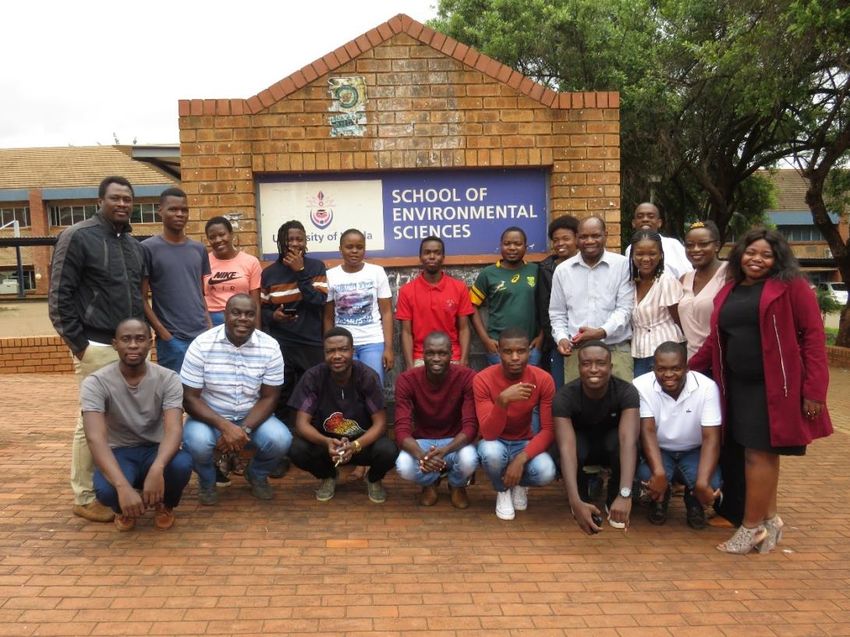
6 | WATER Q2 QUARTERLY REPORT, JUL-SEP 2019 DUQ.EDU/LIMPOPOFigure 1: Course participants at Univen
SCHEDULE
The daily class schedule was from 8 am to 5 pm with two 30 minutes tea/coffee breaks, one in the
morning at 10.30 am and the other in the afternoon at 3.30 pm, and one one-hour lunch break at 12.30
pm. Lunch and tea/coffee breaks were provided by the training sponsors. A class attendance register for
participants was signed every day.
COURSE DELIVERY AND FACILITATION
The training approach combined lectures and practical hands-on exercises. In class, we used PowerPoint
presentations, questions, and answers, discussions, brainstorming ideas and guided lab exercises. We
covered the fundamentals of GIS and remote sensing including the following:
• basics of QGIS -installation, interface, and manipulation,
• sources of data and how to find data,
• image processing and land cover mapping,
• using satellite imagery to estimate water quality,
• applications of remote sensing using QGIS,
• importance and uses of Digital Elevation Model (DEM),
• introduction to Global Position Systems (GPS), and
• project planning and applications using geospatial tools.
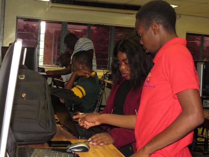
DUQ.EDU/LIMPOPO WATER Q2 QUARTERLY REPORT, JUL-SEP 2019 | 7Participants were encouraged to discuss and help each other during practical sessions (Figure 2). Figure 2. Participants discussing a problem during a class. COMPARING PRE AND POST-TRAINING ASSESSMENT OF THE PARTICIPANTS A pre-training survey was sent out to all participants before the training started. The survey was prepared with four self-assessment questions which had a ranking scale of 1 (Poor) to 5 (Excellent). The pre-training survey aimed to assess what the participant knew about remote sensing and assessing their capabilities in basic satellite data processing before they go through the training. Another evaluation survey was completed by participants at the end of the training. The post-training evaluations included the four questions modified from the pre-training survey plus twelve other questions which were used to assess the whole training from preparation to implementation. The focus was to evaluate if the training increased participants’ understanding and if the knowledge gained could be applied in practice. The results of the pre-training survey indicate that an average of 52% of the participants were able to identify and use different raster data formats before the training while an average of only 34% were able to acquire and process satellite data. When the participants were asked about their ability to conduct analyses on imagery (e.g. assess land-use or land-use change or calculate NDVI), an average of 40% indicated that they were able and an average of 49% indicated that they were able to display the image analysis outputs as a map or figure (e.g., in a report or other presentation). Analyzing the results of the post-training evaluations, we see that there is an increase in all the four questions which were asked in a pre-training survey. The increase in the ranges of an average between 8 | WATER Q2 QUARTERLY REPORT, JUL-SEP 2019 DUQ.EDU/LIMPOPO
26% and 61%. The largest increase is recorded on the ability to process satellite data (data acquisition
and image corrections; e.g., Landsat data) versus the ability to apply in practice the knowledge and
information gained from participating in the training. Table 1 presents a summary of both pre-training
self-assessment surveys and post-training evaluations. The summary results are organized so that we can
compare the results of the two assessment surveys using the mean of each question.

 TABLE 1: SUMMARY RESULTS OF BOTH PRE-TRAINING SELF-ASSESSMENT SURVEY AND POST
 TRAINING EVALUATIONS.

                                          MEAN ON SCALE OF     MEAN ON SCALE OF
 QUESTIONS FOR PRE-TRAINING                                                             QUESTIONS FOR POST
                                          1 (POOR) TO          1 (POOR) TO
 SURVEY                                                                                 TRAINING EVALUATION
                                          5(EXCELLENT), N=20   5(EXCELLENT), N=20

                                                                                        The objectives of this training
                                                               4.58                     were clearly stated and met.

 How would you rate your ability to                                                     Knowledge and information gained
 identify and use different raster data   2.60                 3.90                     from participating: Met my
 formats?                                                                               expectations

 How would you rate your ability to                                                     Knowledge and information gained
 process satellite data (data             1.70                 4.75                     from participating: Could be
 acquisition and image corrections;                                                     applied in practice
 e.g., Landsat data)

 How would you rate your ability to                                                     The training has influenced my
 conduct analyses on imagery (e.g.        2.00                 4.70                     thoughts on the use of GIS and
 assess land-use or land-use change or                                                  Remote sensing.
 calculate NDVI)

 How would you rate your ability to                                                     The training has increased my
 display the image analysis outputs as    2.45                 4.50                     knowledge and skills in GIS and
 a map or figure (e.g., in a report or                                                  Remote sensing.
 other presentation)

                                                               4.58                     The facilitators were well prepared

                                                                                        Physical arrangements: Food
                                                               4.55                     service

                                                                                        Physical arrangements: Location
                                                               4.85
                                                                                        and its environment

                                                                                        What is your overall assessment of
                                                               4.40                     the event?

                                                                                        Communication before and during
                                                               4.35                     the course

                                                               4.35                     Course materials/content covered

                                                                                        Course objectives or expectations
                                                               3.95                     achieved

                                                                                        Course presentation and clarity of
                                                               4.30                     instructor

                                                                                        The software (QGIS) used for the
                                                               3.95                     course

DUQ.EDU/LIMPOPO                                                       WATER Q2 QUARTERLY REPORT, JUL-SEP 2019       |     9
TABLE 1: SUMMARY RESULTS OF BOTH PRE-TRAINING SELF-ASSESSMENT SURVEY AND POST
TRAINING EVALUATIONS.
MEAN ON SCALE OF MEAN ON SCALE OF
QUESTIONS FOR PRE-TRAINING QUESTIONS FOR POST
1 (POOR) TO 1 (POOR) TO
SURVEY TRAINING EVALUATION
5(EXCELLENT), N=20 5(EXCELLENT), N=20
3.85 Length of the course
Overall course organization and
4.45 presentation
Would you be interested in
attending a future follow up course
*100% on more advanced topics? (1 = Y/
0 = N)
*this was a Yes/No question and every participant answered, Yes.
CLOSING OF THE TRAINING
After administering course evaluations to participants, Dr. Joshua Edokpayi a Faculty member at the
University of Venda and the collaborator in the WaterQ2 project spoke on behalf of the University of
Venda. In his closing remarks, Dr. Edokpayi thanked the organizers of the training for choosing the
University of Venda as a venue for the training and reiterated the importance of the training for the
participants who are working on different research projects. Participants were reminded to put in
practice what they learned and continue using the geospatial tools in solving environmental problems
affecting our natural resources. In turn, a representative of the participants spoke expressing gratitude
and appreciation for the opportunity to participate in the course. In her remarks, the representative
thanked the organizers reiterated how important is the training to their research work and studies. The
representative added that the participants are motivated, and they will use the knowledge gained over
the training and also, they are interested to have another training.
At the end, the participants were awarded Certificates of completion and a flash disk each with data and
study materials to enable them to continue using the newly acquired geospatial tools.
CONCLUSION AND RECOMMENDATION
Despite riot police at the university entrance, the training week was not disturbed by demonstrations or
strikes which were being planned by the students in case the negotiations fell apart. Participants were
actively involved and showed interest in another training. The data from pre-training and post-training
indicate that the training was successful to increase knowledge of the participants. The overall (course
organization and presentation) was evaluated at an average of 89%. Despite the success, there are few
suggestions that were presented during course evaluation. I have not ranked the suggestions in order of
importance, however, most participants indicated that the course duration was short, therefore they
suggested to increase the duration to one month.
Other suggestions include the following:
• using ArcGIS instead of QGIS,
• providing water bottles,
10 | WATER Q2 QUARTERLY REPORT, JUL-SEP 2019 DUQ.EDU/LIMPOPO• using high-speed computers instead of personal laptops which many of them were low in hard
disk space of kept freezing when executing an analysis.
• increase the number of participants to make the training available to more people.
• Include exercises for geological analysis using remote sensing
• Include homework during training
• Include group projects
Specifically on the issue of software, the PIs elected to use QGIS as the platform for geographical
information system (GIS) software because (1) it is open source and freely available to all and (2) it is
built on an open source platform and readily modifiable in Python, which allows boundless analysis. The
use of QGIS does not preclude data from being shared across platforms and functions in a similar
fashion to ArcGIS (an ESRI product).
It was unclear to the PIs why some students resisted the use of personal laptops because Univen
computer lab terminals were available for all students. The use of personal laptops was a student
decision.
PROJECT-SPONSORED EVENTS
WATER INSTITUTE OF SOUTHERN AFRICA (WISA) 2020
Unfortunately, due to Covid-19 complications, this conference has been postponed; it is unclear if the
exact schedule at this time.
We planned to publicly announce many of the efforts from this project at this conference, namely, the
basin-level report and the Limpopo Resilience Lab. Due to this scheduling change, the partners are
reviewing alternatives for these activities. At this time, options include the attendance of a different
conference, or the organization or partnership in a virtual event. At this time, another in-person
conference poses the same concerns and has the same vulnerabilities as WISA. While a virtual event
may be advantageous, we are concerned that internet bandwidth limitations would limit participation
from many stakeholders with whom we wish to engage.
ASSOCIATION FOR THE SCIENCES OF LIMNOLOGY AND OCEANOGRAPHY CONFERENCE
This abstract was submitted to the Association for the Sciences of Limnology and Oceanography
(ASLO) conference. Unfortunately, due to Covid-19 restrictions, this conference is on hold.
Assessing Patters of Water Quality in Relation to Surface Water Area Variations within the Limpopo
River Basin, Southern Africa Using Landsat Imagery (1984-2020)
McArd Joseph Mlotha, David M. Kahler, Joshua N. Edokpayi, and Kevin C. Rose
Changes in the water quantity and quality can have major effects on aquatic ecosystems. While manual
sampling can enable characterization through time, it can be cumbersome and time-consuming to
accurately map dynamic changes in inland water bodies, especially in developing countries with limited
resources. In contrast, geospatial technologies like satellite imagery provide useful tools to monitor
water surface area variations together with water quantity and quality over large regions. Here, we
explore variation in surface water extent and estimates of water quality characteristics, including
DUQ.EDU/LIMPOPO WATER Q2 QUARTERLY REPORT, JUL-SEP 2019 | 11chlorophyll-a, turbidity and water clarity. Additionally, we explore how variation in extent corresponds
to variation in water quality seasonally and long-term, 1984-present. We focus on the Limpopo River
Basin in southern Africa. The Basin is transboundary, spanning Botswana, Mozambique, South Africa, and
Zimbabwe. Much of the Basin is arid, characterized by water scarcity and compounded by a changing
climate and increasing drought, as well as increasing withdrawals from agriculture and mining. Our
research indicates that using satellite remote sensing applications is effective to monitor the temporal
and spatial variations of the surface area and quality of inland water bodies, and that water quantity and
quality often co-vary. There is substantial seasonal variation in surface area and water quality,
corresponding to precipitation and land-use patterns. At times of peak water stress, water quality is
frequently impaired.
MODULE 3: BASIN-LEVEL REPORT
The WaterQ2 team has begun to prepare the draft report on water resources management based on
our findings during the first year of the project. Currently, the report is being prepared in parallel with
a draft of a manuscript that will be prepared for publication in a peer-reviewed journal. The outline is
provided here.
Title: Understanding Strengths, Weaknesses, Opportunities, and Threats to Water Resources
Management in the Transboundary Limpopo River Basin
Introduction:
• General overview of the region
o Transboundary
o OECD low- and middle-income countries
o Large basin that has significant correlations to other basins around the world
• Water Resources Law and Policy in Member States
• LIMCOM Treaty and Organization
o How does effective IWRM occur?
o Systems thinking to improve planning and consider externalities
• Basin Stressors
o Population
o Rapid development
o Climate change
• Research questions
o What is the current state of water resources management in the LRB?
o We can define current state of water resources via:
▪ Data: quantity, quality, degree to which data are public, spatial/temporal
coverage
▪ What are current management strategies?
▪ Policies (IWRM)
▪ “Best practices”
o How have management strategies responded to stressors and enhanced resilience?
o What are the bureaucratic and environmental challenges to improved management as
set forth in the IWRM framework, UN transboundary guidance (e.g., 1997 UN
Convention on Non-navigational Uses of International Watercourses)?
12 | WATER Q2 QUARTERLY REPORT, JUL-SEP 2019 DUQ.EDU/LIMPOPOBackground
• Background on IWRM
o Paris Agreement
o Economic Advantages
o UN Definition
o Limpopo Implementation
• LRB Country Profiles
o Country Water Policies
▪ Domestic
▪ Environmental
o Country IWRM initiatives
• Transboundary Guidance
o LIMCOM
o SADC Shared Watercourse
o UN Guidelines
o FAO
Methods
• Stakeholder meeting
o Strengths, weaknesses, opportunities, and threats (SWOT) analysis
• Systematic review of primary and gray (government, NGO, etc) literature
o Scopus search
▪ TITLE-ABS-KEY search
• ( limpopo AND ( basin OR catchment OR watershed
) AND management ) yields 89 articles
• ( limpopo AND ( basin OR catchment OR watershed ) AND (
management OR policy )) yields 95 articles
• ( limpopo AND ( river OR basin OR catchment OR watershed
) AND ( management OR policy )) yields 132
• Possibly restrict years: 2000-present, 1996-present?
▪ Focus Group Surveys- interesting idea to expand on- probably for future papers
▪ Gender? - authorship analysis, heads of organizations,
o Legal case review
▪ Polluter pays, legal precedent
o What data, tools, other resources exist for responding to the needs exposed by the
SWOT analysis?
• Spatial analysis
o Land cover (specific) and NDVI (general) with Landsat
o Surface water cover, water quality
o Analysis: 1990 to 2020 in five- or ten-year increments based on wet and dry seasons
o Land Cover Classes
▪ Water
▪ Wetland
▪ Mining
▪ Forest
▪ Plantation (based on shape of polygons)
DUQ.EDU/LIMPOPO WATER Q2 QUARTERLY REPORT, JUL-SEP 2019 | 13▪ Urban
▪ Small agriculture (subsistence), (small, fragmented)
▪ Commercial agriculture (extensive)
o Analyses and case studies:
▪ Have there been significant changes
▪ What correlations exist with land cover or greenness (NDVI)?
▪ What correlations exist with water quality?
Results and Discussion
• SWOT results
o Data
o Planning for results - long-term planning
o Polluter pays
▪ National Water Act, Part 4, section 19, subsection 5.
▪ 2013 Court case
• Systematic review
o IWRM implementation
o Data
• Land cover changes
o Maps and plots to show trends and correlations in land cover and water quality
o Have there been significant changes in:
▪ evergreen forests?
▪ agriculture?
▪ Have there been trends towards any land cover type?
o Analyses and case studies:
▪ What correlations exist with land cover or greenness (NDVI) and:
• dam construction?
• population?
• types of agriculture?
▪ What correlations exist with water quality and:
• dam construction?
• population?
• types of agriculture?
▪ How does IWRM implementation of certain systems (dams, treatment facilities,
etc) change the local environment in ways that weren’t considered?
Conclusions
▪ Given the state of knowledge, the identified challenges, and the estimated land use, what are the
priorities for water management improvement in the LRB?
▪ Understanding how management of water resources in the Limpopo River Basin adapts to
stressors.
▪ Comparison to transboundary management to nearby basins: Inkomati and Okavango River
Basins.
14 | WATER Q2 QUARTERLY REPORT, JUL-SEP 2019 DUQ.EDU/LIMPOPOMODULE 4: LIMPOPO RESILIENCE LAB University of Venda, under the leadership of Dr. Edokpayi, submitted a concept note (application) for additional funding for instruments to the Resilient Waters program last quarter and is still waiting to hear back. The physical space is still being developed because additional resources may be available for the Lab. DUQ.EDU/LIMPOPO WATER Q2 QUARTERLY REPORT, JUL-SEP 2019 | 15
MONITORING AND EVALUATION

MODULES 1 AND 3: WATER MONITORING
There are two primary research activities that have continued in this quarter that are supported
through this project. They all fall into USAID category, Production Systems Research, as they are a
component of natural resources management: they are both in the field-testing phase of research. The
two areas of research are:

     •   Satellite methods to determine river flow
     •   Satellite methods to determine water quality (e.g., turbidity and chlorophyll)

The investigators have already begun to prepare a manuscript on the river flow method, which will be
submitted to USAID when submitted for publication. For the first quarter, no other activities have
reached monitoring values.

 TABLE 1: MODULES 1&3 INDICATORS

 INDICATOR                                 DISAGGREGATION           CURRENT VALUE     PROJECT TOTAL

 Number of technologies, practices, and    Phase: Under research    1                 3
 approaches under various phases of
 research, development, and uptake as a    Under field testing      2                 2
 result of USG assistance
                                           Made available           0                 0

                                           Demonstrated uptake      0                 0

 Number of peer-reviewed scientific        None                     0                 0
 publications resulting from USG support
 to research and implementation programs

 Number of hectares of land under                                   0                 0
 improved technologies or management
 practices with USG assistance

 Number of datasets shared, which were     Basin country            0                 0
 generated as a result of USG assistance

Data are being uploaded to Development Data Library (DDL). In September 2019, Dr. David Kahler
requested that USAID make the data public. We are still waiting for final approval. No responses have
been received from the DDL. This makes it impossible to make progress on the indicator, “number of
datasets shared.”

16   |   WATER Q2 QUARTERLY REPORT, JUL-SEP 2019                                          DUQ.EDU/LIMPOPO
MODULE 2. IWRM TRAINING, WORKSHOPS, AND CONFERENCES Module 2 contains two primary components: convene stakeholder workshops and trainings; and convene future collaborators at conferences. The first stakeholder workshop has been scheduled for August 2019 at CSIR in Pretoria. The project-level goals for these are to identify environmental champions and cultivate partnerships for future collaborations, especially with the Limpopo Resilience Lab. Project staff has been in close contact with CSIR, Kruger National Park, and Endangered Wildlife Trust. These groups will strengthen the network of water resources and biodiversity professionals in the area. TABLE 2: MODULE 2 INDICATORS INDICATOR DISAGGREGATION CURRENT VALUE PROJECT TOTAL Number of people trained in sustainable Sex Male Female Male Female natural resources management and/or biodiversity conservation as a result of 13 7 18 12 USG assistance Number of water and sanitation sector Institutional scale 0 0 institutions strengthened to manage water resources of improve water supply and sanitation services as a result of USG assistance DUQ.EDU/LIMPOPO WATER Q2 QUARTERLY REPORT, JUL-SEP 2019 | 17
PROJECT PROGRESS

WORK PLAN PROGRESS
Table 3 outlines progress on work plan activities (outlined in the Mobilization Plan) and the ongoing
research activities. As specified in the Project Description, the following activities were planned.

 TABLE 3: PROJECT ACTIVITIES

 #   ACTIVITY                 2019                 2020                   2021                            2021

                              2      3     4       1      2   3    4      1      2       3         4      1

     Startup activities:
     Mobilization Plan,
     Staffing, EMMP

 1   Establish                       *
     meteorological, river,
     and groundwater
     stations, Water
     Monitoring and
     Algorithm Development
     Report

 1   Groundwater
     measurements (ERT),
     to be included in
     Water Monitoring
     Report

 1   Develop satellite
     algorithms

 1   Develop hydrologic
     and water quality
     models

 2   Convene
     stakeholders in
     workshops

 2   Scientific conferences

 2   Training workshops                    *       *

 3   Publish and present
     basin report

 4   Launch Limpopo
     Resilience Lab

                                     Completed                            In-progress/planned

The activities marked with a star (*) have been adjusted for scheduling purposes. Hydrometeorological
data collection was scheduled for July 2019; however, due to scheduling, has been moved to August
2019. This results in a one-month delay of the first report on the locations and data collection outlined
in Milestone 4. Additionally, the staff has decided to add training opportunities in January 2020 following

18   |   WATER Q2 QUARTERLY REPORT, JUL-SEP 2019                                                DUQ.EDU/LIMPOPO
recruitment in the first stakeholder meeting. Groundwater investigations have also been delayed due to
an unforeseen shipping delay.
MILESTONE PLAN
TABLE 4: MILESTONE PLAN
# MILESTONE 2019 2020 2021 2021
Quarter: 2 3 4 1 2 3 4 1 2 3 4 1
1 Mobilization Plan Apr
2 Environmental Jun
Mitigation and
Monitoring Plan
3 Quarterly Report Jul
4 Water Monitoring Dec*
and Algorithm
Development Report
5 Stakeholder Nov
Workshop Report
6 Annual Work Plan Aug
7 Quarterly Report Dec*
8 Quarterly Report Apr*
9 Quarterly Report^ Apr
10 LRL Website and Apr
Planning
11 Scientific Conference Jul
12 Basin Report Jul
13 Quarterly Report Jul
14 Stakeholder Sep
Workshop Report
15 Annual Work Plan Aug
16 Quarterly Report Oct
17 Quarterly Report Jan
18 Quarterly Report^ Apr
19 Scientific Conference Jul
20 Quarterly Report Jul
DUQ.EDU/LIMPOPO WATER Q2 QUARTERLY REPORT, JUL-SEP 2019 | 1921 Stakeholder Sep
Workshop Report
22 Water Monitoring: Aug
Two manuscripts
23 Annual Work Plan Aug
24 Quarterly Report Sep
25 Quarterly Report Jan
26 Basin Report Mar
27 LRL Continuity Mar
Report
28 Quarterly Report Apr
Shaded items are completed or pending approval. It is recommended that the Milestone Plan be revised
so that the annual cost share report, which was originally marked to occur for the reporting quarters
#5, 9, and 12, will be included in quarterly reports, marked with a carrot (^), for reporting quarters #4,
8, and 12. The water monitoring report (Milestone #4) is also marked (*).
20 | WATER Q2 QUARTERLY REPORT, JUL-SEP 2019 DUQ.EDU/LIMPOPOFINANCIAL PRIME RECIPIENT Duquesne University has used project funds for the expenditures in Table 5. Duquesne University has used other funds for the expenditures in Table 6; these represent cost share. TABLE 5: PROJECT EXPENDITURES ITEM Q4 EXPENDITURE PROJECT TOTAL Sensitive financial information has been withheld from the published report. Total $22,709.48 $238,023.94 Notes: Student support is billed to accounts at the start of the University’s fiscal year in June for the upcoming academic year. TABLE 6: COST SHARE ITEM Q4 EXPENDITURE PROJECT TOTAL Sensitive financial information has been withheld from the published report. Total $0 $52,049.46 RENSSELAER POLYTECHNIC INSTITUTE (RPI) TABLE 6: COST SHARE ITEM PY 2019-20 PROJECT TOTAL Sensitive financial information has been withheld from the published report. Total $27,121.13 $27,121.13 University of Venda does not have any cost share to report this project year. DUQ.EDU/LIMPOPO WATER Q2 QUARTERLY REPORT, JUL-SEP 2019 | 21
APPROVAL
This Quarterly Report has been received and approved by USAID. This satisfies the requirements set
forth in the Milestone Plan, item #9: Completion of Quarterly Report (Q4).

Signature:       ____________________________________________________________

Name:            ____________________________________________________________
                 Agreement Officer’s Representative

Date:            ____________________________________________________________

22   |   WATER Q2 QUARTERLY REPORT, JUL-SEP 2019                                     DUQ.EDU/LIMPOPO
APPENDIX A: GRADUTE RESEARCH ASSISTANT (GRA) The resume for Sophia Bakar is included here. DUQ.EDU/LIMPOPO WATER Q2 QUARTERLY REPORT, JUL-SEP 2019 | 23
Personal information was withheld from the published version of this report.

24   |   WATER Q2 QUARTERLY REPORT, JUL-SEP 2019                               DUQ.EDU/LIMPOPO
APPENDIX B: PROJECT WEBSITE TRAFFIC
Site visits have come from around the world (Figure B1) with a concentration from the United States of
America and South Africa (Table B1).

Figure B1: Map of audience for 01 January to 31 March 2020. Plotted are unique users for the period according to access of any page within
the Limpopo Resilience Lab website (as indicated in Appendix A, excludes the DSC). Graphic from Google Analytics.

 TABLE B1: GEOGRAPHICAL WEBSITE TRAFFIC REPORT FROM 01 JUNE TO 10 DECEMBER 2019

 COUNTRY                               UNIQUE USERS           SESSIONS         PAGES PER SESSION              AVERAGE SESSION
                                                                                                              DURATION (H:MM:SS)

 United States of America                       99                 120                    1.60                           0:00:28

 South Africa                                    6                  9                     1.67                           0:00:14

 Australia                                       1                  1                       6                            0:00:00

 Canada                                          1                  1                       3                            0:00:00

 China                                           1                  1                      1.5                           0:00:00

 Germany                                         1                  1                       5                            0:00:00

 United Kingdom                                  6                  1                       1                            0:00:00

 Nigeria                                         2                  1                       1                            0:00:00

DUQ.EDU/LIMPOPO                                                                WATER Q2 QUARTERLY REPORT, JUL-SEP 2019               |   25
Russia 1 1 1 0:00:00 Saudi Arabia 1 1 1 0:00:00 Unknown 1 1 1 0:00:00 There has been a decrease in site visits from the previous report. This is expected as we do not have any training offered at this time. 26 | WATER Q2 QUARTERLY REPORT, JUL-SEP 2019 DUQ.EDU/LIMPOPO
APPENDIX C: KRUGER NATIONAL PARK APPLICATION
Some personal information has been removed.

                       RESEARCH PROJECT APPLICATION FORM

1. TITLE OF THE PROJECT
Electrical resistivity tomography (ERT) investigation of water resources in the Luvuvhu/Limpopo
confluence and Makuleke Wetland

2. CONTACT DETAILS

2.1 SENIOR RESEARCHER CONTACT DETAILS
   ▪   S. A. Bakar
       Graduate Research Assistant (thesis research)
       Duquesne University
       Pittsburgh, PA 15282, USA
       bakars@duq.edu

2.2 CO-WORKERS CONTACT DETAILS
   ▪   Dr. D. M. Kahler
       Assistant Professor (thesis committee chair)
       Duquesne University
       600 Forbes Ave.
       Pittsburgh, PA 15282, USA
       +1 (202) 630-8757
       kahlerd@duq.edu, david.m.kahler@gmail.com
   ▪   Dr. J. N. Edokpayi
       Senior Lecturer
       University of Venda
       Private Bag x5050

DUQ.EDU/LIMPOPO                                           WATER Q2 QUARTERLY REPORT, JUL-SEP 2019   |   27
Thohoyandou 0950, South Africa
Joshua.Edokpay@univen.ac.za
School of Environmental Sciences, University of Venda
▪ Dr. K. C. Rose
Assistant Professor
Rensselaer Polytechnic Institute
110 Eight St.
Troy, NY 12180, USA
rosek4@rpi.edu
▪ Dr. E. Riddell
Water Resources Manager, Conservation Services
Kruger National Park
▪ R. Petersen
Freshwater Scientist, Scientific Services
Kruger National Park
▪ M. L. Martin
Graduate Research Assistant
Duquesne University
Pittsburgh, PA 15282, USA
martinm4@duq.edu
▪ Thivhonali Hilton
Graduate Research Assistant
University of Venda
Thohoyandou 0950
Limpopo, South Africa
▪ Ntwanano Mutileni
Graduate Research Assistant
University of Venda
Thohoyandou 0950
Limpopo, South Africa
3. PARK (S) IN WHICH THE STUDY WILL BE CONDUCTED
Kruger National Park, Makuleke Wetland Contractual Park
4. IN A FEW WORDS, PLEASE EXPLAIN WHY THIS WORK NEEDS TO TAKE PLACE WITHIN
A NATIONAL PARK
This proposed research will leverage existing research efforts and funding to understand water
resources and biodiversity in the Limpopo River Basin. Kruger National Park is an important area in this
transboundary watershed. Specifically, several rivers that drain high-elevation catchments come
together in the Makuleke wetlands just before flowing into Mozambique and the Olifants River, which is
affected by mining operations in South Africa flows through Kruger National Park as it passes to
Mozambique. Complementing our existing research in the Limpopo River Basin, our proposed research
in Kruger National Park focuses on water quantity and quality across the Park, including areas that are
not necessarily in the Limpopo River Basin.
28 | WATER Q2 QUARTERLY REPORT, JUL-SEP 2019 DUQ.EDU/LIMPOPOThe proposed work supports our collaborative research program, Understanding Regulators of Kruger Park Water Quantity and Quality to Better Conserve Biodiversity (Kahler, 2020). The primary goal of this project is to determine the overall flow from the Luvuvhu catchment to the total Limpopo water resources. Specifically, we hypothesize that there is a significant contribution of groundwater flow through the Makuleke region. This would further support our hypothesis that the high-elevation catchments play an important role in water resources. This project will, through ERT survey contribute to the baseline conceptual model development of groundwater-surface water process, which to our knowledge, has not yet been undertaken in the Makuleke wetlands. Kruger National Park is an important and unique area as it is home to emblematic and critical species. The groundwater-surface water interactions play a role in the water available to these macrofauna. We expect that our examination of groundwater flow in the Makuleke will elucidate the water availability. 5. KEYWORDS Water Resources Management; Water Quality; Water Quantity; Groundwater; Biodiversity 6. EXECUTIVE SUMMARY 6.1 RATIONALE The transboundary Limpopo River Basin crosses Botswana, Zimbabwe, South Africa, and Mozambique. At over 400,000 km2, the Limpopo Basin is home to 18 million people living in both rural and urban areas. Industries in the Basin include businesses in the urban areas and water-intensive uses such as agriculture and mining; industrial water use is growing rapidly (Petrie et al., 2014). In addition to the human residents, the Basin contains some of the most biodiverse natural areas on the planet (Kahinda et al., 2016). The rainfall in the Basin is heterogeneous with some sub-basins receiving less than 400 mm on average and other downstream sub-basins in Mozambique receiving over 750 mm annually; meteorological stations located in close proximity demonstrate substantial spatial variation within sub-basins (Petrie et al., 2014). The Basin has experienced severe droughts in the last decade. In addition to the variation in the amount of rainfall, the timing, especially the start of the growing season, has varied significantly (Edokpayi et al., 2018). Investigation in Kruger National Park will help us understand the greater water resources in the transboundary Limpopo River Basin and the role of water resources management for ecosystem services including biodiversity conservation, domestic, agricultural, and industrial uses. This research focuses on the use of specialized measurement techniques for groundwater and traditional surface water monitoring; these data will be used in hydrologic models to enhance our overall understanding of the hydrology in the area and improve basin-wide water management. The investigation in the Makuleke wetlands and surrounding areas provide a protected natural setting where groundwater and surface water interact in unique ways (Figure C1). The 22,000 ha Makuleke area (Fabricius & Collins, 2007) is known for the community that inhabits it and the waterbodies that comprise the Makwadzi Pan, which has shown variations in paleoclimate (Ekblom et al., 2012). DUQ.EDU/LIMPOPO WATER Q2 QUARTERLY REPORT, JUL-SEP 2019 | 29
Figure C1: Location of the Makuleke Contractual Park within Kruger National Park in South Africa.

6.2 METHODS
We plan to use electrical resistivity tomography (ERT) to resolve the shape of the water table over time
(Hubbard et al., 1999) and estimate the parameters for groundwater flow (Vanderborght et al., 2005).
We will use induced polarization (IP) to further estimate the aquifer parameters (Slater, 2007),
specifically porosity and permeability. Measurements will be taken along multiple transects throughout
the area both parallel and perpendicular to the land surface gradient as a surrogate for the aquifer
(Figure C2). Measurements will also be made near perennial and annual surface water bodies.

We plan to configure the instrument to sample electrical resistivity based on a Wenner array and a
Schlumberger array; based on our experience, we expect that our linear 48 electrode, 240 m array will
sense approximately 80 m in depth. Water has a significantly higher conductivity than the air-water
mixture present in the vadose (unsaturated) zone; this allows the instrument to sense an abrupt
decrease in resistivity at the piezometric surface (water table). The depth of the water table will
indicate the amount of aquifer water storage and the gradient of the water table, with other parameters,
will indicate the transport of water through the aquifer. These measurements over time will allow us to
monitor the groundwater component of the local water balance.

In the saturated aquifer, solid particles, which have an intrinsic charge, have bound layer (called the Stern
layer) and a diffuse layer of ions in the water that surround the solid particle called an electrical double
layer (EDL). This layer is subject to polarization during the imposed signal from the instrument (Figure
3), which is called induced polarization (IP). When the emitted signal is turned off, the receiver

30    |   WATER Q2 QUARTERLY REPORT, JUL-SEP 2019                                                   DUQ.EDU/LIMPOPO
continues to monitor for changes and detects the relaxation of the EDL. The signal, measured as
resistivity, is related to the permeability of the soil (Dahlin et al., 2002) in that thin EDL due to smaller
individual water channels are more similar to clay (Leroy & Revil, 2009) compared to larger individual
water channels, which are more similar to sandy deposits (Revil, 2012).
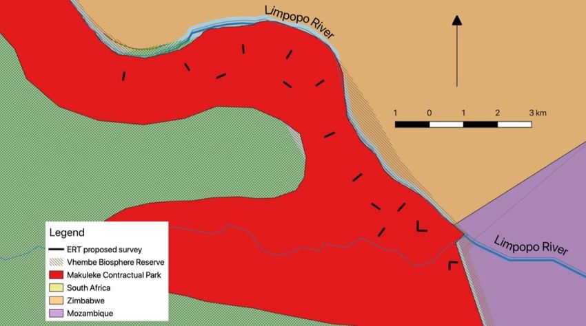
Figure 2: Proposed ERT survey locations surrounding the Luvuvhu-Limpopo confluence. These survey transects were selected by examination
of satellite images and may be adjusted based on the hydraulic measurements and consultation with Park scientific staff and other stakeholders
to minimize disturbances to environmentally or culturally sensitive areas.
Stern layer Diffuse layer
+ +
+ ++ +
+ + + + + +
+
+ + + + +
+ + + +
+ + + + +
+ +
+ +
+ + + + +
+ + + + +
+ + + + +
+ ++ + +
Field off Field on Field off Field on
Figure 3: EDL from charged dielectric material, from (adapted from Pesch, 2019). Both the fixed (a) and diffuse (b) layers are diagramed. IP
measures the response from the polarized (right of each layer) to return to a normal distributed layer.
Darcy’s Law (Freeze & Cherry, 1979) relates the specific discharge of an aquifer to the hydraulic
conductivity and the pressure gradient, typically taken as the slope of the piezometric surface.
We will use ERT data collected from this project to construct hydrologic models of groundwater-
surface water interactions in MODFLOW (U.S. Geological Survey) (Brunner et al., 2010; Guevara
Ochoa et al., 2020). Additionally, for basin-scale monitoring, we will use the U.S. Army Corps of
Engineers, Hydrologic Engineering Center software suite: Hydrologic Modeling System (HEC-HMS) and
River Analysis System (HEC-RAS). Specifically, HEC-HMS will be used to estimate the general baseflow
contributions based on the flow and precipitation data available in the area. These models will be used
to determine the groundwater flow into the Limpopo River. We will also consider observations made
DUQ.EDU/LIMPOPO WATER Q2 QUARTERLY REPORT, JUL-SEP 2019 | 31by satellite gravity anomaly from the Gravity Recovery and Climate Experiment (GRACE) data (Richey et al., 2015). 6.3 OBJECTIVES Our objective in this project is to collect water table height and gradient, and induced polarity data that can be used in hydrologic models. These data and models will be used to measure the groundwater resources, volume and flow, and help elucidate the groundwater-surface water interactions in the Makuleke area. Multiple samples taken across seasons through multiple years will help to determine the role of the groundwater flow in the Levuvhu catchment. This supports the goals of our overall program through the estimation of the groundwater flow into the Limpopo River and elucidate the groundwater-surface water interactions in the Makuleke wetlands and surrounding water bodies. We hope that this will support the conservation work by Kruger with increased groundwater monitoring. Groundwater in southern Africa is an important resource especially in the context of climate change. Groundwater in the Limpopo Basin holds great potential for increased water access; however, groundwater measurement data are currently insufficient to calculate sustainable total withdrawal rates (Petrie et al., 2014). Our objective is that resource managers will have an improved basis for scientifically based decisions and may be able to utilize groundwater resources more effectively to increase (e.g., agricultural) productivity and conserve biodiversity with improved data collection, validation, and sharing of these data. 6.4 OUTCOMES AND MANAGEMENT IMPLICATIONS Our goals are to support Basin stakeholders, including Kruger National Park, to improve governance around water resources management and water security in the Basin. We hope to accomplish this by collecting and sharing hydrologic data, training students, resource managers, and decision-makers, facilitating networking and communication among institutions, and establishing and supporting dedicated technical resources in the Limpopo Resilience Lab housed at the University of Venda. In Kruger, we will expand our data collection on water quality and quantity. Our focus will be in the Makuleke Wetlands, a unique hydrological system. Our current work includes the hydrodynamics and water quality of the Luvuvhu/Mutale system. The Luvuvhu River joins the Limpopo River in Kruger with the Makuleke Wetlands at their confluence. Data collection will greatly assist the modeling of water quality and quantity in these northern watersheds. We also seek collaborations with Kruger staff for other mutually beneficial work throughout the Park. 6.5 SIGNIFICANT RISKS We have examined the potential impact of the use of Electrical Resistivity Tomography (ERT) in our existing Environmental Mitigation and Monitoring Plan (EMMP) (https://pdf.usaid.gov/pdf_docs/PA00TRM9.pdf). The instrument involves hammering 48 metal electrodes (steel, 1 cm diameter, 5 cm into the soil). To mitigate potential impacts, we will not insert electrodes into steep slopes or sensitive soils or delicate vegetation. 32 | WATER Q2 QUARTERLY REPORT, JUL-SEP 2019 DUQ.EDU/LIMPOPO
You can also read