Wekiva Trail Extension-Segment 5 (formerly known as the Tavares-Mount Dora Trail) Corridor Planning Study Technical Memorandum - FM #: 405854-1 ...
←
→
Page content transcription
If your browser does not render page correctly, please read the page content below
Wekiva Trail Extension-Segment 5
 (formerly known as the Tavares-
        Mount Dora Trail)
     Corridor Planning Study
     Technical Memorandum
 Project Limits: from Disston Avenue (Wooton Park) in
       Tavares to Tremain Street in Mount Dora
                     FM #: 405854-1
                  Date: December 2020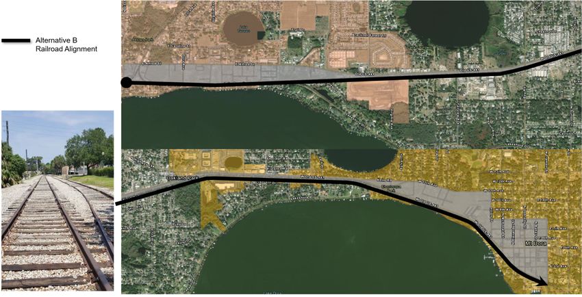
Table of Contents

   1 Report Purpose ............................................................................................................... 1
   2 Introduction ..................................................................................................................... 1
        2.1      Project Description .................................................................................................. 1
        2.2      Study Area Description ........................................................................................... 1
        2.3      Study Approach ...................................................................................................... 3
   3 Purpose and Need ........................................................................................................... 4
        3.1      Purpose................................................................................................................... 4
        3.2      Need for Improvement ............................................................................................ 4
   4 Traffic ............................................................................................................................... 6
        4.1      Existing Year Volumes ............................................................................................ 6
        4.2      Existing Operational Analysis (LOS) ....................................................................... 8
   5 Planning Concept Analysis and Development ........................................................... 10
        5.1      No Build Planning Concept .................................................................................. 10
        5.2      TSM&O and Multi-Modal Planning Concepts ...................................................... 10
        5.3      Design Criteria ...................................................................................................... 11
        5.4      Build Concepts ...................................................................................................... 18
            5.4.1 Build Concepts Alignment and Typical Sections ............................................. 18
        5.5      Initial Concepts Comparison and Matrix ............................................................... 31
            5.5.1 Social & Economic Evaluation ........................................................................ 31
            5.5.2 Cultural Resources Evaluation ........................................................................ 34
            5.5.3 Natural Resources Evaluation ........................................................................ 36
            5.5.4 Physical Characteristics Evaluation ................................................................ 39
            5.5.5 Trail Experience .............................................................................................. 41
            5.5.6 Traffic Operations And Safety ......................................................................... 42
            5.5.7 Cost Estimates ................................................................................................ 43
            5.5.8 Trail Evaluation Matrix .................................................................................... 45
        5.6      Selected Concept Description............................................................................... 46
        5.7      PEL Questionnaire ................................................................................................ 46
   6 Public Involvement ....................................................................................................... 47
        6.1      Project Visioning Team ......................................................................................... 47
            6.1.1 Project Visioning Team Meeting #1 ................................................................ 47
            6.1.2 Project Visioning Team Meeting #2 ................................................................ 48
        6.2      Public Meeting ...................................................................................................... 49
   7 Next Steps and Commitments ..................................................................................... 49

                                                                                                                                             i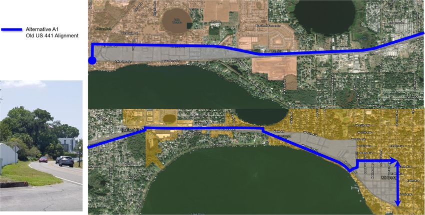
List of Figures

   Figure 1 | Study Area Map ..................................................................................................... 2
   Figure 2 | Study Approach ..................................................................................................... 3
   Figure 3 | Wekiva Trail Segments.......................................................................................... 5
   Figure 4 | Annual Average Daily Traffic (AADT) .................................................................... 7
   Figure 5 | Level of Service Examples .................................................................................... 8
   Figure 6 | Corridor Level of Service (LOS) ............................................................................ 9
   Figure 7 | Planning Concept A-1 Alignment ......................................................................... 19
   Figure 8 | Planning Concept A-1 Typical Section A-A ......................................................... 20
   Figure 9 | Planning Concept A-1 Typical Section B-B ......................................................... 21
   Figure 10 | Planning Concept A-1 Typical Section C-C ....................................................... 22
   Figure 11 | Planning Concept A-1 Connector Alignment Typical Section D-D .................... 23
   Figure 12 | Planning Concept A-2 Alignment....................................................................... 25
   Figure 13 | Planning Concept A-2 Typical Section E-E ....................................................... 26
   Figure 14 | Planning Concept B Alignment .......................................................................... 28
   Figure 15 | Planning Concept B Typical Section A-A – 14-foot Trail ................................... 29
   Figure 16 | Concept B Typical Section B-B ......................................................................... 30

List of Tables

   Table 1 | Mount Dora, Tavares and Lake County Design Criteria ....................................... 11
   Table 2 | Design Criteria ...................................................................................................... 13
   Table 3 | Consistency with Local Plans ............................................................................... 31
   Table 4 | Maintaining Agencies & Community Support ....................................................... 33
   Table 5 | Potential Right of Way Impact(s) .......................................................................... 33
   Table 6 | Summary of Social Resources in the Study Area by Concept .............................. 34
   Table 7 | Cultural Resources Concepts Comparison ........................................................... 35
   Table 8 | Wetland Impacts ................................................................................................... 36
   Table 9 | Floodplain Impacts................................................................................................ 37
   Table 10 | Wildlife in Study Area.......................................................................................... 37
   Table 11 | Plant Species in Study Area ............................................................................... 38
   Table 12 | Utility Impacts ..................................................................................................... 39
   Table 13 | Drainage Impacts................................................................................................ 40
   Table 14 | Intersection and Midblock Crossings .................................................................. 41
   Table 15 | Nearby Households and Businesses .................................................................. 42

                                                                                                                                    ii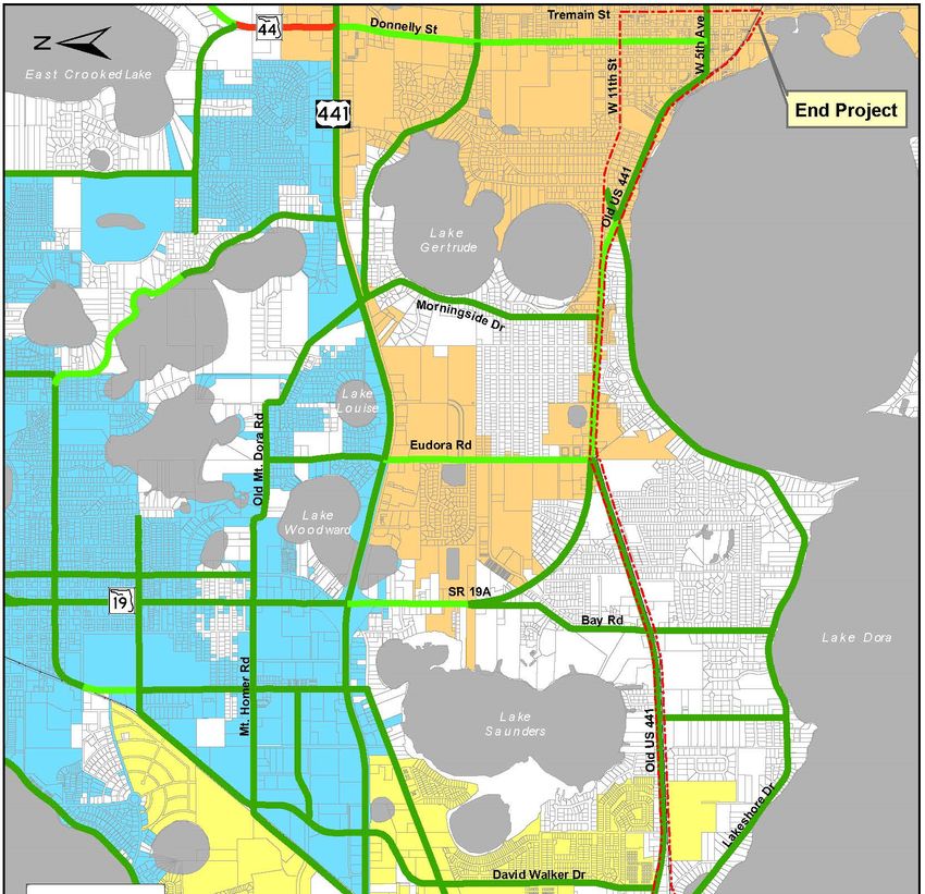
Table 16 | Speed Limit ......................................................................................................... 42
   Table 17 | Trail Offset .......................................................................................................... 43
   Table 18 | Cost Estimates.................................................................................................... 44
   Table 19 | Trail Concepts Evaluation Matrix ........................................................................ 45

Appendices

   Appendix A: Concept Plans
   Appendix B: Public Involvement Plan

                                                                                                                                     iii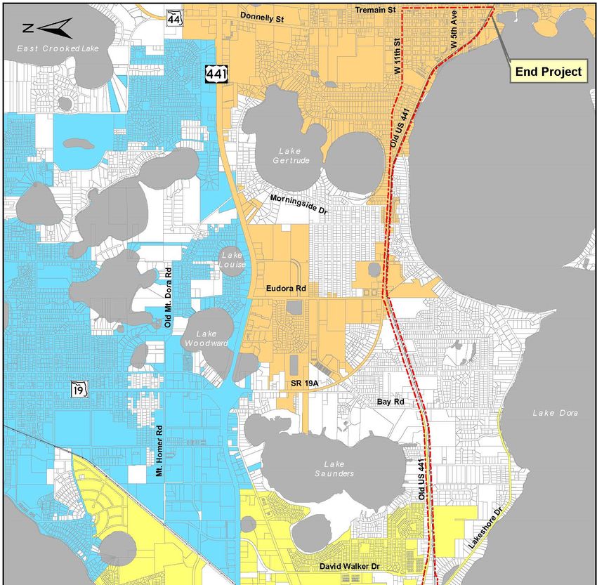
1 Report Purpose
This report documents the analysis of the proposed concepts for a shared use path (named
segment 5 of the Wekiva Trail) from Wooton Park in the City of Tavares to Tremain Street in the
City of Mount Dora. These planning concepts were evaluated by performing a review of existing
conditions, researching technical standards, and producing an evaluation matrix. This report
provides a summary of the study area planning concepts, stakeholder and public involvement
activities and the next steps for the study.

2 Introduction

2.1        Project Description
This study is being conducted by the Florida Department of Transportation (FDOT) – District Five
Office in coordination with the cities of Tavares and Mount Dora, Lake-Sumter Metropolitan
Planning Organization (MPO), Lake County Public Works Department, Lake County Office of
Parks and Trails, and the Lake County Transit Division. This study was initially named the
Tavares-Mount Dora Trail. In April 2020, at the request of the cities of Mount Dora and Tavares,
and Lake County, the name was changed to Wekiva Trail Extension-Segment 5 in order to signify
the relevance of this segment as part of the overall regional network. All documents prior to this
report include “Tavares-Mount Dora Trail” in the title, i.e. Tavares-Mount Dora Trail Corridor
Planning Study – Existing Conditions Report.

The study evaluates planning concept alignments for a shared use path included in the Lake
County Trails Master Plan (2018 update) as part of the regional Wekiva Trail and will connect the
cities of Tavares and Mount Dora along Old U.S. 441 or the CSX/Florida Central Railroad (FCEN)
railroad right of way. This trail will also provide a connection to the North Lake Trail Phase 1 and
Tav-Lee Trail to the west and Segments 1 through 4 of the Wekiva Trail to the east.

2.2        Study Area Description
The proposed shared use path will travel along a 5.5 to 6-mile corridor beginning at Disston
Avenue/Wooton Park in the City of Tavares and terminate at Tremain Street in the City of Mount
Dora and follow the Old U.S. 441 and/or the Florida Central Railroad right of way in between. The
study area is illustrated in Figure 1.

                                                                                                  1
Figure 1 | Study Area Map

                            2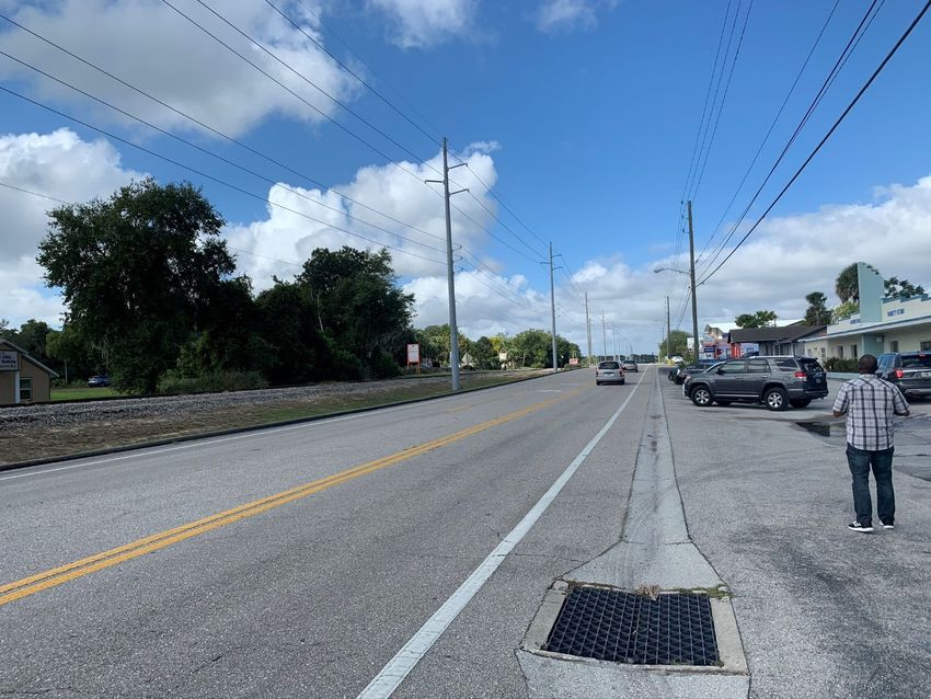
2.3          Study Approach
The study approach involved five steps including data collection and review of existing conditions, defining the purpose and need,
development of planning concepts, analysis and evaluation of concepts, and project wrap-up/ development of the corridor planning
study report. Activities included in each step are illustrated in Figure 2.

Figure 2 | Study Approach

PVT = Project Visioning Team
Note: The initial project schedule was delayed due to COVID-19 and the limitations of hosting an in-person public meeting.

                                                                                                                                3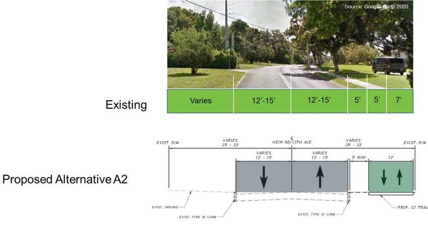
3 Purpose and Need
3.1 Purpose
The purpose of this project is to provide a safe, comfortable, and accessible multiuse trail facility
to safely accommodate bicyclists, pedestrians, and other non-motorized users of all ages and
abilities. The project will connect the cities of Tavares and Mount Dora and fill the gap in the
regional Wekiva Trail network and promote the recreational goals of the region.
3.2 Need for Improvement
The need for this project stems from two primary factors, which include:
Gaps in the regional trail network; and a
Lack of safe, comfortable, and accessible pedestrian and bicycle facilities.
Gaps in the Regional Trail Network
The Wekiva Trail Extension-Segment 5, also referred to as the Tavares-Mount Dora Trail, would
fill the network gap in the Wekiva Trail, by completing all five segments of the Wekiva Trail and
by extending the Wekiva Trail further west of Mount Dora to connect with existing Phase 1 Tav-
Lee Trail and the proposed North Lake Trail Phase 1 in Tavares. The proposed Wekiva Trail
Extension-Segment 5 would also provide connections to the proposed North Lake Trail, Sylvan
Shores Connector, the Golden Triangle YMCA proposed trailhead and the Mount Dora bicycle
network and trail system.
As documented in the Wekiva Trail Project Development and Environment (PD&E) Study
(prepared by the Lake-Sumter Metropolitan Planning Organization, completed in March 2016),
the design and construction of the Wekiva Trail is divided into the following segments (Figure 3):
Segment 1 is a 5.5-mile segment from Tremain Street in Mount Dora to State Road (S.R.)
46 in Sorrento;
Segment 2 is a 3-mile segment from S.R. 46 to Hojin Street in Sorrento;
Segment 3 is a 6.5-mile segment from Hojin Street in Sorrento to the Wekiva River; and
Segment 4 is a 6.3-mile Neighborhood Lakes Trail, that will connect the Wekiva Trail
starting at S.R. 46 to the future West Orange Trail in Kelly Park.
4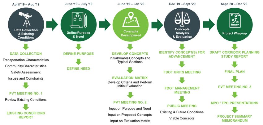
Figure 3 | Wekiva Trail Segments

Source: Wekiva Trail PD&E, Segment 1 Public Meeting, March 17, 2016, Summary Presentation.

The Wekiva Trail Extension-Segment 5 will provide an important connection that will complete the
regional trail network and provide a continuous multiuse trail facility to benefit non-motorized users
in Lake County.

Lack of Safe, Comfortable, and Accessible Pedestrian and Bicycle Facilities

Approximately 10 percent (10%) of the study area households do not own a vehicle. These
households are dependent upon bicycle and pedestrian facilities to travel between destinations.
There are no bicycle facilities, and sporadic sidewalks throughout the study area, with the
exception of a small segment at the east edge of the study area along Tremain Street. The lack
of continuous pedestrian and bicycle facilities within the study area offers few opportunities for
non-motorized travel between local destinations. Bicyclists and pedestrians currently utilize the
paved or unpaved shoulders to travel adjacent to motorized vehicles along Old U.S. 441. The
speed limits along Old U.S. 441 are primarily posted at 35 and 45 miles per hour (mph). Vehicles
along the roadway typically travel at much higher speeds, creating an unfriendly environment for
pedestrians and bicyclists. Additionally, there is approximately six percent (6%) truck traffic along
the corridor. Of the bicycle and pedestrian facilities that are present on connecting roadways,
there are limited Americans with Disabilities Act (ADA) compliant connections between
residences, community features, and conservation areas.

                                                                                                    5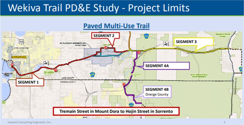
4 Traffic

4.1        Existing Year Volumes
The Annual Average Daily Traffic (AADT) for the study area is illustrated in Figure 4. The Old U.S.
441 corridor is a two-lane collector in an urban area from Disston Avenue to C.R. 19A. Along this
segment, the AADT was approximately 10,300 vehicles, according to FDOT 2018 AADT data.
Between C.R. 19A and Tremain Street, Old U.S. 441 is a minor arterial in an urban area with an
AADT of approximately 10,400 vehicles. Pedestrian and bicycle count data was not available
along the corridor; however, cyclists and pedestrians were observed along Old U.S. 441, primarily
in the downtown areas of Tavares and Mount Dora during field review.

Photo along Old U.S. 441 west of Lucerne Drive, facing west.

                                                                                                 6
Figure 4 | Annual Average Daily Traffic (AADT)
74.2 Existing Operational Analysis (LOS)
Level of Service (LOS) measures the travel delay of vehicles and provides a “grade” based on
the delay. LOS examples are shown in Figure 5. An “A” grade represents free flowing traffic, while
“F” is considered failing and highly congested. The LOS for Old U.S. 441 varies between LOS B
and LOS C, as illustrated in Figure 6. The corridor LOS were obtained from the Lake Sumter MPO
Transportation Management System (TMS).
Figure 5 | Level of Service Examples
The levels of service of the roadway segments within and adjacent to the study area are primarily
LOS B, with the following exceptions, which are LOS C:
Old U.S 441 from Eudora Road to Lakeshore Drive
S.R. 19A from Bay Road to U.S.441
Eudora Road from Old U.S. 441 to U.S. 441
Donnelly Street from W 5th Avenue to U.S. 441
8Figure 6 | Corridor Level of Service (LOS)
95 Planning Concept Analysis and Development
5.1 No Build Planning Concept
The No Build Planning Concept would result in no changes being made to the existing study area.
Under the No Build Planning Concept, Old U.S. 441 would remain as it exists today, and there
would not be any bicycle nor pedestrian facilities developed. Bicyclists and pedestrians would
continue to utilize the existing paved/unpaved shoulders and disconnected network of sidewalks
along Old U.S. 441 to travel adjacent to vehicular traffic.
The primary advantage of the No Build Planning Concept is that there would be no environmental
or drainage impacts from construction in wetland areas and drainage basins. It does not require
any capital, or expenditure of state/federal funds, and does not necessitate the acquisition of
additional railroad right of way, land or mitigation.
The disadvantages of the No Build Planning Concept are significant when compared to the Build
Planning Concepts, including:
Safety concerns with potential conflicts between higher-speed vehicular traffic and
pedestrians/cyclists traveling within close proximity will remain unaddressed.
Lack of safe, comfortable, and accessible pedestrian and bicycle facilities within the
area will remain unaddressed.
A six-mile gap within the regional trail network will remain unresolved.
The No Build Planning Concept provides baseline information by which other project planning
concepts may be compared throughout the concept selection process, which is further described
in Section 5.4. The No Build Planning Concept will be carried forward throughout the project
process with the recognition that it does not fulfill the study’s purpose and need.
5.2 TSM&O and Multi-Modal Planning Concepts
Transportation Systems Management and Operations (TSM&O) concepts are comprised of
various improvement options and are usually generated to achieve the maximum use and energy
efficiency of the existing facility. TSM&O planning concepts include activities designed to optimize
the performance and utilization of the existing infrastructure through implementation of systems,
services, and projects to preserve the capacity and improve security, safety, and reliability of the
roadway system.
Each of the proposed trail concepts, as described in Section 5.4, are focused on providing safe,
comfortable, and accessible bicycle and pedestrian facilities from Wooton Park in City of Tavares
to Tremain Street in the City of Mount Dora. The proposed improvements constitute a TSM&O
initiative. The proposed improvements also include multi-modal components, as each build
concept analyzes a corridor for bicyclists and pedestrians to travel between destinations within
the study area and ties into existing transit routes where present.
105.3 Design Criteria
The design of the Wekiva Trail Extension-Segment 5 should follow all proper design elements
for a trail with consideration given to the local area. Table 1 summarizes the design criteria for a
shared use path/trail based on the Cities of Mount Dora and Tavares and Lake County design
standards. Table 2 includes the design guidance for a shared use path based on the 2020
FDOT Design Manual (FDM), which sets forth geometric and other design criteria, as well as
procedures for FDOT projects.
Table 1 | Mount Dora, Tavares and Lake County Design Criteria
Design Element Urban Rural Source
Mount Dora
Regional shared-use trails were developed based on the Lake County Trails Network.
Regional shared-use trails are characterized by their interconnection to regional
destinations and other statewide trails. These trails are 12 to 15 feet in width and
consist of an asphalt or concrete surface.
Design speed 20 mph 20 mph
Paved Width
Desirable 15 ft 12 ft
Minimum 10 ft 10 ft
Minimum Radius 75 ft 30 ft
Horizontal Clearance to Obstacles
Desirable 4 ft 4 ft
Minimum 3 ft 3 ft
Minimum (with drop off) 6 ft 6 ft
Minimum Separation from Roadway
(distance to edge of shoulder) Outside
Desirable Clear Zone 5 ft
Mount Dora Trails
Minimum 5 ft 5 ft
Master Plan, Section 4.0
Vertical Clearance
– Design Standards
Desirable 10 ft 10 ft
Minimum 8 ft 8 ft
Shoulder Width (Grassed) 2 ft 2 ft
Horizontal Curve Radius
Desirable 100 ft 100 ft
Minimum with proper signing 36 ft 36 ft
Profile Grade
Desirable < 5% < 5%
Maximum (with restricted lengths) 11% 11%
Maximum change in grade without vertical curve 4% 7%
Minimum base clearance above design high water
1 ft 1 ft
elevation
Minimum pavement cross slope 0.02 0.02
Community paths and trails connect homes to the larger trail network. These walkways
are 8 to 10 feet in width and consist of an asphalt or concrete surface.
11Design Element Urban Rural Source
Urban Bicycle and Pedestrian Corridor - The design standards for these types of facilities
are outside the scope of this Master Plan and should be developed for individual projects
based on the cited references, engineering judgment, and local preferences.
Tavares
Not available. Refer to Lake County Design Standards.
Lake County
Width
Generally, 12.5 feet wide or more.
15 feet is the recommended width.
Lateral Clearance
The minimum lateral clearance distance is two feet.
The MUTCD requires three feet clear between trail and signage.
Overhead Clearance
The recommended overhead clearance for structures is 10 ft, with a minimum of 8 ft.
Trees will be limbed up thirteen feet above the trail surface.
Striping
Lake County Office of
Striping may be installed where passing is inadvisable, including at the approach and
Parks and Trails Master
departure of intersections. Striping may also be advisable where trail user volume is
Plan, Vol II, Trails,
high, sight distance is restricted, or design speed is low.
Section 9 – Trail System
Cross slope
Design Standards
Shared use paths adjacent to roadways function as sidewalks according to PROWAG
and therefore cannot have a cross slope greater than 2%.
A 1% cross-slope is recommended for ease of use by people with disabilities.
Grade
The maximum grade of a shared use path adjacent to a roadway is 5%.
Grades for paths in an independent right-of-way should not exceed 5%.
Switchbacks and pull-outs can be provided to mitigate excessive grade changes.
Signage should also be provided to warn users of grade changes.
More geometric design criteria detail can be found in the AASHTO Guide for the
Development of Bicycle Facilities.
12Table 2 | Design Criteria
Design Element Criteria Source
Widths
Two-Directional Shared Use Path
Range 10-14 ft
Standard 12 ft FDM, Section 224.4
Shared-Use Nonmotorized (SUN) Trail Network Facilities
Less than 12 ft Chief Planner's Approval Required
SUN Trail Network Facilities (N/A)
Limited R/W 10 ft
Constrained
8 ft
Conditions
*Consider accommodation of emergency & maintenance vehicles
/ management of steep grades when selecting width.
*FHWA's Shared Use Path Level of Service Calculator may be
used as a guide in determining appropriate width.
Cross Slopes
Maximum Cross Slope
0.02
(ADA Requirements)
FDM, Section 224.5
Changing Slope Use 75 ft distance to transition from -2% to 2% OR 2% to -2%
Direction of Path *Consider potential for ponding water
Longitudinal Slopes
Maximum Slope (ADA
0.05
Requirements)
Ramp >5% FDM, Section 224.6
8.33% with a maximum rise of 30 inches with a level landing at
Max Ramp Slope
least 60 inches in length
Ramp Maximum Grade Grade (%) Length (ft)
6 800
7 400
8 300
FDM, Table
9 200 224.6.1,
10 100 *Refer to FDM
+11 50 224.11 for controls
on grade changes
1) When using a longer grade, consider adding 4 to 6 ft of
additional width to path to allow a bicyclist to dismount and
walk their bicycle.
2) Clear Distances and sight distances should be adjusted to
accommodate longer grades.
13Design Element Criteria Source
Horizontal Clearance
Adjacent to
4 ft (including placement of signs)
both sides of path
Max Slope adjacent to
1:6
both sides of path
Graded Area Width FDM, Section 224.7
2 ft
Restricted Conditions
(bridge abutments,
signposts, fencing, Within 4 ft of the edge of pavement; not less than 2 ft
railing)
Vertical Clearance
Bottom of lowest edge
of an overhead
obstruction to any 10 ft
portion of path under
FDM, Section 224.8
obstruction
Overhead Signs/ Other
obstructions under 8 ft
constrained conditions
Accommodation of
equestrians /
12 ft
maintenance and
emergency vehicles; *FDM 260.6 for
bridge structure
Underpasses and
*Existing elements that provide a minimum 8 ft minimum clearance
tunnels;
vertical clearance are not required to be corrected to
the clearances listed above.
SUN Trail
Design Speed
Longitudinal Grade ≤
18 mph
4%
FDM, Section 224.9
Longitudinal Grade >
30 mph
4%
Maximum Radii
Horizontal Curves Design Speed Cross Slope Maximum Radius
18 mph 2% 74 ft
18 mph -2% 86 ft FDM, Section
30 mph 2% 261 ft 224.10, Table
224.10.1
30 mph -2% 316 ft
*For paths with two-way traffic use minimum radius given for cross
slope of -2%
14Design Element Criteria Source
Stopping Sight Distance
Flat Grades Design Speed Grade FDM, Section
18 mph 134
224.10, Table
30 mph Use 18 mph Values 224.10.2
Vertical Alignment
When S>L
When SDesign Element Criteria Source
Drop-off Hazards
Shielding Severity
See FDM, Figure 224.15.1
Condition 1
Shielding Severity
See FDM, Figure 224.15.1
Condition 2
1) The engineer should consult the District Bicycle/Pedestrian
Coordinator or Trail Coordinator regarding pedestrian and cyclist
traffic and their routes.
2) Installing fencing or railings are two ways to shield the drop-offs.
Fencing is generally intended for use in rural areas along paths
and trails. Railing is generally intended for urbanized areas,
locations attaching to bridge rail or along concrete walkways.
Pedestrian/Bicycle Railings (Standard Plans, Index 515 Series)
are adequate for shielding all drop-offs but are generally intended
for use on drop-offs greater than 60 inches. Pipe Guiderail FDM, Section
(Standard Plans, Index 515-070 and 515-080) is adequate for 224.15
Shielding for Severity
shielding drop-offs which are 60 inches or less.
Conditions other than
3) Along continuous sections where the drop-off varies above and
Cases 1 or 2
below the 60-inch threshold, for uniformity the engineer may
consider using only one of the railing types adequate for shielding
all drop-offs.
4) Railing or fencing near intersections or driveways could obstruct
the driver's line of sight. To reduce the need for railings, as a
sidewalk or shared use path approaches an intersection, consider
extending cross drains and side drains to minimize drop-offs.
5) The installation of fencing, railing, or pipe guardrail presents a
hazard in and of itself. Evaluate whether or not the installation of
these devices present a greater risk than the drop-off or other
condition it is intended to shield.
SJRWMD
Environmental Resource Permit (ERP) should be obtained if trail
FDM, Drainage
construction impacts are not exempt or above the permit
Design Guide
thresholds for the water quantity, water quality, and wetlands.
Drainage
National Pollutant
Storm water Pollution Prevention Plan (SWPPP) should be
Discharge
developed and submitted.
Elimination System
(NPDES)
Path Railings
FDM, Section
Requirements for railings and fences are discussed in FDM 222.4.
224.16
Typical Sections
FDM, Section
Example typical sections are provided in FDM 306.
224.17
16Design Element Criteria Source
Pavement Design
FDM, Section
See the FDOT Pavement Management website for guidance on pavement requirements.
224.17.1
Shade Considerations
Shade along shared use paths is desired. Consider shade from landscaping and shade from
architectural sources such as buildings, pavilions, and shade sails. To maximize shade and
minimize costs:
• Begin coordination between the designer, project manager, utilities, district landscape
architect, and the landscape’s maintaining agency during Phase I of the design. FDM, Section
• Choose an alignment of the path that can capitalize on shade from existing and proposed 224.18
trees or architectural sources.
For more information on shade from Landscape Design, refer to FDM 228, FDM 329 and
Work Program Instructions Part 3, Chapter 16.
175.4 Build Concepts
Three planning concepts were identified for the proposed shared use path as described below.
Concept A-1 includes a shared use path that generally follows the Old U.S. 441 corridor.
The path crosses over to the residential area near the Heron Cay Bay and Breakfast Inn
(east of Old U.S. 441) and transitions to East 8th Avenue. The trail then transitions to
Tremain Street in the Mount Dora Historic District and continues south, terminating where
Tremain Street meets the railroad.
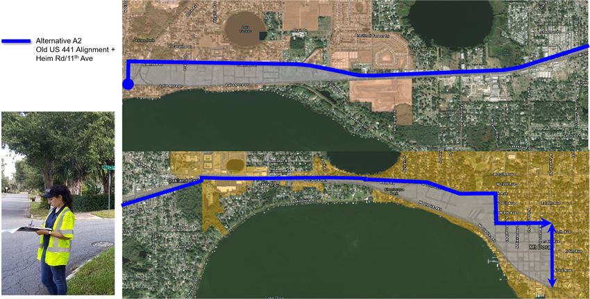
Concept A-2 includes a shared use path that generally follows the Old U.S. 441 corridor
to Heim Road/West 11th Avenue. The path then follows Helen Street, to West 8th Avenue
and transitions to Tremain Street in the Mount Dora Historic District. The trail then
continues south, terminating where Tremain Street meets the railroad.
Concept B includes a shared use path within the existing railroad right of way.
5.4.1 BUILD CONCEPTS ALIGNMENT AND TYPICAL SECTIONS
The following section provides an overview of each build concept, included in Appendix A.
5.4.1.1 Planning Concept A-1
The first segment of Concept A-1, as depicted in Figure 7, begins at Main Street and Disston
Avenue in Tavares, continues along Disston Avenue to Alfred Street, and terminates at the
intersection of Old U.S. 441 and Heim Road/West 11th Avenue. As depicted in Figure 8, this
segment maintains the existing 12-foot travel lanes (shaded in gray) and includes a 12-foot multi-
use trail (shaded in green). The proposed trail would be located on the south side of Old U.S. 441
and faces challenges such as the location of utility poles and a drainage culvert.
The trail then continues east to the intersection of Old U.S. 441 and Eudora Road, and crosses
over to the north side of Old U.S. 441, to just west of the Old U.S. 441 and Heim Road intersection.
As depicted in Figure 9, the segment includes a 10-foot cycle track1 (shaded in yellow) within the
existing road on the north side of Old U.S. 441, and two 11-foot travel lanes (shaded in gray). The
proposed cycle track is separated from the travel lanes by a 7-foot median. Because this segment
is within the right of way, there are no anticipated environmental impacts at this stage of the study.
The trail then continues south, along the north side of Old U.S. 441, to an existing public path at
the Heron Cay Bed and Breakfast, which connects Old U.S. 441 to Helen Street and then turns
east onto West 8th Avenue. As depicted in Figure 10, this segment includes reduced travel lanes
from 12-feet in each direction to 11-feet in each direction (shaded in gray) and an 8.5-foot sidewalk
(shaded in beige) on the north side of Old U.S. 441.
Concept A-1 terminates at the Tremain Street Trailhead and includes an extension of the existing
cycle track to tie into the existing trailhead. The proposed cycle track would extend from Charles
Avenue to W. 5th Avenue as depicted in Figure 11, and would include a single 12-foot northbound
travel lane (shaded in gray), and a two-way cycle track (shaded in yellow).
1
A two-way cycle track (also known as a protected bike lane) is a physically separated track that allows
bicycle movement in both directions on one side of the road.
18Figure 7 | Planning Concept A-1 Alignment
Concept A-1
MATCHLINE A
Typical
Section A-A
Typical
Section B-B
MATCHLINE A
Typical
Section C-C
Typical
Section D-D
19Figure 8 | Planning Concept A-1 Typical Section A-A
12-foot Shared-Use Path along Old U.S. 441 from Disston Avenue to Golden Isle Drive.
Proposed Concept A-1
20Figure 9 | Planning Concept A-1 Typical Section B-B
10-foot Cycle Track with 7-foot separator along Old U.S. 441 from Eudora Road to Heim Road
Proposed
Concept A-1
21Figure 10 | Planning Concept A-1 Typical Section C-C
8.5-foot Sidewalk along Old U.S. 441 from Heim Road to Helen Street/W 8th Avenue
Proposed Concept A-1
22Figure 11 | Planning Concept A-1 Connector Alignment Typical Section D-D
10-foot Two-Way Cycle Track along Tremain Street from Charles Avenue to 5th Avenue
235.4.1.2 Planning Concept A-2
The first two segments of Concept A-2, from Wooton Park at the intersection of Main Street and
Disston Avenue to the intersection of Old U.S. 441 and Heim Road, are the same as in Concept
A-1, as depicted in Figure 12.
Concept A-2 picks up at the Old U.S. 441 and Heim Road intersection and continues east along
Heim Road, then travels along the south side of Heim Road as a 12-foot trail, turns south along
Helen Street and then east along West 8th Avenue. As depicted in Figure 13, the roadway shaded
in gray remains the same, with a new 12-foot multi-use trail on the south side (shaded in green).
The trail would replace the existing sidewalk.
Similar to Concept A-1, Concept A-2 terminates at the Tremain Street Trailhead and includes an
extension of the existing cycle track to tie into the trailhead.
24Figure 12 | Planning Concept A-2 Alignment
Concept A-2
MATCHLINE A
Typical
Section A-A
Typical
Section B-B Typical
Section E-E
MATCHLINE A
Typical
Section D-D
25Figure 13 | Planning Concept A-2 Typical Section E-E
12-foot Shared-Use Path along Heim Road from Old U.S. 441 to Helen Street
Proposed Concept A-2
265.4.1.3 Planning Concept B
As depicted in Figure 14, Concept B includes a 14-foot wide trail within the existing CSX Railroad
right of way along Lake Dora Drive, replacing the existing railroad tracks. The CSX Railroad is
currently being used for rail car storage.
The proposed trail along the section of Lake Dora Drive from Disston Avenue to Dora Avenue
runs down the center of roadway. As shown in Figure 15, the existing CSX Railroad would be
replaced by the trail (shaded in green).
The remainder of Concept B travels within the existing CSX Railroad right of way and parallels
the Old U.S. 441 corridor. Concept B terminates at Tremain Street. As shown in Figure 16, the
14-foot trail (shaded in green) would remain within the CSX Railroad right of way throughout the
entire segment.
27Figure 14 | Planning Concept B Alignment
Concept B
Typical
Section B-B
MATCHLINE A
Typical
Section A-A
MATCHLINE A
28Figure 15 | Planning Concept B Typical Section A-A – 14-foot Trail
Within CSX Railroad from Disston Avenue to Dora Avenue.
29Figure 16 | Concept B Typical Section B-B
14-foot Trail within CSX Railroad from Dora Avenue to Tremain Street.
305.5 Initial Concepts Comparison and Matrix
The evaluation criteria were developed based on the study goals and objectives for the Wekiva
Trail Extension-Segment 5 Corridor. These criteria address socioeconomic characteristics,
cultural and natural resources, physical characteristics, trail experience, traffic operations and
safety, and project cost estimates to capture the development of the project. In addition, the
criteria examine the qualitative factors such as community support and the continual support from
maintaining municipalities. The following comparative evaluation examines each criterion and
summarizes the assessment conducted for each concept. The evaluation process used these
criteria to determine recommended corridors to be carried forward to the next phase of the project.
5.5.1 SOCIAL & ECONOMIC EVALUATION
5.5.1.1 Consistency with Local Plans
A review of local transportation plans was performed to demonstrate the consistency of this
project with regional and local transportation planning efforts. A summary of the project’s
consistency is provided below in Table 3, and the full analysis is documented in the Wekiva Trail
Extension-Segment 5 (Tavares-Mount Dora Trail) Corridor Planning Study: Existing Conditions
Report. The consistency with local plans is the same for each concept.
Table 3 | Consistency with Local Plans
Consistent
Agency Applicable Standard with Source
Project
Objective VII-1.5 Trails and Lake County
Greenways, references development Comprehensive Plan,
of a comprehensive greenway, Planning Horizon 2030
blueway, trails, equestrian and (updated March 2018)
bikeway system
Policy VII-1.5.1 Greenways and
Blueways, references coordination of
Lake County establishing and maintaining Yes
greenway and blueway trails
The Tav-Dora Trail is included in the Lake County Trails
Lake County Trails Master Plan as Master Plan (updated
part of the County’s master trail September 2018)
system, to eventually connect to the
regional and state trail systems.
Identifies the Tav-Dora Trail Study
Lake-Sumter Lake-Sumter MPO List
(Wekiva Trail Extension-Segment 5) Yes
MPO of Priority Projects
for a new trail.
31Consistent
Agency Applicable Standard with Source
Project
Mount Dora
Transportation Element Policy 5.e.,
Comprehensive Plan
references future pedestrian and bike
2032 (updated June
paths, per the City's Trails Master
2018)
Plan.
Conservation Element Policy 2.k.,
City of Mount references promoting public access Yes
Dora to lakes through the use of
pedestrian paths, trails or walkways.
The Florida Central Railroad right of Mount Dora Trails
way is identified in the Trails Master Master Plan (April
Plan for future acquisition for a trail. 2009)
Objective 2-1.1, references providing
Safe, Convenient, and Efficient
Multimodal Transportation system
utilizing roads, trails, rail, water and
air as transportation mediums.
Objective 2-1.5 Pedestrian/Bicycles,
references promoting a System of Tavares
City of Bicycle and Pedestrian Ways in Comprehensive Plan
Yes
Tavares Planning for Transportation Facilities. (updated December
Policy 2-1.5.2 Tav-Lee Trail, 2011)
references coordination with Lake
County to analyze the feasibility of
acquiring abandoned railroad right of
ways within the City for use as
regional bicycle and pedestrian
paths.
5.5.1.2 Maintaining Agencies and Community Support
Support from the maintaining agencies and local communities are integral components to the
success of a trail concept. Each of the three maintaining agencies are in support of the Wekiva
Trail Extension-Segment 5 and are in discussions with CSX to negotiate use of the railroad right
of way for the trail segment. Their support for each concept is shown in Table 4. The degrees of
support (low/medium/high) were determined based on feedback and discussion from stakeholders
and community representatives at the Project Visioning Team meetings and the Virtual Public
Meeting, which are further described in Section 6.1 and in the Public Involvement Plan.
The Wekiva Trail Extension-Segment 5 study area has a population of approximately 20,500
people and over 8,868 households based on the 2017 American Community Survey (ACS) data.
Support for the Wekiva Trail Extension-Segment 5 Corridor by the community within the study
area is analyzed for each concept based on degree of support as shown in Table 4.
32Table 4 | Maintaining Agencies & Community Support
Concept A-1 Concept A-2 Concept B
Evaluation Criteria
(Old U.S. 441) (Heim Rd/11th Ave) (Railroad)
Maintaining Municipalities Low Low High
Community Support Low Low High
5.5.1.3 Right of Way Impacts
The total acreage of right of way impacts within the study area are identified in Table 5 for each
concept. No relocations are anticipated with any of the concepts. The impacted right of way
includes primarily privately-owned lands.
The right of way impacts for Concept B are pending discussion with CSX Transportation, which
is currently under negotiation with the Cities of Mount Dora and Tavares and Lake County.
Table 5 | Potential Right of Way Impact(s)
Concept A-1 Concept A-2 Concept B
Evaluation Criteria th
(Old U.S. 441) (Heim Rd/11 Ave) (Railroad)
Total Parcel Impact(s) 8 8 8
Private 7 7 8
Public 1 1 0
Total Acres of Impact(s) 1.00 1.00 42.43
Private 0.97 0.97 42.43
Public 0.03 0.03 0.00
5.5.1.4 Community Facilities
The community services and social resources within the study area are displayed in the Existing
Conditions Report, Figure 27, available under a separate cover. A synopsis of the resources
present within the study area are shown in Table 6. The potential connectivity to social and cultural
resources is similar for each concept.
33Table 6 | Summary of Social Resources in the Study Area by Concept
Concept A-1 Concept A-2 Concept B
Evaluation Criteria
(Old U.S. 441) (Heim Rd/11th Ave) (Railroad)
Parks and Recreational Facilities 6 6 6
Schools 2 2 2
Churches and Religious Institutions 7 7 7
Fire and Police 5 5 5
Medical and Emergency Operation
0 0 0
Facilities
Other Public Buildings and Facilities 3 3 3
Other Significant Locations1 7 7 7
TOTAL 30 30 30
1. Chambers of Commerce, Shopping Centers and Hotels
5.5.2 CULTURAL RESOURCES EVALUATION
5.5.2.1 Historic and Archaeological Resources
Section 106 of the National Historic Preservation Act (NHPA) requires that historic and
archaeological resources be considered in project planning for federally funded or permitted
projects. Cultural resources or historic properties include any, “prehistoric or historic district, site,
building, structure, or object included in, or eligible for inclusion in the National Register of Historic
Places (NRHP).”
There is one historic district and four individual sites that have been added to the National Register
of Historic Places within the study area. Designated on October 1, 2009, the Mount Dora Historic
District (NRHP #09000777) encompasses the historic downtown of Mount Dora. Roughly
bounded by 3rd Avenue, 11th Avenue, Clayton Street, and Helen Street, the 230-acre district was
added to the National Register of Historic Places for areas of significance including Architecture,
Community Planning and Development, Commerce and Exploration/Settlement between 1877
and 1959.
It features 565 contributing and 146 non-contributing resources. Three contributing resources
were previously listed as individual sites in the National Register:
Atlantic Coast Line Railroad Station (NRHP #92000099) – 341 Alexander Street
John P. Donnelly House (NRHP #75000560) - 530 Donnelly Street
Lakeside Inn (NRHP #87000481) - 100 North Alexander Street
In addition to the resources identified in Mount Dora, the Harry C. Duncan House (NRHP
#97000860) at 426 Lake Dora Drive in Tavares is listed in the National Register of Historic Places
and located within the study area. Furthermore, a Cultural Resource Assessment Survey (CRAS)
for the Wekiva Trail Project Development and Environment (PD&E) Study east of Tremain Street
34was prepared for the Florida Department of Transportation (FDOT) in November 2012. The
objective of this survey was to identify cultural resources within the project area of potential effect
(APE) and assess their eligibility for listing in the National Register of Historic Places (National
Register) according to the criteria set forth in 36 CFR Section 60.4.
This CRAS identified the CSX / Seaboard Coast Line Railroad (8LA2957) corridor as being
eligible for inclusion in the National Register in the areas of Transportation and Commerce.
According to the Historic Railroad Resources of Florida Multiple Property Submission (MPS)
cover nomination prepared in 2001, a railroad resource must “retain their historic appearance to
a high degree.” This would include its historic appearance and existence of significant railroad
elements, including the tracks and ties. These sites are shown in the Existing Conditions Report,
Figure 26. A comparison of the number of properties containing known historic or archaeological
resources within 50 feet of the study area are summarized in Table 7.
Table 7 | Cultural Resources Concepts Comparison
Concept A-1 Concept A-2 Concept B
Evaluation Criteria th
(Old U.S. 441) (Heim Rd/11 Ave) (Railroad)
State Historic Preservation Office
Structures
437 / 34 437 / 34 437 / 34
Number / Eligible or Potentially
Eligible for listing in NRHP
State Historic Preservation Office
Bridges
1/1 1/1 1/1
Number / Eligible or Potentially
Eligible for listing in NRHP
State Historic Preservation Office
Cemeteries
0/0 0/0 0/0
Number / Eligible or Potentially
Eligible for listing in NRHP
State Historic Preservation Office
Sites
0/0 0/0 0/0
Number / Eligible or Potentially
Eligible for listing in NRHP
Total
Number / Eligible or Potentially 438 / 35 438 / 35 438 / 35
Eligible for listing in NRHP
5.5.2.2 Section 4(f)
Section 4(f) refers to a portion of the Department of Transportation Act of 1966, now known as 23
U.S.C. § 138 and 49 U.S.C. § 303, which “governs the use of publicly owned parks, recreation
areas, wildlife and waterfowl refuges, and public or private historic sites for U.S. DOT
transportation projects.” These resources are typically referred to as Section 4(f) resources or
properties (FDOT PD&E Manual 2019).
The Wekiva Trail Extension-Segment 5 is anticipated to have Section 4(f) impacts, due to the
35proximity of each of the trail concepts to historic sites located within a quarter mile of each trail
concept, which may incur de minimis impacts to the properties.
According to a November 2013 Wekiva Trail PD&E Study Cultural Resources Section 106 Effects
Consultation Case Study Report prepared for FDOT, the CSX / Seaboard Coast Line Railroad
(8LA2957) segment being evaluated in the Concept B alignment, was determined to be eligible
for inclusion in the National Register. In addition, the Railroad Bridge over Oakland Drive, may be
considered a contributing resource to the Seaboard Coast Line Railroad (8LA2957).
According to the Historic Railroad Resources of Florida Multiple Property Submission (MPS)
cover nomination prepared in 2001, a railroad resource must “retain their historic appearance to
a high degree.” The railroad segment parallel to Old U.S. 441 continues to exhibit its historic
appearance and the significant railroad elements remain, including the tracks and ties. Though
the portion of the railroad no longer serves its historic purpose, it still retains historical importance
for its role in the development and transportation in the area. This portion of the CSX / Seaboard
Coast Line Railroad was determined eligible for inclusion in the National Register in the areas of
Transportation and Commerce. The removal of the resource’s essential materials, including the
rails and ties, would constitute an adverse effect. Although the route will continue to be evident,
as the new trail will not deviate from the railroad corridor, the railroad’s integrity will be
compromised by the loss of materials.
In addition, there are several public parks, boat ramps, and conservation lands located within 0.25
mile of the corridor, as listed below.
Lakeside Inn
Donnelly, Annie E Park
Seaboard Coast Line RR Grade
Riley’s Park Resource Group (mobile home park)
Mount Dora Historic District
5.5.3 NATURAL RESOURCES EVALUATION
5.5.3.1 Wetlands
Wetlands are protected under Executive Order 11990, “Protection of Wetlands.” There are rivers,
marshes and lakes located near the study area. The presence of surface waters increases the
occurrence of wetlands. Desktop analysis of National Wetlands Inventory data and field visits
were used to identify wetlands. Potential wetland impacts resulting from each concept are
compared in Table 8.
Table 8 | Wetland Impacts
Concept A-1 Concept A-2 Concept B
Evaluation Criteria th
(Old U.S. 441) (Heim Rd/11 Ave) (Railroad)
Acreage of Potential Wetland
0.16 0.16 0.60
Impacts
36Direct wetland impacts can be minimized through use of a gravity wall or similar drainage
modification. Indirect impacts include introduction of potential pollutants, increased runoff, a higher
probability of ponding, and fluctuating water level elevations as a result of the trail improvements.
The severity of each impact should be considered. Any indirect impact should comply and align
with any applicable ordinances or proposed conservation or developmental plans set forth by the
St. Johns Water Management District, particularly regarding the Ocklawaha and Middle St. Johns
basins.
5.5.3.2 Floodplains
Protection of floodplains is required by Executive Order 11988, "Floodplain Management",
USDOT Order 5650.2, "Floodplain Management and Protection," and Federal Aid Policy Guide
23 CFR 650A. Floodplains were identified using Federal Emergency Management Agency maps
and geographic information system (GIS) data. The proposed concept alignments are in/adjacent
to the 100-year and 500-year floodplain in several locations along the corridor. A comparison of
the floodplain impacts from each trail concept are summarized in Table 9.
Table 9 | Floodplain Impacts
Concept A-1 Concept A-2 Concept B
Evaluation Criteria th
(Old U.S. 441) (Heim Rd/11 Ave) (Railroad)
Acreage of Potential Floodplain
0.30 0.30 0.71
Impacts
Any fill of floodplain occurring with this project between the Seasonal Highwater Level (SHWL)
and the floodplain elevation will require floodplain compensation. No net encroachment into the
floodplain is allowed between the SHWL and the floodplain elevation.
5.5.3.3 Outstanding Florida Waters / Aquatic Preserves
There are no Outstanding Florida Waters within the study area. No impacts to the Outstanding
Florida Waters are anticipated with any of the proposed build concepts.
5.5.3.4 Wild and Scenic Rivers
There are no wild and scenic rivers present in the study area and no impacts are anticipated with
any of the proposed build concepts.
5.5.3.5 Wildlife and Habitat
Information regarding the primary wildlife and plant species are referenced in Table 10 and Table
11. Species were identified utilizing the Florida Geographic Data Library and their protection
status was obtained from the Florida Fish & Wildlife Conservation Commission and the
Environmental Protection Agency (EPA).
Direct impacts to protected species are not known at this time. Habitat fragmentation is
categorized as a low risk for all concepts because the trail would extend adjacent to or within
existing barriers rather than developing/clearing a new path through the forest.
37Table 10 | Wildlife in Study Area
Wildlife Species Federal or
Scientific Name Protection Status
Common Name State Listing
Aphelocoma
Florida Scrub-Jay Federal Threatened
Coerulescens
Red-cockaded
Picoides borealis Federal Endangered
Woodpecker
Wood Stork Mycteria americana Federal Threatened
Drymarchon corais
Eastern Indigo Snake Federal Threatened
couper
Sand Skink Neoseps reynoldsi Federal Threatened
Manatee Trichechus Threatened Marine
West Indian Federal
manatus Animal
Table 11 | Plant Species in Study Area
Federal or
Plant Species Scientific Name Protection Status
State Listing
Britton's Beargrass Nolina brittoniana Federal Endangered
Florida Bonamia Bonamia grandiora Federal Threatened
Lewton's Polygala Polygala lewtonii Federal Endangered
Cucurbita Federal
Okeechobee Gourd Endangered
okeechobeensis ssp.
Papery Whitlow-Wort Paronychia chartacea Federal Threatened
Pigeon Wings Clitoria fragrans Federal Threatened
Pygmy Fringetree Chionanthus pygmaeus Federal Endangered
Eriogonum longifolium Federal
Scrub Buckwheat Endangered
var. gnaphalifolium
Scrub Plum Prunus geniculata Federal Threatened
Wide-Leaf Warea Warea amplexifolia Federal Endangered
5.5.3.6 Coastal Zone Consistency / Coastal Barrier Resources
The National Coastal Zone Management Program, administrated by the National Oceanic and
Atmospheric Administration (NOAA), is a voluntary partnership between the federal government
and coastal states and territories that works to address some of today’s more pressing coastal
issues. Lake County is not subject to the National Coastal Zone Management program.
385.5.4 PHYSICAL CHARACTERISTICS EVALUATION
5.5.4.1 Air Quality
There are no expected air quality impacts resulting from the project. Lake County is currently
designated as being in attainment for the following Clean Air Act National Ambient Air Quality
Standards (NAAQS): ozone, nitrogen oxide, particulate matter (2.5 microns in size and ten
microns in size), sulfur dioxide, carbon monoxide, and lead.
5.5.4.2 Noise
There are no expected adverse noise impacts to the study area. Noise mitigation efforts are not
anticipated.
5.5.4.3 Potential Contamination
EPA data helped to identify contaminated locations within the study area. Existing Conditions
Report, Figure 28 identifies locations of known contaminated sites within 500 feet of all concepts.
For each concept, the degree of risk (low/medium/high) was determined based on the known
criteria and proximity to potentially contaminated sites. All concepts were determined to have
a low potential for contamination because they are not expected to have direct impacts to any
contaminated facilities.
5.5.4.4 Utilities
Several utility services are located in the study area as summarized in Table 1 in the Existing
Conditions Report. The exact number of utilities impacted by each concept has not yet been
determined; however, based on the utilities location along both sides of Old U.S. 441 and the
railroad right of way, it is expected that Concepts A-1 and A-2 would have greater utility impacts than
Concept B. A comparison of the utility impacts from each concept are summarized in Table 12.
Table 12 | Utility Impacts
Concept A-1 Concept A-2 Concept B
Evaluation Criteria th
(Old U.S. 441) (Heim Rd/11 Ave) (Railroad)
Level of Utility Impacts Moderate High Low
5.5.4.5 Drainage
A comparison of the drainage impacts from each trail concept are summarized in Table 13.
Conveyance must be maintained in all existing swales, and storage that is impacted by the
proposed trail must be compensated for within the basin. Storm structures that are impacted must
be replaced to maintain existing drainage patterns.
39Table 13 | Drainage Impacts
Concept A-1 Concept A-2 Concept B
Evaluation Criteria
(Old U.S. 441) (Heim Rd/11th Ave) (Railroad)
Level of Drainage Swale Impacts High Moderate Moderate
Drainage Swale Impacts
Concepts A-1, A-2 and B have the potential for existing drainage swale impacts. Concepts A-1
and A-2 have the potential to impact existing swales from Merry Road to Eudora Road. Concept
A1 has the potential to impact existing swales 300’ south of Heim Road/11th Avenue to 520’ south
of Heim Road/11th Avenue and Concept A2 consists of widening an existing sidewalk where no
swales exist currently.
Concept B can potentially impact the swales on the south side of Old U.S. 441 from Merry Road
to W-2 and from Poinsettia Drive to 300’ south of Heim Road/11th Avenue. The potential impact
to swales under Concept B continues to the end of the project.
Drainage Structure Impacts
Each concept has the potential to impact existing drainage structures. If any of the proposed
concepts are constructed, cross-drains will need to be extended.
Concepts A-1 and A-2 could potentially impact existing drainage structures on the south side of
Old U.S. 441 from Merry Road to Eudora Road. Concepts A-1 and A-2 include a cycle track
between Eudora Road and Heim Road/11th Avenue. If adding a raised median to separate the
cycle track from the travel lanes blocks existing stormwater flow, the median may need to be
slotted or drainage structures will need to be added to maintain existing drainage patterns.
Concept A-1 includes potential drainage structure impacts along 8th Avenue, while Concept A-2
includes potential drainage structure impacts along Heim Road/11th Avenue, Helen Street and
8th Avenue.
Concept B could impact existing drainage structures on the south side of Old U.S. 441 from Merry
Road to 5th Avenue. It is deemed that Concepts A-1, A-2 and B have the same level of drainage
structure impacts. Potential drainage structure impacts may be avoided by reducing the width of
the trail.
5.5.4.6 Culvert Modifications
Stormwater runoff is conveyed east from Merry Road to a 2’ X 2’ box culvert identified beneath
Old U.S. 441, 700’ west of Bay Road. In order to accommodate the runoff from the paved trail
along Old U.S. 441, the crossing culvert under is anticipated to be either extended, modified or
replaced.
40You can also read