WEST END STAGE 1 PUBLIC DOMAIN PLAN - NEWCASTLE CITY COUNCIL PREPARED FOR - City of Newcastle
←
→
Page content transcription
If your browser does not render page correctly, please read the page content below
WEST END STAGE 1
PUBLIC DOMAIN PLAN

PREPARED FOR

NEWCASTLE CITY COUNCIL
07 AUG 2017
SECOND DRAFT
© Urbis 2017

This publication is subject to copyright. Except as permitted under
the Copyright Act 1968, no part of it may in any form or by any means
(electronic, mechanical, photocopying, recording or otherwise) be
reproduced, stored in a retrieval system or transmitted without prior
written permission. Enquiries should be addressed to the publishers.

URBIS.COM.AU
CONTENTS

1.0 INTRODUCTION                      4
1.1   PROJECT BACKGROUND                  4
1.2   VISION                              4   4.0 PUBLIC DOMAIN
1.3   STRATEGIC POSITIONING               6
                                                  MASTER PLAN &
2.0 SITE ANALYSIS &                               FRAMEWORK                        28
                                              4.1   WEST END STAGE 1 – PUBLIC DOMAIN
    CONTEXT                           8       4.2
                                                    STRATEGIC DIRECTION
                                                    ACCESS & MOVEMENT FRAMEWORK
                                                                                     28
                                                                                    30
2.1   SITE HISTORY                        8
                                              4.3   STREET TYPOLOGIES                31
2.2   SITE CONTEXT                    10
                                              4.4   KEY PUBLIC SPACES & PLACES
2.3   PHOTOGRAPHIC AUDIT              12
                                                    FRAMEWORK                       32
2.4   SITE ANALYSIS OBSERVATIONS      16

3.0 DESIGN DIRECTION 22                       5.0 DESIGN ELEMENTS 48
                                              5.1   LIGHTING                        49
3.1   BIG IDEAS                       22
                                              5.2   GREEN SPACE                      51
3.2   DESIGN STRATEGIES & OPPORTUNITIES
                                              5.3   FURNITURE                       52
      24
                                              5.4   SMART CITY ELEMENTS             53
3.3   PLACE MAKING                    25
                                              5.5   PUBLIC ART                      54
3.4   CREATE A SENSE OF PLACE &
      BELONGING                       26      5.6   EVENT OVERLAYS                  55
3.5   PLACE MAKING PROGRAMMING
      OPPORTUNITIES                   27
1.0 1.1 PROJECT BACKGROUND 1.2 VISION
RELATIONSHIP TO OTHER PROJECTS WEST END PRECINCT WEST END PUBLIC DOMAIN: STAGE 1
INTRODUCTION AND STUDIES
In 2014 Minister for Transport and the Hunter, announced
The vision for the West End precinct is one of an
emerging central business district that provides a
welcoming gateway for the city centre. The West End
The vision for this public domain plan will be about
creating connectivity, legibility and spaces for the
community, residential, business and visitors, to enjoy.
vision includes:
the first stage of the heavy rail line truncation at A re-imagined Birdwood and Little Birdwood Park will
▪▪ Intense land use with a commercial core zoning, bring greater vibrancy to the precinct and support the
Newcastle Station and the re-introduction of Light
creating a thriving employment node for the city
NEWCASTLE CITY Rail to Newcastle. The NSW Government has made a
commitment to complete the Newcastle Interchange
▪▪ Buildings 45m to 90m in height
surrounding developments, existing businesses and
residential community. The parks will showcase and be
COUNCIL IS IN THE An important transportation hub (Newcastle embedded with smart technology elements to create
▪▪
and Light Rail works by 2019. These projects along with
changes proposed in the draft Newcastle Urban Renewal transport interchange, main road linkages and bus a premier Smart City Park for the City Centre. The
PROCESS OF PREPARING Strategy will see an exciting transformation of the West
End precinct into the Newcastle central business district ▪▪
interchange)
A tree lined streetscape providing a welcoming
improved wayfinding and tree lined streetscape through
the precinct will facilitate connectivity between the key
PUBLIC DOMAIN over the long term.
The proposed public domain plans for this area will
amenity, wayfinding, shade and a reduced heat island
effect
nodes and help make the West End precinct a walkable
area.
PLANS (PDPS) FOR help position the west end as the city’s future CBD,
implementing improvements such as a tree lined road
▪▪ A walkable precinct with great pedestrian links and
amenity
SEVERAL PRECINCTS network, increased pedestrian spaces, public transport
hub, allocated bike lanes, and promoting specific physical
▪▪
▪▪
Separated cycleway network through the precinct
Great wayfinding between the key precinct nodes of:
IN NEWCASTLE CITY improvements around Birdwood Park and Cottage Creek. –– Newcastle transport interchange (and bus
interchange)
CENTRE TO ALIGN WITH SITE LOCATION AND DEFINITION –– Honeysuckle West future development sites
–– Cottage Creek
THE STATE GOVERNMENT The West End precinct is located between Tudor Street
and Union Street and is the western gateway into –– Marketown Shopping Centre and
AND DEVELOPMENT Newcastle city centre. The West End Public Domain
Stage 1 is the key public open space within the West End
–– Birdwood and Little Birdwood parks
PROJECTS CURRENTLY Precinct.
The Public Domain Stage 1 study area includes a mixture
UNDERWAY, OF WHICH of parkland, being Birdwood Park and little Birdwood
Park, and surrounding streetscape improvements of
THE WEST END - STAGE King Street, Parry Street and adjoining slip roads and
access streets surrounding these. Importantly it does
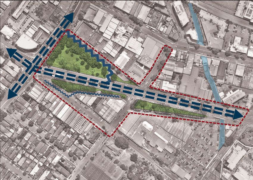
ONE - PUBLIC DOMAIN not include layout of King Street and proposed safe
separated cycleway routes. (Please refer to "Figure 1 Site
PLAN IS ONE. location and context plan").
4 West End Stage 1 Public Domain Plan Report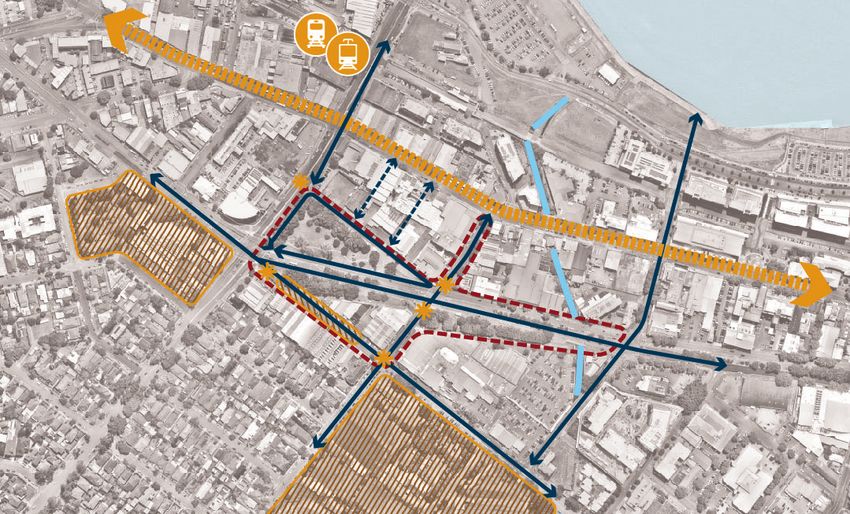
WICKHAM
PARK
HONEYSUCKLE HUNTER
PRECINCT RIVER
HU
NT
ER
ST
PA
R RY
ST
RE
ET
KING
S TRE
ET
Y)
HW
T
LS
IC
EE
IF
AC
ST
(P
E
AV
T
AR
EW
PA
ST
R RY
ET
ST
RE
RE
ET
ST
K
NATIONAL NATIONAL PARK
R
PA
PARK SPORTSGROUND
AL
NO.2
ON
TI
NA
Legend
NATIONAL PARK West End Precinct
SPORTSGROUND Boundary
NO.1 West End Stage 1 Public
Domain Site Boundary
Figure 1 Site location and context plan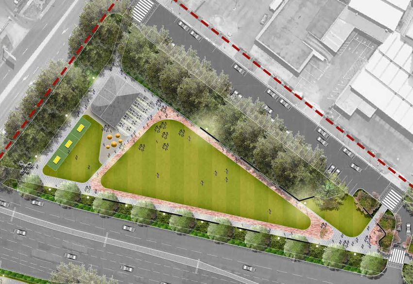
1.3 STRATEGIC WEST END PUBLIC DOMAIN
OBJECTIVES:
PUBLIC REALM / STREETSCAPE
Promote outcomes that reinforce safety and
13.
13 Consider reconfiguring slip roads on either side of
King Street (and potentially Parry Street) as share-
POSITIONING
88.
amenity in the public domain including: ways with greater landscape areas to increase the
OVERALL OUTCOMES expanse of Birdwood Park and improve pedestrian
a. Providing legibility throughout the public domain usability. Some design considerations include:
ALIGNMENT WITH NEWCASTLE URBAN 11. Interpret and reinforce important civic elements of that minimises pedestrian and vehicular conflict;
RENEWAL STRATEGY: a. maintain vehicle access to building frontages;
the city structure, including: b. Ensuring clear sight lines are maintained and
adequate lighting is included for safe use of the b. reduce the carriageway width of King (access
The West End Public Domain Stage 1 project is a. Birdwood Park as an important city park;
space day and night; road) and Parry Streets and extending the park
located in Newcastle’s West End. The West End is b. As a gateway into Newcastle City Centre; edge;
positioned to become the city's future CBD and the c. Consider CPTED principles to redirect the anti-
c. A sense of arrival in the West-End Precinct; and c. consider raising the street to the footpath level
public realm in and around Birdwood Park is located social behaviour of areas like Little Birdwood
at its heart and set to become the primary civic space d. King Street as one of two east-west green links Park; and with special paving or marked areas to delineate
in this precinct. In recognition of its importance, with a strong landscape character for the city. between vehicle and pedestrian areas;
d. Integrated lighting, way finding and signage as
Birdwood Park is identified as one of 10 special areas 22. Reinforce, improve or develop the specific and d. decrease the amount of hard surface road and
per the City Centre Public Domain Technical
within the CBD. distinctive character of this location including; providing more permeable paving, particularly in
Manual
Special areas were identified in recognition of their parking areas;
a. maintain and improve cultural and heritage 99. Identify public realm and streetscape outcomes
location, attributes, size and/or development potential. elements through design and interpretation; that contribute to the delivery of active street e. provide new landscaped areas and additional
They have the potential to realise specific outcomes with frontages and active footpaths. street trees; and
b. consider adaptive reuse of landscape or existing
respect to built form and/or public domain that could f. restrict new vehicle entries from all streets
structures where applicable; 10. Furniture, materials and tree selection to:
make major contributions to the distinct character of 10
(access to carparking and loading areas should
each activity node. c. provide for the future role of West End as the a. deliver high-quality public domain outcomes; be via rear lanes).
city's CBD; and
The Newcastle Urban Renewal Strategy provides b. consider the longevity and maintenance of
significant guidance for the outcomes being sought in d. connect with the future natural / green materials and furniture design; and
this project through: character of Cottage Creek.
c. be in accordance Newcastle City Council City
▪▪ Vision 33. Integrate Birdwood Park and Little Birdwood Park Centre Public Domain Technical Manual and the
▪▪ 9 Guiding Principles with adjoining streets and public spaces to create Street Tree Selection Manual.
▪▪ 17 Place-based, economic and transport Initiatives a significant and cohesive public domain precinct
through strong built edge, less vehicular dominance 11.
11 Embed public spaces, park and streetscapes with:
which underpin the Urban Renewal Strategy;
▪▪ 10 Special Areas with supporting guidance and
and additional street planting. a. smart technology elements;
outcomes as specified in the City Centre DCP; 44. Identify opportunities for incremental acquisition b. equitable access design principles; and
of public open space to ensure the precinct is well c. public art locations.
This guidance has been supplemented with the project served as it evolves into a commercial core precinct.
brief for this project as prepared by Council. This brief ACCESS AND MOVEMENT
includes reference to additional city-wide outcomes 55. Strengthen the spatial definition of streets
and parks through landscape and public realm 12.
12 Strengthen and improve pedestrian and cycle
such as public art, smart technology and public domain connections:
manuals. responses to enclose the park and contribute to
the creation of an outdoor room within the city. a. between the park and adjoining development.
The following objectives for the project have synthesised
these outcomes into a concise list which will be used to PARKS b. through the park and streetscapes of the
Redesign Little Birdwood Park and Birdwood Park precinct;
guide the development of the public domain plan. 66.
to create an attractive, safe and enjoyable place for c. between the park other key destinations
recreation including: including:
a. diversify the users of the space; –– the Cottage Creek corridor;
b. upgrade the amenity to activate the site; and –– the river foreshore; and
c. create an allowance for activation spaces. –– the new transport interchange at Newcastle.
77. Maintain adequate sunlight to Birdwood Park
6 West End Stage 1 Public Domain Plan Report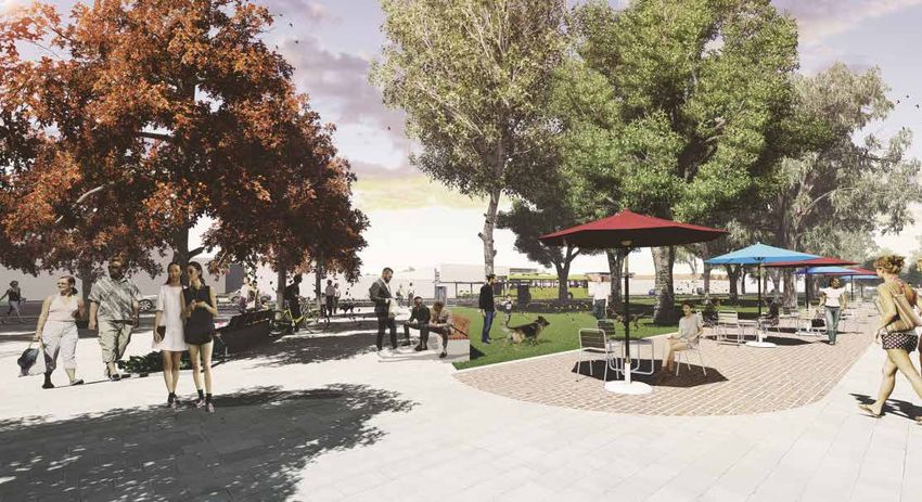
CONNECTING KEY CITY DESTINATIONS
To Stockton
Beach
Wickham
Park
Stockton
Wharf
Nobbys
Beach
WEST END
PRECINCT
Queens
Wharf
Foreshore
Park
TAFE
Campus
Birdwood
Park
Marketown Civic Park EAST END
PRECINCT Legend
Ocean
CIVIC Bath Key activity nodes
PRECINCT
Newcastle
Beach Strategic city centre
Newcastle
National Subject site
High School
Park
Hamilton City Centre Precinct
South King Edward
Public Honeysuckle precinct
Park
School
Special areas
Newcastle
Grammar Key parkland
School
Central spine
Existing links to waterfront
Future connections to
waterfront
The Bathers Way Route
Junction Newcastle Train \ Light Rail
interchange
Ferry stop
Lingard
Private Existing railway
Hospital Light rail alignment
Major road
Bar Beach
Local road
Cottage Creek
Figure 2 Birdwood Park Strategic Context
Prepared by Urbis for Newcastle City Council 7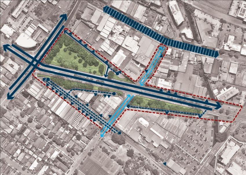
AERIAL PHOTOS

2.0 SITE                                         2.1 SITE HISTORY
                                                 HISTORICAL OVERVIEW                                             The 1970s saw a major change to the park with the

ANALYSIS &
                                                                                                                 realignment of King Street (known at the time as State
                                                 Birdwood Park was established on the 27th February              Highway 10A). Community resistance to the road was
                                                 1890 when an area of approximately 3 acres was                  vocal, with a significant spike in references to the park in
                                                 gifted by the Australian Agricultural Company to                local papers. This resistance was centred around future

CONTEXT
                                                 the Municipality of Newcastle to be used for ‘public            traffic concerns and the removal of 17 large fig trees
                                                 recreation’. The reserve soon became known as the               (which would have likely been an included to the current
                                                 West End Park. Improvements to the park were made               heritage listed trees in the park) in March 1973. A
                                                 by the Council with newspaper references announcing             defining image of the community action was an elephant
                                                 its ‘beautification’. This work continued with a 1918           (from a travelling circus) taking on the excavators (refer
                                                 reference warning vandals not to ‘destroy the trees,            images opposite). During this development, the air raid
                                                 flowers and plants in the park’.
BIRDWOOD PARK HAS                                Field Marshall William Riddell Birdwood, a veteran
                                                                                                                 shelter was also demolished (see image).
                                                                                                                 No significant changes were made to Birdwood Park              Figure 4 Aerial Photograph in 1966
A LONG HISTORY AS                                commander of the Gallipoli campaign, visited Newcastle
                                                 in April 1920. Although there is no mention of a visit to
                                                                                                                 apart from the installation of public art, developed by
                                                                                                                 local Hunter Institute of Technology students, which
                                                                                                                                                                                Source: Newcastle Local Studies Library

A KEY PUBLIC SPACE                               the park, Birdwood Park has a strong relationship with
                                                 the adjacent heritage listed 1910 Army Drill Hall, the
                                                                                                                 highlights local indigenous motifs, the parks role as a
                                                                                                                 mustering area for World War 2 soldiers and the Coal
IN NEWCASTLE'S                                   location of military recruitment during World War I and
                                                 II. It is likely that West End Park was renamed Birdwood
                                                                                                                 Strike period. Most recently a public art seat was
                                                                                                                 installed in the park directly in front of the Drill Hall in
CITY CENTRE.                                     Park in his honour shortly after his visit.
                                                 An extension of the park had been proposed on a number
                                                                                                                 1999. The art seat is titled The Sitting Stone and was
                                                                                                                 created by John Turier.
UNDERSTANDING                                    of occasions. Evidence points to this being successful
                                                 in 1945, with the addition of a triangular piece of land.
                                                                                                                 Birdwood Park continues to build on this tradition hosting

THIS HISTORY AND                                 The land, along with the proposed installation of new
                                                 children’s play equipment totalled £8,000.
                                                                                                                 the cabaret Circus Avalon in a big tent for the upcoming
                                                                                                                 Newcastle Fringe Festival.

INTERPRETING IT WITHIN                           Birdwood Park has been both a geographic and

ITS NEW ROLE AS THE                              cultural gateway to inner Newcastle. The park features
                                                 prominently in the city’s history for hosting circus’,

HEART OF THE WEST END                            carnivals, charity events, picnics and other social
                                                 activities. In 1947 it also become host to a baby clinic                                                                       Figure 5 Aerial Photograph in 1974

WILL BRING NEW LIFE TO                           during the baby boom, which was located in a former air
                                                 raid shelter located on the southern side of the park.
                                                                                                                                                                                Source: Newcastle Local Studies Library

THIS IMPORTANT SPACE.                            The location of the park also provided a meeting area
                                                 for patrons attending events at the then nearby Greater
                                                 Newcastle Stadium. The stadium, which opened in 1938
                                                 and operated for 26 years, could seat 4000 patrons
                                                 and held a variety of entertainment events and boxing
                                                 matches.
                                                 Birdwood Park was also a prominent site for industrial and
                                                 socio-political rallies and gatherings during the 1940s, in
                                                 particular during the 1949 Coal Strikes. The Coal Strikes
                                                 were significant in that it was the first time the Australian
                                                 Military had been used in peacetime to disrupt industrial
                                                 action. Newspapers documented rallies of up to 15,000
                                                 (see "Key Events" on the following page).                       Figure 3 1960 Map showing proposed new highway                 Figure 6 1910 Map of Newcastle showing West End Park
                                                                                                                 Source: UoN Cultural Collection - Hunter Photo Bank            Source: UoN Cultural Collection - Hunter Photo Bank

8   West End Stage 1 Public Domain Plan Report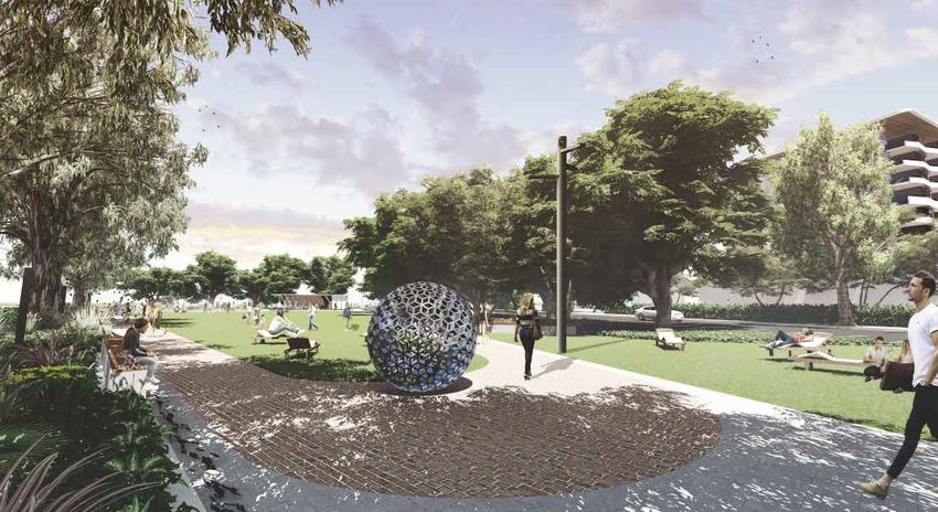
KEY EVENTS
1890     Australian Agricultural Company gifts a 3-acre reserve
         which becomes known as West End Park
1892     Newspaper references Newcastle Council ‘beautifying’
         the park
1910     Army Drill Hall is completed
1918     Newspaper references to West End Park gardens of
         trees, flowers & plants in the park.
1920     General Birdwood visits Newcastle – soon after the
         park is renamed in his honour.                                          Birdwood Park (centre right) Source: Lost Newcastle/Facebook

1931     First reference to enlarging the park by the Mayor
1930/40s Numerous references to carnivals, circus’s and charity
         social events held in Birdwood Park
1938     Greater Newcastle Stadium opens nearby                                                                                                                          ALP rally during 1949 coal strike: View looking east, with Drill Hall in background. Source: Trove

1940s    Significant socio-political rallies occur in the park
1945     Extension of the park to include triangular piece of land
         and new play equipment
1947     WW2 Air Raid Shelter commences role as a baby clinic
1949     Major coal strikes with large union and ALP meetings
         held in Birdwood Park. Community rally activities such
         as anti-war meetings prior to World War 2
1950     Birdwood Park considered for War Memorial Site,
         however was dismissed due to future DMR plans
1972-73 Major demonstrations in the park against removal of
         tress and roadway construction
1973     King Street deviation opened
1999     The Sitting Stone art seat installed                                    View South of Birdwood Park. Source: Trove                                              ALP rally during 1949 coal strike: View looking west. Source: Trove

                                                                                                                During King Street construction: Demolition of last WW2 Air Raid Shelter                                 Aerial view of Little Birdwood Park and Stadium (sawtooth roof) with
During King Street construction: Abu the elephant in 1973. Source: Newcastle Herald                             (1972). Source: UoN Cultural Collection - Hunter Photo Bank                                              tip of Birdwood Park at left. Source: Lost Newcastle/Facebook

                                                                                                                                                                                                                                      Prepared by Urbis for Newcastle City Council      9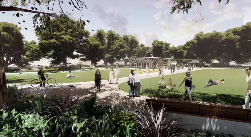
2.2 SITE CONTEXT

10   West End Stage 1 Public Domain Plan Report
LOCAL CONNECTIVITY
NEWCASTLE INTERCHANGE
HONEYSUCKLE
FUTURE LANEWAY PRECINCT
CONNECTIONS
PA
R RY
ST
RE
ET
HUN T
TAFE CAMPUS ER S T
R EE T
KING
S TRE
ET
Y)
MARKETOWN
HW
ENTRY
IC
IF
AC
PARRY STREET
(P
TO CIVIC
E
PRECIN
AV
CT
T
AR
EW
ST
T
LS
EE
ST
ET
RE
NATIONAL PARK
ST
RK
PA
AL
ON
TI
NA
Figure 7 Birdwood Park Local Connectivity
Prepared by Urbis for Newcastle City Council 112.3 PHOTOGRAPHIC AUDIT
PARRY STREET, NATIONAL PARK STREET
AND KING STREET (HIGHWAY)
Park entrance at National Park and King Street intersection is
dominated by concrete and bitumen and has no function
Open lawn area is framed by trees (however succession planting
blocks sight lines to adjoining area) and reduces usable area
Planting blocks sight lines while providing little
Poor legibility due to winding pathway along King Street edge of park visual or physical protection from adjoining traffic
No pedestrian amenity along King Street slip road is
Fig trees within open parkland block sight lines Lack of facilities within parkland contrasted by figs which provide shade and define park edge Parking adjacent to Birdwood Park
12 West End Stage 1 Public Domain Plan ReportPARRY STREET, NATIONAL PARK STREET
AND KING STREET (HIGHWAY)
Lack of pedestrian amenity to King Street access road
Historical fig tree planting marks
original boundary to park
King Street access road turn-around Parry Street and King Street
Planting and curved pathway
Parry Street dead end result in poor pedestrian legibility Recent development creating active uses to take advantage of amenity setting King Street access road dead-end has poor pedestrian connectivity and amenity
Prepared by Urbis for Newcastle City Council 13LITTLE BIRDWOOD PARK
(SOUTH OF KING STREET)
Little Birdwood park pedestrian connections and seating
areas poorly located and don't continue connections
Entrance Signage
Camphor Laurels line little Birdwood Park along King Street access road Entrance to Marketown is partly concealed and provides no activation or casual surveillance of park
King Street access road adjacent to Little Slip road entrance to Marketown carpark and King Taxi rank on King Street access road with poor pedestrian Loading area for Marketown shopping
Birdwood Park provides local access only Street access lane results in pedestrian/vehicle conflict waiting area, abandoned trolleys and no natural surveillance centre off King Street access road
14 West End Stage 1 Public Domain Plan ReportPARRY STREET, NATIONAL PARK STREET
AND KING STREET (HIGHWAY)
Parry Street looking east from King
Street/Stewart Avenue intersection
Public Art in King Street Median
Existing King Street does not create gateway character King Street and Stewart Street intersection at Birdwood Park
Parry Street footpath is cluttered with services, Overhead wires dominate streetscape Parry Street is not a through street, over scaled
driveways and no pedestrian amenity along National Park Street National Park Street has single sided tree planting and poor pedestian amenity
Prepared by Urbis for Newcastle City Council 152.4 SITE ANALYSIS MAJOR ROAD CORRIDORS
OBSERVATIONS CREATE BARRIERS TO
PEDESTRIAN MOVEMENT AND
FRAGMENT GREEN SPACE
CURRENTLY LITTLE KING
SITE CONSTRAINTS - A FRAGMENTED STREET IS USED AS A
PARK SHORT CUT
VE
HU
TA
NT
ER
AR
ST
EW
ST
Y/
HW
IC
IF
C
PA
T
KS
AR
LP
NA
LI
T IO
TT
LE
NA
KI
NG
ST
C OT
TAG
E
CR E
EK
KING
FRAGMENTED OPEN ST
SPACE WITH NO
STRUCTURE / PURPOSE
PA
R RY
ST
VEHICLE ACCESS LANES
ISOLATE GREEN SPACES
FROM ADJOINING USES SLIP ROAD ENTRANCE
Legend
REDUCING THEIR DISCONNECTS LITTLE
BIRDWOOD PARK FROM
ST
Site boundary COTTAGE CREEK
R K
PA
Softscape area AL
ON
TI
NA
Major barrier
T
LS
EE
ST
Secondary barrier
Minor barrier
Figure 8 Site Analysis - Fragmented Park
16 West End Stage 1 Public Domain Plan ReportVE
VEHICLE MOVEMENT & ACCESS
TA
R
WA
TE
/S
WY
CH
IF I
C
PA
LI
TT
LE
KI
NG
ST HUN T
ER S T
C OT
TAG
E
CR E
EK
KING
ST
Legend
Site boundary
Main road & primary
pedestrian spine
Primary vehicle road
PA
ST
Vehicle access - rat run R RY
K
ST
R
PA
Vehicle access - servicing
T
LS
AL
EE
No through road
ON
ST
TI
NA
Busy local roads
Calm local roads
Driveway access
Figure 9 Site Analysis - Vehicle movement and access
Prepared by Urbis for Newcastle City Council 17PEDESTRIAN ACCESS & CIRCULATION TO NEWCASTLE
INTERCHANGE
VE
TA
AR
EW
ST
INDIRECT PATHWAYS
Y/
DON'T FOLLOW
HW
HU
DESIRE LINES NT
IC
ER
ST
IF
C
PEDESTRIAN
PA
NO PEDESTRIAN / VEHICLE
CONNECTION CONFLICT POINT
LI
TT
LE
T
ZEBRA /
KS
KI
NG SIGNALISED
AR
ST CROSSING
LP
NA
T IO
NA
BUS STOP
C OT
TAG
KING
ST
E
CR E
EK
NO AMENITY
ALONG FOOTPATH
PA
R RY
ST
Legend
Site boundary TAXI RANK
PEDESTRIAN
/ VEHICLE
Pedestrian footpath CONFLICT POINT NARROW
POORLY DEFINED
FOOTPATH WITH
ENTRY TO
Zebra / signalised crossing NO AMENITY
MARKETOWN
Street edge without footpath
ST
R K
PA
Marketown access
T
LS
AL
EE
ON
ST
TI
No pedestrian connection
NA
Existing bus stop
TAXI
Existing taxi rank
Figure 10 Site Analysis - Pedestrian Access and Circulation
18 West End Stage 1 Public Domain Plan ReportPROPOSED DA
ADJOINING ACTIVITY
PROPOSED DA
VE
TA
PROPOSED DA
AR
EW
ST
Y/
HW
HU
NT
IC
ER
PROPOSED DA ST
IF
C
PA
LI
TT
LE
KI
NG
ST
PROPOSED DA
C OT
TAG
KING
ST
PROPOSED DA
E
CR E
EK
Legend
EXISTING MARKETOWN
SHOPPING CENTRE
Site boundary PRESENTS BLANK EDGES
AND LOADING AREA TO
Proposed development site THE EDWARDS BAR LITTLE BIRDWOOD PARK
(AND LAUNDROMAT,
On-grade parking lot SHOP & WORKSHOP)
L Loading zone
Street parking
T
PA
LS
R
Active frontages RY
EE
ST
ST
Semi-active frontages
ST
K
R
Service frontages
PA
AL
ON
Blank walls
TI
NA
Figure 11 Site Analysis - Active frontages and proposed development
Prepared by Urbis for Newcastle City Council 19EXISTING VEGETATION & ECOLOGY
VE
TA
AR
EW
ST
Y/
HW
HU
NT
IC
ER
ST
IF
C
SCATTERED TREE
PA
SUCCESSION PLANTING
PLANTING LACKS
FOR FIGS BLOCK SIGHT
DEFINITION
LINES, OVERSHADOW STREET TREES PROVIDE
GRASSLAND AND REDUCE AMENITY AND SHADE
USABLE PARK AREA LI ALONG FOOTPATH AND
TT
LE FRAME SPACES
KI
NG
ST
KING MELALEUCA TREES
ST LOCATED WITHIN ROAD
MEDIAN AND LITTLE
C OT
BIRDWOOD PARK
TAG
E
CR E
EK
NO PLANTING AROUND
INTERSECTION
Legend
Site boundary ROW OF CAMPHOR LAUREL
TREES FRAME KING STREET
Streets lack of trees ACCESS LANE
FICUS MACROPHYLLA
TREES FRAME ORIGINAL
Lack of perimeter planting PARKLAND EXTENTS
AND DEFINE EDGES
Well defined street edge PA
R RY
Street edge to be improved
ST
ST
R K
PA
Ficus Macrophylla
T
LS
AL
EE
ON
ST
TI
Camphor Laurel
NA
Melaleuca
Other tree species
Figure 12 Site Analysis - Ecology and landscape features
20 West End Stage 1 Public Domain Plan ReportEXISTING FEATURES & ACTIVITIES
VE
TA
AR
EW
ST
PICNIC TABLES
Y/
OPEN
HW
HU
PARKLAND NT
IC
ER
ST
IF
C
FEATURE
PA
SEATING
LI
TT
LE
KI
NG
ST
ENTRANCE SIGN PUBLIC ART &
INFORMATION
PLAQUE
ENTRANCE SIGN
C OT
TAG
E
CR E
EK
KING
ST
Legend
ENTRANCE SIGN
Site boundary
Open parkland
Softscape area PLAZA
INCORPORATING PUBLIC
Hardscape plaza CONCRETE SEAT
BOLLARDS COTTAGE CREEK
Cottage Creek
PICNIC TABLES CHANNEL
Picnic table
ST
K
Seating
R
PA
PA
R
AL
RY
Signage ON ST
T
TI
LS
NA
EE
ST
Place making
Public art
i Public art - information plaque
Figure 13 Site Analysis - Park activation and features
Prepared by Urbis for Newcastle City Council 213.0 DESIGN 3.1 BIG IDEAS CELEBRATE THE PAST
Retain and celebrate the local heritage through
artwork and interpretation.
DIRECTION
22 West End Stage 1 Public Domain Plan ReportLOOK TO THE FUTURE PROVIDE OPPORTUNITIES FOR:
Respond to the future role of the West End as a major Cultural, recreational, social, leisure, environmental
Civic Place for the new CBD.
Prepared by Urbis for Newcastle City Council 233.2 DESIGN STRATEGIES &
OPPORTUNITIES
COMPLETE THE PATHWAYS CALM THE EDGES ACTIVATE ADJOINING DEVELOPMENT
Connected network of pedestrian pathways along key desire lines define Reduce pedestrian and vehicle conflicts Program active uses in adjoining development with active uses that will
and activate the edges enliven the edges
A GREEN FRAME GREEN THE STREETS AN ARRIVAL BOULEVARD
Complete the green frame of Birdwood Park Implement street tree planting to provide shade and amenity for Create a City Centre Gateway through boulevard planting along King
pedestrians Street
24 West End Stage 1 Public Domain Plan Report3.3 PLACE MAKING
CREATE A SERIES OF DESTINATIONS MAXIMISE AMENITY A UNIFIED PRECINCT
Provide a series of attractions around the edges of Birdwood Park to Identify opportunities to reclaim amenity for the future heart of the CBD Unite the streets, parks and shared spaces into a single precinct through
attract a variety of users at different times of the day and week a unified suite of materials
EVENTS COTTAGE CREEK
CAFE
GATEWAY
INFORMAL
PLAY
ENTRANCE TO ECOLOGICAL
MARKETOWN
ONE BIG PARK CREATE DISTINCTIVE PLACES
Reclaim the historic boundaries of Birdwood Park A civic green, ecological parkland and linear creek are all connected by a
people street
Prepared by Urbis for Newcastle City Council 253.4 CREATE A SENSE OF INTEGRATED PUBLIC ART
OPPORTUNITY 1 - CAFE PAVILION
PLACE & BELONGING OPEN LAWN SPACE:
PROVIDE OPPORTUNITIES FOR PASSIVE,
ACTIVE PROGRAMMED & INFORMAL
COMMUNITY EXPERIENCES
FINE GRAIN PEDESTRIAN
LANEWAY CONNECTION
3
INTEGRATED PUBLIC
ART OPPORTUNITY HUN T
ER S T
TO CHILDREN'S 7
SCULPTURAL PLAY 8 5
4
VE
10
TA
AR
LI
EW
TT
LE
ST
Y/ 9 KI
NG
ST
HW
IC
1
IF
C
C OT
PA
TAG
E
CR E
KING
ST
EK
6
11
ARRIVAL BOULEVARD
2
ST
R K
PA
AL
ON
GREEN ACTIVATED
TI
NA
STREETS
T
INTEGRATED PEDESTRIAN
LS
& CYCLE PATHS WITH
EE
NATURE RESERVE:
ST
PUBLIC TRANSPORT
IMPROVE THE VALUE OF THE
PA CELEBRATE
R
NATURAL ENVIRONMENT
RY COTTAGE CREEK
ST COUNCIL TO INVESTIGATE
WSUD
Figure 14 Preliminary sketch concept plan
26 West End Stage 1 Public Domain Plan Report3.5 PLACE MAKING
PROGRAMMING
OPPORTUNITIES
1 2 3
4 5 6
7 8 9
10 11
Prepared by Urbis for Newcastle City Council 274.0 PUBLIC 4.1 WEST END STAGE 1 – PUBLIC DOMAIN STRATEGIC
DIRECTION
DOMAIN OVERALL PRECINCT STRATEGY:
▪▪ Acknowledge Birdwood Park as an important city park;
MASTER PLAN
▪▪ Reinforce King Street as a gateway into Newcastle city centre with a strong landscape character;
▪▪ Maintain and improve cultural and heritage elements;
▪▪ Provide an urban park for the future role of West End as the city’s CBD;
▪▪ Connect with the existing and future natural and green character of Cottage Creek;
& FRAMEWORK ▪▪
▪▪
Integrate Birdwood Park and Little Birdwood Park with adjoining streets and public spaces to create a significant,
cohesive design for the precinct;
Redesign the parks and streetscapes to reinforce safety, provide clear sight lines and improved lighting;
▪▪ Identify public realm outcomes that contribute to the delivery of active street frontages;
▪▪ Furniture, materials and tree selection will deliver high quality public domain outcomes in accordance with the
Newcastle City Council City Centre Public Domain Technical Manual and Street Tree Selection Manual;
THIS SECTION OF THE ▪▪ Strengthen and improve pedestrian and cycle connections between key destinations and through the park and
Where possible decrease the amount of hard surface road and provide new landscape and pedestrian friendly
REPORT DESCRIBES THE
▪▪
spaces;
VISION FOR THE WEST Integrate Smart City elements into the public domain;
▪▪
▪▪ Address anti-social behavior through CPTED principles.
END STAGE 1 PUBLIC THE BIG IDEAS:
DOMAIN AND SETS OUT 1. Celebrate the Past: retain and celebrate the local heritage through artwork and interpretation;
2. Look to the Future: respond to the future role of the West End as a major Civic Place for the new CBD.
THE KEY PRINCIPLES AND 3. Provide Opportunities for: Cultural, recreational, social, leisure, environmental
ELEMENTS OF THE PUBLIC
DOMAIN IN A SERIES OF
FRAMEWORK DIAGRAMS.
28 West End Stage 1 Public Domain Plan ReportB EL
To Newcastle
LE V
Interchange
UE
S TR
EE T
Y)
HW
IC
IF
C
PA
E(
NU
VE
LI
TT
TA
LE
AR
KI HUN T
NG ER S T
EW
ST R EE T
ST
PA RE
R ET
RY
S TR
EE
T BIRDWOOD
PARK
KING
S TRE
ET BIRDWOOD
PARK PLAZA
C OT
PA
TAG
R RY
ST
E
RE
CR E
ET
EK
ET
RE
ST
KING
K
LIT TLE B S TRE
R
PA IRDWOOD ET
PARK
AL
ON
Marketown
TI
Shopping Centre
NA
To Newcastle
Civic and East
W End
AR
RA Public Art - Council to investigate
H alternative locate to best celebrate the
ST
T
RE piece of park
EE
ET
TR
LS
EE
ST
To National Park
1:1500 @ A3
Figure 15 Illustrative Public Domain Plan
Prepared by Urbis for Newcastle City Council 294.2 ACCESS & MOVEMENT
FRAMEWORK
LEGEND
Pedestrian Park Connections
Pedestrian Internal Park Loop
Pedestrian Enhanced Streetscape
Path
Pedestrian Improved Street Crossing
Future Laneway Connection
Enhanced / New Pedestrian Plaza
Spaces
Figure 16 Access and Movement Framework
30 West End Stage 1 Public Domain Plan Report4.3 STREET TYPOLOGIES
LEGEND
Gateway - King Street
Connection - National Park Street
Event - Parry Street
Local Access - King Street Access
Streets
Shared Street - Access Driveway
Figure 17 Street Typologies Framework Plan
Prepared by Urbis for Newcastle City Council 31To Newcastle
Interchange
Y)
HW
IC
IF
C
PA
E(
4.4 KEY PUBLIC
LI
NU
TT
VE
LE
KI
TA
NG
SPACES & PLACES
AR
ST
EW
2 RE
ET
ST
FRAMEWORK
1
Birdwood Park
3
KING
S TRE
ET
4
PA
R RY 6
ST
RE
ET
13
8
7
ET
9
RE
ST
R K
PA
AL
ON
TI
NA
Marketown
Shopping Centre
12
32 West End Stage 1 Public Domain Plan Report
To National ParkB EL
LE V
UE
S TR
EE T
KING STREET - CITY CENTRE GATEWAY:
The King Street spine marks a place of arrival. The place
where you feel like you have transition from the suburban
to the urban. The historic threshold to the city centre.
Key design principles include:
1. A linear gateway that the motorist will move through;
HUN T
2. Avenue Tree planting;
ER S T
R EE T 3. Formal hedge planting to both sides of King Street;
T
4. Proposed smart pole lighting
EE
TR
5. Punctuated with large scale public art work that
KS
highlights the arrival points to Birdwood Park and
AR
LP
Little Birdwood Park.
NA
T IO
NA
5
Key Plan
LEGEND
Active play space: ping pong + sculptural play
1
elements
Park cafe, public toilet, council storage & Smart City
2
C OT
communication room
TAG
3 Open lawn
E
CR E
4 Birdwood Park plaza
EK
5 National Park Street planting upgrades
6 King Street Park
7 Parry Street landscape upgrade
Little KING
S TRE
ET 8 King Street South shared zone
Birdwood
Park
10 9 Marketown Entrance Plaza
11 10 Little Birdwood Park
Council to investigate WSUD for Little Birdwood
11
Park
12 National Park Street intersection upgrade
13 Cycle access only
Figure 18 Key Spaces and Place Framework Plan
T
EE
1:800 @ A3
TR
LS
EE
ST
Prepared by Urbis for Newcastle City Council 333D VIEWS - AERIAL 34 West End Stage 1 Public Domain Plan Report
3D VIEWS - BIRDWOOD PARK CAFE & PLAY SPACES

                                              Prepared by Urbis for Newcastle City Council   35
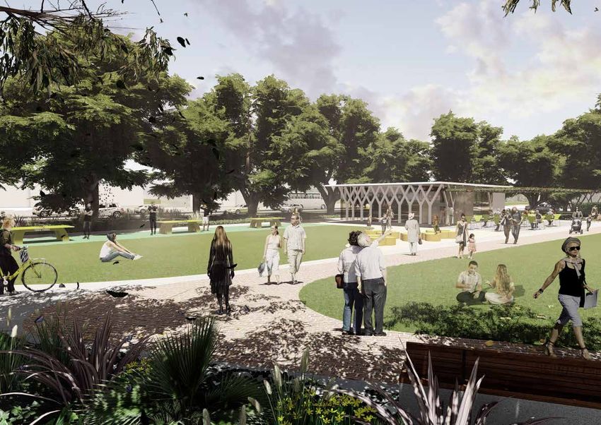
BIRDWOOD PARK: LOCAL URBAN PARK LEGEND
1 Potential location for public art
A LOCAL OPEN SPACE FOR THE
FUTURE RESIDENTS AND WORKERS 2 Table tennis pods (active space)
OF THE WEST END. ONE THAT IS 3 Sculptural play elements
DISTINCTLY URBAN IN CHARACTER. 4
Cafe + public toilets + council store room & Smart
City communication room
Birdwood Park will become the heart of the future West 5 Existing fig trees + perimeter planting added
End CBD. The public realm design aims to provide a 6 Open green space
platform for cultural and civic events. The master plan
will create energy by providing activities and destinations 7 Internal park path
to draw people in. The design responds to the existing
cultures, climate and day and night time activities and 8 Gateway tree planting
will provide physical openness and accessibility for all.
9 Shrub planting under trees
The spaces have been designed to be flexible, adaptable,
10 Low hedge against King Street
activated, safe and welcoming.
11 Bespoke seating / benches
Key design principles include:
1. To create a layered public realm framework that 12 Pedestrian lighting spaced between trees
ensures the park is punctuated by a series of small,
13 Proposed RMS - REF road configuration
medium and large scale events. The events will
encourage pedestrian movement from one end to the 14 Deciduous tree grove to park entry
other, drive activation and provide the infrastructure
for local activities and celebrations. 15 Raised pedestrian crossing
2. Design a memorable pedestrian place, defined by:
16 Existing parking
a. Formal avenue of shade trees (existing and
proposed);
b. Open flexible central parkland;
c. Bespoke Park Café (with toilets and Council
Storage & Smart City communication room) and
terrace;
d. Central promenade with feature pedestrian scale
lighting;
e. Feature paving that draws people through the
space;
f. High quality furniture;
g. Integrated public art
h. Smart City elements.
3. Celebrate the heritage value of the space as a place
for community gathering is retained through the
creation of central open space which is flexible and
usable for events and meeting spaces. Heritage trees
are incorporated with new planting.
4. Provide an activated and safe environment
5. Respond to the park role as a major civic place
Key Plan
36 West End Stage 1 Public Domain Plan Report15
Y)
HW
IC
IF
C
PA
E(
NU
VE
TA
AR
LI
EW
TT
LE
ST
KI
NG
ST
RE
ET
5
16
4
5
2
3
7
Birdwood Park
1 6
12
15
12
11
8 9
12
1
10 14
KING
S TRE
ET
13
1:400 @ A3
Figure 20 Birdwood Park Concept Plan
Prepared by Urbis for Newcastle City Council 37BIRDWOOD PARK: ARRIVAL PLAZA
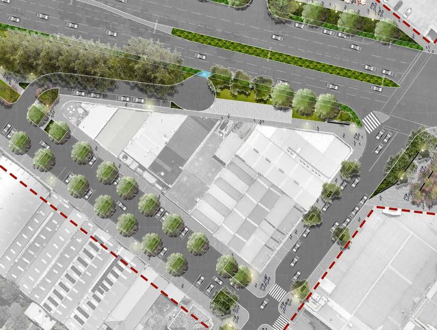
Birdwood Park Arrival Plaza is a transitional space from
the surrounding streetscapes (corner of King Street
and National Park Street) to Birdwood Park The public
domain plan will create a small-scale pedestrian plaza
that incorporates public art, lighting and seating benches
along the primary path into Birdwood Park.
The space is divided up into two zones that can
accommodate different programs and actives.
LI
TT
7 LE
KI
NG
ST
RE
ET
LEGEND
2
1 Raised pedestrian crossing
2 Proposed deciduous tree grove
3 Birdwood Park entrance plaza
4 Potential location for public art 5
5 Existing street trees
6 Existing Melaleuca trees
7 Existing parking 2
8
8 Proposed street trees
9 Existing street trees 1
3
4
5
KING
S TRE
ET
6
KING
S TRE
ET
Key Plan
Figure 21 Birdwood Park Arrival Plaza Concept Plan
38 West End Stage 1 Public Domain Plan ReportHUN T
ER S T
R EE T
NATIONAL PARK STREET
REVITALISATION:
The proposed streetscape upgrades along National Park
Street will provide an enhanced pedestrian amenity
along this key connection back to Hunter Street.
Key design principles include:
1. New street tree planting and rain gardens;
2. Pedestrian blisters at the intersection with Parry
Street;
3. Smart poles;
4. Upgraded pavements
5. Formalized planting at the interfaces with Birdwood
and Little Birdwood Parks.
8
9
ET
RE
ST
KR
PA
AL
ON
TI
NA
Key Plan
1:200 @ A3
Prepared by Urbis for Newcastle City Council 393D VIEWS - BIRDWOOD PARK EASTERN ARRIVAL 40 West End Stage 1 Public Domain Plan Report
3D VIEWS - BIRDWOOD PARK ENTRANCE PLAZA

                                          Prepared by Urbis for Newcastle City Council   41
LITTLE BIRDWOOD PARK:
EMBRACE AND ENHANCE THE
EXISTING NATIVE VEGETATION AND
PROXIMITY TO COTTAGE CREEK 4
INCORPORATE OPPORTUNITIES FOR 4
4
LOCAL STORMWATER TREATMENT AND KING
1
ADDITIONAL NATIVE VEGETATION. S TRE
ET
5
Little Birdwood Park will become unified with Birdwood
park through consistent paving, furniture, lighting and 4
planting. The master plan proposes to remove the 4
ET
14
roadway between Officeworks and National Park Street,
RE
ST
replacing it with an arrival plaza to Marketown providing
KR
an opportunity to activate the frontage to King Street.
PA
13
AL
2
ON
Key design principles include:
TI
4
NA
1. Improve the value of the natural environment with 4 6
sustainable planting;
2. Incorporate sculptural landform, environmental
artworks;
3
3. Formalise the arrival plaza to Marketown
a. Provide clear sightlines to the entrance of the
shopping centre
b. Incorporate accent trees, seating benches and
pedestrian scale lighting to the plaza
c. Upgrade the connection to the bus stop on King 7
Street
4. Improve pedestrian connection to Cottage Creek and
east of the creek;
5. Inclusion of Smart City elements. LEGEND
Existing trees and proposed garden bed to national LITTLE BIRDWOOD PARK ANTI-SOCIAL BEHAVIOR CONTROL STRATEGIES:
1 8 Existing road to become loading only
park street • Upgrade whole of Little Birdwood Park;
Ornamental tree grove with bespoke seating + 9 • New arrival plaza to the Park and Marketown, will include open ‘civic’ design
2 Marketown parking entry
lighting with clear sight lines and upgraded pedestrian scale lighting;
3 Cafe dining zone 10 Council to investigate inclusion of WSUD • Remove all existing furniture in the park;
• Insert a formal lawn adjacent to the arrival plaza and future outdoor café
4 Future tree planting 11 Existing Meleleuca's terraces;
• Long term plan to activate the edge of the park by opening up the Marketown
5 Existing bus stop 12 Existing trees frontage;
• Improve lighting throughout the whole park;
6 Little Birdwood Park 13 Open lawn
• Integrate cycle path to provide passive surveillance of the park.
7 Existing loading dock entry 14 Existing parking
Key Plan Figure 22 Little Birdwood Park Concept Plan
42 West End Stage 1 Public Domain Plan Report12
C OT
TAG
E
CR E
EK
11
KING
S TRE
ET
14
10
8
14
9
COTTAGE CREEK
T
EE
TR
LS
EE
ST
1:400 @ A3
Prepared by Urbis for Newcastle City Council 43KING
S TRE
ET
1
PARRY STREET: CREATIVE HUB PA 2
R RY
ST
RE
PARRY STREET IS ALREADY A HUB OF LEGEND
ET
CREATIVE ENERGY AND BUSINESSES. 3
1 Low hedge to King Street verge
STREETSCAPE IMPROVEMENTS AND
IDENTIFICATION OF UNDERUTILISED 2 Shared pedestrian/cycle path
AREAS WHICH COULD BECOME 3 Proposed deciduous tree
NEW PUBLIC SPACES PRESENT THE 4 Existing figs
5
OPPORTUNITY TO FOSTER THIS CREATIVE
5 Car parking
ENERGY INTO THE PUBLIC REALM.
6 Proposed realigned intersection
Key design principles include: 7 Street tree planting
1. New street tree planting and community gardens; 8 Shared zone
2. Smart Poles;
3. Upgraded pavements 9 Existing trees
4. Reduced road surfaces that have been reclaimed as
10 Proposed trees
additional green parklands
11 Seating bench
The restructured street cross section provides a
wonderful opportunity to close the street down to 12 Proposed street trees
vehicular traffic for weekend markets and street
festivals and celebrations. 13 Proposed pedestrian crossing
14 RMS proposed road alignment
15 Proposed taxi bays
16 Existing bus stop
16 Cycle access only
Key Plan
Figure 23 Parry Street Concept Plan
1:400 @ A3
44 West End Stage 1 Public Domain Plan ReportKING
S TRE
ET
14
4
17
9
10
8
9
11
7
PA
R RY
ST
RE
ET
ET
RE
ST
KR
PA
AL
15
ON
TI
NA
7
16
12
13
9 6 Prepared by Urbis for Newcastle City Council 453D VIEWS - PARRY STREET MARKET DAY 46 West End Stage 1 Public Domain Plan Report
3D VIEWS - MARKETOWN FORECOURT & ALFRESCO DINING

                                                   Prepared by Urbis for Newcastle City Council   47
5.0 DESIGN 3
1 4
ELEMENTS 5
7
6
2 4
5
3
6
5
3
8
3
6
3
48 West End Stage 1 Public Domain Plan Report5.1 LIGHTING
NOCTURNAL PLAN
LEGEND
1 Cafe/restaurant lighting
2 Temporary cinema/outdoor cinema
3 Pedestrian lighting (4m)
4 Multi directional pole top lights (8m)
5 Up-lighting to public art
6 Strip lights to edge of bench seats
7 Stud lighting on edge of path
8 Cycle access only
5
3
6
3
1:800 @ A3
Figure 24 Nocturnal Plan
Prepared by Urbis for Newcastle City Council 49LIGHTING CONTINUED...
The issues of safety and amenity cannot be separated.
People’s perceptions of safety are influenced by factors
such as visual comfort, way-finding, and the ease with
which objects and places can be recognised.
Good lighting should enhance the transformation from
day to night. In doing this, it should produce positive
changes that enrich people’s experiences and enhance
their comfort within of the city.
The vision for the West End Stage 1 lighting design is
to include a variety of layers for lighting that covers all
users of the space with a distinctive lighting design and a
seamless extension of the adjacent street lighting. This
will be achieved by several designed elements including:
▪▪ Smart Pole and traditional street lighting
▪▪ Up lighting of heritage trees
▪▪ Low level pedestrian scale pole top lighting
▪▪ Integrated lighting into the public domain elements
(seating benches, bollards, café, art work) and
▪▪ Event lighting (multi directional pole top light fittings).
Newcastle . United Kingdom
Titisee-Neustadt . Germany
50 West End Stage 1 Public Domain Plan Report5.2 GREEN SPACE
The City of Newcastle acknowledges that trees are
an important urban asset that provide environmental,
aesthetic, cultural, wayfinding and economic benefits
for the city centre. Trees also offer a contrast with the
building facades that dominate most city streets, soften
traffic noise, screen unwanted views, reduce glare and
provide shade during the warmer months of the year.
The objectives for West End Stage 1 Public Domain
will be to retain the existing establish Ficus Sp. Trees.
These street trees are the predominant element that
defines the green character and reinforces the historical
Birdwood Park boundaries as well as the gateway to the
Newcastle’s city centre. The existing Camphor Laurel
and Melaleuca sp. Will be retained and expanded upon
within Little Birdwood Park.
Water Sensitive Urban Design planter beds will be
integrated into Little Birdwood Park and along National
Park Street. These planter beds will improve the
streetscape and treat as much storm water collection as
possible before it enters the adjacent Cottage Creek.
All proposed trees species will be selected in accordance
with the NCC Newcastle Street Tree Selection Manual.
To ensure the ‘right tree is planted in the right place’.
Prepared by Urbis for Newcastle City Council 515.3 FURNITURE The City of Newcastle Public Domain Technical Manual (2014) identifies the need for a coordinated suite of furniture for the city centre public domain. Distinctive areas have been identified in the manual to allow for bespoke seating to be installed to express the special nature key spaces within the city centre. West End Stage 1 will have a site specific seating benches, raised seating platforms, outdoor tables, play equipment and multifunctional sculptural play elements that will provide for individuals and groups of peoples. 52 West End Stage 1 Public Domain Plan Report
5.4 SMART CITY ELEMENTS SMART BINS
Sensors linked to the IoT
NEWCASTLE SMART CITY
SMART SCREENS
platform collect data on SMART ENERGY
The City of Newcastle is an emerging smart city and we Interactive smart
screens around the CBD
the city and transform Buildings are powered by
are looking at ways to introduce new digital initiatives Our future city could look like this provide information to
everyday items into smart
infrastructure. Bin sensors
the sun through solar
panels connected to
help people find out the
to our city centre. West End Stage 1 Public Domain Plan latest on what's going
will detect when bins are
full and optimise
battery storage.
will include digital initiatives, such as public wi-fi, smart SMART MOBILITY
All forms of transport are
on in the city. collection routes. ELECTRIC VEHICLE
information panel, smart bin, smart lighting, mobile linked together to make
CHARGE POINTS
Electric vehicle charge
getting around simple
parking app, and smart crime prevention technology. SMART CITY APP and seamless. Timetables points are available
are synced and vehicle around the city to
A city app makes SMART PARKING AND
Integration of technology into Birdwood Park and Little locations provided in real recharge electric cars
information on the city TRAFFIC SENSORS
time to provide a better and other e-vehicles,
Birdwood Park will provide a demonstration project easily available. What's on
in Newcastle, how to get
travel experience. all powered by the
smart grid.
Sensors in the street detect
available parking and send
enabling residents and visitors to interact with and to music venues and
restaurants, or real time
data to drivers. Intelligent
traffic systems provide
experience the benefits of smart city technologies. transport info is simple information to help driver's
and up-to-date. better handle congestion
Smart city initiatives form a key role in enabling urban or accidents.
liveability, cultural activation and economic development INTERNET OF THINGS (IOT)
for the city centre. An IoT platform connects
almost any device in the
INNOVATION HUB AND
DIGITAL SANDBOX
city to the internet and to City data collected through
each other. Apps, sensors, the IoT Platform is provided to
and smart city the Innovation Hub for
5.5 INTEPRETATION
applications generate entrepreneurs, start-ups,
data on the city. researchers and students to
experiment and collaborate on
ideas for improving the city.
The integration of smart city technology into Birdwood
Park and Little Birdwood Park will provide a platform to
tell stories about the local history of the site.
Smart phone apps will be able to communicate both the
history of the site along with future public events and
celebrations.
UNDERGROUND FIBRE
OPTIC CABLING
FUTURE EDUCATION
Fibre optic cables run
The smart city has a underground throughout the city
University at its heart. bringing high-speed data and
NewSpace uses new ways information to business,
of teaching and researching students, visitors and residents.
to drive forward our The fibre-enabled city is
PUBLIC WIFI thinking about the attractive and more liveable.
LA
MA
NS challenges of the future.
T Free public WiFi is
TECHNOLOGY IN THE STREET available providing high
SMART PARKING APP
Light rail stops with speed quality internet
KIN
GS sensor-based smart lighting access no matter where A smart parking app will
T
and technologies including you are in the CBD. guide drivers quickly to the
INTERACTIVE PLAY FEATURES interactive information best available parking spot
HU
NTE Sensor-based interactive screens, device charging, near their destination; pay by
RS
T
lighting and water features WiFi hotspot and help SMART LIGHTING phone and top up remotely.
WO
RK
create a dynamic public points to make life easier Smart poles provide energy
SH
HU
NT
OP
WA domain and provide and safer. efficient LED lighting, but
Y
ER
entertainment and bring that's not all. Each pole can
This is an indicative illustration only.
RI
VE
R innovation to the city streets. house WiFi signal points,
Source: Draft Smart City Strategy 2017 - sensors, public address
system and more.
2021, Newcastle City Council Newcastle City Council 24 Smart City Strategy 2017-2021 25
Prepared by Urbis for Newcastle City Council 535.6 PUBLIC ART The City of Newcastle recognises the cultural and economic benefits that flow from integrating public art into the urban fabric. The overall public art role within our city centre will range from high quality bold works on a large scale to small intricate or delicate works that add texture and intimacy to the urban experience. Public art will create opportunities to integrate a cultural layer into the city centre and enhance and strengthen wayfinding cues for people to navigate through our city with ease. Birdwood Park and Little Birdwood Park has been identified in the Newcastle Urban Renewal Strategy (2014) and the City Centre Public Domain Plan Technical Manual (2014) as a distinctive place that will incorporate seamless public art into the design of the public domain. 54 West End Stage 1 Public Domain Plan Report
5.7 EVENT OVERLAYS
Events and festivals add to the vibrant atmosphere, cultural layer, activation   BIRDWOOD PARK EVENT OVERLAY
and in the promotion of the city centre. Events and festivals also bring big     Birdwood Park has featured prominently in the city’s history for hosting circus’s, carnivals, charity events, picnics and other social
economic benefits to businesses in the retail, hospitality and tourism sectors   activities (including industrial and socio-political rallies and gatherings during the 1940s, in particular during the 1949 Coal Strikes).
for our city centre. Events also provides engagement of the wider community      The design proposals will facilitate opportunities for passive, active, programmed and un-programmed cultural events.
to create a safe, accessible and people friendly environment for all.

                                                                                                                                           POTENTIAL
                                                                                                                                           SCREEN/OUTDOOR
                                                                                                                                           CINEMA EVENT

Figure 25 Birdwood Park - Event Overlay Concept Plan

                                                                                                                                                                                                           Prepared by Urbis for Newcastle City Council   55
PARRY STREET EVENT OVERLAY
The restructured street cross section of Parry Street provides a wonderful opportunity to close the
street down to vehicular traffic for weekend markets and street festivals and celebrations.
POTENTIAL WEEKEND
FARMERS MARKETS/
CLOTHES MARKETS AS
PART OF THE CREATIVE
PRECINCT.
Figure 26 Parry Street - Event Overlay Concept Plan
56 West End Stage 1 Public Domain Plan ReportBRISBANE GOLD COAST BRISBANE MELBOURNE GOLD PERTHCOAST MELBOURNE SYDNEY PERTH CISTRI — SINGAPORE SYDNEY cistri.com CISTRI — SINGAPORE cistri.com
You can also read


