West Side Drainage Improvements Project - Township of Berkeley Heights Union County, New Jersey August 18, 2020 - DRAFT - Berkeley Heights ...
←
→
Page content transcription
If your browser does not render page correctly, please read the page content below
West Side Drainage
Improvements Project

Township of Berkeley Heights
Union County, New Jersey

August 18, 2020 - DRAFT

                               Neglia Engineering Associates (DRAFT August 18, 2020)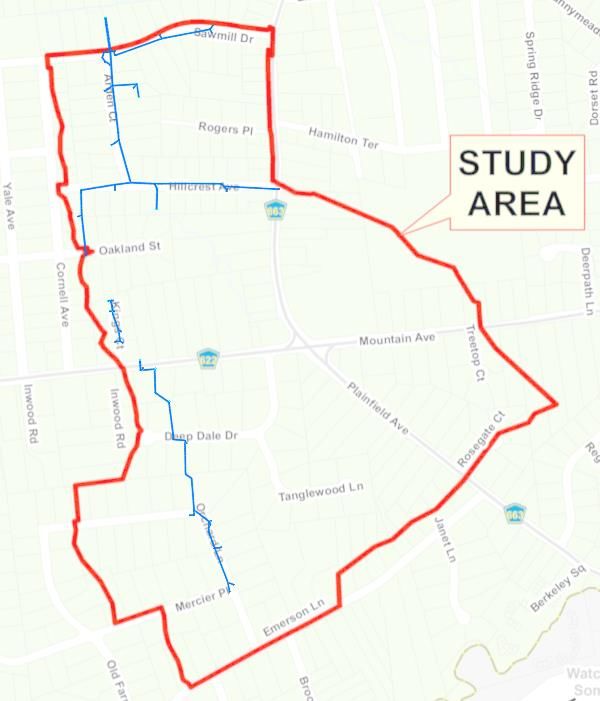
Introduction

  • The Township of Berkeley Heights has identified various drainage complaints
    stemming from an area on the west side of town, collectively called “The West
    Side” for the purposes of this study.
  • The Township has retained Neglia Engineering Associates (“NEA”) to investigate
    the causes of the drainage problems, and provide recommendations to alleviate
    them.
  • The purpose of this draft presentation is to provide a brief update of the findings
    and conceptual recommendations to address the drainage issues. A final report
    will be issued which will provide a complete, detailed analysis and
    recommendations.
  • This stage of the project is not for the purposes of construction, but rather to
    provide the Township with an understanding of the existing conditions, proposed
    remedies, and ballpark costs for the proposed improvements.

                            Neglia Engineering Associates (DRAFT August 18, 2020)
Introduction – Columbia Park (Phase II)

  • The Township has also expanded the scope of the drainage study to
    include the existing school and recreational complex area located at
    Columbia Park to investigate drainage concerns and provide
    recommendations to address any drainage issues
     • North of Hamilton Avenue, and west of Plainfield Avenue
     • Consists mainly of above-ground streams/channels
     • Additional ground topographic and aerial LiDAR surveying required to capture this
       new area
     • This Phase II portion of the analysis and report will be completed later in 2020,
       independent of the issuance of the final report for the West Side Drainage Project.

                            Neglia Engineering Associates (DRAFT August 18, 2020)
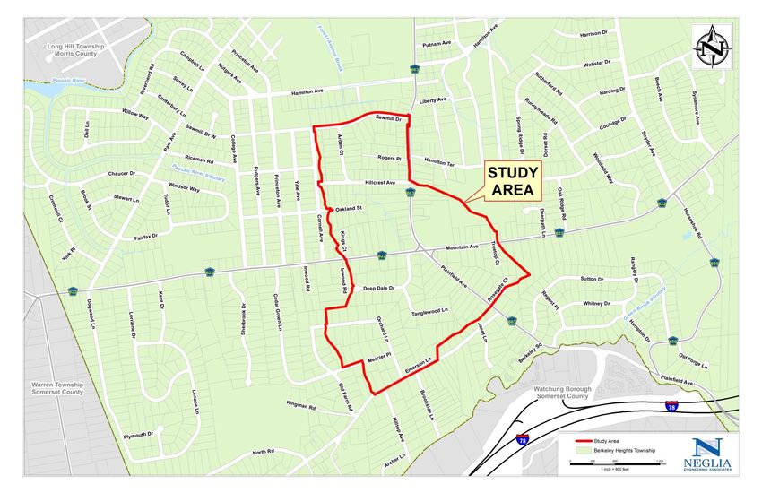
Study Area – Affected Areas

 • The study area encompasses an area beyond the limit of those residents who
   have complained, as the entire study area is interconnected via a
   combination of above- and below-ground infrastructure:
    • Above-ground: Streams, ditches, and swales
    • Below-ground: Inlets, manholes, headwalls, pipes, and culverts
 • The study area generally consists of                                        Study Area Neighborhoods

 • The total study area encompasses                           Emerson Lane            Mercer Place       Orchard Lane
                                                           Tanglewood Drive         Deep Dale Drive     Mountain Avenue
   approximately 140 acres.
                                                                Kings Court         Plainfield Avenue     Arden Court
                                                             Cornell Avenue          Saw Mill Drive       Rogers Place
                                                             Oakland Street
                            Neglia Engineering Associates (DRAFT August 18, 2020)
Neglia Engineering Associates (DRAFT August 18, 2020)
Existing Conditions
 • The study area consists of relatively steep topography, sloping from south to north,
   approximately from Emerson Lane to the south, to Saw Mill Drive to the north. There is an
   approximately 180-foot elevation change across the study area from south to north.
 • The downstream discharge point for this drainage system is the Forest Avenue Brook (south
   of Saw Mill Drive), which ultimately discharges into the Passaic River.
 • Existing Township GIS drainage mapping was incomplete and required a full detailed
   inventory of the existing drainage conveyance systems to accurately model existing
   conditions
 • NEA performed extensive topographic surveying supplemented with LiDAR aerial
   photogrammetry to be used as base mapping for the 140-acre study area. Additionally, NEA
   developed an inventory of existing drainage facilities within the study area (i.e. confirmed
   pipe sizes, materials, inverts/slopes, alignments, configurations, etc.).
 • Using the existing topography and existing drainage inventory, NEA prepared a baseline
   model to analyze how the system performs under existing conditions.
                              Neglia Engineering Associates (DRAFT August 18, 2020)
Existing Conditions
• The existing below-ground drainage system was constructed both within the Township’s
right-of-way and through multiple private properties.
• When traversing through the private properties, the stormwater conveyance system was
constructed between dwellings and roadways, and therefore makes a lot of abrupt changes
in horizontal and vertical alignments to avoid obstructions.
• There are many instances where pipes actually decrease in size when going downstream, as
opposed to increasing.
• There are multiple locations where the pipes themselves are significantly undersized, when
referencing modern engineering and hydraulics standards.
• Typically designed for a 25-year storm; existing system cannot accommodate a 1-year storm
• Improper overland drainage leads to erosion and soil transport into downstream waterways,
causing turbidity and sedimentation. This can also lead to destabilized slopes which can
further exacerbate erosion.
• If water does not enter the drainage system effectively, it will take the path of least
resistance down the slope, regardless of what’s in its path.
Neglia Engineering Associates (DRAFT August 18, 2020)Hydraulic Issues – Abrupt Alignment Changes
• Water flow within a pipe network can be easily compared to cars
travelling along a highway – consider Route 78…
• If the Department of Transportation were to construct a 90-degree bend
in the middle of the free-flowing highway, there would be a significant
traffic delay, as people apply the breaks to make the hard turn - this can
be compared to water being forced to slow down in a pipe network.
• However, unlike brakes slowing down a car, the rain cannot be stopped.
As such, when the water is forced to slow down when making an abrupt
deflection in the alignment, it will take the path of least resistance, which
is often vertically.
• This means that the water level is forced to rise, which can lead to
stormwater surcharging above the rim of an inlet or manhole, and lead to
flooding.
Neglia Engineering Associates (DRAFT August 18, 2020)Hydraulic Issues – Decreasing Pipe Sizes
• Water flow within a pipe network can be easily compared to cars travelling
along a highway – consider Route 78…
• If the Department of Transportation were to abruptly reduce the number of travel lanes
from four to three, once again, the traffic would be forced to slow down and merge,
which would cause a traffic delay.
• Similarly, when pipe sizes decrease when flowing downstream, water will backup, and
force the water level to rise, contributing to flooding.
• In addition, more water is introduced into the system, often at
these problem areas, which only compounds the problem
Neglia Engineering Associates (DRAFT August 18, 2020)Hydraulic Issues – Undersized Pipes
• Water flow within a pipe network can be easily compared to cars travelling along a
highway – consider Route 78…
• If the Department of Transportation only constructed a two-lane highway, based on current
traffic conditions, traffic flow would be severely impeded, leading to backups.
• Similarly, an undersized drainage pipe will only permit a certain amount of flow through it,
despite however much rain continues to fall. This wall cause water levels within the system to
rise, surcharging water, forcing water to find alternate paths down the slope towards the Forest
Avenue Brook.
• It should be noted that the engineering design standards likely in effect when the systems were
constructed were not necessarily comparable to those of current practice. Additionally, the
watershed itself may have been significantly more pervious, consisting of woods and open space
rather than paved roads and driveways, houses, patios, pools, etc., all of which contribute to
additional stormwater runoff entering the drainage systems.
• Current and future developments are held to much higher engineering standards related to
stormwater than those even prior to 2004. Major development projects (i.e. those disturbing
more than 1 acre or adding ¼ acre or more of net new impervious surface) are often required to
provide detention in order to reduce post-construction peak runoff rates below pre-construction
runoff rates (N.J.A.C. 7:8, updates coming in March 2021)
Neglia Engineering Associates (DRAFT August 18, 2020)Hydraulic Issues – Steep Topography and Pipes
• Water flow within a pipe network can be easily compared to cars travelling
along a highway – consider Route 78…
• If the Department of Transportation constructed Route 78 on a severely steep slope for
a stretch of the highway, and then abruptly encountered a flat stretch of the roadway,
vehicles would be traveling at a high rate of speed, being assisted by gravity. If there is
an abrupt turn, or decrease in the number of lanes, or an undersized highway, all of the
previous conditions would be significantly exacerbated by the grade.
• Similarly, if a storm pipe was constructed at a steep slope, and then encounters an
abrupt turn, reduced pipe diameter, or was undersized, all of the previous hydraulic
issues would be significantly exacerbated as a result, leading to increased flooding.
• Additionally, water being forced to make an abrupt turn, on a steeply sloped and
undersized pipe, the energy of the water flowing downhill would be transferred
vertically, which can lead to manhole rims and catch basin grates being thrust upwards.
Neglia Engineering Associates (DRAFT August 18, 2020)UNDERSIZED &
BACKPITCHED 66” PIPE
AT DOWNSTREAM END
OF CONVEYANCE
SYSTEMS
LARGE OFFSITE
STEEP TOPOGRAPHY CONTRIBUTORY
& PIPE SLOPES DRAINAGE AREA
ABRUPT CHANGE &
DECREASED PIPE SIZES
Neglia Engineering Associates (DRAFT August 18, 2020)Hydraulic Issues – Back-pitched Pipes
• There are multiple pipes which are sloped up, as opposed to sloping down, in
the direction of flow.
• This causes a hydraulic loss as water is forced to flow uphill, which causes
flow to back-up, and rise.
• Additionally, if the downstream end of the pipe is higher than the upstream
end of the pipe, there will always be stagnant water in the pipe after the rain
has stopped
• This can lead to mosquito-breeding conditions.
• This can decrease pipe velocity and therefore the efficacy of the self-cleansing process
(which in itself can lead to a buildup of debris and possibly create a partial blockage, or
a loss of capacity – same effect as an undersized pipe).
Neglia Engineering Associates (DRAFT August 18, 2020)How to fix these issues?
• The solution to virtually all of these drainage issues consists of reconstructing
most of the components of the stormwater conveyance systems.
• Abrupt bends need to eliminated, where possible. Where not possible to eliminate, additional
hydraulic considerations must be accounted for in the design to ensure proper hydraulics.
• Pipes need to sized properly to accommodate actual stormwater runoff generated by the
watershed, under current, fully-developed conditions (and including some assumption for future
development)
• Pipes should always be, at a minimum, the same diameter downstream (if not larger) to account
for compounding flow of water as more catch basins and headwalls introduce more stormwater
runoff into the system.
• Steeply sloped pipes need to be flattened and reconstructed with vertical drops in manholes and
catch basins, as the drop results in splashing within these structures, which significantly reduces
the energy, and therefore velocity, of the water within the pipes.
• All back-pitched pipes need to be reconstructed as fore-pitched pipes.
Neglia Engineering Associates (DRAFT August 18, 2020)SHALLOW PIPES
PIPES BURIED DEEPER TO
DECREASING (NO ROOM FOR
PROVIDE ROOM FOR
PIPE DIAMETER SURCHARGE)
SURCHARGE IN INLETS
STEEP PIPES UPSIZED TO
TOPOGRAPHY + ACCOMMODATE
STEEP PIPES = UPSTREAM FLOW &
HIGH VELOCITY HYDRAULIC CONDITIONS
DROPS CONSTRUCTED TO
DISSIPATE ENERGY AND
FLAT PIPE (ABRUPT REDUCE VELOCITY
VERTICAL TRANSITION)
Existing Conditions Proposed Conditions
(Before) (After)
Neglia Engineering Associates (DRAFT August 18, 2020)FORE-PITCHED &
UPSIZED PIPE (NOW A
5’x8’ BOX CULVERT –
WAS A 5.5’ ROUND PIPE)
BACK-PITCHED PIPE SAW MILL SAW MILL
(66” PIPE AT END OF DRIVE DRIVE
DRAINAGE SYSTEM)
PERMANENT
POOL OF
WATER
Existing Conditions Proposed Conditions
(Before) (After)
Neglia Engineering Associates (DRAFT August 18, 2020)Proposed Improvements
• The purpose of this portion of the project was to develop conceptual-level improvements to
address the drainage issues.
• Using the baseline model prepared for the existing conditions, NEA identified problem areas
based on hydraulic modeling and proposed remedies for these areas in order to alleviate
drainage issues.
• NEA then designed proposed drainage improvements and prepared iterations of hydraulic
models to analyze the effect of the proposed improvements on the drainage systems.
Subsequently, when reviewing the various iterations, some were not viable when considering
existing topographic and infrastructure conditions, and the process was repeated.
• Conceptual-level improvements are not necessarily ready for construction at this time. The
surveying and mapping used for the project thus far were only performed for concept planning.
• In order to develop final, construction-level plans, the next phase of the project must be
undertaken. This would include a significant expansion of the topographic surveying, as well as a
full inventory of the existing utilities within the roadway.
Neglia Engineering Associates (DRAFT August 18, 2020)Design Storm Events
• Storm design frequency relates to a probability of a given design storm being met or exceeded in a given
time period:
• A 100-year storm has a 1/100 (1%) chance of occurring once per year.
• A 50-year storm has a 2% chance of occurring once per year
• It’s possible to have (3) 100-year storms in 1 year or no 1-year storms for 5 years; these are probabilities, not predictions…
• For example, on August 4, 2020, 2.29 inches of rain fell in Berkeley Heights (duration unknown):
• If the storm’s duration was:
• 0.5 hours → 200-year storm
• 1.0 hours → 5-year storm
• 3.0 hours →Proposed Improvements
• At this point in time, the preliminary estimated cost for these improvements is
approximately $15,000,000 - $20,000,000. The costs for this project generally consist of
hard costs and soft costs:
• Hard Costs: actual construction of new drainage systems, improvements to streams and channels,
significant utility relocation, restoration of private property, restoration of public property (i.e. paving,
etc.), etc.
• Soft Costs: surveying and engineering (i.e. preparation of final construction documents), regulatory
permitting and associated fees, temporary and permanent easement acquisition, owner consent, legal
services, funding acquisition, etc.
• NEA is working with the Township to potentially seek a loan from the New Jersey
Infrastructure Bank’s, Water Bank Financing Program, through the N.J. Environmental
Infrastructure Trust (“NJEIT”).
• Low- to no-interest loan, with up to a 30-year payment term to facilitate governmental agencies to
accomplish infrastructure projects which improve water quality.
• Once final costs are estimated, the Township may phase portions of the project to align with
the project funding, whether it’s through the NJEIT program or its own financing.
Neglia Engineering Associates (DRAFT August 18, 2020)Thank you for your time.
Questions?
Comments?
Neglia Engineering Associates (DRAFT August 18, 2020)You can also read