Western Bay of Islands Maritime Access Options Report - EPA NZ
←
→
Page content transcription
If your browser does not render page correctly, please read the page content below
APPENDIX 13

27 May 2021

 Western Bay of Islands Maritime Access Options Report

1      Introduction

This report identifies sites investigated for possible development for the public to access the
water in the western parts of the Bay of Islands.

2      Background

The Far North has experienced rapid growth in the last 30 years and until the recent Windsor
landing/Rangitoto development of the south side of the Kerikeri inlet there had been no new
public boat ramps built in the Far North District for over 30 years.
The Kerikeri area has seen the fastest growth of any part of the Far North District and with
this has come a concurrent increase in the amount of people wanting to access the water.
Land around the coastline is becoming increasingly inaccessible due to development and
the cost to acquire land for development of maritime facilities is becoming prohibitively
costly.
In recent years the demand at existing facilities has seen problems with parking vehicles and
trailers and has created pressure on on-shore infrastructure. Around 15 years ago the Far
North District Council recognised these issues and started to look to develop access on the
southern side of the Kerikeri Inlet and Windsor Landing/Rangitoto. This project is only now
being realised highlighting the difficulty in developing coastal sites. While this development
will help in accessing the Bay it will in no way meet the needs of the wider community. In the
2018-2028 Long Term Plan the Far North District Council allocated $1.1M to investigate
solutions to maritime access issues.
Investigations of possible new sites for maritime access have been undertaken in recent
years but a lack of sufficient funding for development has meant that these had been
confined to ‘desk-top’ studies and limited discussion with local stakeholders. With the
introduction of the Government Provincial Growth Fund following the 2017 elections a
possible source of funding was identified leading to more robust identification of
development options.
The following sections outline investigations into possible sites for improved maritime
access.

                                                                                                  1
27 May 2021

3         Site Investigations

                                                              Opete Creek

                    Skudders Beach            Rangitane Reserve (DOC)

                                                                     ‘Reedy’s’

                                                         Doves Bay and Opito Bay
       Kerikeri
                               Waipapa Landing                Kurapari Road

Figure 1 –Investigation Sites in the Western Bay of Islands

3.1       Opito Bay

This site is preferred by the majority of recreational boaties as it is the closest to the main
access points of the Bay of Islands. It is a longer drive by vehicle, but this is offset by time on
the outboard engine and the launching environment is calm with virtually no wave
environment. The ramp is old and narrow at 4m and has a shallow gradient. It has no
launching pontoons. There is shared use of the Road Reserve and a Local Purpose
(Recreation)Reserve for vehicles and trailer parking. The Reserve accommodates 8 and the
road reserve another 10 although at peak times there are creative ways of parking another
8-10 trailers. As one of the most popular ramps in the Bay of Islands (behind Waitangi) the
locals have lived with the boating traffic for decades and generally accept it as part of daily
life. Community groups have made improvements through demarcation of areas and are
vigilant on inappropriate use. There is no possibility of accessing additional land to create
more car parking other than reclamation however, as the main swimming beach for Kerikeri
this is not consider the appropriate place for reclamation or further development. The site
has been subject to conflicting use between recreational users and commercial oyster
farmer operators. This has improved lately with the farmers accessing a DOC site further up
the inlet.
3.2 Doves bay

There is a public access boat ramp at Doves Bay owned by the Kerikeri Cruising Club and
Marina. There is an additional small launching ramp in the corner by the fuel dock which is
limited in design and is generally used for dinghy launching. The ramp is consented for
public use and has provision for 9 car and trailer parks at any one time. This number has
been over subscribed significantly for many years by ramp users which has caused a range
of conflicts with the Club’s other activities and with parking. The Club has been forced to
closely manage and police the volume of use of the facility. This has caused conflict with

                                                                                                      2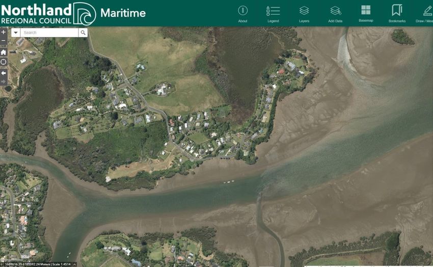
27 May 2021

several recreational maritime users who have been unsuccessful in gaining improved public
access and use of the area. Other than serving a full-service marina the ramp is also used
for vessel haulout and maintenance. It also services a large active youth sailing club and the
Kerikeri High School sailing team and program. All these activities take place across the
ramp creating a number of operational safety issues given the variety of users and uses.
Discussions with the Club were held to look at improving public access through undertaking
further development of the surrounds of the marina, however these were unsuccessful
mainly due to the cost of any development - estimated at $10-15M which would need to be
re-couped commercially and would therefore conflict with the Cruising Clubs stated intent
and would impact on the Cruising Clubs infrastructure necessitating further investment to
compensate the Club.

                                                    Existing Boat Ramps

Figure 2 – Doves Bay (Kerikeri Cruising Club and Marina) and Opito Bay

Figure 3 – Location of Doves and Opito bays

                                                                                                 3
27 May 2021

3.3 Opete Creek

This site was identified by a member of the public as worthy of investigation in 2020. The site
was for sale and was suggested as a possible option for any new development.
The site is more than 24 km from Kerikeri on predominantly unsealed road. As well as a
distance barrier the site would require significant improvement in terms of infrastructure
which would be in addition to any purchase price. Any access would be limited by tide for
most boats.
Initial discussions with iwi have suggested that local hapu are not supportive of intensive
development on the Purerua Peninsula.
Due to the significant distance on unsealed roads and a lack of support this option was
discounted at this time.

                                                          Opete Creek

Figure 4 – location of Opete Creek

                                                                                                  4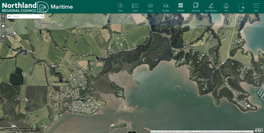
27 May 2021

Figure 5 – Opete Creek

3.4 Skudders Beach

Skudders Beach is a small settlement approximately seven km from Kerikeri. The proximity
to Kerikeri would make the site attractive but the distance for boats to travel to the open bay
under the five knot restrictions make this site less attractive than sites further out. The tidal
nature of the inlet at Skudders Beach would also mean that significant investment in
structures would be required and the narrow nature of the channel at this point would pose a
navigation safety issue from any structures installed to maintain all tidal access. The cost of
infrastructure and limited access to the water make this option unfavourable at this time.

                                                                                                    5
27 May 2021

Figure 6 – Skudders Beach

3.5      Waipapa Landing

Waipapa Landing is approximately 5 km from Kerikeri but similar to Skudders Beach the
distance for boaties to travel under the five knot restrictions make this site less attractive
than options further into the bay.
Waipapa landing is an existing boat ramp facility with an all tide ramp and launching pontoon.
The limitation with this site is a lack of opportunity for expansion with no space to grow or to
establish additional car parking. This coupled with the distance to travel make this site
unsuitable for expansion.

                                                                                                   6
27 May 2021

3.6      Rangitane Reserve

Rangitane Reserve is Department of Conservation land accessible from Opito Bay Road just
past the Rangitane turnoff. It attractive as a development site in that it is close to the main
access points in the Bay but is limited in that access to deep water is difficult and therefore
expensive, it is immediately adjacent to an oyster lease and gaining approval to develop
DOC land would be protracted and by no means assured.

Figure 8- Rangitane Reserve

3.7      ‘Reedy’s’

‘Reedy’s is a private property located at the northern end of the peninsula. It was suggested
as an option when the property came up for sale in 2019. While the site has the desired
attributes of closeness to the bay the cost of purchase (estimated at over $5m) and the cost
of providing access infrastructure, parking and launching facilities makes this site
unaffordable.

                                                                                                  7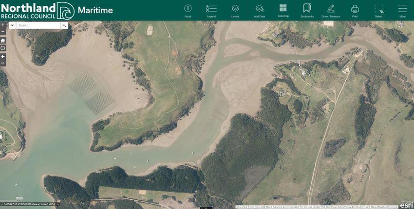
27 May 2021

Figure 8 – ‘Reedy’s’

                       8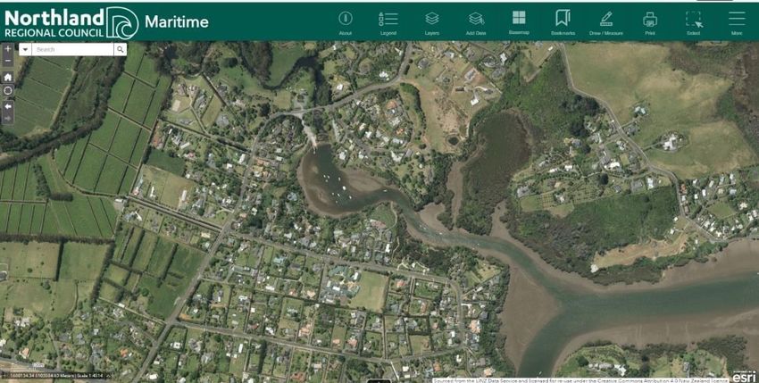
27 May 2021

KERIKERI INLET (BAY OF ISLANDS) RECREATIONAL BOAT LAUNCHING FACILITY OPTIONS ANAYLSIS

Project Objective: To improve coastal access for communities within the Kerikeri Inlet to cater for growing recreational boating demand for access to the Bay of Islands

Criteria Analysed:

    1.    The extent to which adjacent public land is available or there is an opportunity to reclaim land.
    2.    The extent to which the facility maximises boat launching and carparking facilities accessible to the Kerikeri growth centre
    3.    The extent to which the facility is close to (within a 10km radius) the population growth centres of Kerikeri and Waipapa)
    4.    The extent to which the facility minimises environmental impact including marine ecology and local terrestrial vegetation and fauna habitat, particularly for Kiwi
    5.    The extent to which the existing road network can provide suitable access for additional traffic movements associated with cars and boat trailers
    6.    The extent to which the facility is located away from sensitive land use activities
    7.    The extent to which noise arising from construction and operational use of the facility can be minimised or avoided
    8.    The extent to which the facility supports the cultural environmental values and objectives of local mana whenua
    9.    The extent to which providing the facility is within the financial capability of Far North district Council
    10.   The extent to which the facility contributes to the economic well-being of the Far North District, including employment opportunities and downstream economic benefits
    11.   The extent to which the facility contributes to social well-being of the Far North District and the immediately adjacent recreational boating community of Kerikeri
    12.   The extent to which the facility eases demand on other existing boat ramp facilities

                                                                                                                                                                                   9
27 May 2021
OPTION NAME COMMENT
KERIKERI CRUISING CLUB AND
MARINA (DOVES BAY)
Option Description This privately owned site at Opito Bay Road is the location of the Kerikeri Cruising Club and Marina where there is an existing reclamation and marina facility. The marina accommodates 106 marina
berthed boats and 35 pile moorings. The facility also includes dinghy storage and a double width public boat ramp facility at the eastern end. There is also a single width ramp at the western end of
the car park suitable for dinghy launching. There are 19 car and trailer carparks on the site. The KKCC also use the boat ramp for launching small yachts for its youth-based sailing activities. The site
is accessed via a two-lane private access road that has access from Opito Bay Road and is suitable only for single axle trailers due to its narrow width. The site is situated at the outer end of the
Kerikeri Inlet and is within 15minutes motoring of central Bay of Islands recreational fishing and boating locations.
Location Factors (criteria)
Land Availability and/or The existing land area is occupied by carparking and vehicle manoeuvring areas. Existing topography would limit the ability to extend the landward side of the marina to incorporate additional
reclamation requirement carparking. The seaward side is occupied by marina berths and pole and swing moorings for the entire length of Cruising Club facility. Without significant cost and agreement from the landowner,
there is no ability to reclaim additional land for carparking and access to the boat ramp facility.
Public road access and potential Private road access suitable for Single axle trailers only. Public access enabled by way of a condition of resource consent only. Other potential access points from Anchorage Heights Road down to the
parking availability marina but not readily available as requires access down through steep private land.
Proximity to population Located near Opito Bay, approximately 20 minutes drive from Kerikeri.
centre(s)
Proximity to sensitive adjacent Appletree Bay nearby. Would result in loss of a small beach. Visual impact/change for those residential properties overlooking the Cruising Club
land uses
Proximity to existing marine 106 berth private marina with 35 pile moorings. Marina land-based facilities built on an existing reclamation.
activities (e.g. moorings, marine
farms)
Potential Facility Capacity No space for expansion. Development would displace moorings and marina berth areas. Possible expansion into adjacent Apple Tree Bay previously investigated and not viable due to topography and
ecology constraints.
Ecological Impacts Kiwi zone nearby. Extensive and vulnerable kiwi movement corridor along the entire length of Opito Bay road. Area listed as a proposed Significant Natural Landscape area by FNDC.
Cultural Impacts Club have a good relationship with Ngati Rehia who have supported development in the past. The marina is a source of kaimoana
Economic Impacts Cost to construct a new access road. Loss of existing moorings and relocation costs. Additional use demand on existing facility which could diminish operational functionality of existing activities
Marine Navigation Safety Existing swing and pile moorings potentially displaced and needing to be relocated.
Impacts
Tidal/Wind Influence Boat ramp location within a sheltered in bay. All weather, all tide access.
Multi-user conflict potential Swing and pile moorings in the way. Learn to sail activities.
Construction Feasibility Factors Existing access road to marina is private. A new private road to service the development would be required. Cruising club have a limit on the amount of public facilities they will provide- club designed
for members. Disruption to existing marine facilities during construction period. Costs to build new access road, reclamation and infrastructure suggest a cost at somewhere over $3.7M
1027 May 2021
OPETE CREEK
Option Description This site is located at Opete Creek which is approximately 24km from Kerikeri township via Puerura, Rangihoua and Hansen Roads. It is accessed via private land with no established public access.
The boat ramp facilities at this site are undeveloped. The marine location is extremely tidal with limited access to deep water. It is located a similar distance to the entrance to the Bay of Islands
marine area as the Rangitane option.
Location Factors
Land Availability and/or Site was for sale in 2020 and was recommended by a member of the Rangitane Residents Association as a suitable alternative to Rangitane
reclamation requirement
Public road access and potential Purerua Road beyond Bay of Islands Academy School is a gravel road as is Rangihoua Road through to Hansens Road, which is poorly maintained and narrow. There is no existing public access from
parking availability the end of Hansens Road to the coast. Road easement / paper road may be available.
Proximity to population Significant distance from target population centres. Approximately 30 km or 40 minutes drive from the Kerikeri and Waipapa Urban centres and much of the access is over gravel road, and is
centre(s) therefore unlikely to be highly utilised.
Proximity to sensitive adjacent Large private residences and luxury tourist accommodation located in close proximity to Mataka Estate gated community
land uses
Proximity to existing marine Oyster farms and moorings nearby.
activities (e.g. moorings, marine
farms)
Potential Facility Capacity Limited land area for parking
Ecological Impacts Unknown
Cultural Impacts Local Iwi are not supportive of development in this location.
Economic Impacts Higher construction costs for transport of materials. Cost to purchase private land/ easements. Too far away from main population centres for some members of the community to access given fuel
costs etc.
Marine Navigation Safety Moorings nearby. Limited depth, may require dredging or be only half tide access.
Impacts
Tidal/Wind Influence Sheltered bay but not accessible at all tides
Multi-user conflict potential Oyster farms, private residential land
Construction Feasibility Factors Would need to upgrade and seal road. Costs to improve 14 km of unsealed road and establishing infrastructure and all tide access suggest costs in excess of $3.8M
1127 May 2021
OPITO BAY
Option Description This site is located at 4 Tikorangi Road, Opito Bay. It is a 4m wide public boat ramp facility situated at the northern end of the Opito Bay beach. The beach itself is a crescent shaped bay that includes
over 60 swing moorings. It is one bay north of the Doves Bay Marina facility. Recreation reserve and road-side public carparking for 18 cars and trailers is located on either side of the road. There is a
small residential settlement of approximately 30 houses located on the hills above the bay and adjacent to the lower northern side of the road. Opito Bay is the terminus of Opito Bay Road that
provides road access to the Opito Bay peninsula. The Opito Bay boat ramp is the closest boat ramp to the Bay of Islands maritime recreational area.
Location Factors
Land Availability and/or There is very limited existing land availability for the expansion of carparking facilities at Opito Bay. Apart from the existing reserve land which is also a popular picnic and beach swimming
reclamation requirement destination, there is no public land available. Adjacent land to the north is privately owned residential land. Land reclamation opportunities are limited due to the location of existing swing moorings
and the potential adverse impact on a popular beach swimming destination.
Public road access and potential Corners on road. Parking would be limited without expensive reclamation. Opito Bay Road terminates at this settlement with no provision for through road traffic. Limited manoeuvring space
parking availability
Proximity to population Approximately 13.5 km or 20 minutes from Kerikeri
centre(s)
Proximity to sensitive adjacent Popular swimming beach - one of only three publicly accessible beaches within a 20km radius of Kerikeri township. Part of this would be lost if reclaimed. Established residential area where the
land uses majority of houses would have views of the bay and reclamation area.
Proximity to existing marine Swing moorings nearby and in close proximity to the beach. Any reclamation would necessitate removal of moorings
activities (e.g. moorings, marine
farms)
Potential Facility Capacity Limited without impact on existing moorings
Ecological Impacts Some mature Pohutukawa trees would have to be removed to make this viable.
Cultural Impacts Local Iwi are not supportive of reclamation on this site.
Economic Impacts High construction costs for a reclamation, removal of existing swing moorings, and negative effect on nearby property values.
Marine Navigation Safety Large number of swing moorings would need to be removed/ relocated.
Impacts
Tidal/Wind Influence All weather, all tide access
Multi-user conflict potential Site popular with swimmers and beach users, as the closest swimming beach to Kerikeri. Displacement and disturbance to swing moorings. Aquaculture (oyster farming) use of the boat ramp for off-
loading onto trucks.
Construction Feasibility Factors Limited access along narrow roads to deliver construction materials. Barging may be necessary. Noise and visual disturbance adjacent neighbours Costs to improve the access road, create
reclamation and ancillary infrastructure suggest costs of more than $2M
1227 May 2021
KURAPARI ROAD
Option Description This site is located within private property at 51A Kurapari Road, Kerikeri located off Rangitane Loop Road. The boat ramp location on this site could be approximately 100m downstream from an
existing private jetty.
Location Factors
Land Availability and/or Land access to a boat ramp location is via private land valued at over $3M. Reclamation may or may not be required given proximity to Kerikeri River channel. Land requirements for access road,
reclamation requirement parking and manoeuvring areas.
Public road access and potential Unsealed road, narrow and poor visibility.
parking availability
Proximity to population Site has a similar proximity to Kerikeri as Rangitane. (approximately 13.5 km)
centre(s)
Proximity to sensitive adjacent Limited adjacent land use activities. Existing residences on large lot properties either side and Maori reserve to the north-west
land uses
Proximity to existing marine Existing pile mooring
activities (e.g. moorings, marine
farms)
Potential Facility Capacity
Ecological Impacts Intertidal marine ecology would need to be considered. Area supports kiwi population
Cultural Impacts Adjacent to Maori reserve with little support from Ngati Rehia to locate in this part of the Kerikeri Inlet
Economic Impacts Land acquisition would be expensive, as would provision of car parking and sealing road.
Marine Navigation Safety Narrow channel and tidally restricted- could only practically be accessed near high tide. Significant dredging required to make this accessible.
Impacts
Tidal/Wind Influence Relatively exposed to the prevailing south-westerly wind
Multi-user conflict potential Limited
Construction Feasibility Factors Neighbours oppose project. Would have to take land under the PWA and do significant road upgrades. Water access limited as shallow with narrow channel.
1327 May 2021
REEDY’S
Option Description Across the land from Opito Bay
Location Factors
Land Availability and/or Site was for sale 2020. Estimated cost of land $5M
reclamation requirement
Public road access and potential Difficult access down a steep grade would be expensive to create, limited land area for parking.
parking availability
Proximity to population Around 13 km or 20 minutes from Kerikeri
centre(s)
Proximity to sensitive adjacent Located in a bush area. Land surrounding existing house is classified as a Significant Natural Landscape area on council maps. Also zoned as a high natural character area. This may make formation of a
land uses suitable access road difficult.
Proximity to existing marine No nearby marine activities present.
activities (e.g. moorings, marine
farms)
Potential Facility Capacity Limited area to work with making for a limited amount of parking
Ecological Impacts Kiwi population area
Cultural Impacts Iwi have been opposed to development up the Manganui inlet.
Economic Impacts Would need to purchase land and demolish the house. Likely to require public works act process.
Marine Navigation Safety N/A
Impacts
Tidal/Wind Influence Exposed to northerly storms
Multi-user conflict potential No
Construction Feasibility Factors Access difficult given topography and bush area, limited space to use. Costs to build access road through difficult topography and create parking would indicate a significant cost. Add to this land
acquisition of perhaps $5M indicate a cost of over $8M
1427 May 2021
RANGITANE DOC RESERVE
Option Description Access off Opito Bay Road between Opito Bay and Rangitane
Location Factors
Land Availability and/or Access is through Conservation land along a partly formed access used by Oyster farms. Access to deeper water is very limited due to large tidal flats. Reclamation and dredging would be required.
reclamation requirement
Public road access and potential Access is down a steep incline with no flat land at the base. Topography not suitable for parking.
parking availability
Proximity to population Approximately 13 km to Kerikeri
centre(s)
Proximity to sensitive adjacent Access is through Department of Conservation reserve
land uses
Proximity to existing marine Immediately adjacent to Oyster farm in the bay
activities (e.g. moorings, marine
farms)
Potential Facility Capacity Very limited area available necessitating some form of reclamation
Ecological Impacts Kiwi Population area. Mangrove clearance required. Located adjacent to Aroha Island.
Cultural Impacts Possible support as is close to proposed Rangitane development
Economic Impacts Access to DoC land would be potentially prostrated
Marine Navigation Safety nil
Impacts
Tidal/Wind Influence Sheltered.
Multi-user conflict potential Ramp occupied by Oyster Farmers during loading/ unloading. Conflict during peak summer period and may create H&S issues.
Construction Feasibility Factors Access difficult through conservation area, limited areas. Costs to establish road access and reclaim land and dredge all tide access indicate costs in excess of $2.7M
1527 May 2021
RANGITANE LOOP ROAD
(Preferred Option)
Option Description This site comprises the existing boat ramp facility at Rangitane Loop Road that is owned and operated by Far North Holdings Limited on behalf of Far North District Council. There is an existing boat
ramp and derelict jetty facility at the site. The boat ramp entrance and minimal car and trailer parking is located within the road reserve. The ramp and jetty are within the CMA. The Rangitane Loop
Road reserve continues east and west of the boat ramp and comprises the coastal margin. Crown owned reserve land is located further to the north. The site is adjacent to the Rangitane Coastal
Residential community that overlooks the site.
Location Factors
Land Availability and/or Existing single ramp and consented jetty (requiring significant work). Limited existing parking on the road shoulder and no safe manoeuvring space for trailers to use the ramp, indicating reclamation
reclamation requirement would be needed.
Public road access and potential Two lane sealed road adjacent to site.
parking availability
Proximity to population Within the village of Rangitane. Approximately 13 km from Kerikeri
centre(s)
Proximity to sensitive adjacent Immediately adjacent to three residential properties which would overlook the site.
land uses
Proximity to existing marine Adjacent to nine swing moorings of which three are directly adjacent to proposed development and could require relocation. End of 5 knot zone within 100m of the site, and within close proximity to
activities (e.g. moorings, marine the popular fishing areas.
farms)
Potential Facility Capacity Reclamation parking space limited is limited, however the nearby reserve would be utilised during peak summer periods to support overflow parking.
Ecological Impacts Rock armouring would provide a shellfish habitat and could lead to population increases of some species which would be a benefit.
Cultural Impacts Ngati Rehia and local kaitiaki supportive of the project
Economic Impacts Construction costs for reclamation
Marine Navigation Safety Channel narrows at low tide directly upstream from site.
Impacts
Tidal/Wind Influence Exposed to easterly storms
Multi-user conflict potential Existing launching facility, residential area nearby.
Construction Feasibility Factors Transport of construction materials through residential area.
1627 May 2021
Skudders Beach
Option Description This site located at Skudders Beach and would be accessed from the end of Skudders Beach Road. It is not far from Waipapa Landing and located well up the Kerikeri Inlet within the maritime 5 knot
speed limit zone.
Location Factors
Land Availability and/or No land available so would require reclamation
reclamation requirement
Public road access and potential FNDC owned 2 lane sealed roads service the site, limited turning space.
parking availability
Proximity to population Located very close to town. Approximately 6 km from Kerikeri
centre(s)
Proximity to sensitive adjacent Established residential area with neighbouring houses at the same elevation as the site. Noise and visual impact.
land uses
Proximity to existing marine Pile moorings located nearby. Any reclamation would require removal of existing moorings
activities (e.g. moorings, marine
farms)
Potential Facility Capacity Limited to size of reclamation, as no opportunity for overflow parking nearby.
Ecological Impacts Existing mooring area
Cultural Impacts Maori land block located nearby. Ngati Rehia very opposed to project.
Economic Impacts Construction costs of reclamation, possible decrease in property values for neighbours.
Marine Navigation Safety Very narrow channel, effect on hydrology and current flow if reclamation built.
Impacts
Tidal/Wind Influence Relatively sheltered
Multi-user conflict potential Residential area
Construction Feasibility Factors Reclamation would need to be twice the size as Rangitane. Poor Geotech conditions. Silty. Long distance to the channel. Costs to reclaim land and create infrastructure and potential land acquisition
suggest costs of $3.3M
1727 May 2021
Waipapa Landing
Option Description This site is located at the upper end of the Kerikeri Inlet within the arm that is accessed from Landing Road. It is over 5km from the boat ramp to the Inlet entrance to the Bay of Islands. A large
proportion of this route is within the maritime 5 knot speed limit. A large number of residential homes have CMA frontage to this route. There is an existing concrete boat ramp and jetty/floating
pontoon at this location with limited use 2 hours either side of high tide. There is carparking for 12 cars and trailers. The carparking and boat ramp facility is within the existing Landing Rd road
reserve.
Location Factors
Land Availability and/or No land area available – would require reclamation
reclamation requirement
Public road access and potential Direct access to Landing Road, a sealed 2 lane FNDC road, with good site lines.
parking availability
Proximity to population 4.5 km from Kerikeri
centre(s)
Proximity to sensitive adjacent Popular swimming spot located adjacent to boat ramp. Neighbouring properties are located at a higher elevation than the site so not as impacted by visual and noise.
land uses
Proximity to existing marine Existing moorings would need to be removed for reclamation- Waipapa Landing is a popular area for boat owners to live aboard their vessels due to the sheltered environment and close proximity to
activities (e.g. moorings, marine infrastructure.
farms)
Potential Facility Capacity Limited to size of reclamation
Ecological Impacts Waipapa River discharges here, with large volumes of water entering the basin during storm events. Reclamation likely to create a choke point, increase turbidity in the area and increase flood risk.
Detailed hydrology assessment required.
Cultural Impacts Unknown.
Economic Impacts Costs for people who live aboard their boats to find new moorings in alternative locations. Cost of constructing the reclamation and associated flood mitigation works that would be required.
Marine Navigation Safety Significant distance from 5 knot zone to open water- current lack of compliance is an issue. Very tidally restricted due to sedimentation in the navigation channel.
Impacts
Tidal/Wind Influence Very sheltered
Multi-user conflict potential Popular swimming area adjacent to ramp.
Construction Feasibility Factors Limited manoeuvring space onsite. Costs to acquire land and reclaim indicate costs of perhaps $3.9M
18You can also read