EASY WALKS & HIKES

                      ...natural Mente !!

34 easy itineraries
←
→
Page content transcription
If your browser does not render page correctly, please read the page content below
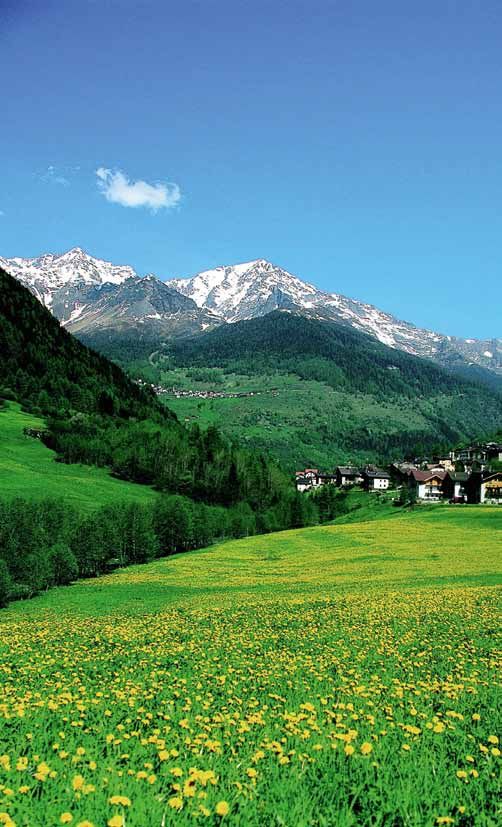
EASY WALKS & HIKES
...natural Mente !!
34 easy itineraries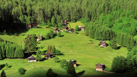
INDEX                        CALDES
                             1. The Rocca di Samoclevo
                                                                                                 Page
                                                                                                    2

                             MALÉ
                             2. The Birreria and the Léc’                                           2
                             3. Parco Regazzini and the pine forest                                 3

                             VAL DI RABBI
                             4. Rabbi Fonti - Segheria Veneziana - Malga Fratte                     3
                             5. San Bernardo - Valorz                                               4
                             6. Piazzola - Fontanino - Saent waterfalls                             4

                             DIMARO - FOLGARIDA
                             7. Dimaro - Costa Rotian - Val Meledrio                                5
                             8. Folgarida - Val Meledrio                                            5
                             9. Folgarida - Malghet Aut - Monte Vigo                                5

                             COMMEZZADURA
                             10. The hamlets of Commezzadura                                        6

                             MEZZANA - MARILLEVA
                             11. Mezzana - Church of San Pietro & San Paolo and the Madonna del
                             Caravaggio shrine - Waterfalls                                         6
                             12. Mezzana - Sports Complex area - Ortiöi                             7
                             13. Marilleva 900 - Gagioi - Training course                           7
                             14. Marilleva 1400 - Albarè/Valussaia with training course             8

                             PELLIZZANO
                             15. Fazzon (Lago dei Caprioli)                                         8
                             16. Fazzon (Lago dei Caprioli) - Malga Alta                            8

                             OSSANA
                             17. Valpiana - Malga Valpiana - “Sas Pisador” waterfalls               9
                             18. Fazzon (Lago dei Caprioli) - Valpiana                              9
                             19. Sentiero de la Léc’ trail - Valpiana                              10

                             VAL DI PEIO
                             20. Cogolo - Church of Santa Lucia                                    10
                             21. Cogolo Loc. Pegaja - Tour of the “masi”                           10
                             22. Peio Fonti - Wildlife area - Peio Paese                           11
                             23. Peio Fonti - Forte Barba di Fior                                  11
                             24. Peio Paese - Lago Covel                                           12
                             25. Peio Paese - Malga Talè                                           12

                             VERMIGLIO
                             26. Laghi di S. Leonardo at the Centro Fondo                          13
                             27. Laghi di S. Leonardo - Palù waterfall                             13
                             28. Cortina - Via dele Pendege (Via del Sant)                         14
                             29. Baita Velon - Passeggiata delle Viscle                            14

                             PASSO TONALE
                             30. Presena Glacier                                                   15
                             31. Val Presena (Raseghe area and a small “beach”)                    15
Itineraries for strollers,
                             32. Alveo del Presena                                                 16
also on unpaved roads        33. The San Bartolomeo Hospice - Forte Mero - Valbiolo Restaurant     16
                             34. Tonale - The Tonale Biotopo Torbiera (peatbog biotope)            17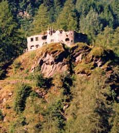
Legend
 1. Caldes - The Rocca di Samoclevo

 2. Malé - The Birreria and the Léc’
 3. Malé - Parco Regazzini and the pine forest

 4. Rabbi Fonti - Segheria Veneziana - Malga Fratte
 5. San Bernardo - Valorz
 6. Piazzola - Fontanino - Saent waterfalls

 7. Dimaro - Costa Rotian - Val Meledrio

 8. Folgarida - Val Meledrio
 9. Folgarida - Malghet Aut - Monte Vigo

10. Commezzadura - The hamlets of Commezzadura

11. Mezzana - Church of San Pietro & San Paolo and the
    Madonna del Caravaggio shrine - Waterfalls
12. Mezzana - Sports Complex area - Ortiöi
13. Marilleva 900 - Gagioi - Training course
14. Marilleva 1400 - Albarè/Valussaia with
    training course

15. Pellizzano - Fazzon - (Lago dei Caprioli)
16. Pellizzano - Fazzon - (Lago dei Caprioli) - Malga Alta
17. Pellizzano - Fazzon (Lago dei Caprioli) - Valpiana

18. Ossana - Valpiana - Malga Valpiana - “Sas Pisador” waterfalls
19. Ossana - Sentiero de la Lec - Valpiana

20. Cogolo - Church of Santa Lucia (Comasine)
21. Cogolo - Tour of the “masi”

22. Peio Fonti - Wildlife area - Peio Paese
23. Peio Fonti - Forte Barba di Fior
24. Peio Paese - Lago Covel
25. Peio Paese - Malga Talè

26. Vermiglio - Laghi di S. Leonardo at the Centro Fondo
27. Vermiglio - Laghi di S. Leonardo - Palù waterfall
28. Vermiglio - Cortina - Via dele Pendege (Via del Sant)
29. Vermiglio - Baita Velon - Passeggiata delle Viscle

30. Passo Tonale - Presena Glacier
31. Passo Tonale - Val Presena (Raseghe area and a small “beach”)
32. Passo Tonale - Alveo del Presena
33. Passo Tonale - The San Bartolomeo Hospice - Forte Mero -
    Valbiolo Restaurant
34. Passo Tonale - The Tonale Biotopo Torbiera (peatbog biotope)

Naturally... we use recycled paper

Created by: Editoria APT Val di Sole
Text: R. Delpero & A. Penasa - Cover photo: Mochen T.
Photos: Stelvio National Park Archives, D. Andreis, S. Andreis,
A. Banal, G. Bernardi, M. Bertolini, G. Borghesi, I. Callegari, A. Dalpez,
T. Mochen, M. Simonini, S. Tomasini, L.Tonina, V. Veneri, R. Zambotti,
APT Val di Sole Archives
Ed. 07/2013 - printed by Esperia srl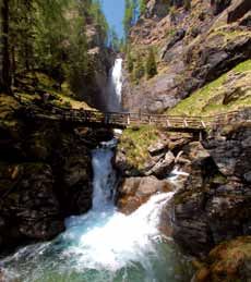
1 CALDÉS The Rocca di Samoclevo
The Rocca di Samoclevo (stronghold - 983 m) can be reached in half an hour along a mule
track starting from just above the town of Samoclevo (774 m). The first nucleus of the fort
was built before the 13th century, therefore before the Caldés Castle, and probably served
as a military stronghold to keep watch over the surrounding roads. What remains today
is a quadrangular keep inside a walled enclosure and near it the ruins of a Gothic chapel
and remnants of a fresco. The residential section, which is also ruined, was apparently
added in the 14th century. The Prince Bishops and the Counts of Tyrol often contended
for the Rocca and it was also the site of a number of armed conflicts. It was the home of
the Caldèsios, later passing into the hands of the Cagnò family and finally to the Thun
family. It served as the centre of the judicial jurisdiction of the Val di Rabbi. A number
of rural buildings and country dwellings were built alongside it in the 19th century by
farmers, who are the current owners. Since February 2006 the castle is under supervision
of the Trentino Heritage Office (Soprintendenza trentina). Time: approx. 40 minutes.

    2 MALÉ The Birreria and the Léc’
From the stone arch on the edge of the town of Malé, in the direction of Trento, take the
SP 141 road for Bolentina and Montés as far as the first bend. Turn right onto a narrow
unpaved road and continue for about 100 m before turning left, slightly uphill, and follow
the wide even road for Val di Rabbi as far as the area and building called Birreria (brewery)
on the bridge over the Torrente Rabbiés (stream). Excellent beer was once produced in this
building starting from the end of the 19th century. The road follows the line of an irrigation
canal through the fields around Malé, known in dialect as the léc’. Time: approx. 1 hour.
After the bridge over the Torrente Rabbies, follow the provincial road to the left for about
400 m until you reach the Mulino Ruatti, a historical watermill that was built at the beginning
of the XIX century, that has been carefully rebuilt and is now fully functional giving visitors the
chance to learn more about how life was in a mill. There is an entrance fee to visit the mill.

2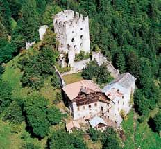
3 MALé Parco Regazzini and the pine forest
Near the church of San Luigi Gonzaga and the building of the “Comunità della Val
di Sole”, there is a road that goes downwards and passes under the SS 42 state road
and then takes you across the bridge located over the Noce River until you reach the
area called “ai Molini”. On the right, there is a “Venetian” (water-powered) sawmill
that was in operation up until 1978 and has now been opened to the public for display
purposes during the summer months. Continue uphill from the sports complex to the
wooded area of the Parco Regazzini, equipped with a fitness trail and other facilities.
Return, descending via the cement bridge known as the Passerella (its name comes
from the fact that it was once only an unstable wooden passageway over the river)
located high above the rapids of the Noce River which is known for canoeing, kayak
and rafting descents. From here you can cross through the pine forest, then through
the playground and after going past the cemetery you will reach the centre of the
town of Malé. Time: approx. 45 minutes.

 4 VAL DI RABBI Rabbi Fonti - Segheria Veneziana -
                                  Malga Fratte
From the parking area in the location called Plan (1252 m) take the forest road to the
traditional Segheria Veneziana “Bègoi” (water-powered sawmill - 1285 m). Climb up
through the woods along a path to the Malga Fratte Bassa (mountain dairy - 1482
m), from where you can enjoy a view of the Valle di Saent and the foaming waterfalls
with same name. Then go down along the forest road to the bridge over the Torrente
Ragaiolo, where there is a small spring of chalybeate water. A small detour, along a
winding yet pleasant trail that goes upwards from the other side of the bridge, will
take you to a panoramic point with a spectacular view of the Cascata del Ragaiolo
(waterfall). The return route leads back in the direction of the Segheria Veneziana,
along a small path to the right then across a bridge and down the forest road to the
Plan parking area.
Time: 2 hours 30 minutes.

                                                                                     3
5 VAL DI RABBI San Bernardo - Valorz
From the town of San Bernardo (1098 m), the administrative centre of Val di Rabbi,
descend to the bridge over the Torrente Rabbies. Follow the narrow paved road that
takes you past the Rio Valorz, and then take the forest road on the right side of the
valley, which is one of the best-known images of the Trentino region. At first, this
forestry road goes upwards past several meadows and typical masi or rural dwellings,
and then through a larch wood to the first bridge on the river. From here, continue
up the right side of the valley along a path to Malghetta (1364 m), at the foot of the
spectacular Valorz waterfalls. Round trip time: 2 hours 30 minutes.

    6 VAL DI RABBI Piazzola - Fontanino - Cascate di Saènt
From the parking area at the location called Coler (1380 m), on foot, or in the summer
with a shuttle bus service, go to Malga Stablasolo (a mountain dairy - 1539 m) a
unique and typical place to stop and have something to eat. Continue along the
forest road, go over the bridge on the Torrente Rabbies and you will reach the first
waterfall. Follow the trail up to the well-known bridge in front of the second waterfall,
a bubbling, spectacular sight (a panoramic point - 1750 m). Continue onwards until
you reach the n. 106 trail, from here go down to Malga Stablet (a visitor’s centre of the
Stelvio National Park concerning the life of the marmot). Then, back onto the forest
road that leads to Malga Stablasolo.
Time: 1 hour 30 minutes with the shuttle bus, or 2 hours on foot.

4
7 DIMARO Costa Rotian - Val Meledrio
At the beginning of Via Gole (street) in Dimaro take the shortcut to the Folgarida
resort: you will first arrive at the Bonetei area and then continue to the area called
“Le Sort” (940 m) as far as the Costa Rotian junction. Time: approx. 40 minutes. This
walk can be extended by crossing the provincial road and continuing along the easy
Lèc’ trail (dialect term of an irrigation channel), through the lovely Val Meledrio in
the Adamello Brenta Nature Park, until you reach the calcara, which was used as a
lime kiln in the past. Continue along the unpaved road towards the town of Dimaro,
alongside the Meledrio stream, and in 15 minutes you will reach the “maglio”, an
ancient forge. To reach Dimaro, continue onwards until you reach the provincial road
that goes to Folgarida and after crossing over a small bridge you will reach the first
homes in the town. Time: approx. 1 hour 30 minutes.

 8 FOLGARIDA Val Meledrio
To the left of the Hotel Belvedere in Folgarida, take the “Ronzola” trail down to the
bridge called “Pont del Pastin” (1213 m). Continue left along the mysterious and densely
wooded Val Meledrio to the waterfall on the Torrente Pison (stream), followed by the
characteristic Capitello della Madonnina (small shrine). Time: 1 hour 30 minutes.

 9 FOLGARIDA Malghet Aut - Monte Vigo
Close to the gondola lift station in Folgarida (1300 m), hike up to the area called
Malghet Aut (1856 m), first along the forest road and then along a trail (or you can
also take the gondola lift up). Time: approx. 1 hour. Follow the trail up to Monte Vigo
(2180 m) another hour. From the nearby Rifugio Orso Bruno you can walk down along
the SAT 201 trail to the lovely lake called Lago delle Malghette (1889 m).
Time: approx. 30 minutes.

                                                                                      5
10 COMMEZZADURA The hamlets
                                         of Commezzadura
From the Town Hall Square in Mestriago take the wooden footbridge across the
Noce River and turn right onto the narrow road climbing towards the hamlet of
Daolasa and the “Piazzetta dei Garbei” (small square). From here, turn right along
the municipal road leading to the hamlet called Piano and follow the flat trail until you
reach the bridge, then enter into Piano. Climb up the “Via del Capitel” as far as the
by-pass, then take the trail leading to the 15th century church of Sant’Agata, one of
the loveliest spots in all of Val di Sole. Follow the sidewalk back to Mestriago. With a
stroller, you can only go as far as the hamlet called Piano.
Easy itinerary – Time: approx. 45 minutes.

11 MEZZANA Church of San Pietro and San Paolo and the
                           Madonna del Caravaggio shrine - Waterfalls
In the town of Mezzana go upwards along Via Garibaldi street (to the right of the
Cassa Rurale Bank) to Piazza Trento (square) where you will find the 15th century
parish church dedicated to San Pietro and San Paolo, with its splendid wooden altars,
as well as the Madonna di Caravaggio shrine, a beautiful example of 18th century
architecture. Continue to the left, across the Rio Spona (stream) to Piazza della
Novalina. From here continue along the road called the “Plazöle” and after 500 m
turn right until you reach the waterfall. Easy itinerary – Time: approx. 30 minutes.

6
12 MEZZANA Sports Complex area - Ortiöi
An easy walk along the Campo di Canoa (canoe park, on the left bank of the Noce
River) – approx. 15 minutes. Near the Sports Complex in Marilleva 900, take the trail
leading up to the mountain shelter called Maso Aucela (SAT 202 trail to Maso Redolfi,
Maso Aucela and from there back to the Sports Complex).
Time: approx. 20 minutes.

13 MARILLEVA 900 Gagioi - Training course
Beyond the gondola lift station in Marilleva 900, take the narrow paved road on the
right that climbs towards the Residence Amba and Residence Garden accommodation
facilities. Continue onwards until you reach a clearing; from here, go right, in order to
reach a picnic area (1000 m). Time: approx. 30 minutes. If instead you continue along
a rather steep forest road (SAT 201 trail), you will reach Marilleva 1400.
Time: 1 hour 30 minutes.

                                                                                       7
14 MARILLEVA 1400 Albarè/Valussaia with
                                        training course (1395 m)
You can access the course from just above the Residence Lores (beyond the Valtur
Village). Cross the Ponte Basso bridge (1441 m) over the Rio Lores. The course features
gymnastic equipment and continues into a thick fir wood. There are a number of
tables and benches along the way.
Time: approx. 30 minutes.

15 PELLIZZANO Fazzon (Lago dei Caprioli)
The trail begins at the first bend along the paved road that from Pellizzano leads to
the famous lake called Lago Fazzon (1321 m), better known as Lago dei Caprioli (lake
of the roe deer). From the wooden bridge over the Rio Fazzon, climb up into the
woods along the trail called “percorso degli Gnomi” and follow the “Sentiero della
Palù” signposts. Time: approx. 50 minutes.

16 PELLIZZANO Fazzon (Lago dei Caprioli) - Malga Alta
Drive up to the area called Fazzon (or walk up along the Palù trail starting from
Pellizzano) until you reach a pay car-park. Near the car-park, take the SAT 203 trail.
This easy trail leads up to a height of 1546 m and the Malga Alta (Alpine dairy).
Time: 1 hour.

8
17 OSSANA Valpiana - Malga Valpiana - “Sas Pisador”
waterfalls
You can reach the Rifugio Valpiana mountain hut (1211 m) by car from the town of
Ossana (pay car-park). Continue on the forest road along the wide valley and the
banks of the Torrente Foce (stream). When you reach the Malga Valpiana Alpine dairy
(1311 m), follow the trail for the “Sas Pisador” waterfalls and the nearby rock climbing
wall. When you reach the junction with the trail for the “J. Canali” bivouac, keep left
and return in the direction of the Rifugio Valpiana, thus completing an interesting
loop. Time of the entire itinerary: 1 hour.
Malga Valpiana is open from June to September, local dishes are prepared here.
18 OSSANA Fazzon (Lago dei Caprioli) - Valpiana
From the Malga di Fazzon Alpine dairy (ASUC Pellizzano Visitor Centre 1279 m) take
the forest road on the right, which passes through the thick fir forest on the slopes of
Monte Salvat that separates Valle di Fazzon from Val Piana. This road will take you to
the meadows in the basin of Valpiana, near the Rifugio Valpiana (mountain hut - 1221
m). Time: round trip 2 hours.
919 OSSANA Sentiero de la Léc’ trail - Valpiana
The trail starts close to the first bend on the road that leads to the area called
Valpiana: the trail takes you through a lovely fir forest, before reaching the Valpiana
valley, in about 30 minutes.
20 VAL DI PEIO Cogolo - Church of Santa Lucia
From the large car-park in the centre of Cogolo at the main bus stop (1165 m),
continue approx. 50 m along the sidewalk beside the SP 87 road towards the town
of Celledizzo, in order to turn right onto the road for the area called Plazze – cycling
path. Then take the trail that climbs up through the wood until you reach the romantic
little church of Santa Lucia (1196 m), which stands alone on a hill just outside of the
town called Comasine, an old hamlet that was once inhabited by miners. Return
along the same itinerary or go down to Comasine, 1 km along the SP 87 road, and
just before the bridge, follow the cycling path all the way to the end, reaching the
Plazze area. Time: round trip 2 hours; 2 hours 30 minutes if you take the cycling path.
21 VAL DI PEIO Cogolo (loc. Pegaja) -
Tour of the “masi”
This itinerary starts from the parking area located near the small ancient church in the
area called Pegaja, which can be reached from the town of Cogolo (1,5 km from the
center), by taking the road to the Malga Mare area and then continuing onwards to the
historic Cogolo-Pont hydroelectric power plant (1170 m). Cross over the bridge on the
Noce River and continue on the paved road until you reach the junction for the Masi
delle Lame. Follow the forest road to the bridge located in the Fratta Plana area (1386
m) and return along the trail that descends on the other side of the stream. When you
reach the bridge in the area called Polveriera, remaining on the left side of the river,
you will go past the Masi di Guilnova and then return to Pont. Along this itinerary, you
will see numerous, typical rural mountain shelters called “masi”. Time: approx. 2 hours.
1022 VAL DI PEIO Peio Fonti - Wildlife area -
Peio Paese
Near the square in front of the Peio Fonti gondola lift station, take the road on the
right and after about 50 m take the trail on the left that in 10 minutes will lead you to
the “Area Faunistica” (Wildlife Area). You can visit this area that has deer and roe deer
in semi-captivity, in addition to the Stelvio National Park visitor’s centre. From here, it
is possible to walk along a section of the trail that is located alongside the outer fence
around the Wildlife Area; then, you must walk along a section of the SP 87 road and in
about 30 minutes you will reach Peio Paese where you can also visit the Museo della
Guerra Bianca (WWI Museum), located next to the parish church dedicated to San
Giorgio and San Lazzaro and behind the local dairy/museum. Continue to the left of
the church along the road to the Casanove area and the Baita 3 Larici, and from there
back to Peio Fonti. Time: approx. 1 hour 30 minutes.
23 VAL DI PEIO Peio Fonti - Forte Barba di Fior
To the left of the first turn along the provincial road that from Peio Fonti goes up to
Peio Paese, take the paved road that leads to Lago Pian Palù, a well-known artificial
lake located at 1800 m, fed by the waters of the upper part of the Noce River. After
about 1 km you will reach the parking area of the Malga Frattasecca (Alpine dairy).
From here, continue on foot and after about 100 m, take the trail to the left that
goes downwards to the bottom of the valley and then up to the Forte Barba di Fior,
an Austro-Hungarian fortification dating back to World War I. You can also continue
along the same trail in order to reach the area called Fontanino (1680 m) in about
45 minutes. Time: round trip approx. 1 hour.
1124 VAL DI PEIO Peio Paese - Lago Covel From Piazza San Giorgio, next to the parish church in the centre of Peio Paese, climb up towards the nearby hill called San Rocco where you can visit the Austro-Hungarian cemetery, containing the graves of several soldiers who died in World War I but whose bodies emerged only a few years ago from the permanent ice on the battlefield on Punta San Matteo. Continue onwards until you reach the rural dwellings in the Covel area and then continue on an unpaved track to the Malga Covel (Alpine dairy) and the Lago Covel lake (1800 m). From there proceed to the waterfalls on the Rio Vioz. If you continue along the same trail, not far away, you will reach a natural rock climbing wall; further ahead you will return to the Masi di Covel (rural dwellings). To modify your return itinerary, we recommend that you take the n° 125 trail from here that will take you past some old, lovely “masi” (mountain shelters) and then quickly back to the town of Peio Paese. Time: approx. 2 hours 30 minutes. 25 VAL DI PEIO Peio Paese - Malga Talè From the parking area in Peio Paese (1556 m) go upwards, passing near a small shrine, along the narrow road that leads to the town’s playground area; from here take the panoramic unpaved road that leads to the Croce dei Bagni - an area with a large wooden cross (1680 m). From here, after going upwards to the left for a short distance, follow the directions to Malga Talè (Alpine dairy – 1723 m) which can be reached in about 30 mins. The latter has recently been renovated by the Stelvio National Park and now houses an educational centre called “Il Bosco degli Urogalli” dedicated to the life of the Tetraonidae bird family: where you can learn more about the wood grouse, black grouse, hazel grouse and the rock ptarmigan that can all be spotted in the surrounding woods and mountain pastures. Time: round trip approx. 1 hour 30 minutes. 12
26 VERMIGLIO Laghi di S. Leonardo (lakes)
                              at the Centro Fondo
An easy and pleasant walk around three little artificial lakes, inhabited by friendly
ducks and swans. Located on the “Via della Prada”, a secondary road in Vermiglio,
this area is equipped with a number of picnic areas, a children’s playground, a bar
that also serves sandwiches and a five-a-side football pitch. You can take the easy
forestry road, which is completely flat, that will lead you to the area called Stavel
where you can see the ruins of the Austro-Hungarian barracks dating back to
World War I.
You can park your vehicle at the Centro Fondo (Cross-Country skiing centre).
Time: approx. 20 minutes.

27 VERMIGLIO Laghi di S. Leonardo - Palù waterfall
Near the third lake (the closest to the town), cross the Torrente Vermigliana (stream);
continue along a narrow road and go right at the first junction. After about 200 m
take the steep narrow trail leading to the Palù waterfall. Go down the right side of the
Rio Palù stream (facing downstream) to reach the narrow road that will lead you back.
Continue left towards the lakes to complete an interesting loop.
You can park your vehicle at the Centro Fondo (Cross-Country skiing centre).
Time: approx. 40 minutes.

                                                                                    13
28 VERMIGLIO Cortina - Via dele Pendege
(Via del Sant)
On the bend near the church of San Pietro in the hamlet of Cortina (1213 m) take the
narrow road called “Via dele Pendege” which winds up through the sunny slopes of
the meadows to reach the “Capitello di San Giorgio” (small shrine - 1070 m). From
here you can enjoy a vast view of the upper part of Val di Sole all the way up to the
passageway through Passo Tonale. Legend has it that, here, a mother once left her
little son on the edge of the field as she was reaping the crops, only to turn around
and notice that the boy was playing with a very poisonous snake. She implored the
saints to intercede, promising that she would build a shrine in their honour in return.
As soon as she set the bowl of milk aside, which she was bringing to her child, the
snake was attracted by the scent and went away, and the mother was able to rescue
her son.
You can leave your vehicle in via Cortina coming from via Fraviano.
Time: approx. 40 minutes. If you continue onwards, you can reach the town of Fucine
(982 m) in approx. 30 minutes.
29 VERMIGLIO Baita Velon - Passeggiata
delle Viscle
Beyond the Hotel Baita Velon (1348 m), take the narrow road to the right marked
“Passeggiata delle Viscle” (1432 m). Continue alongside the stream until you
reach a picnic area and a spring of refreshing water. Go right, cross the bridge and
then immediately take a left onto the narrow road leading to the “Pradi del Pecè”
meadows. Go upwards through the pastures to the Malga Pecè (Alpine dairy – 1503
m). You can return along the forest road by staying on the left side of the stream
(facing downstream) to complete a loop.
You can leave your vehicle at the Hotel Baita Velon.
Time: round trip 2 hours 10 minutes.
1430 TONALE Presena Glacier
In Passo Tonale (1882 m) take the gondola lift up to Passo Paradiso where you can visit the
“Galleria Paradiso”, a long cave that was dug out of granite during the war and that was
used as a shelter for soldiers. This tunnel now hosts a multimedia exhibit called “Sounds
and Voices of the White War”. There is a selection of war remains on display and information
concerning the war and the conditions in which these soldiers lived on this warfront located
on the glacier. A special sound system combines the sounds and the voices of the war that
have been fragmented and muffled to create the same sounds as perceived by the soldiers
when they were inside the tunnel, creating a striking and touching atmosphere. Once you
have visited the tunnel, you can return to the arrival of the gondola lift and you can take the
route that goes past an imposing monument, the “Monumento alla Fratellanza”, designed
and built by Emilio Serra as a memorial to commemorate those who died in World War I.
The route continues to the left of the Lago di Monticello lake before arriving at the Rifugio
Capanna Presena (mountain hut - 2738 m). It is also possible to reach this area by taking the
chairlift. You can leave your vehicle in the parking area at the Paradiso gondola lift.
Time: approx. 45 minutes.
31 TONALE Val Presena
(Raseghe area & small “beach”)
The “Raseghe” area can be reached by taking the trail that starts at the Passo Tonale
sports field. First, walk to the end of the “percorso vita” fitness trail, then continue along
the road leading downwards. At the end of this road, continue on the path to the right.
After a few hundred meters take the trail on the right which leads you along a forest road
that is closed to traffic by a metal barrier. The “Raseghe” area is also equipped for picnics
and barbecues and can be reached in approx. 1 hour and 30 minutes. Strollers can only
go as far as this point. Continue along the same route and take the first trail on the right
to reach the so-called “beach” (1650 m), a sandy area formed by the erosive action of the
mountain stream that runs from the Alveo del Presena (riverbed) through this area. Then
cross the various little bridges over the stream to reach the “Bait dei Cacciatori” (‘hunter’s
lodge’). Time from Tonale: 2 hours. For those travelling from Vermiglio, you can park your
vehicle at the picnic area on the SS 42 road after the Casa Cantoniera (a dark red house)
on the left or at the parking area at the sports field.
1532 TONALE Alveo del Presena
To reach the “Alveo del Presena” area (riverbed - 2184 m), take the trail that starts at
the Passo Tonale sports field. First, walk to the end of the “percorso vita” fitness trail,
then continue along the road leading upwards to the right. The Alveo, which can be
reached in two hours (a rather demanding walk), forms a broad basin from which a
number of very striking mountains rise: to the south is the towering Cima Busazza
(peak), to the north the Monticelli mountain range, to the west the splendid Presena
Glacier and the Cima Lagoscuro-Castellaccio mountain range.
You can leave your vehicle at the sports field.
33 TONALE The San Bartolomeo Hospice -
Forte Mero - the Valbiolo Restaurant
To reach the San Bartolomeo hospice, take the trail that from the centre of Passo
Tonale runs alongside the Adamello Ski ticket office. (Time: approx. 30 minutes).
As an alternative, you can also take the paved road next to the parking area at the
Valbiolo chairlift.
From the historical hospice, continue along the trail until you reach a junction. The
road on the right, which is not open to traffic, leads up to Forte Mero, an Austro-
Hungarian stronghold during World War I which is now in ruins. If you continue left,
you will reach the Valbiolo Restaurant (2244 m), which is also a starting point for
demanding mountain hikes. You can also reach the restaurant by car.
You can leave your vehicle at the Valbiolo chairlift located at Via Circonvallazione.
Time (to the fort and the restaurant from the hospice): approx. 45 minutes.
1634 TONALE the Tonale Biotopo Torbiera (peat bog biotope)
You can leave your vehicle at the San Bartolomeo parish church parking area.
The itinerary starts after the Torre Presena building, the third white tower at the end
of the road called Via San Bartolomeo, by taking the narrow trail that winds its way
through the lower part of the Tonale basin under the state road. This area is full of
different micro-habitats including arid areas and others that form miniature lakes,
rapidly flowing currents of water and areas where the water is still. These extremely
different conditions create a wide range of vegetation.
Once you reach the state road, continue along this road for several meters towards
the town of Vermiglio. Near the rest area with picnic tables and a parking area, cross
the road and take the trail that that goes upwards on top of the state road.
Continue until you reach the Tonale mountain landing strip, cross through the strip
and continue towards the San Bartolomeo hospice that you can see further up.
Continue until you reach the paved road that takes you back to the town of Passo
Tonale. Along this itinerary you will find two equipped picnic areas with a built-in grill.
Time: approx. 1 hour and 30 minutes
This peat bog is an example of the coexistence of aquatic and marshland conditions
at a high mountain height. The size of the biotope itself also creates a fascinating
landscape, similar to that of an Arctic tundra. The biotope is completely surrounded
by a wood and high mountain shrubs.
17among
the Ortles Cevedale
peaks!
The new PEJO 3000 gondola lift, LIFT
in less than 6 minutes, takes you Departure height: 2000 m
from the Tarlenta area (at 2000
m) to a height of 3000 meters in Arrival height: 3000 m
Valle della Mite, right in the heart Total travel time: 5,8 min.
of the Ortles Cevedale mountain
group and the Stelvio National
Park, where the horizon extends
from the nearby Monte Vioz (3645
m) and Punta Taviela (3611 m),
all the way to Punta S. Matteo INFO: AZIENDA TURISMO VAL DI SOLE
(3678 m), Cima Presanella (3556 Tel. +39 0463.901280 - info@valdisole.net
m) and Monte Adamello (3539 www.valdisole.net
m); striking peaks, rich in history
and surrounded by mysterious
charm.You can also read


