WGDisasters Volcano Demonstrator - Committee on Earth Observation Satellites - Committee on Earth ...
←
→
Page content transcription
If your browser does not render page correctly, please read the page content below
Committee on Earth Observation Satellites

WGDisasters Volcano Demonstrator

Susanna Ebmeier & Mike Poland
s.k.ebmeier@leeds.ac.uk, mpoland@usgs.gov
Matt Pritchard, Juliet Biggs, Ian Hamling, Yosuke Aoki

WGDisasters-15 Meeting
Virtual Meeting
9 – 11 March 2021
Volcano Demonstrator Aims - reminder

• Extension of Latin American Pilot
project to African and SE Asian
volcanoes
• Fill gaps in current monitoring

• Long term goal: to demonstrate
the necessity and viability of
international coordination of satellite
tasking for volcano monitoring (after
polar science community)

WGDisasters-15                                           2
Volcano Demonstrator Aims - reminder

1. Expand use of satellite remote
   sensing for volcano monitoring
2. Research link between volcanic
   unrest and eruption from satellite
   observables
3. International coordination of satellite
   tasking to maximise its usefulness to
   volcano observatories
4. Supporting capacity building
   initiatives to increase the uptake of
   satellite imagery

Focus on use of diverse wavelengths
- supplementing C-band with X and L.
  WGDisasters-15                                           3
Organisation - reminder
                   Latin America:
                                           Coordination:
                   Matt Pritchard          Mike Poland (USGS)
                   Cornell University      Susanna Ebmeier (University of Leeds)

                   Africa:
                   Juliet Biggs
                   University of Bristol

                   SE Asia:
                   Yosuke Aoki
                   University of Tokyo
                   Ian Hamling
                   GNS New Zealand
WGDisasters-15                                                                     4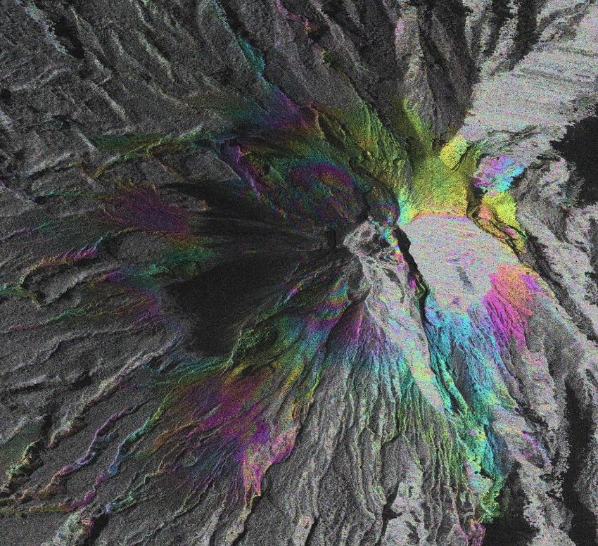
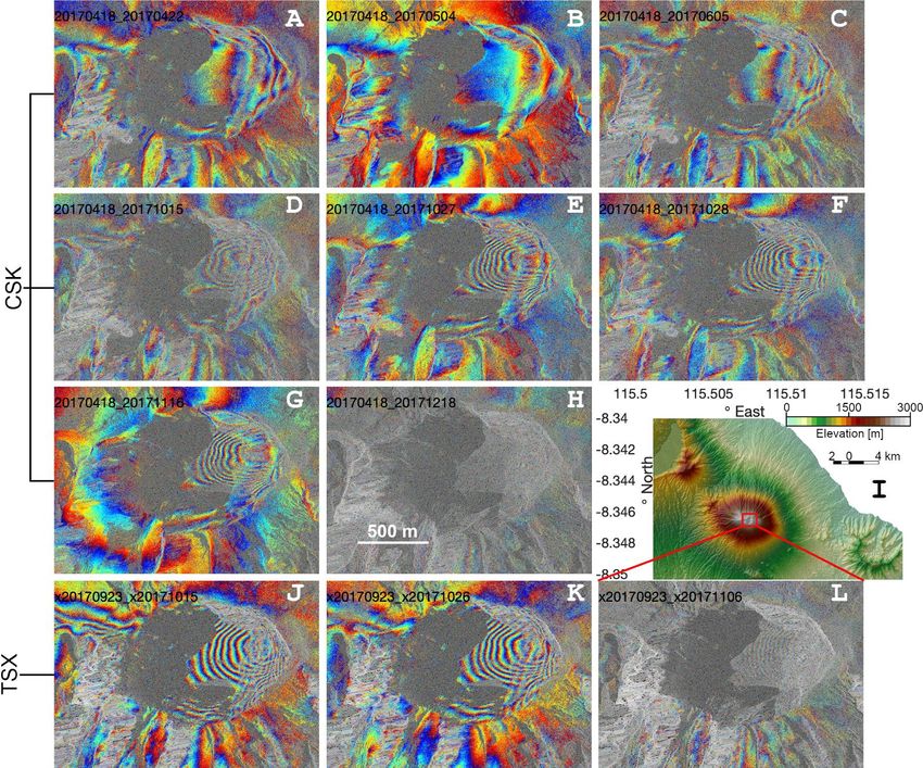
Example: TSX and CSK from Merapi, Indonesia

                                         Merapi, October 5-13, 2020
• Merapi volcano, Indonesia,             CSK spotlight
  showed signs of unrest starting in
  late 2020
• Deformation monitoring consisted
  of one EDM line on the west flank
  of the volcano and several distal
  GNSS sites
• High-resolution X-band data
  proved vital to assessing complex
  deformation patterns that were
  first detected in early October

WGDisasters-15                         • Results shared with CVGHM    slide from Mike Poland, USGS
                                                                                                 5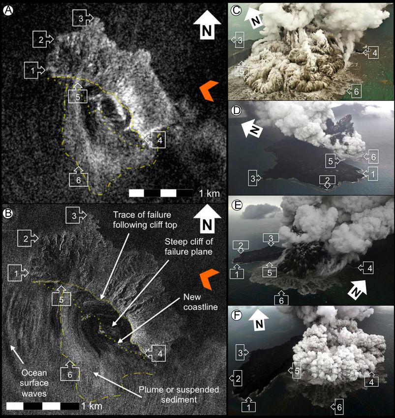
Example: TSX and CSK from Merapi, Indonesia

• Available data included
  “staring spotlight”
  TerraSAR-X data, with
  a pixel size of less than
  1 meter
• Through November
  and December, small-
  scale, rapid
  displacements were
  detected on the west
  flank of the volcano
                              Merapi, November 16-27, 2020
                              TSX staring spotlight
WGDisasters-15                          • Results shared with CVGHM   slide from Mike Poland, USGS
                                                                                                 6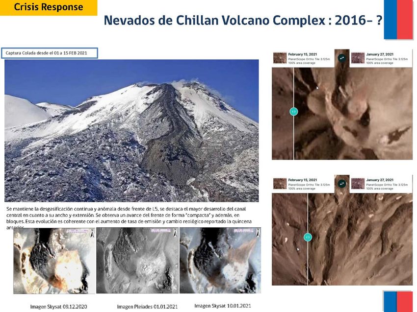
Example: TSX and CSK from Merapi, Indonesia

• The volcano finally began to
  erupt in early January, 2021
• High-resolution X-band satellite
  data confirmed that the rapid
  and localized displacements on
  the volcano’s west flank had
  ceased
• SAOCOM and PAZ imagery
  also provided – combination of
  PAZ and TSX allowed 4 and 7
  day spans (rather than 11)         Merapi, January 25 – February 1, 2021
                                     CSK spotlight
  WGDisasters-15                         • Results shared with CVGHM     slide from Mike Poland, USGS
                                                                                                    7
Example: TSX and CSK from Merapi, Indonesia
Slant range offset Azimuth offset
Cosmo-SkyMed
spotlight (desc)
2020-10-05
2020-11-22
Range: reds = range extension/subsidence
and/or westward
Azimuth: red = displacement in flight direction.
Deformation detection threshold ~0.1*pixel size
• 10 cm CSK spotlight, bit ~2 m Sentinel-1 -> we need high resolution SAR data
Less affected by: large baselines, dense vegetation and/or steep slopes at tropical
stratovolcanoes
WGDisasters-15 Slide from Mark Bemelmans, Bristol 8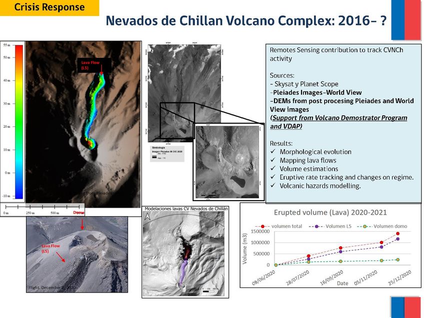
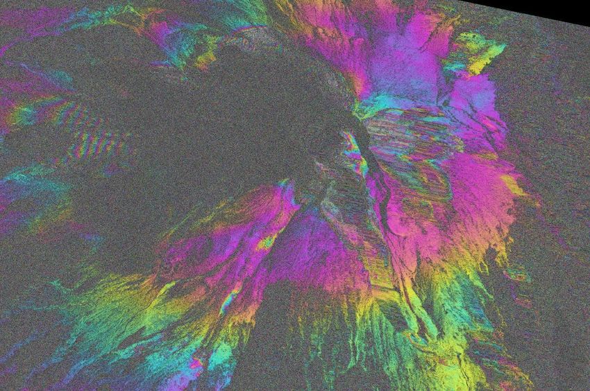
Example: CSK from Sinabung, Indonesia

COSMO-SkyMed
amplitude data from
Sinabung volcano,
Indonesia, have been
used to map changes
in lava dome and flow
activity over time
• Animations shared
with CVGHM

 WGDisasters-15                                            slide from Mike Poland, USGS
                                                                                      9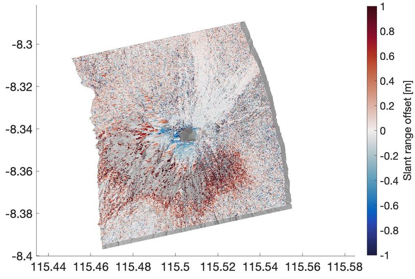
Example: CSK from Sinabung, Indonesia
WGDisasters-15 slide from Mike Poland, USGS
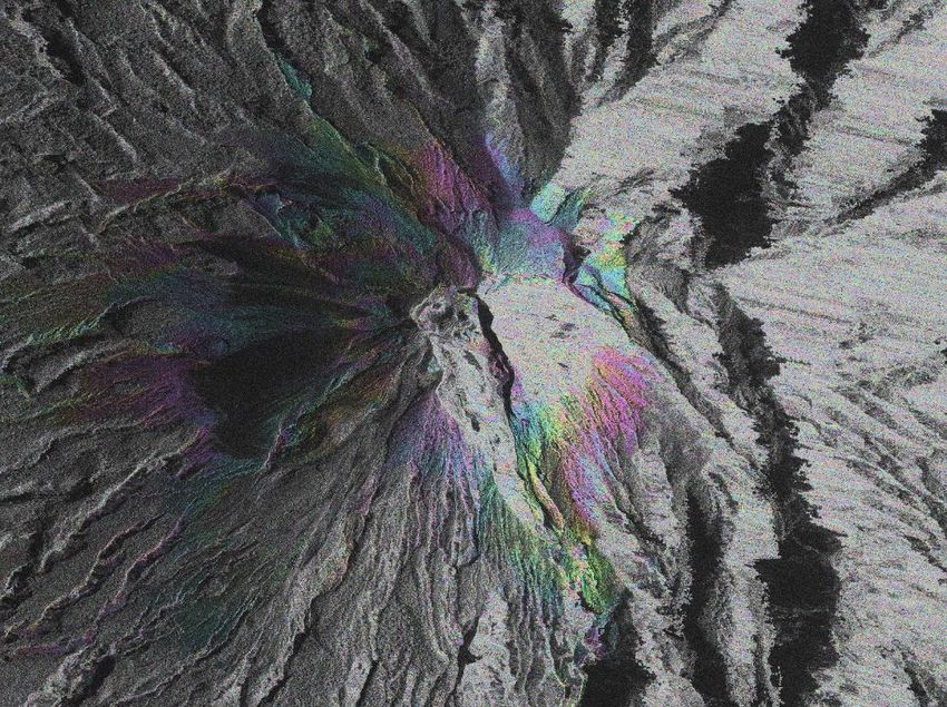
10Example: dome growth at St Vincent
TSX Ascending – TSX Descending -
CSK - 2021/01/17 ICEYE (2021/01/27)
2021/01/24 2021/01/25
Radar geometry
New dome
Incidence Angle: 51° Incidence Angle: 27.5° Incidence Angle: 51° Incidence Angle: 27.6°
5 images 5 images 2 images 1 images
Imagery and results being shared with University of the West Indies and the Seismic Research
Centre (Trinidad & Tobago)Example: dome growth at St Vincent
02/01/202 13/01/202 24/01/202 04/02/202 12/02/202
1 1 1 1 1
N Extracted area
12/02/202 Dome
1 shadow
Geocoded using SRTM
UWISeismic Research areas SAR calculated areas Structures
on dome?
Dome area estimates from TSX asc
1. 02/01/2021 22 368.5 m²
2. 13/01/2021 46 858.8 m²
3. 24/01/2021 67 431.6 m²
4. 04/02/2021 92 742.6 m²
5. 15/02/2021 119 737.0 m²
slide from Edna Dualeh, LeedsTSX ascending track
Example: dome growth at St Vincent
02/01/202 13/01/202 24/01/202 04/02/202 12/02/202
1 1 1 1 1
New
dome
Range Crater Wall
(LOS)
Rough dome height Assumptions in rough height estimations:
(from reduction of crater wall) • Heights are not maxima, but estimations of point of
intercept with crater wall (shown in diagram)
Schematic of dome
Height (m)
interaction and satellite line
of sight (LOS) with example
Crater wall points (red) of dome and wall
Old intersect used to estimate
+ 45 m
+ 50 m
S1 (ascending)
dome
TSX (085) dome growth
Reports (UWISeismic Research Twitter)
slide from Edna Dualeh, LeedsExample: Pleiades in Latin America
• Pleiades imagery provided
through Volcano Demonstrator
used to assess lava flow
volumes at Nevados de
Chillan, Chile
• Comparison to other optical
instruments critical to measure
change
• Pleiades imagery is being used to look at
processes at Sabancaya, Peru
• Tasking also at Nevado del Ruiz,
Colombia
WGDisasters-15 slide from Loreto Cordova, OVDAS, Chile14Example: Pleiades in Latin America
• Contribution to estimations
of volumes and therefore
effusion rate
• Enthusiastic feedback
about CEOS datasets
during March workshop on
satellite and ground-based
volcano monitoring
WGDisasters-15 slide from Loreto Cordova, OVDAS, Chile15Example: further analysis of Agung 2017 event
CSK and TSX analysis adding to earlier
Sentinel work focused on an important
eruption
CSK 2017-11-20 2017-11-28 asc
Reds: range extension/ subsidence and/or
eastward, Blues: range shortening/ uplift and/or
westward
WGDisasters-15 Figures from Mark Bemelmans, Bristol 16Other ongoing work Volcano Monitoring Networks
Satellite based monitoring
• Deformation
• Sangay (CSK), Chiles-Cerro Negro, Cotopaxi (TSX)
– IG-EPN Ecuador
• Pleiades imagery requested for Cayambe (Ecuador)
,Nevado del Ruiz (Colombia), Sabancaya (Peru) and
Nevados
• Regular ‘Baseline’ TSX tasking by Mike:
Chile (7), Ecuador (3), Peru (1), Indonesia (5),
Philippines (4), PNG (5), Vanuatu (3), Caribbean (2).
Volcano Supersite, Geohazard Supersites
and Natural Laboratories (GSNL) of the
Group on Earth Observation (GEO),
Committee of Earth Observation Satellites
(CEOS), Demonstrator Project, COMET,
Leeds University, INGV Italy, OpenSARLab
WGDisasters-15 figure from Silvana Hidalgo, IG-EPN, Ecuador172021 Workshop on volcano monitoring
infrastructure on the ground and in space
Hosted by Matt Pritchard online
(original intention was to be part of
IAVCEI Cities on Volcanoes May 2020)
• 254 registrants from 29 countries
• >20 volcano observatories
represented, as well as researchers
from national agencies and
universities.
Sessions on InSAR, degassing, thermal
- Mike Poland introduced CEOS
Volcano Demonstrator during the
InSAR session.
- Demonstrations of various online tools
for analysis of satellite imagery
WGDisasters-15 18Discussion point: High resolution backscatter
TSX Asc staring spotlight – 2021/02/21 S1 (2021/01/24)
CSK and TSX
spotlight/staring
modes provide
New dome unique data for
eruption response
Radar geometry
– only
instruments with
high enough
resolution to
detect local
changes
important for
hazard
WGDisasters-15 slide from Edna Dualeh, Leeds
19Discussion point: topographic data
• Accurate, recent DEMs are critical for hazard assessment during an eruption:
o Estimation of effusion rate, flow modelling and hazard assessment
articlehasbeen accepted for publication in afutureissueof thisjournal, but hasnot been fully edited. Content may changeprior to final publication. Citation information: DOI 10.1109/JSTARS.2021.3055653, IEEEJournal
o Critical for interpretation of high resolution SAR imagery (e.g., CSK, TSX
JOURNAL OF LATEX CLASS FILES, VOL. 14, NO. 8, AUGUST 2015
of Selected Topicsin Applied Earth Observationsand RemoteSensing
21
especially spotlight modes)
• TanDEM-X is an immensely
powerful tool for volcanology
• Precise, high resolution
measurements of topographic
change, allowing detection of
new lava flows, dome growth
and explosive deposits
WGDisasters-15 Kubanek, Poland & Biggs, 2021 20Discussion point: topographic data
• Accurate, recent DEMs are critical for hazard assessment during an eruption:
o Estimation of effusion rate, flow modelling and hazard assessment
o Critical for interpretation of high resolution SAR imagery (e.g., CSK,
TSX especially spotlight modes)
• 12m WorldDEM
greatly enhances
analysis of high resolution
SAR imagery
• Requested by some
volcano observatories
WGDisasters-15 Pritchard et al., 2018 21Discussion point: L-band imagery
• L-band is critical for InSAR
measurements at densely
vegetated volcanoes, and
where deformation is high
magnitude
Sentinel-1 – ALOS-2
comparison of earthquakes
at Sabancaya, Peru
WGDisasters-15 Figure from Matt Pritchard, Cornell
22Discussion point: constellation imagery
• Volcanic unrest and eruption can progress very quickly – within
hours or days – the sooner images can be acquired the better
• Access to imagery from multiple platforms greatly increases the
likelihood to capturing rapid deformation during unrest or rapid
topographic change during
• Denser time series also provide information about processes that
might otherwise have been missed during retrospective analysis
WGDisasters-15 23Discussion point: constellation imagery
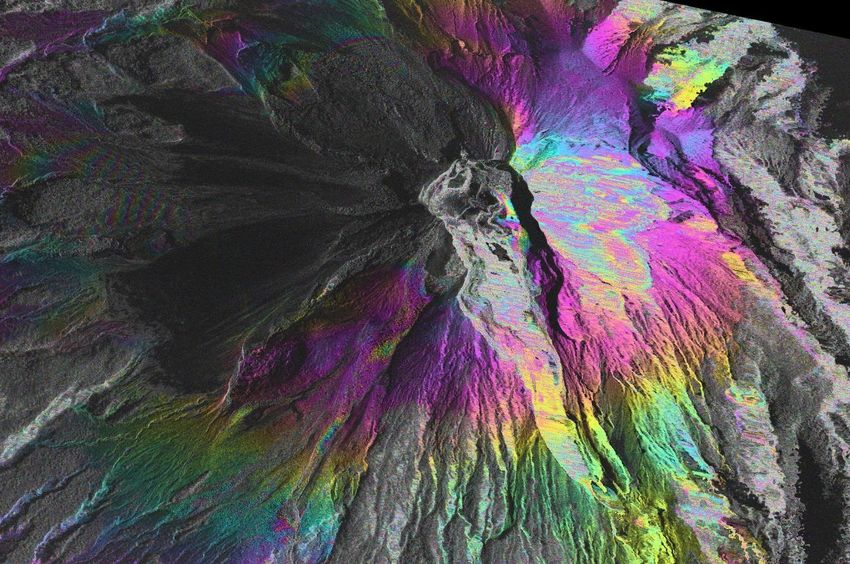
• Collapse of Anak Krakatoa on Dec
22nd 2018, S1 image acquired the
same day
• Higher resolution CSK image (23rd
Dec) allowed improved estimation of
subaerial landslide and facilitated
comparison (Hunt et al., 2021)
=> Use of multiple instruments
allowed retrospective densification of
SAR backscatter time series and
WGDisasters-15
more complete picture of failure event24RSat -2 imagery
• Anticipated requests:
Priority 1:
• Cordon Caulle, Chile (-40.59,-72.12)
Wide Ultra Fine 16 (descending) and Wide Ultra Fine 12
• Is there a quota?
(ascending) with images every 24 days between November 15 and
May 30 (late austral spring to late austral fall).
• Ambae, Vanuatu • Any advice on how much
Extra Fine W2 (descending), and the date range is 2017-07-14 to we need to prioritise from
2018-12-24
CSA would be very
Volcanoes previously approved by CSA: welcome
• Turrialba, Costa Rica (10.02 -83.76)
• Pacaya, Guatemala (14.38 -90.60)
• Santiaguito, Guatemala
• Popocatapetl, Mexico (19.02 -98.62)
• Reventaor, Ecuador (-0.078 -77.66)
• Llaima, Chile (-38.69 -71.73)
WGDisasters-15 25Take home points • Volcano demonstrator is active in tasking TSX, as well providing CSK and Pleiades to volcano observatory scientists and researchers. • High resolution SAR (especially CSK and TSX) has been critical in recent response - volcano observatories are very appreciative of the data • Access to Tandem-X co-SSCs and WorldDEM is incredibly useful for hazard response for many volcanoes – if we could find a way to do this, it would have a big impact • L-band imagery remains the best tool for densely vegetation volcanoes and high magnitude deformation events WGDisasters-15 26
Related publications (last year)

• Albino, F., Biggs, J., Escobar-Wolf, R., Naismith, A., Watson, M., Phillips, J. C., & Marroquin, G. C.
  (2020). Using TanDEM-X to measure pyroclastic flow source location, thickness and volume:
  Application to the 3rd June 2018 eruption of Fuego volcano, Guatemala. Journal of Volcanology
  and Geothermal Research, 406, 107063. (TanDEM-X, Co-SSCs)
• Araya, M. C., & Biggs, J. (2020). Episodic ground deformation associated with geothermal energy
  production at the Guayabo Caldera, Costa Rica. Journal of Volcanology and Geothermal
  Research, 407, 107110. (S1, ALOS-2)
• Hickey, J., Lloyd, R., Biggs, J., Arnold, D., Mothes, P. and Muller, C., 2020. Rapid localized flank
  inflation and implications for potential slope instability at Tungurahua volcano, Ecuador. Earth and
  Planetary Science Letters, 534, p.116104. (S1, CSK)
• Hunt J, Tappin D, Watt S, Susilohadi S, Novellino A, Ebmeier S, Cassidy M, Engwell S, Grilli
  S, Hanif M et al (accepted Feb 2021) Submarine landslide megablocks show half of Anak
  Krakatau island failed on December 22nd, 2018. Nat. Comm. (CSK, TSX, S1)
• Temtime, T., Biggs, J., Lewi, E., & Ayele, A. (2020). Evidence for Active Rhyolitic dike Intrusion in
  the Northern Main Ethiopian Rift from the 2015 Fentale Seismic Swarm. Geochemistry,
  Geophysics, Geosystems, 21(6), e2019GC008550. (CSK, S1)
WGDisasters-15                                                                                             27
You can also read