DRONES IN HYDRAULICS BY HAMISH BIGGS - iAHR
←
→
Page content transcription
If your browser does not render page correctly, please read the page content below
hydrolink 1-2019v3.qxp_25462 22-02-19 13:28 Pagina 4
DRONES IN HYDRAULICS
BY HAMISH BIGGS
The rise of drones in hydraulics reflects the demand for higher resolution data at lower cost. Drones are now
affordable, reliable and easy to use, making them well suited for investigation of finer scale processes (mm to
cm), compared to the landscape scales covered by aircraft and satellites. The rise of drones has also been
paralleled by exponential improvements in lightweight sensor technology. For example, high resolution digital
cameras (>50 MP), LiDAR units and hyperspectral cameras can now be carried by consumer grade drones with
less than 5 kg of payload. This article provides an introduction to the use of drones in hydraulics and discusses
an exciting future of drone based remote sensing.
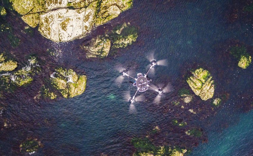
Figure 1. Drones provide a cost-effective platform for aerial surveying of waterbodies. Photograph: Dave Allen, NIWA
Drone hardware imagery and general surveying, while larger aerial imagery is determined by flight speed,
Unmanned Aerial Vehicles (UAVs), Unmanned units (such as the DJI Matrice 600 Pro) are altitude and image overlap. Camera settings,
Aerial Systems (UAS) and Remotely Piloted suitable for LiDAR and other payloads up to 5 flight speed and lighting are critical to obtain
Aircraft Systems (RPAS) are some of the many kg. good aerial imagery. Shutter priority mode is
synonyms for drones. Their forms are equally recommended, with 1/1000 shutter (or faster)
diverse, with fixed wing aircraft, miniature Aerial imagery and surveying to minimise image blur. Ground Control Points
helicopters, balloons, blimps, kites and The most common application for drones in (GCP) are used to obtain georeferenced aerial
multirotor aircraft all used for environmental hydraulics is recording aerial imagery and images. GCPs can be either targets set out
remote sensing [1]. The choice of appropriate surveying (Figure 1). The spatial resolution of and surveyed, or identifiable features with
drone hardware depends on the mission aerial imagery is determined by drone altitude known (surveyed) locations. The use of GCPs
requirements (e.g. area covered, altitude, and camera specifications. For example, the can sometimes be avoided if camera origin is
payload and flight time). The most commonly DJI Phantom 4 Pro with 20 MP sensor and 24 known with RTK or PPK GPS precision. Aerial
used drones for hydraulics applications are mm equivalent focal length lens achieves pixel images can either be analysed individually or
multirotor aircraft. Small multirotors (such as resolution of 5.5 mm at 20 m altitude and 27.5 combined into a ‘georeferenced orthomosaic’
the DJI Phantom 4 Pro) are used for aerial mm at 100 m altitude. The spatial coverage of (basically a 2D photo map) for further analysis
4 hydrolink number 1/2019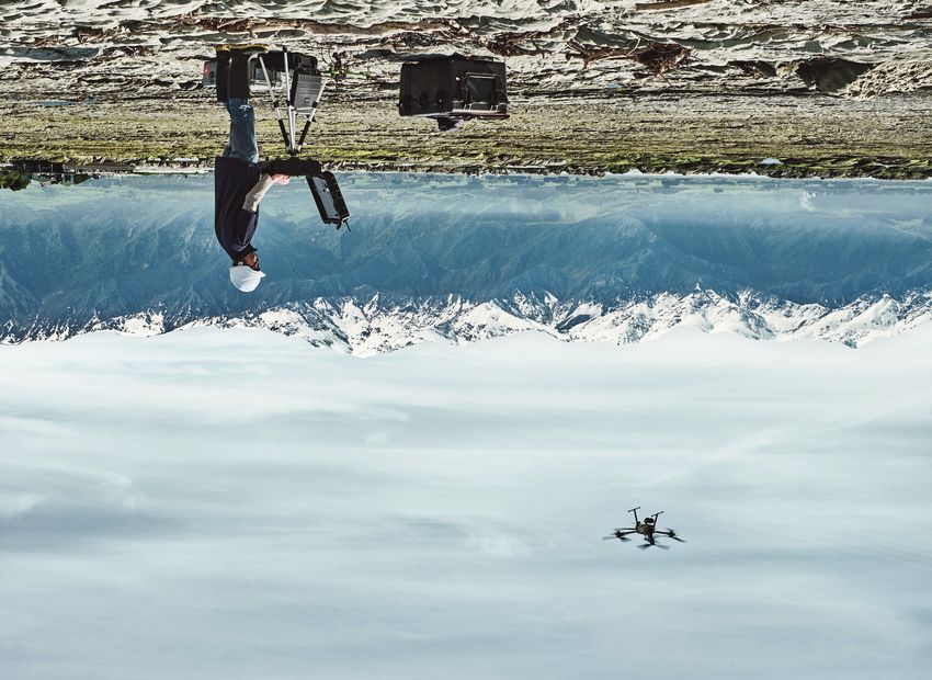
hydrolink 1-2019v3.qxp_25462 22-02-19 13:28 Pagina 5

                                                                                                                                                                          IAHR

                                                              Image analysis                                                           Hamish Biggs is a scientist at
                                                              Classification of aerial imagery can either be                           the National Institute of Water
                                                              performed manually [2] or using automated                                and Atmospheric Research
                                                                                                                                       (NIWA) in New Zealand. His
                                                              techniques [3]. Which approach is appropriate
                                                                                                                                       research covers novel remote
                                                              depends on the survey frequency, input data                              sensing techniques, flow
                                                              type, classes to be resolved and required                                around aquatic vegetation,
                                                              output accuracy. For one-off surveys with RGB                            sediment transport,
                                                              imagery, manual image classification provides        biomechanics, image analysis and field equipment
                                                                                                                   development.
                                                              higher accuracy [3] and is usually faster than
                                                              using automated techniques. For automated
                                                              image classification significant time must be
                                                              spent setting up and tuning the classification      Bathymetry
                                                              algorithms, then evaluating the accuracy of         In the future bathymetric (green) LiDAR units
                                                              the automatic classifications against manual        may reach the price, performance and weight
                                                              classifications or ground truth data. For           of terrestrial (infrared) LiDAR units. When this
                                                              research applications, this is often a diversion    occurs drone-based bathymetric LiDAR
                                                              from the original purpose of the survey and         surveys will become common practice. Until
                                                              results in studies devoted to the accuracy of       then, other means to determine bathymetry
                                                              the automatic classification rather than            from remote sensing data can be used. For
                                                              detailed analysis of the survey data.               example, bathymetry from: underwater
                                                              Automated techniques often struggle to              imagery (Figure 3), through water imagery
                                                              separate the boundaries of overlapping or           corrected for surface refraction [6], spectral
                                                              touching objects within a class. This is not a      attenuation of light with depth, or turbulence
                                                              problem if only the total area of classes is        metrics [7].
                                                              required, however if the dimensions of
                                                              individual objects within a class are required,     Underwater imagery
                                                              then this is a big problem and manual image         The SfM image processing techniques
                                                              classification should be used. Where                typically used for aerial drone surveying, can
         Figure 2. Drone-based survey of aquatic
         vegetation (River Urie, UK)                          automated classification techniques excel is        equally be applied to underwater camera
                                                              for routine monitoring of total class area over     imagery (Figure 3). For rivers that are
                                                              large spatial extents with multispectral or         sufficiently clear and deep, this enables
                                                              hyperspectral imagery [4]. Hyperspectral            Remote Control (RC) boat-based surveys to
                                                              imagery has hundreds of narrow spectral             resolve bathymetry, grain size distributions and
                                                              bands (compared to the 3 lumped bands of            bed roughness. The bathymetry data or solid
                                                              RGB imagery). It is not easy to visualise, but is   models can even be used as inputs for 2D or
                                                              well suited for supervised image classification,    3D hydraulic modelling.
                                                              object-based classification, or machine
                                                              learning approaches [3, 4].                         Sediment size distributions
                                                                                                                  Imagery from drones or underwater cameras
         Figure 3. Solid models of a cobbled river bed        Digital Elevation Models (DEMs)                     (Figure 3) can be used to obtain sediment size
         resolved with underwater imagery from an             Accurate DEMs are critical for many hydraulic       distributions [8, 9]. The smallest size fraction that
         amphibious drone (e.g. RC boat)
                                                              applications (e.g. erosion, hydraulic               these techniques are suitable for depends on
                                                              modelling, sediment transport and                   the spatial resolution of the imagery. For
         (Figure 2). Georeferenced orthomosaics can be        morphodynamics). High resolution DEMs can           braided gravel bed rivers with predominantly
         easily generated with Structure from Motion          be obtained from drone-based aerial imagery         coarse sediment, low altitude drone-based
         (SfM) software such as Agisoft Photoscan or          or light weight terrestrial LiDAR units (such as    surveying is a convenient way to map
         Pix4D. Imagery for this purpose should have          those from LiDAR USA). DEMs from aerial             sediment size distributions over large spatial
         60-80% overlap on all sides and at least 8           imagery are obtained using Structure from           extents. This data has many applications, such
         GCPs distributed throughout the site. Further        Motion (SfM) image processing software (e.g.        as physical habitat mapping, roughness
         analysis of georeferenced orthomosaics often         Agisoft Photoscan or Pix4D). For most terrain       coefficients for hydraulic modelling, or inputs
         entails image segmentation into classes, then        types the DEMs obtained using SfM have              for sediment transport modelling.
         measurement of the total area of classes; or         similar accuracy to LiDAR, but much lower
         measurement of the number, area and dimen-           equipment cost [5]. In terrain that is heavily      Discharge gauging and Large Scale
         sions of objects within a class [2]. Common          vegetated or lacks distinct visual distinct         Particle Image Velocimetry (LSPIV)
         applications in hydraulics are to delineate the      features (e.g. uniform mud, sand, or snow)          Discharge gauging from imagery is useful for
         boundaries of waterbodies, structures and biota      LiDAR provides more accurate and reliable           flow conditions where in-water measurement
         (e.g. vegetation), then evaluate the total surface   data.                                               equipment cannot be deployed (e.g. flash
         area and geometry of objects within each class.                                                          floods and debris flows) or in remote locations

                                                                                                                                        hydrolink      number 1/2019       5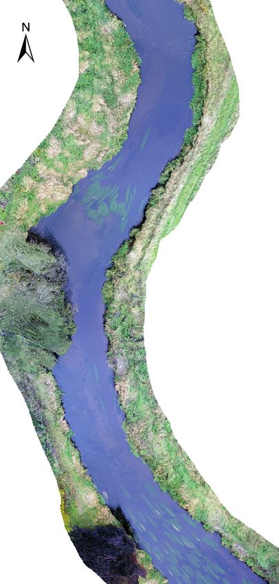
hydrolink 1-2019v3.qxp_25462 22-02-19 13:28 Pagina 6

         without access to standard gauging                 The future?                                         References
                                                                                                                [1]     Klemas, V. (2015). Coastal and environmental remote sensing
         equipment [10]. Imagery can be recorded from       In such a diverse and rapidly evolving field, it           from unmanned aerial vehicles: An overview. Journal of Coastal
                                                                                                                       Research, 31(5), 1260-1267.
         river banks or drones, then LSPIV techniques       is challenging to speculate about the future.       [2]    Biggs, H., Nikora, V., Gibbins, C., Fraser, S., Papadopoulos, K.,
                                                                                                                       Green, D. & Hicks, D.M. (2018). Coupling Unmanned Aerial
         used to determine surface velocities.              However, there are a number of technologies                Vehicle (UAV) and hydraulic surveys to study the geometry and
                                                                                                                       spatial distribution of aquatic macrophytes. Journal of
         Discharge is estimated from surface velocities,    and capabilities to watch. The first is the                Ecohydraulics, 3(1), 45-58.
                                                                                                                [3]    Husson, E., Ecke, F. & Reese, H. (2016). Comparison of manual
         bathymetry and a conversion from surface           performance (and cost) of thermal infrared                 mapping and automated object-based image analysis of non-
                                                                                                                       submerged aquatic vegetation from very-high-resolution UAS
         velocity to depth averaged velocity (such as       cameras. Rapid improvements in both spatial                images. Remote Sensing, 8(9), 724
                                                                                                                [4]    Parsons, M., Bratanov, D., Gaston, K. & Gonzalez, F. (2018).
         the index velocity method). Bathymetry can         resolution (number of pixels) and thermal                  UAVs, Hyperspectral Remote Sensing, and Machine Learning
                                                                                                                       Revolutionizing Reef Monitoring. Sensors, 18(7), 2026.
         be surveyed independently or estimated from        resolution (temperature graduation) will lead to    [5]    Fonstad, M., Dietrich, J., Courville, B., Jensen, J. & Carbonneau,
                                                                                                                       P. (2013). Topographic structure from motion: a new development
         imagery derived data (e.g. turbulence              many exciting applications in hydraulics. For              in photogrammetric measurement. Earth Surface Processes and
                                                                                                                       Landforms, 38(4), 421-430.
         metrics) [7]. Imagery from drones has              example: studying turbulence and mixing             [6]    Dietrich, J. (2017). Bathymetric Structure from Motion: extracting
                                                                                                                       shallow stream bathymetry from multi view stereo photogram-
         advantages over bank-based imagery in              processes at river confluences, identifying                metry. Earth Surface Processes and Landforms, 42(2), 355-364.
                                                                                                                [7]    Detert, M., Johnson, E. & Weitbrecht, V. (2017). Proof of concept
         orthorectification and spatial coverage.           zones of ground water upwelling in rivers,                 for low cost and non contact synoptic airborne river flow
                                                                                                                       measurements. International journal of remote sensing, 38(8-10),
         For example, spatial distributions of surface      studying the breakdown of thermal                          2780-2807.
                                                                                                                [8]    Buscombe, D. (2013). Transferable wavelet method for grain size
         velocities for physical habitat mapping, and       stratification in waterbodies as surface layers            distribution from images of sediment surfaces and thin sections,
                                                                                                                       and other natural granular patterns. Sedimentology, 60(7), 1709-
         discharge gauging in large rivers where bank-      cool, studying mixing processes due to wind                1732.
                                                                                                                [9]    Detert, M. & Weitbrecht, V. (2013). User guide to gravelometric
         based imagery is not feasible. The ‘Drone          loading, using subtle water temperature                    image analysis by BASEGRAIN. In: Advances in River Sediment
                                                                                                                       Research, Proceedings of the 12th International Symposium on
         flow’ project in New Zealand is currently          differences as tracers for LSPIV, and discharge            River Sedimentation ISRS 2013, (pp. 1789-1796). Kyoto, Japan.
                                                                                                                       CRC Press.
         developing a drone based LSPIV system              gauging at river confluences. The development       [10]   Le Coz, J., Jodeau, M., Hauet, A., Marchand, B. & Le
                                                                                                                       Boursicaud, R. (2014). Image-based velocity and discharge
         featuring a stereoscopic camera system, high       of high performance aerial surveying systems               measurements in field and laboratory river engineering studies
                                                                                                                       using the free Fudaa-LSPIV software. In: Proceedings of the inter-
         resolution IMU (for camera orientation) and        (such as ‘Drone flow’) also promise an exciting            national conference on fluvial hydraulics, River Flow 2014 (pp.
                                                                                                                       1961–1967). Lausanne, Switzerland. CRC Press.
         RTK GPS (for camera origin) that will avoid the    future for drones in hydraulics by providing
         need for Ground Control Points (GCPs) and          input data for hydraulic modeling, fish
         significantly improve drone based hydraulic        passage, discharge gauging and physical
         measurements.                                      habitat assessments. n

         Figure 4. Dr David Plew commences a surveying mission in Kaikoura, New Zealand. Photograph: Jochen Bind, NIWA

   6     hydrolink   number 1/2019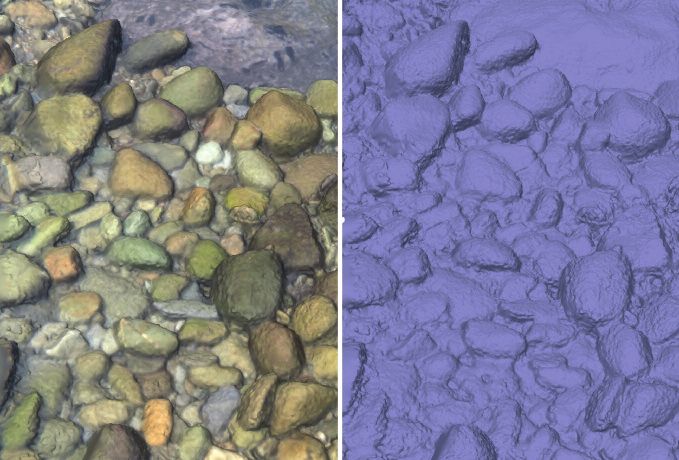
You can also read