Wildland Fire Protection Plan 2020-2022 Dixie Power July 1, 2020
←
→
Page content transcription
If your browser does not render page correctly, please read the page content below
Wildland Fire Protection Plan 2020-2022
              Dixie Power
              July 1, 2020

                   1
Table of Contents
Introduction to Dixie Power ........................................................................................................................ 3
   a. Description of areas within the service territory of the electric cooperative that may be subject to
      a heightened risk of wildland fire ....................................................................................................... 4
      Escalante Valley (Beryl) Area Substations and Feeders .............................................................. 6

         Dixie and Arizona Area Substations and Feeders ....................................................................... 8

   b. Description of the procedures, standards, and time frames that the electric cooperative will use to
      inspect and operate its infrastructure.............................................................................................. 15
   c. Description of the procedures and standards that the electric cooperative will use to perform
      vegetation management .................................................................................................................. 16
   d. Description of proposed modifications or upgrades to facilities and preventative programs that
      the electric cooperative will implement to reduce the risk of its electric facilities initiating a
      wildland fire ...................................................................................................................................... 18
   e. Description of procedures for de-energizing power lines and disabling reclosers to mitigate
      potential wildland fires, taking into consideration .......................................................................... 20
   f.    Description of the procedures the electric cooperative intends to use to restore its electrical
         system in the event of a wildland fire .............................................................................................. 21
   g. Description of potential consultation, if applicable, with state or local wildland fire protection
      plans ................................................................................................................................................. 22
   h. Consider input from.......................................................................................................................... 23
   i.    Third Party review ............................................................................................................................ 24
   j.    Date of meeting and board approval ............................................................................................... 24
Appendix A: Glossary for Dixie Power ....................................................................................................... 25
Appendix B: Maps of Dixie Power Territory .............................................................................................. 27
Appendix C: Maps of Dixie Powerlines relative to Fire Threat Index Areas ............................................ 28
Appendix D: Maps of Dixie Powerlines relative to Fire Risk Index Areas ............................................... 29
Appendix E: Inspection Rubrics for RESAP ................................................................................................ 30
Appendix F: Right of Way and Vegetation Management Standards ........................................................ 31
Appendix G: Wildland Fire Prevention/Response Procedure .................................................................. 35
Appendix H: Revision Tracking .................................................................................................................. 37

                                                                              2
Wildland Fire Protection Plan 2020-2023
                                                Dixie Power
                                                July 1, 2020

Dixie Power is a non-profit rural electric cooperative, originally established under the United States
Department of Agriculture (USDA) Rural Electrification Act (REA) in 1946, and currently serves
approximately 25,000 customers in the southwest corner of Utah, in Washington and Iron counties, and
the northwest corner of Arizona, in Mohave county.

Dixie Power is headquartered in Beryl, Utah, with additional offices in Bloomington and Bloomington
Hills in St. George, Utah, and in Beaver Dam, Arizona.

The management team of Dixie Power consists of:

        LaDel Laub, Chief Executive Officer, ladell@dixiepower.com
        Colin Jack, PE, Chief Operating Officer, colinj@dixiepower.com
        Chery Hulet, Chief Financial Officer, cheryh@dixiepower.com

The official mailing address of the cooperative is:

        71 East Highway 56
        Beryl, Utah 84714

The phone number for any or all of the offices is: 435-439-5311

Dixie Power serves suburban and rural residential, agricultural, commercial, and light industrial
customers in the communities of Newcastle, Modena, Pine Valley, St George, Washington, Hurricane,
Beaver Dam, and Scenic. See Map 1, Land Ownership, in Appendix B. To serve these customers Dixie
Power has:

 County, State      Customers        Acres         Miles of     Substations   Miles of OH    Miles of UG
                                                transmission                  distribution   Distribution
      Iron, UT              880      759,839               33             7            228             32
Washington, UT           20,622      235,310              117            19            154            506
   Mohave, AZ             2,699      272,477               24             2            109             25
       TOTALS            24,201    1,267,626              174            28            491            563

The Mission Statement of Dixie Power is:

        “Building Trust by equitably serving our members and communities with safe, reliable,
        affordable energy.”

Everything Dixie Power does is to meet the mission detailed in that statement.

                                                      3
“Success depends upon previous preparation, and without such preparation there is
        sure to be failure.” Confucius

The purpose of the analysis and practices detailed in this Wildland Fire Protection Plan is to:

        1. Protect the public.
        2. Minimize the chance of the cooperative’s powerlines starting wildfires.
        3. Speed the recovery from any wildfires that may occur.

The plan contained in the following document has been drafted to comply with the requirements
specified in Utah Code 54-24-203 and has been reviewed by the pertinent agencies, with input from all
interested parties, has been reviewed by a third party expert, and duly adopted by the Board of
Directors of Dixie Power, all of which has been documented in the body of the plan. A Glossary of Terms,
specific to this industry and used throughout this plan is included in Appendix A.

Parts (a) through (h) [in bold, following] are the specific items covered in this Wildland Fire Protection
Plan and have been extracted directly from the text of Utah Code 54-24-203. The paragraphs following
each point have been drafted to address each of the requirements of the legislation.

All sections in this plan will be regularly updated and modified as needed, depending on experience. As a
minimum, this plan will be reviewed annually and the findings presented to the cooperative’s Board of
Directors (Governing Authority,) and updated every three years with new assessments and to
incorporate new technology and current best practices.

(a) Description of areas within the service territory of the electric cooperative that may be subject to
    a heightened risk of wildland fire;

    Dixie Power has had a direct experience with wildfire, back in June 2017, when the “North Fire” of
    unknown origin burned down a one-mile segment of Dixie Power’s overhead (OH) distribution line
    between the communities of Newcastle and Pine Valley; no dwellings or lives were lost in the
    wildfire, but electrical service was lost to the community of Pine Valley for thirty hours. Based on
    this experience, Dixie Power considers the line between Newcastle and Pine Valley to be of high risk.
    Since the occurrence of the North Fire, Dixie Power has completely replaced eight miles of OH line,
    the oldest section of the line, with the worst access, and which was completely closed off to the
    cooperative crews for the entire decade preceding the fire, of the approximately 25-mile overhead
    line, with new poles, crossarms, insulators, and wire, and shortened up the span lengths and opened
    up better access, all of which should reduce the risk of future wildfires on that line.

    In addition to this one OH powerline in which Dixie Power experienced the direct effects of a
    wildfire, the cooperative has evaluated each of its powerlines (feeders) relative to the risk of starting
    a wildland fire. This analysis process started with overlaying the cooperative’s Geographical
    Information System (GIS,) which maps all the powerlines owned and operated by the cooperative,
    over the Fire Threat Index and Fire Risk Index GIS maintained by the Utah Division of Natural
    Resources (DNR) in their Utah Wildfire Risk Assessment Portal, UWRAP, (see:
    https://wildfirerisk.utah.gov/.)

                                                     4
Note: The “Fire Threat” includes fuels, vegetation, terrain, and available fire suppression; UWRAP
defines: “Wildfire Threat is a number that is closely related to the likelihood of an acre burning and
is displayed in the Utah WRA by the Fire Threat Index. The Fire Threat Index combines the
probability of an acre igniting (Fire Occurrence Density), the expected final fire size based on rate of
spread in four weather percentile categories and the effectiveness of fire suppression resources.
Since all areas in Utah have Fire Threat Index (FTI) calculated consistently, it allows for comparison
and ordination of areas across the entire state. For example, a high threat area in Eastern Utah is
equivalent to a high threat area in Western Utah.” “Fire Risk” aggregates the Threat with the effects,
or monetary values associated with the fires (homes, structures, etc.); UWRAP defines: “Wildfire
Risk represents the possibility of loss or harm occurring from a wildfire and is displayed in the Utah
WRA by the Fire Risk Index. Wildfire Risk combines the likelihood of a fire occurring (Threat), with
those areas of most concern that are adversely impacted by fire (Fire Effects), to derive a single
overall measure called the Wildfire Risk Index. It identifies areas with the greatest potential impacts
from a wildfire considering the likelihood of an area burning and the impacts to values and assets
aggregated together. Since all areas in Utah have the Wildfire Risk Index calculated consistently, it
allows for comparison and ordination of areas across the entire state.”

The resulting composite maps for all the powerlines owned and operated by Dixie Power are found
in Appendix C (Fire Threat Index Areas) and Appendix D (Fire Risk Index Areas.) The overhead
powerlines are drawn in blue in the composite maps and the underground powerlines are drawn in
green. The areas of high fire threat index and high fire risk index are colored in red and orange, so
the areas of interest are where the blue lines cross the orange and red areas. The overhead lines are
a greater potential threat in a wildfire situation than underground lines because bare overhead
wires are largely supported in open air on wooden poles and could be exposed to fire and lightning;
underground lines are practically uninvolved in a wildfire situation because they’re buried four feet
under the surface level of the ground.

In reviewing other wildfire information found in the UWRAP portal, there is information on the Land
Ownership or Management, Surface Fuels/Vegetation, as well as the Historical Fire Occurrence
Density. Those three maps are shown in the Appendix B. On the first of those three maps, it can be
seen that the preponderance of the area in the Dixie Power service territory is BLM (yellow,) U.S.
Forest Service (green,) Utah State Trust Lands (blue,) with some private (white;) most of the
powerlines are actually located in the white (private land) area. On the second of those three maps,
the Surface Fuels, it can be seen that preponderance of surface fuels in the Dixie Power territory
are: short, sparse, dry climate grass, i.e. exotic herbs (pink area;) moderate load, dry climate grass-
shrub, i.e. Desert Scrub/Steppe (yellow area;) and some high load, humid climate grass-shrub, i.e.
Pinyon-Juniper (orange area.) In the third of those three maps, the Historical Fire Occurrence
Density, it can be seen that the majority of the fires in Washington and Iron counties have been
located around the urban and suburban areas of Washington County and up the I-15 corridor and
around the town of Pine Valley. For this very reason, the first two projects specified in this plan are
around and in the town of Pine Valley.

Using the composite GIS, each of the Dixie Power feeders were individually analyzed for risk of
wildfire; the results of the analysis are displayed in the tables below. In the first column on the left is
the name and map location of the substation. The second column gives the feeder number and the
third column contains a description of the feeder, including a map reference number; each feeder
starts at the substation and then extends out to the end of the line. The fourth column contains the
                                                   5
description of the fire risk analysis for that feeder, including map reference numbers, and addresses
  fire risk levels as well as any projects required to reduce the threat of powerline-caused wildfires.

                         Escalante Valley (Beryl) Area Substations and Feeders
Substation    Feeder         Description                                      Analysis
Austin Sub     181     OH South To Hwy 56        This feeder serves mostly irrigated, cultivated land
(Beryl Area            (Beryl Area Map B5        (marked in green on the maps) and so poses very
 Map B5)               and B2)                   negligible fire risk. The one area of concern includes
                                                 the two segments on the southwest portion of this
                                                 feeder where the OH line leaves irrigated land, near
                                                 Highway 56 (see map B5 & B2.) The first 5.2-mile
                                                 segment (181-1) of three-phase line has old poles and
                                                 old conductor and so is scheduled for replacement in
                                                 2025. The second segment (181-2) is approximately 2
                                                 miles long with some three and single-phase line with
                                                 old poles and conductor and is scheduled to be
                                                 replaced in 2026.
               182     OH West to Modena         This feeder crosses a lot of area with red and orange
                       (Beryl Area Map B5,       risk level and so requires a fair amount of detailed
                       B2, and B1)               evaluation. The first segment of this feeder, going
                                                 west, (map B5) has good, new poles with good ACSR
                                                 conductor. Continuing west on this feeder (map B2)
                                                 there are segments with old poles and old conductor
                                                 that are slated for rebuild on the dates indicated in the
                                                 following list for each segment:
                                                  - 182-1: 3.5 miles in 2032
                                                  - 182-2: 4.1 miles in 2031
                                                  - 182-3: 1.75 miles in 2027
                                                  - 182-4: 3 miles in 2028
                                                  - 182-5: 8.1 miles in 2030
                                                  - 182-6: 13.3 miles in 2029
                                                 Continuing south west past the town of Modena (map
                                                 B1) there is a segment of line that is new, with new
                                                 poles and conductor (2015) and so is considered to be
                                                 of low threat for starting a wildfire.
               183     OH North                  This feeder serves mostly irrigated, cultivated land
                       (Beryl Area Map B5,       (marked in green on the maps) and so poses very
                       B3, and B4)               negligible fire risk.
               184     OH East                   This feeder serves mostly irrigated, cultivated land
                       (Beryl Area Map B5)       (marked in green on the maps) and so poses very
                                                 negligible fire risk.
 Bar V Sub     131     OH West                   This feeder serves mostly irrigated, cultivated land
(Beryl Area            (Beryl Area Map B7        (marked in green on the maps) and so poses very
 Map B7)               and B5)                   negligible fire risk. At the very southern end of the
                                                 feeder (map B7) it enters a red zone, where the line
                                                 has new poles and conductor and so poses very little

                                                  6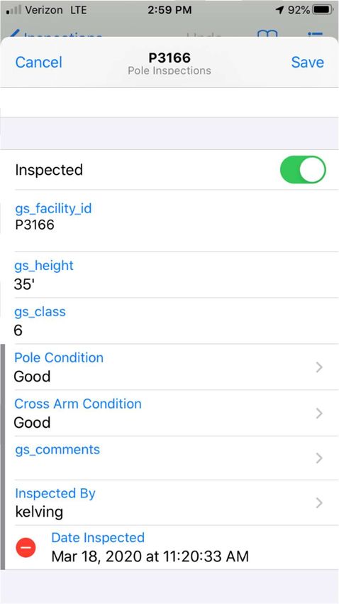
wildland fire risk. And, at the north western edge of
                                             the feeder, along Highway 56, (map B5) it crosses a
                                             red zone, and since this 6-mile segment (131-1) has
                                             old poles and old conductor it is scheduled to be
                                             replaced in 2024.
              132   Underbuild North to      This feeder serves mostly irrigated, cultivated land
                    Hwy 56                   (marked in green on the maps) and so poses very
                    (Beryl Area Map B7       negligible fire risk.
                    and B5)
              134   UG East                  Entirely underground feeder
                    (Beryl Area Map B7)
Bowler Sub    162   34.5kV South to Mine     This 2-mile 34.5kV transmission line (segment 162-1)
(Beryl Area         Sub                      goes south to the Mine Sub (map B5,) crosses an
 Map B5)            (Beryl Area Map B5)      orange zone, has old poles and is scheduled for
                                             replacement in 2034.
              163   34.5kV North to Austin   This 34.5kV transmission line goes north to the Austin
                    Sub                      Sub, crosses mostly irrigated, cultivated land (marked
                    (Beryl Area Map B5)      in green on the maps) and so poses very negligible fire
                                             risk.
Crossroads    142   OH East Hwy 56           This feeder partly serves irrigated, cultivated land
   Sub              (Beryl Area Map B5)      (marked in green on the maps) which poses very
(Beryl Area                                  negligible fire risk.
 Map B5)      143   OH West Hwy 56           This feeder serves mostly irrigated, cultivated land
                    (Beryl Area Map B5)      (marked in green on the maps) and so poses very
                                             negligible fire risk. The far western segment of this
                                             feeder (map B5) that enters an orange zone is new
                                             (2003,) with new poles and wire, and so poses very
                                             negligible risk of starting a wildfire.
              144   OH North Hwy 18          This feeder serves mostly irrigated, cultivated land
                    (Beryl Area Map B5)      (marked in green on the maps) and so poses very
                                             negligible fire risk.
 Mine Sub     201   OH West                  This feeder serves completely cleared ground around
(Beryl Area         (Beryl Area Map B5)      the old defunct silver mine, which is colored in white
 Map B5)                                     on the map, and so poses very negligible fire risk.
Moyle Sub     110   138kV to Moyle SW        Entirely contained within sub site
(Beryl Area   111   unused                   unused
 Map B6)      112   34.5kV to Crossroads     This 34.5kV transmission line passes through irrigated,
                    Sub                      cultivated land (marked in green on the maps) which
                    (Beryl Area Map B6       poses very negligible fire risk. However, in the middle
                    and B5)                  of the line (segment 112-1) it crosses a red zone, and
                                             since this 6.1-mile line segment has old poles and
                                             conductor it is scheduled to be replaced in 2033.
              113   34.5kV to Pinto/Pine     This 34.5kV feeder crosses red and orange zones but
                    Valley                   has new poles and wire, except for a short 2.4-mile
                    (Beryl Area Map B6       segment, the Reber and Ence taps to the east, which
                    and B8)                  includes two short pieces (segment 113-1 on map B8)
                                             7
both of which have old poles and wire and so are
                                              scheduled to be replaced in 2023.
               114     34.5 kV To Newcastle   This 34.5kV transmission line passes entirely within
                       (Beryl Area Map B6)    the cleared ground inside the town of Newcastle,
                                              which is colored in white on the map, and so poses
                                              very negligible fire risk.
 Moyle SW      101     138kV to Bowler Sub    This 138kV transmission line passes through irrigated,
(Beryl Area            (Beryl Area Map B6     cultivated land (marked in green on the maps) which
 Map B6)               and B5)                poses very negligible fire risk. However, in the middle
                                              of the line it crosses a red zone, but since this line has
                                              newer poles and conductor it poses negligible fire risk.
New Castle     123     3Ø OH Newcastle        The first and last segments of this feeder cross mostly
   Sub                 North                  irrigated, cultivated land (marked in green on the
(Beryl Area            (Beryl Area Map B6)    maps) and so poses very negligible fire risk. However,
 Map B6)                                      there is a middle 7.1-mile segment (123-1) of this
                                              feeder (map B6) that crosses an orange zone and
                                              which has old poles and wire and so is scheduled to be
                                              replaced in 2032.
               124     OH Newcastle West -    This feeder serves mostly irrigated, cultivated land
                       Hwy 56                 (marked in green on the maps) and so poses very
                       (Beryl Area Map B6)    negligible fire risk.
               125     OH Newcastle East      This feeder does not leave the substation. It is a
                       (Beryl Area Map B6)    backup to feeder 124.
Pine Valley    321     OH South/Pine Valley   This feeder lies entirely within the town of Pine Valley
   Sub                 Town                   (map B9) and so poses little risk of wildfire even
(Beryl Area            (Beryl Area Map B9)    though it is colored in red. Even so, the 3.1-mile
 Map B9)                                      segment (321-1) at the far east side of town has old
                                              poles which are scheduled to be replaced in 2021.
   Pinto       301     South to Pine Valley   This feeder crosses red and orange zones but has new
(Beryl Area            (Beryl Area Map B8     poles and wire, except for a short 2.2-mile segment
 Map B8)               and B9)                (301-1,) at the end of the Grass Valley tap to the east
                                              (map B9,) which has old poles and wire and so is
                                              scheduled to be replaced in 2022.

                          Dixie and Arizona Area Substations and Feeders
Substation    Feeder         Description                               Analysis
 Atkinville    631     Transmission             New large (397MCM) ACSR conductor supported on
Substation             underbuild North &       steel transmission poles, underbuilding the
(Dixie Area            South (map D3)           transmission line.
 Map D3)       632     UG to Desert Color       Entirely underground feeder (map D3)
               633     UG to Auburn Hills       Entirely underground feeder (map D3)
              63 Bus   63T1 Bus (15kV)          Entirely contained within sub site
                1
               63T1    63T1 Breaker (69kV)    Entirely contained within sub site
Atkinville     621     69kV To Beaver Dam     New (2011) transmission line with large (1272MCM)
                                               8
Switch Yard Substation ACSR conductor supported on composite fiber and
(Dixie Area (maps D3, D2, and D1) resin poles and transmission insulators.
Map D3)
Beaver Dam 721 OH Underbuild to Relatively new ACSR conductor supported on wood
Sub Littlefield transmission poles, underbuilding the transmission
(in AZ) line.
722 OH to Desert Springs Relatively new OH distribution line in the State of AZ
with wood poles and ACSR conductor.
723 OH to Beaver Dam Relatively new OH distribution line in the State of AZ
with wood poles and ACSR conductor.
724 UG North to Pioneer Rd Entirely underground feeder
Bloomington 541 OH East 2800 South New large (397MCM) ACSR conductor supported on
Hills Sub steel transmission poles, underbuilding the
(Dixie Area transmission line. Normally open emergency
Map D3) backfeed.
542 OH West River Road New large (397MCM) ACSR conductor supported on
steel transmission poles, underbuilding the
transmission line.
543 UG to Hills South Entirely underground feeder
544 UG to Hills North Entirely underground feeder
545 UG to Hills North Entirely underground feeder
546 UG to Hills South Entirely underground feeder
547 UG Tie line to Lytle Sub Entirely underground feeder. Normally open
emergency backfeed.
Bloomington 561 OH South to South New large (397MCM) ACSR conductor supported on
Sub Bloomington wood transmission poles, underbuilding the
(Dixie Area transmission line.
Map D3) 562 UG to Man o’ War Rd Entirely underground feeder
564 Underbuild to River New large (397MCM) ACSR conductor supported on
Road steel transmission poles, underbuilding the
transmission line.
566 OH North to Wal-Mart New large (397MCM) ACSR conductor supported on
relatively new wood poles. There is one OH line
segment that passes through a red zone as it crosses
the Virgin River (see Dixie High Threat map 1) and that
is also with large ACSR conductor and relatively new
poles (1987.)
Bloomington 561-1 Port of Entry Recloser Relatively new OH distribution line in the State of AZ
Sub Line with wood poles and ACSR conductor.
(Dixie Area 561-2 Gypsum Mine Recloser New OH distribution line in the State of AZ with wood
map D3) (Feeds Seegmiller Mtn) poles and ACSR conductor.
Church Farm 505 69kV to Quail Creek The first half of this line, starting at the substation
Sub Hydro (map D3,) is a new transmission line with large
(Dixie Area (Dixie Area map D3 and (795MCM) ACSR conductor supported on steel
Map D3) D4.) transmission poles and transmission insulators. The
second half of this transmission line, ending at the
9Quail Creek Hydro (map D4,) in Hurricane, is older
(mid-1980’s,) with wood poles and 4/0 AWG ACSR and
will be replaced in 2021.
571 South on 3000 (1450 This feeder serves mostly irrigated, landscaped
South Backup) property (marked in white on the maps) and so poses
very negligible fire risk.
572 North Along 3000 East, This feeder serves mostly irrigated, landscaped
West Side of Rd. property (marked in white on the maps) and so poses
very negligible fire risk.
573 OH East on 1140 South This feeder serves mostly irrigated, landscaped
property (marked in white on the maps) and so poses
very negligible fire risk.
574 1450 South Underbuild This feeder serves mostly irrigated, landscaped
Stone Cliff/River property (marked in white on the maps) and so poses
Hollow very negligible fire risk.
575 North to Pine View This feeder serves mostly irrigated, landscaped
Estates property (marked in white on the maps) and so poses
very negligible fire risk.
576 UG East on 1140 South Entirely underground feeder
Church Farm 501- 138kV Millcreek New transmission line with large (1272MCM) ACSR
Sw. Yard 502 Generation conductor supported on steel transmission poles and
(Dixie Area transmission insulators. There is one segment that
Map D3) passes through a red zone as it crosses the Virgin
River (see Dixie High Threat map 3) and that is also
with large ACSR conductor and steel poles (2005) and
so poses negligible fire risk.
501- 138kV St George Sub New transmission line with large (795MCM) ACSR
503 conductor supported on steel transmission poles and
transmission insulators. There are two segments that
pass through orange/red zones, as it crosses the
Desert Tortoise Reserve and then the Virgin River (see
Dixie High Threat map 3) and those are also with large
ACSR conductor and steel poles (2002) and so poses
negligible fire risk.
502- 138kV Fort Pierce Sub New (2002) transmission line with large (795MCM)
503 ACSR conductor supported on steel transmission
poles and transmission insulators crosses only green
and white areas on the map and so poses negligible
fire risk.
Dixie Springs 511 OH West This feeder has a mix of overhead OH and UG
Sub distribution lines serving largely irrigated landscaped
(Dixie Area or irrigated cultivated rural areas inside the City of
Map D4) Hurricane and around the Sand Hollow Reservoir. The
wildfire risk levels are determined to be relatively low,
colored from green to tan.
512 OH East This feeder has a mix of overhead OH and UG
10distribution lines serving largely irrigated landscaped
or irrigated cultivated rural areas inside the City of
Hurricane and around the Sand Hollow Reservoir. The
wildfire risk levels are determined to be relatively low,
colored from green to tan.
513 UG to SH Pump Station Entirely underground feeder that never leaves the
fenced area.
514 OH South to Dixie This feeder is almost entirely underground and feeds
Springs the irrigated, landscaped subdivision of Dixie Springs
and so poses a negligible risk of wildfire.
Fort Pierce 551 OH North River Road New large (397MCM) ACSR conductor supported on
Sub Underbuild steel transmission poles, underbuilding the
(Dixie Area transmission line, and so poses negligible fire risk.
Map D3) 552 Commerce/N. River Rd This is a relatively new OH feeder with wood poles
& 3850 S. and ACSR conductor that serves in an industrial park
where the properties are either cleared of vegetation
or landscaped and so there is a low risk of wildfire.
553 OH East to Armory This is a relatively new OH feeder mostly underbuilt
on the steel poles of the transmission line and with
large ACSR conductor that serves in an industrial park
where the properties are either cleared of vegetation
or landscaped and so there is a low risk of wildfire.
554 West Enterprise Dr. This is a relatively new OH feeder with wood poles
and ACSR conductor that serves in an industrial park
where the properties are either cleared of vegetation
or landscaped and so there is a low risk of wildfire.
555 UG East to Old Entirely underground feeder
Dominion
556 OH South River Road New large (397MCM) ACSR conductor supported on
steel transmission poles, underbuilding the
transmission line and so poses negligible fire risk.
555-1 OH To Airport This is a relatively new OH distribution line with wood
poles and ACSR conductor that was built in recent
years to serve the new airport and crosses terrain
colored yellow on the threat map so it poses little
wildfire risk.
69-551 69kV River Road East to New transmission line with large (795MCM) ACSR
Breaker 505 conductor supported on steel transmission poles and
transmission insulators and so poses negligible fire
risk.
69-552 69kV River Road West New transmission line with large (795MCM) ACSR
to Bloomington conductor supported on steel transmission poles and
transmission insulators and so poses negligible fire
risk.
69-553 New transmission line with large (795MCM) ACSR
conductor supported on steel transmission poles and
11transmission insulators and so poses negligible fire
risk.
69-554 69kV East to WB & DS New transmission line with large (795MCM) ACSR
Subs conductor supported on steel transmission poles and
transmission insulators and so poses negligible fire
risk.
69-BT 69kV Bus Tie Breaker Entirely contained within sub site
69-CS3 69kV CS3 Cap Bank Entirely contained within sub site
69-CS4 69kV CS4 Cap Bank Entirely contained within sub site
69-CS5 55T4 20 MVA Entirely contained within sub site
Transformer
69-CS6 55T3 20 MVA Entirely contained within sub site
Transformer
Hughes 703-1 Las Vegas Way South Relatively new OH distribution line in the State of AZ
Bench Line with wood poles and ACSR conductor.
(in AZ) 703-2 Las Vegas Way West Relatively new OH distribution line in the State of AZ
with wood poles and ACSR conductor.
Hughes 701 OH to Desert Skies RV Relatively new OH distribution line in the State of AZ
Bench Sub with wood poles and ACSR conductor.
(in AZ) 703 OH to Scenic Relatively new OH distribution line in the State of AZ
with wood poles and ACSR conductor.
704 OH to Hughes Bench Relatively new OH distribution line in the State of AZ
with wood poles and ACSR conductor.
Lytle 641 UG North to St James Entirely underground feeder
Substation 642 UG North to Pintura Entirely underground feeder
(Dixie Area 643 UG East to 2800 South Entirely underground feeder
Map D3) 644 UG North to Condos Entirely underground feeder
64 Bus 64T1 Bus (15kV) Entirely contained within sub site
1
64T1 64T1 Breaker (69kV) New transmission line with large (795MCM) ACSR
conductor supported on steel transmission poles and
transmission insulators and so poses negligible fire
risk.
Majestic 6005 60T1 Breaker (69 kV) New transmission line with large (1272MCM) ACSR
View Sub conductor supported on steel transmission poles and
(Dixie Area transmission insulators and so poses negligible fire
Map D3) risk.
6006 60T2 Breaker (69 kV) New transmission line with large (1272MCM) ACSR
conductor supported on steel transmission poles and
transmission insulators and so poses negligible fire
risk.
6009 Majestic View 69 kV Entirely contained within sub site
Bus
6010 Church Farm 69 kV Line New transmission line with large (1272MCM) ACSR
conductor supported on steel transmission poles and
transmission insulators and so poses negligible fire
12risk.
6011 Dixie Springs 69 kV Line New transmission line with large (1272MCM) ACSR
conductor supported on steel transmission poles and
transmission insulators and so poses negligible fire
risk.
6012 North Bus 7.2 MVAR Entirely contained within sub site
Cap Bank
6013 Fort Pierce 69 kV Line New transmission line with large (1272MCM) ACSR
conductor supported on steel transmission poles and
transmission insulators and so poses negligible fire
risk.
6015 South Bus 7.2 MVAR Entirely contained within sub site
Cap Bank
6001 & Church Farm 138 kV New transmission line with large (1272MCM) ACSR
6002 Line conductor supported on steel transmission poles and
transmission insulators and so poses negligible fire
risk.
6001 & Purgatory Flat 138 kV New transmission line with large (1272MCM) ACSR
6003 Line conductor supported on steel transmission poles and
transmission insulators and so poses negligible fire
risk.
6001 & Majestic North Bus Entirely contained within sub site
6003
6002 & Majestic South Bus Entirely contained within sub site
6004
6003 & Fort Pierce 138 kV Line New transmission line with large (1272MCM) ACSR
6004 conductor supported on steel transmission poles and
transmission insulators and so poses negligible fire
risk.
Seegmiller 591 3000 East Underbuild This feeder serves mostly irrigated, landscaped
Sub North to W.F. Sub property (marked in white on the maps) and so poses
(Dixie Area very negligible fire risk.
Map D3) 592 3000 East Underbuild This feeder serves mostly irrigated, landscaped
South property (marked in white on the maps) and so poses
very negligible fire risk.
593 West to 2450 South This feeder serves mostly irrigated, landscaped
Overhead property (marked in white on the maps) and so poses
very negligible fire risk.
594 UG South to Crimson Entirely underground feeder
Ridge East
595 UG South to Crimson Entirely underground feeder
Ridge West
596 UG West to Little Entirely underground feeder
Valley Road
59-15- 15kV Bus Tie Entirely contained within sub site
BT
13Sun River 581 UG West to Ironwood Entirely underground feeder
Sub 582 UG South to SR Entirely underground feeder
(Dixie Area 583 Bloomington Tie This feeder serves mostly irrigated, landscaped
Map D3) property (marked in white on the maps) and so poses
very negligible fire risk.
584 UG West to the Enclave Entirely underground feeder
586 UG to Underbuild to This feeder starts with new large (397MCM) ACSR
Bloomington conductor supported on steel transmission poles,
underbuilding the transmission line, where it crosses a
red zone as the line crosses the Virgin River (see Dixie
High Threat Areas map 1) and then goes mostly
underground through Bloomington Country Club,
except west of the waste water plant where it goes
overhead with new (2000) poles and ACSR conductor
and so poses negligible fire risk.
Washington 531 Empty - Moved Load Unused
Bench Sub 532 OH South Washington This feeder serves mostly irrigated, landscaped
(Dixie Area Fields Road property (marked in white on the maps) and so poses
Map D3) very negligible fire risk.
533 OH North to Indian This feeder serves mostly irrigated, landscaped
Knolls property (marked in white on the maps) and so poses
very negligible fire risk.
534 OH East Washington This feeder serves mostly irrigated, landscaped
Dam Road property (marked in white on the maps) and so poses
very negligible fire risk.
535 UG East Washington This feeder leaves the substation underground and
Dam Road then goes overhead along the Washington Dam Road,
crossing a red zone that has a relatively low fire
danger because it’s a landscaped area, then crosses
the Virgin River and enters another red zone (see
Dixie High Treat Area map 4.) The OH lines through
that orange/red zone are relatively new (2009) with
new poles and ACSR, and so should pose little risk of
fire.
536 OH West to Indian This feeder serves mostly irrigated, landscaped
Oaks property (marked in white on the maps) and so poses
very negligible fire risk.
Washington 522 OH East to Stucki Farm This feeder serves mostly irrigated, landscaped
Fields Sub property (marked in white on the maps) and so poses
(Dixie Area very negligible fire risk.
Map D3) 523 OH South Transmission This feeder serves mostly irrigated, landscaped
Underbuild property (marked in white on the maps) and so poses
very negligible fire risk.
524 OH 1450 South to River This feeder serves mostly irrigated, landscaped
Road property (marked in white on the maps) and so poses
very negligible fire risk.
14(b) Description of the procedures, standards, and time frames that the electric cooperative will use to
inspect and operate its infrastructure;
Dixie Power has followed the Rural Utilities Services (RUS, successor to the REA) standards for 75
years for powerline construction and operation, including line inspection and maintenance, which
has kept the cooperative’s powerlines almost completely uninvolved in wildland fires. These
standards were developed by the RUS/USDA staff and/or their consultants and have applied to
REA/RUS cooperatives since the original Rural Electrification Act of 1935 and are evaluated and
updated regularly and more recently have been codified in the Code of Federal Regulations (CFR.)
Specifically, see: “REA Bulletin 161-3 Inspection and Maintenance of Distribution Lines” requiring
regular cooperative system inspections and testing, and which has been codified in 7CFR1793.21.
The field inspectors at Dixie Power are all linemen and so are very familiar with the construction
standards and how the lines should look and therefore are readily capable to spot any anomalies.
They utilize smart devices (iPads or smart phones) that have powerline inspection software directly
tied to the cooperative’s GIS. The image below is a screen shot of the Pole Inspection Form from the
smart device of a field inspector.
15When a problem is detected via line or ROW inspection, the inspector creates a service order in the
digital service order system, which is tied to the inspection software which is tied to the GIS, and the
dedicated line maintenance crew finds it automatically added to their project queue. Of course,
higher priority is assigned to projects that affect safety (including the potential to start fires) and
near-term reliability. The inspections are also tracked in the cooperative’s GIS software so that
inspections do not overlap and so that segments of the powerlines are not overlooked. These
inspections and resulting service orders are on-going and a permanent and ever-increasing part of
every annual budget.
In addition to the minimum regulatory requirements from the RUS via the CFR, Dixie Power also
follows the National Rural Electric Cooperative Association’s (NRECA) more rigorous Rural
Electrification Safety Accreditation Program (RESAP) and has been accredited for safety by NRECA
since 2006. This accreditation is renewed every three years after an extensive application and
rigorous on-site inspection program. See Appendix E for the inspection rubric: “Section 17:
Overhead & Underground Lines, Equipment, etc.” Under this program Dixie Power has inspected
and will continue to inspect, on an annual basis:
10% of all poles
33% of all pad mounted transformers
33% of all overhead lines
20% of all rights-of-way (ROW)
The progress of all system inspections is reported each month to the Dixie Power Board of Directors
in their monthly board meeting.
Further, in addition to the preventive measures from on-going line inspections and maintenance,
the cooperative employs SCADA (Supervisory, Control, And Data Acquisition) system monitoring of
each feeder on a 24/7 basis. Through the cooperative’s SCADA system, dispatchers can monitor the
current and voltage readings and device operations on every substation feeder on the whole
system. It has been the cooperative’s experience that the SCADA system and dispatcher can detect
and respond to and operate feeder devices and manage line faults sometimes in less than five
minutes, and usually before the first customers can call on the phone. For permanent faults that
require a line crew to respond, the SCADA dispatcher typically has the crew on the way before the
first member phone calls arrive.
(c) Description of the procedures and standards that the electric cooperative will use to perform
vegetation management;
Trees and tall brush cause a large proportion of the outages experienced by any overhead electric
system. They also cause intermittent and recurring outages, observed as blinking and brown outs
(voltage sags,) which decreases customer satisfaction. It is incumbent upon the cooperative to
maintain cleared rights-of-way to maintain reliability and customer satisfaction, in addition to any
wildland fire protection benefits. That Dixie Power has been successful in maintaining cleared rights-
of-way is evidenced by the year-after-year gold standard reliability percentage of 99.99% as
calculated in accordance with IEEE standards and on-going customer satisfaction ratings by the
American Customer Satisfaction Index (ASCI) always between 88 and 90. To appreciate how high
16these customer satisfaction scores are relative to any other company, see:
https://www.theacsi.org/.
Dixie Power has followed the RUS standards for almost 75 years for powerline construction and
operation, including vegetation management. See REA Bulletin 161-17 for prescribed on-going
vegetation control practices for right-of-way maintenance for cooperatives. These standards were
developed by the RUS/USDA staff and have applied to REA/RUS cooperatives since the original Rural
Electrification Act of 1935 and are evaluated and updated regularly and have been codified in the
CFR. For a drawing of the Right-of-Way clearing and maintenance required of and by cooperatives,
see 7 CFR Part 1728, “RUS Bulletin 1828F-804, Section M: Specifications for Right-of-Way Clearing
for overhead distribution lines.” Also see 7CFR 1728, “RUS Bulletin 1828F-810 & 811” for similar
transmission line ROW clearing standards. See Appendix F of this document for the text and
drawings of both the overhead distribution line and the transmission line vegetation management
standards.
To assure continuously cleared rights-of-way Dixie Power requires access to rights-of-way from all
landowners and land managers, including public and private (see Map of Land Ownership in
Appendix B.) Both safety and reliability suffer when Dixie Power is unable to access their powerlines
due to access closed by landowners and land managers, and so Dixie continually requests the
required access to all their powerlines. Dixie Power contracts with a certified tree trimming
contractor who follows a set cycle of the overhead lines to ensure that all trees are the prescribed
distance away from the powerlines (see prescribed distances detailed in Appendix F.) Additionally, if
any of the cooperative line or ROW inspectors, or any member of the public, report that a segment
of powerline has encroaching trees, a service order is created and a corresponding work order is
issued to the tree trimming contractor in addition to their normal trimming cycle. Vegetation
management is a permanent and ever-expanding part of every annual budget.
In addition to regular tree trimming and ROW clearing by a licensed, qualified, contractor, Dixie
Power sends out individual linemen to each line fuse pole in known high-risk/dried grass locations
(see the red dots on the Fire Risk maps in Appendix D) to clear out the brush or any other potential
fire hazard manually. Note: this does not include transformer fuses on overhead lines, which are
very small and are of a different characteristic, which expel significantly less hot gas, and therefore
are much less likely to be involved in any wildland fire events. This specific and targeted round of
clearing is done each year in late April/early May, depending on the weather and precipitation. For a
detailed explanation of how expulsion fuses function, see Expulsion Fuse in Appendix A.
Also, cooperative-owned properties that need to be completely clear of all vegetation, specifically
substations and material yards, are sprayed annually on a pre-scheduled basis by a licensed,
qualified contractor. The regular, annual application of herbicides on these areas meant to stay clear
of all vegetation ensures that they indeed stay free of any combustible vegetable material. By
keeping all substations clear of flammable vegetation, it has been observed that small wildland fires
stop at the edge of the gravel skirt, typically ten feet out from each substation fence or wall. See
photo following of a wildland fire that burned up to the edge of a substation gravel skirt near the
Utah/Arizona border in June 2020.
17Furthermore, Dixie Power follows the REA/RUS design and construction standards as detailed in RUS
bulletins and codified in the CFR. These design and construction standards are regularly reviewed
and updated by RUS and/or their consultants and have as a fundamental design criteria public safety
and fire prevention. By following the RUS design and construction standards, as well as a regular on-
going line replacement program, Dixie Power has created an electrical system that is not only
99.99% reliable, as previously mentioned, but also safe, as evidenced by a longer than seven year
record of no lost time accidents and a very low Workers’ Compensation Fund (WCF) experience
modifier (e-mod) rate around 60%.
(d) Description of proposed modifications or upgrades to facilities and preventative programs that
the electric cooperative will implement to reduce the risk of its electric facilities initiating a
wildland fire;
Dixie Power has specified, purchased, and installed special fuses to replace the standard expulsion
fuses on the line taps on the high-risk OH distribution line, specifically between Newcastle and Pine
Valley as detailed above. The new fuse type is Eaton’s Cooper Power series ELF current-limiting
dropout fuses and is designed to eliminate any potential for sparking from the expulsion of hot
gases in the operation of normal expulsion fuse links. See again Expulsion Fuse in Appendix A. These
ELF fuses are relatively new, expensive, and in short supply with long lead times greater than one
18year due to very high demand from California, so they were deployed on one high-risk line segment
as an experiment to determine their effectiveness. To date there have been no wildfires known to
have been started by the expulsion of hot gasses from ordinary fuse links on the Dixie Power
system, but these new ELF fuses have been deployed in the area designated by experience as having
a higher than average risk of wildfire out of an overabundance of caution.
Additionally, Dixie Power has been working to rebuild and improve the OH distribution lines
throughout the Escalante Valley, where the majority of Dixie Power’s OH distribution lines are
found, at the rate of at least five miles per year for the past ten years, and will continue each year
into the future. In these rebuild/upgrade projects all of the existing wood poles have been replaced
with new, larger wood poles (specifically 35 foot-class 5 and 40 foot-class 4,) new crossarms and
insulators, with shorter spans between poles (reducing from greater than 500 foot spans to less
than 400 foot spans,) and new, larger, more sturdy conductor (replacing old 8A-CWC and #6 copper
with new 1/0 AWG ACSR or larger,) all of which should combine to make each new segment not only
more reliable, but also much more resilient and less likely to fail in extreme weather events, which
should directly increase public safety and reduce the potential to start wildfires in those areas.
Failing powerlines due to broken poles, crossarms, or wires have the potential to cause sparks if the
energized parts come in contact with the ground, and longer spans can lead to lines slapping
together in the wind which also has the potential to cause sparks, so everything that the power
company can do to prevent the mechanical failure of powerlines not only improves safety and
reliability, but also minimizes the risk of initiating a wildland fire.
In the Dixie area of the Dixie Power service territory, the cooperative has been removing OH
distribution lines and replacing them with UG lines which are naturally less susceptible to cause or
be damaged in the case of wildfires. This conversion from overhead to underground has been
occurring as a natural consequence of development, as formerly rural agricultural areas around the
cities of St George, Washington, and Hurricane are being subdivided into suburban residential areas
and the new subdivisions choose to install underground lines for aesthetic reasons even though
overhead is easier and less expensive for the cooperative to operate and maintain. To-date this
conversion has resulted in a shift from 10:1 overhead to underground to a 1:4 overhead to
underground distribution line ratio.
Substations, with their vegetation-free gravel yards (to protect against step and touch potentials
during fault events,) are necessarily at low risk for initiating wildfires due to their lack of
vegetation/fuel to sustain a fire. Additionally, as illustrated in the previous section, substation gravel
yards extend ten feet out from all substation walls and fences, which helps prevent small wildland
fires from entering the substation yard and involving the equipment located there.
See also Appendix G: Wildland Fire Prevention/Response Procedure for other preemptive measures.
19(e) Description of procedures for de-energizing power lines and disabling reclosers to mitigate
potential wildland fires, taking into consideration:
(i) the ability of the electric cooperative to reasonably access the proposed power line to be de-
energized;
(ii) the balance of the risk of wildland fire with the need for continued supply of electricity to a
community; and
(iii) any potential impact to public safety, first responders, and health and communication
infrastructure;
Dixie Power maintains in its customer database all members who rely on electricity for life-saving
medical devices. However, Dixie Power can’t guarantee an uninterrupted supply of electricity to its
members, no matter how hard we try, and so recommends that members who require an
uninterrupted power supply install their own extra equipment to meet their particular needs.
Having the electricity turned off for any reason, planned or unplanned, runs contrary to the
cooperative’s Mission Statement to provide reliable power. Even so, Dixie Power considered de-
energizing OH distribution powerlines in the red or orange zones in the Wildland Fire Risk maps
during the windy, hot, dry summer months as an option to reduce the risk of starting any wildland
fires. However, due to the radial nature inherent in the rural distribution and transmission lines of
rural electric cooperative service territories, that action would put whole communities out of service
for prolonged periods of time, which would impact the public safety, first responder, and health and
communication infrastructure, and inevitably lead to the deaths in those communities of those who
are vulnerable and who rely on electrical service for medical devices and air conditioning in the
summer, as tragically witnessed in the pre-emptive outages in California in the summer of 2019.
“Radial” powerlines are those that feed an area with electricity from only one direction and have no
backfeed potential built in. For example, the community of Pine Valley, in the north of Washington
County, is fed with a single OH distribution line from the community of Newcastle, in the south of
Iron County. After the North Fire of 2017, the possibility to extend an alternate feed from the
community of Central (four miles to the west of Pine Valley) was seriously studied and rights-of-way
between the two communities were explored. At that time it was determined that, if the
interconnection with the neighboring utility (Rocky Mountain Power) could be accomplished, the
line extension project costs calculated would be so high per resident of Pine Valley that the director
elected to Dixie Power’s board by the residents of Pine Valley made the motion to cancel the project
study. This is a typical situation in long rural powerlines. Urban and suburban powerlines are
typically fed in loops rather than radially, and so can be backfed in most emergency outage
situations.
Given the inherently radial nature of rural powerlines illustrated above, and the necessity of
maintaining the supply of electricity to communities, especially during the hot, dry summer months,
and the impacts that losing electrical service has on public safety, first responders, and health and
communications infrastructure, it is critical that Dixie Power be allowed access to all of their
powerline rights-of-way, by all property owners and managers, both private and public. The
cooperative must be allowed to operate, maintain, and clear vegetation to provide safe, reliable,
and affordable electricity to all communities, and especially the vulnerable populations of those
communities.
20To make its system more reliable, Dixie Power has installed reclosers and circuit breakers around its
OH distribution system so that when faults occur the outage can be minimized and isolated. Dixie
Power also considered as an option to prevent wildland fires putting all reclosers and circuit
breakers on non-reclose settings to ensure that the power would go off and stay off in the case of
any short circuit during the windy, hot, dry summer months. However, due to the radial nature
inherent in the rural distribution and transmission lines of rural electric cooperative service
territories, such action would put whole communities out of service for prolonged periods of time,
which would inevitably lead to the deaths in those communities of those who are vulnerable and
who rely on electrical service for medical devices and air conditioning in the summer, as witnessed
graphically in the pre-emptive outages in California in the summer of 2019.
Industry-wide experience has been that 70-80% of all faults are temporary in nature (see: Cooper
Power System’s “Electrical Distribution System Protection” 2005 edition, page7) and that electrical
service could be restored within seconds of interrupting the arc, which is the normal practice of
almost all power companies in the United States. Thanks in large part to this practice of properly
setting the recloser functions as part of a greater sectionalizing coordination scheme, as well as the
vegetation management, and the design, construction, maintenance, and inspection practices
described in the preceding sections, Dixie Power customers have enjoyed a 99.99% average
reliability for over twenty years, on which they have rightfully come to expect and rely.
Even in light of the above analysis, and out of an overabundance of caution, in response to any
sustained outage during the “dry summer months” of June through the end of September (or until
the monsoon season, which often starts in July) operations crews will not replace and re-energize
blown fuses until they have driven the line downstream from the fuse to ensure that there are no
conductors on the ground or among any dry vegetation and thus avoid starting a wildland fire. Also,
after any line recloser locks out, the line crew will try the recloser only once before driving the
length of the circuit for the same reasons. See Appendix G: Wildland Fire Prevention/Response
Procedure.
(f) Description of the procedures the electric cooperative intends to use to restore its electrical
system in the event of a wildland fire;
If a wildfire were to destroy a segment of Dixie Power’s lines, as in the case of the North Fire in
2017, Dixie Power crews would await clearance from the fire incident commander and when the
clearance was given the crews would immediately start reconstructing the damaged lines, upgrading
the line as necessary. See: RUS Bulletin 1730B-2 Guide for Electric System Emergency Restoration
Plan currently posted on-line in the Code of Federal Regulations. Dixie Power maintains a crew of
linemen on-call 24/7 and can call in as many other linemen as needed in an emergency. Currently
Dixie Power employs 30 linemen and an engineering staff of five, and so can respond to an
emergency with the personnel required to rebuild powerlines after a disaster. In the case of the
2017 North Fire, power was restored to the community of Pine Valley within thirty hours.
Additionally, Dixie Power has a mutual aid agreement in place with the other cooperatives in the
Utah Rural Electric Cooperative Association and would have emergency access to additional
personnel and equipment, as needed.
Dixie Power maintains a level of material inventory such that a five-mile section of overhead
distribution line could be built at any time. Additionally, Dixie has a material supply alliance with
21Western United Electric supply, and they can bring in more material as needed from their stock in
Denver, Colorado overnight. Dixie Power only utilizes, and Western United only stocks, materials
approved by RUS; this means that large quantities could be brought to bear from any other
cooperative material supplier anywhere in the country. This cooperative material supply chain is
often brought to bear after tornados and hurricanes and ice storms in the parts of the country
where those events are prone to happen.
Dixie Power maintains a very active presence on social media and energetically strives to keep its
members notified during any outage or other interruption to the service of electricity. Dixie Power
also runs continual radio ads to keep members informed of activities or other issues that affect the
delivery of their power. Additionally, each member has access to a web-based map that shows all
on-going outages on the Dixie Power system so they can determine whether or not they’re affected
and see an estimate of when the power should be restored.
The following replacement costs are used as Dixie Power evaluates the wildfire risk to its facilities:
OH 1-phase 1/0AWG ACSR distribution line: $45,000 per mile
OH 3-phase 1/0AWG ACSR distribution line: $65,000 per mile
OH 3-phase 397MCM ACSR distribution line: $95,000 per mile
Distribution Substation: $2,000,000
OH 138/69kV transmission line: $1,250,000 per mile
(g) Description of potential consultation, if applicable, with state or local wildland fire protection
plans.
In preparation and compilation of this Wildland Fire Protection Plan, Dixie Power has consulted with
and taken input from the individuals, documents, and resources in the following table:
Forestry, Fire and Danon Hulet, Southwest 435-592-0099, danonhulet@utah.gov 3/24/2020
State Lands Area Manager
John Schmidt, Wildland Cell: 435-590-0353, 3/25/2020
Urban Interface johnschmidt@utah.gov
Coordinator
Adam Hyder, Fire 435-590-4715 5/12/2020
Warden – Washington adamheyder@utah.gov
County
Ryan Riddle, Fire 435-590-4714,
Warden – Iron County ryanriddle@utah.gov
Utah DNR Wildfire Risk https://wildfirerisk.utah.gov/Map/Public/ 3/26/2020
Assessment Portal #map-themes
Utah Fire Information https://utahfireinfo.gov/contacts/ 5/15/2020
Bureau of Land Color Country https://gacc.nifc.gov/gbcc/dispatch/ut- 5/15/2020
Management, US Interagency Fire Center cdc/about/
Forest Service, List of agency contacts https://gacc.nifc.gov/gbcc/dispatch/ut- 5/15/2020
National Park cdc/centers/index.html
Service, Bureau of
22You can also read