WILLIAMTOWN (NEWCASTLE AIRPORT) AIRSPACE AND CIVIL FLIGHT PATH REVIEW - Airservices is designing new flight paths for civilian operators who fly ...
←
→
Page content transcription
If your browser does not render page correctly, please read the page content below
March 2021

WILLIAMTOWN (NEWCASTLE AIRPORT) AIRSPACE AND CIVIL FLIGHT PATH REVIEW

 Airservices is designing new flight paths for civilian operators who fly in and
 out of RAAF Base Williamtown (also known as Newcastle Airport).
WILLIAMTOWN (NEWCASTLE AIRPORT) AIRSPACE AND CIVIL
FLIGHT PATH REVIEW
WHAT IS THE WILLIAMTOWN (NEWCASTLE AIRPORT) AIRSPACE AND CIVIL FLIGHT PATH REVIEW?

— Newcastle Airport is located at Royal Australian Air Force (RAAF) Base Williamtown. The Department of Defence (Defence) provide
  air traffic control services to both the civilian and military aircraft that operate there.
— In 2015, the Civil Aviation Safety Authority (CASA) Office of Airspace Regulation (OAR) and Defence conducted a joint aeronautical
  study of Williamtown Airspace and identified opportunities to improve the safety, efficiency and future operations for RAAF Base
  Williamtown and Newcastle Airport, recognising the growth in civilian air traffic and the increased performance of military aircraft.
— The study recommendations included streamlining the arrival and departure flight paths for civilian aircraft, which include airlines,
  freight, general aviation, and charter operators, so that they can be better processed with the range of military aircraft that operate at
  Williamtown, including Joint Strike Fighters.
— The study report can be downloaded from the CASA website at https://www.casa.gov.au/oar-report/aeronautical-study-williamtown-
  october-2015

                                                                                                                                       —2
WILLIAMTOWN (NEWCASTLE AIRPORT) AIRSPACE AND CIVIL
FLIGHT PATH REVIEW
WHAT IS AIRSERVICE’S ROLE?

— Airservices Australia provides air traffic services in civilian airspace and designs flight paths and airspace for civilian operations
  around the country. We manage the overarching civilian aviation ‘network in the sky’.
— In this role, we are working closely with Defence to implement the study recommendations and to design the new civilian airspace
  architecture and flight paths for Newcastle Airport. The result will be a safe, modern and streamlined aviation architecture – ‘invisible
  infrastructure in the sky’ - that will serve the people of the Newcastle and Hunter region well into the future.

WHAT IS DEFENCE’S ROLE?

— Defence is reviewing the procedures for the management of military operations at Williamtown in accordance with the remaining
  recommendations.

                                                                                                                                           —3
WILLIAMTOWN (NEWCASTLE AIRPORT) AIRSPACE AND CIVIL
FLIGHT PATH REVIEW
WHAT ARE THE CURRENT AIRCRAFT OPERATIONS AT WILLIAMTOWN?
— The runway at Williamtown is a single runway that is oriented south-east/north-west, named Runway 12 and Runway 30 (Runway
12/30). The runway is orientated northwest to southeast to make the use of the prevailing wind conditions, as aircraft operate best
when flying into the wind upon arrival and departure.
— Aircraft use the runway direction and associated published flight paths and procedures that best suit the weather and operational
conditions at the time they are operating.
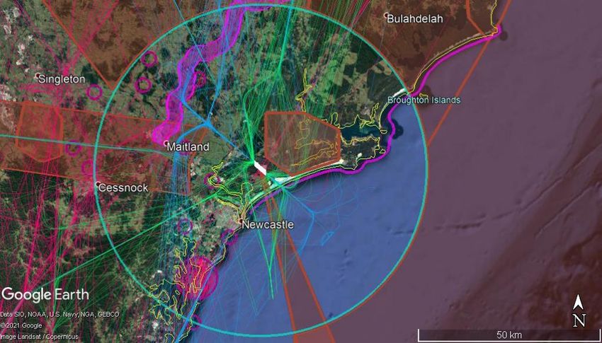
— Currently communities around RAAF Base Williamtown (Newcastle Airport) experience an extensive range of aviation operations:
— Military fast jet training and airborne surveillance operations across the region that require aircraft to fly between RAAF Base
Williamtown and restricted airspace locations, in some cases using defined corridors.
— Jet and non-jet scheduled passenger flight services fly on published flight paths to and from capital city airports (such as
Sydney, Brisbane, Melbourne, Canberra) and regional locations (such as Dubbo, Lord Howe Island, Sunshine Coast).
— Medical operators, such as the Royal Flying Doctor Service, also routinely use Newcastle Airport to connect with regional
locations including Taree, Port Macquarie and Coffs Harbour.
— The broader Hunter region has a high level of general aviation activity, with a dedicated corridor for light aircraft flying Visual
Flight Rules (VFR)1, and recreational aviation areas throughout, including parachuting at Lake Macquarie and flight training at
Maitland Airport.
— There are a number of high altitude arrival and departure air routes that traverse the region and these are used by aircraft
overflying from Sydney to Brisbane, other northern locations and international airports.
1. Visual Flight Rules (VFR) are procedures and rules for how aircraft are to be operated when the pilot uses visual references such as to the ground or —4
water to fly.
Northern Arrivals
                                                                   to Runway 12                          Departures to Brisbane/northern airports

                    Jet and non-jet
                      overflights

                                                                                                                           Northern Arrivals to Runway 30

                                                                                                                                                            Coastal VFR
                                                                                                                                                              Route

                                           VFR Corridor

                                                                                                                            Salt Ash
                                                                                                                         Restricted Area
Flight to/from
    Dubbo

     Jet and non-jet                                         Lake
       overflights                                         Macquarie
                                                          Parachuting
                                                                                                                                                            Military Restricted
                                                                                                                                                                 Airspace

                 Non-jet departures to
                 (Sydney/Bankstown)
                                                                                Jet departures to Southern Airports
                                                                                    (e.g. Canberra, Melbourne)

                                                        Southern Arrivals
                                         (e.g. Sydney, Bankstown, Canberra, Melbourne)

             Figure 1: Range of current operations to/from RAAF Base Williamtown (Newcastle Airport) and across the broader Hunter region. Arrivals (blue), departures
             (green), overflights (pink), general and recreational aviation activities (purple), restricted airspace/areas (red-brown)                                            —5
WILLIAMTOWN (NEWCASTLE AIRPORT) AIRSPACE AND CIVIL
FLIGHT PATH REVIEW
WHAT IS INVOLVED IN FLIGHT PATH DESIGN?

— Flight Path Design is a complex task – and our goal is to design flight paths that safely get aircraft between the runway and the
  overarching ‘network in the sky’.
— RAAF Base Williamtown’s airspace is some of the most complex in the country. In designing new flight paths for civilian
  operations, Airservices must endeavour to do so with the least disruption to the existing military and civilian airspace, and
  general aviation operations.
— We must ensure that the flight paths are safe, compliant with international and national aviation design standards and
  regulations, and are able to be used by the wide range of aircraft that use this airspace. This may include airlines, freight and
  military transport aircraft such as the C130 (Hercules) and C17 (Globemaster).
— We must also minimise the impact of these aircraft operations on the environment and community wherever possible,
  maintaining existing flight paths where able, and introducing new ones that maximise the use of over water procedures.
— To ensure that our design is safe, compliant and environmentally sustainable while also meeting the needs of Defence, the
  airport, aircraft operators and community, we will apply our Flight Path Design Principles throughout the design and development
  process.

                                                                                                                                      —6
WILLIAMTOWN (NEWCASTLE AIRPORT) AIRSPACE AND CIVIL
FLIGHT PATH REVIEW
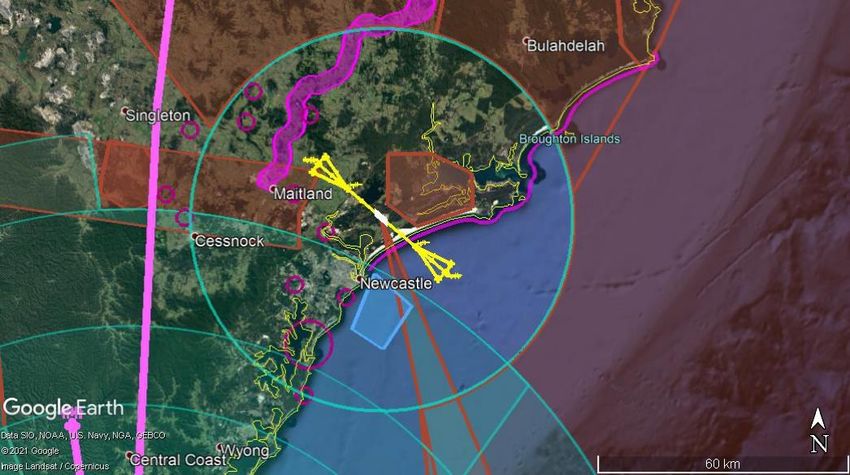
WHAT DO WE NEED TO CONSIDER IN THE DESIGN?
— When designing the flight paths we need to consider the existing infrastructure, design
standards and capabilities of different aircraft types. Our design starts from the runway Approach
funnel
and we work outwards from there.
— As part of the design, we will introduce instrument approach2 flight paths to both ends
of the runway which, under international design standards, extend in a funnel Approach
formation 10 nautical miles or 18 kilometres in either direction from the runway, and funnel
can be used by the vast majority of aircraft operators.
— Aircraft arriving into Williamtown will come off the overarching high level route network
at defined arrival ‘gates’, using standard instrument arrival flight paths that get them
safely into these approach ‘funnels’.
— We may also introduce precise approach flight paths called ‘Smart Tracking’ which
provide extra guidance for pilots and enable aircraft to operate more efficiently. These
approaches are predominantly used by airlines as they require additional on-board
equipment, special flight crew training and authorisation from CASA.
— We will also be revising the existing standard instrument2 departure flight paths from
both ends of the runway at Williamtown, to continue to safely connect Williamtown with
Sydney Airport and other airports across Australia.
2. Instrument flight procedure design and Instrument Flight Rules are procedures and rules which enable aircraft to operate in all weather conditions, —7
including when navigation by visual references is not possibleWILLIAMTOWN (NEWCASTLE AIRPORT) AIRSPACE AND CIVIL
FLIGHT PATH REVIEW
WHAT DO WE NEED TO CONSIDER IN THE DESIGN? VFR Corridor
— In developing our designs we need to ensure we consider military fast jet operations, Salt Ash
Restricted Area
GA operations, Marine One helicopter marine pilot transfer area of operation and Coastal VFR
recreational operations such as parachuting areas. Route
— Additionally, Sydney Airport’s airspace extends north of Sydney to 6 nautical miles
Lake
south of Williamtown airspace. Macquarie Marine One
Parachuting airspace
— Given this close proximity, Sydney Airport operations must also be considered,
particularly Sydney arrival and departure air routes that traverse the Hunter region. Military Restricted
Airspace
— The main arrival route to Sydney from the north operates just to the west of the
Williamtown airspace.
Williamtown Airspace
Sydney Airspace
—8VFR Corridor
Coastal VFR
Route
Salt Ash Williamtown Airspace
Restricted Area
Approach
funnel
Lake
Sydney Arrival Macquarie
Routes Parachuting
Marine One Military Restricted
airspace Airspace
Sydney Airspace
Figure 2: Flight Path Design Considerations. Civil airspace (teal), general and recreational aviation activities (purple), restricted airspace/areas (red-brown),
Sydney arrival paths (pink),instrument approach ‘funnels’ (yellow), Marine One helicopter area of operations (light blue). —9WILLIAMTOWN (NEWCASTLE AIRPORT) AIRSPACE AND CIVIL
FLIGHT PATH REVIEW
WHAT PROCESS DO WE USE?
— We undertake a multi-step flight path change process. A number of screening and assessment steps are involved to progress a
flight path change proposal to implementation. These ensure that the flight paths are safe, operationally feasible, and meet our
environmental responsibilities.
— The changes involve a range of stakeholder engagement activities and all feedback is considered before we progress to final
flight path design development.
— Working with councils across the Greater Hunter Region we have completed a social impact analysis and the findings will be
considered as part of our design process. For high level summaries of our social research findings, visit Engage Airservices and
view our community specific fact sheets for each Local Government Area (LGA).
— These findings are considered, along with design requirements and constraints, in developing an initial preliminary design for the
new flight paths.
— We then environmentally assess the proposed flight paths to determine if there are any potential environmental impacts,
including changes to aircraft operations over communities and the level of noise experienced. We engage with the community
and other stakeholders throughout the process in accordance with our Community Engagement Framework, which has been
developed to provide a rigorous process for delivery of community engagement activity for flight path and associated airspace
changes.
— 10WILLIAMTOWN (NEWCASTLE AIRPORT) AIRSPACE AND CIVIL
FLIGHT PATH REVIEW
WHAT STAGE IS THE FLIGHT PATH REVIEW AT?
— Airservices has recently commenced preliminary design development. This design will be made available for community review
and comment later in the year.
— At this stage, we are providing information to the community about the review and are inviting questions or comments from the
community on areas of specific interest.
— It is important to emphasise that this review will not remove the impact of aircraft operations on the community. As noted, RAAF
Base Williamtown’s airspace is some of the most complex in Australia, and its military and civil aviation functions must be
maintained. However, if there are areas of specific interest to the community that our review of civilian operations should
consider, we welcome community feedback.
— 11WILLIAMTOWN (NEWCASTLE AIRPORT) AIRSPACE AND CIVIL
FLIGHT PATH REVIEW
FOR FURTHER INFORMATION
— For more detailed information on operations across Newcastle and the Greater Hunter Region, visit our Engage Airservices
project page and view our community specific fact sheets for each Local Government Area (LGA).
On the Engage Airservices project page you can also:
— Submit questions about the project.
— Provide input for us to consider in our design and assessment activities through our survey.
Register for Engage Airservices and subscribe to follow the project so you can receive project updates.
— 12You can also read