WILUNA WEST IRON ORE PROJECT - C4 IRON ORE DEPOSIT PART V LICENCE APPLICATION SUPPORTING DOCUMENT
←
→
Page content transcription
If your browser does not render page correctly, please read the page content below
GWR GROUP LIMITED

 WILUNA WEST IRON ORE
       PROJECT
    C4 IRON ORE DEPOSIT
PART V LICENCE APPLICATION
  SUPPORTING DOCUMENT

                    M53/1087

  Proponent:        GWR Group Limited
  Address:          97 Outram Street, WEST PERTH 6005
  Postal Address:   PO Box 517, WEST PERTH 6872
  Contact:          Mick Wilson
                    Exploration Manager, GWR
                    Phone: (08) 9322 6666
                    E-mail: mickw@gwrgroup.com.au

                     March 2021
GWR Group Limited                                                                                    Part V Licence Supporting Document

                                                TABLE OF CONTENTS
                                                                                                                                  Page No
1.0        INTRODUCTION ..................................................................................................................... 4
     1.1          BACKGROUND ...............................................................................................................4
     1.2          OBJECTIVE .....................................................................................................................4
     1.3          LOCATION.......................................................................................................................4
     1.4          OWNERSHIP & LAND TENURE.....................................................................................4
2      ATTACHMENT 1A – PROOF OF OCCUPIER STATUS ............................................................ 7
3      ATTACHMENT 1B – ASIC COMPANY EXTRACT .................................................................... 9
4      ATTACHMENT 2 – MAP OF PRESCRIBED PREMISES ......................................................... 12
5      ATTACHMENT 3B – PROPOSED ACTIVITIES ....................................................................... 13
     5.1          OVERVIEW ................................................................................................................... 13
     5.2          PRESCRIBED PREMISES ........................................................................................... 16
     5.3          KEY INFRASTRUCTURE AND EQUIPMENT ............................................................. 16
     5.4          CRUSHING AND SCREENING PLANT ....................................................................... 16
     5.5          DIESEL & HYDROCARBON STORAGE ..................................................................... 18
6      ATTACHMENT 5 - OTHER APPROVALS AND CONSULTATION ......................................... 20
     6.1          OTHER STATUTORY APPROVALS ........................................................................... 20
     6.2          CONSULTATION .......................................................................................................... 20
7      ATTACHMENT 6A – EMISSIONS, DISCHARGES AND WASTE ........................................... 29
     7.1          POTENTIAL EMISSIONS ............................................................................................. 29
     7.2          RISK ASSESSMENT AND MANAGEMENT SUMMARY ............................................ 29
8      ATTACHMENT 7 – SITING AND EXISTING ENVIRONMENT ................................................. 33
     8.1          RECEPTORS ................................................................................................................ 33
     8.2          SPECIFIED ECOSYSTEMS ......................................................................................... 33
     8.3          CLIMATE ...................................................................................................................... 34
     8.4          REGIONAL SETTING ................................................................................................... 34
        8.4.1     IBRA Region.................................................................................................................. 34
        8.4.2     Soil-Landscape Zone .................................................................................................... 35
        8.4.3     Land Systems ................................................................................................................ 35
     8.5          GEOLOGY .................................................................................................................... 35
     8.6          SOILS ............................................................................................................................ 36
     8.7          SURFACE WATER ....................................................................................................... 36
     8.8          GROUNDWATER ......................................................................................................... 39
        8.8.1     Regional Hydrogeology ................................................................................................. 39
        8.8.2     Local hydrogeology ....................................................................................................... 40
        8.8.3     Groundwater Levels and Flow ...................................................................................... 40
        8.8.4     Mine dewatering and water requirements ..................................................................... 41
        8.8.5     Groundwater Quality ..................................................................................................... 41
     8.9          BIODIVERSITY ............................................................................................................. 43
        8.9.1     Communities ................................................................................................................. 43
        8.9.2     Vegetation ..................................................................................................................... 45
        8.9.3     Flora .............................................................................................................................. 49
        8.9.4     Fauna ............................................................................................................................ 49
        8.9.5     Short-Range Endemics (SRE) ...................................................................................... 49
        8.9.6     Subterranean Fauna ..................................................................................................... 50
9      ATTACHMENT 9 – PROPOSED FEE CALCULATION............................................................ 51
10     BIBLIOGRAPHY ........................................................................................................................ 52

FIGURES
Figure 1: Location of Wiluna West Project ........................................................................... 5

                                                                          ii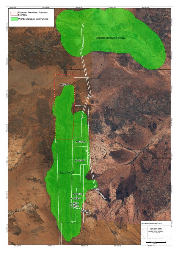
GWR Group Limited                                                                              Part V Licence Supporting Document

Figure 2: Project Tenements currently held by GWR........................................................... 6
Figure 3: Prescribed Premises map showing emission and discharge points .................... 12
Figure 4: Overall Project site layout................................................................................... 14
Figure 5: Site layout of crushing/screening plant area ....................................................... 15
Figure 6: Crusher Process Flowsheet ............................................................................... 18
Figure 7: C4 Catchments Map (from Rockwater 2020) ...................................................... 38
Figure 8: Surface Water Drainage Infrastructure Map (from Rockwater 2020b) ............... 39
Figure 9: Water levels in exploration holes (from Pennington Scott 2013) ......................... 41
Figure 10: Location of Wiluna West PEC .......................................................................... 44
Figure 11: Vegetation Ccommunities and Priority flora in the proposed prescribed premises
.......................................................................................................................................... 48

TABLES
Table 1: Tenements part of the C4 Project Prescribed Premises ........................................ 4
Table 2: Summary of the C4 Project (Stage 1) .................................................................. 13
Table 3: Key Equipment and Infrastructure to be installed................................................. 16
Table 4: Crushing Plant design and operation requirements ............................................ 17
Table 5: Statutory approvals required for the C4 Project ................................................... 20
Table 6: Stakeholder consultation undertaken................................................................... 22
Table 7: Risk assessment and management summary for the crushing and screening plant
.......................................................................................................................................... 30
Table 8: Risk Criteria......................................................................................................... 32
Table 9: Receptors and distance from activity boundary ................................................... 33
Table 10: Specified Ecosystems and Designated Areas.................................................... 33
Table 11: Soil units in the Project area .............................................................................. 36
Table 12: Results of groundwater analysis ........................................................................ 43
Table 13: Vegetation units within the proposed prescribed premises ................................ 45

                                                                     iii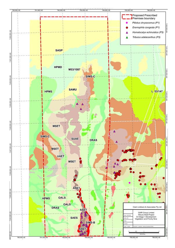
GWR Group Limited                                                  Part V Licence Supporting Document

      1.0        INTRODUCTION
      1.1        BACKGROUND
      GWR Group Limited (GWR) own the Wiluna West Project which comprises eight iron ore deposits
      over the two Banded Iron Formation (BIF) ridges (Ridges B and C as classified by GWR). Gold
      deposits are known to occur in the swales between the BIF ridges and there are numerous Gold
      Deposits that have been identified (13 in resource category).
      Due to known occurrences of both minerals within the tenement package and depending on which
      commodity was being put forward the Project has been referred to as both the Wiluna West Gold
      Project (WWGP) and the Wiluna West Iron Ore Project (WWIOP).
      There is a large iron ore resource (130Mt @ 60% Fe) with an associated reserve of 69.2Mt @
      60.3% Fe and there has been extensive work completed over the last 10 years in developing the
      WWIOP with various studies performed with two distinct options:
      •     Stage 1 – 1 -2 Mtpa operation looking at high grade deposits with low set up costs, utilizing a
            mobile crushing and screening plant and road transport to either establish rail platforms or direct
            to the Geraldton or Esperance ports.
      •     Stage 2 – 5-7 Mtpa operation looking at 10 Year mine Life and full reserve extraction, fixed
            infrastructure on site but very dependent on major upgrade of rail and port facilities (Oakajee).

      GWR has approval for:

      •     a 10 Mtpa development involving mining of the Bowerbird, C3 and C4 iron ore deposits (Reg
            ID 55179); and
      •     a 1.5Mtpa development of the C4 deposits high grade iron ore (referred to as Stage 1) which
            includes a 18.6 km haul road, a crushing /screening plant and associated infrastructure (Reg
            ID 86015)
      •     the construction of a crushing/screening plant (W6444/2020/1).
      Construction works of the crushing/screening were completed in December 2020 with
      commissioning being completed in January 2021. GWR intend on operating the crushing/screening
      plant under a Part V operating licence.
      1.2        OBJECTIVE
      As part of the C4 (Stage 1) iron ore deposit development, GWR intends to operate the following
      prescribed premises:
      •     Category 5 - Processing or beneficiation of metallic or non-metallic ore (Modular crushing and
            screening plant)

      This document has been prepared to support the Licence application. Subject to approval, the
      expected commencement date is scheduled for Q1 2021.

      1.3        LOCATION
      The Project is located approximately 700 kilometres northeast of Perth and 40 kilometres
      southwest of Wiluna in the north-eastern Goldfields of Western Australia (Figure 1).

      1.4        OWNERSHIP & LAND TENURE
      The Project is located within M53/1087 which is 100% owned by GWR Group Limited (Table 1,
      Figure 2).

                       Table 1: Tenements part of the C4 Project Prescribed Premises

                                                       4
GWR Group Limited                                      Part V Licence Supporting Document

       TENEMENT     OWNER               DATE GRANTED        EXPIRY DATE            AREA
       M53/1087     GWR Group Limited   23/09/2010          22/09/2031             6343.37 ha

                            Figure 1: Location of Wiluna West Project

                                             5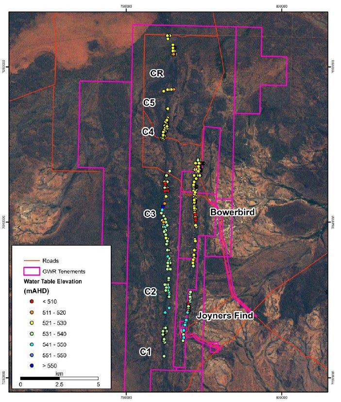
GWR Group Limited                                 Part V Licence Supporting Document

                    Figure 2: Project Tenements currently held by GWR

                                         6
GWR Group Limited                                              Part V Licence Supporting Document

2       ATTACHMENT 1A – PROOF OF OCCUPIER STATUS
Details of the Mining Lease (M53/1087) to which this application relates, providing proof of
the occupier status, are provided on the following page.

                                             7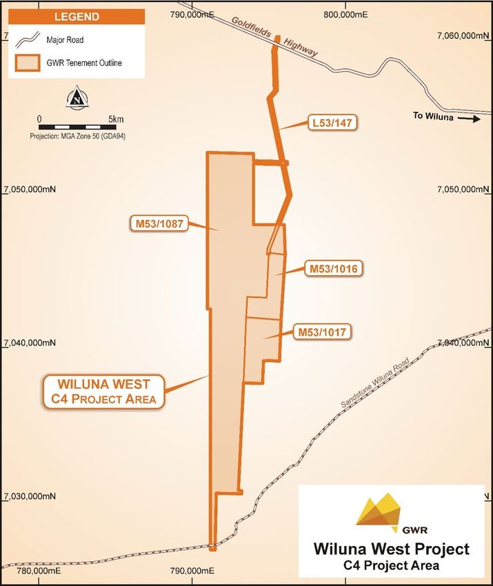
GWR Group Limited       Part V Licence Supporting Document

                    8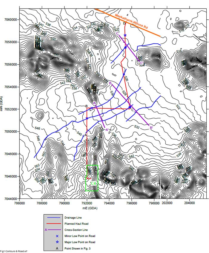
GWR Group Limited                                         Part V Licence Supporting Document

3 ATTACHMENT 1B – ASIC COMPANY EXTRACT
A current company information extract for GWR Group Limited and company details from the ASIC
website is provided below.

                                              9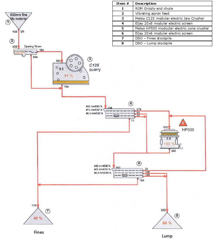
GWR Group Limited        Part V Licence Supporting Document

                    10
GWR Group Limited Part V Licence Supporting Document
11GWR Group Limited Part V Licence Supporting Document
4 ATTACHMENT 2 – MAP OF PRESCRIBED PREMISES
Figure 3: Prescribed Premises map showing emission and discharge points
12GWR Group Limited Part V Licence Supporting Document
5 ATTACHMENT 3B – PROPOSED ACTIVITIES
5.1 OVERVIEW
A summary of the C4 (Stage 1) Project is provided in Table 2 with an overall site layout provided
as Figure 4 and layout for the crushing/screening plant provided in Figure 5.
The initial first year production is anticipated to be 1 Mtpa with the potential to expand production
to 1.5Mtpa with the progression of a cutback at C4 and possibly adjacent deposits at a later
date.
Table 2: Summary of the C4 Project (Stage 1)
Element Description
C4 (Stage 1) Project Ore 976,000 t @ 62% Fe
Mine Life 12 Months (19 months including construction, operation and
rehabilitation)
Mining method Open pit
Total waste rock 891,898 t
Depth of pit ~ 40m
Depth of water table ~ 50m (40-60m Range in C4 Area)
Area of disturbance including 101.7 ha
access (Stage 1)
Water Supply for operations Water bores (C4PB01 & BBPB01)
Processing Modular crushing and screening plant (1-1.5 Mtpa capacity)
Power generation Portable diesel-powered generators on site
Accommodation Rosslyn Hill Camp (off-site)
Construction commencement Q4 2020
13GWR Group Limited Part V Licence Supporting Document
Figure 4: Overall Project site layout
14GWR Group Limited Part V Licence Supporting Document
Figure 5: Site layout of crushing/screening plant area
15GWR Group Limited Part V Licence Supporting Document
5.2 PRESCRIBED PREMISES
As part of the C4 development, GWR intends to operate the following prescribed premises:
• Mobile crushing and screening plant (Category 5) – 1.5 Mtpa (maximum).
The prescribed premises boundary and discharge points are shown in Figure 3.
5.3 KEY INFRASTRUCTURE AND EQUIPMENT
The key infrastructure and equipment is summarised in Table 3, with further detail specific to
the plant provided in the following sections.
GWR has constructed a stormwater catchment trench at the western end of the
crusher/stockpile area which slopes down towards. This will prevent potentially contaminated
stormwater from the plant/ROM area flowing into the surrounds.
After a rain event the stormwater will be pumped out and transported to the turkey’s nest.
GWR will ensure a pump with sufficient pumping capacity is maintained to ensure the trench
does not overflow.
Table 3: Key Equipment and Infrastructure to be installed
Category Equipment and Infrastructure to be installed
5 Crushing/Screening Plant
A mobile crushing and screening plant to provide two-stage crushing and screening
and a combination of diesel/electric powered modular mounted crushers, screens
and portable conveyors.
5.4 CRUSHING AND SCREENING PLANT
The plant will process the ore at rate of just under 1Mtpa (dry tonnes) (maximum 1.5 Mtpa).
Ore will be hauled to the ROM via a 1 km two-way haul-road from the open pit by the mining
fleet and stockpiles as directed.
All ore will be transported from the pit to various ROM stockpiles which may demarcate
different ROM grades and ore characteristics (e.g. high grade/low grade). The ROM will be
under the control of the ROM loader operator and traffic management will ensure positive
communication prior to entry. Ore will be processed through a mobile crushing and screening
circuit to produce two distinct ore products, Coarse Ore (Lump) and Fines stockpiles, with a
process flowsheet shown in Figure 6. Based on information available for stage 1 the crushing
and screening process is deemed fit for purpose.
The product will be stacked in separate stockpiles (Lump and Fines) and selectively removed
offsite via road trains to Geraldton.
The ROM stockpiles will have a total capacity of approximately 150,000 tonnes of ore and are
anticipated to be relatively dry. Dust suppression at the ROM will be achieved via the
installation of water sprays and the mobile water truck with expect moisture of between 5-8%
to minimise dust generation. Additional stockpile capacity of 50,000 tonnes will be in the DSO
products stockpiles to the west of the plant. Water sprays will be installed around the product
area to minimise dust generation.
Ore processing will consist of crushing and screening of the ore through a modular constructed
two-stage crushing and screening plant to produce lump and fines using an electric powered
modular mounted crushers, screens and portable conveyors. The plant will produce two
products: a lump product which is between 31.5mm and 6.3 mm product and a fine product (-
6.3 mm).
16GWR Group Limited Part V Licence Supporting Document
The ore will be fed into the hopper of the primary crusher using a front-end loader. The crushed
material from the primary crusher will then fed directly to a screen, set for a 32mm split size.
The undersize material will report to the secondary screen while the oversize material will
report to the secondary crusher. The undersize material from the secondary screens will report
to the fine’s product stockpile and the oversize material will report to the lump product
stockpiles.
Key design features of the plant design include plant operation is based on a single 12-hour
shift, 7 days per week roster. There is ample capacity in the circuit to increase production to a
24-hour, 7 day a week basis.
The ROM pad will cover an area (100m x 200m) with a 6 m high steel retaining wall located at
the northern end of the ROM pad. This will allow the ore bin apron feeder module to abut
against a 40 m long, 15 m wide ramp inclined at 10% grade to be feed by frontend loader.
Two stacker conveyors will transfer ore from the crushing and screening plant onto the Fines
and Lump stockpiles in one direction. The stacker conveyors will operate a 600mm wide belt
which will be equipped with dust suppression sprays.
Front end loaders will be fitted with bucket load cells to control loading operations for main
road compliance. An additional weigh bridge is located at the Rosslyn office area for secondary
and spot checks (outside of the Project area).
Table 5 summarises the crushing/screening plant design and operation requirements.
Table 4: Crushing Plant design and operation requirements
Infrastructure Requirements
Design and construction
Crushing/Screening • Primary Crusher and ROM pad
Plant • Secondary crusher trailer and 10m hopper/feeder
• Screening trailer and 10m hopper feeder
• Temporary lump stacker
• Temporary fine stacker
Commissioning and Time-limited operations
Crushing/Screening • Water will be added to the process to achieve approximately 5% moisture
content to minimise dust generation.
Plant
• Dust suppression sprinklers and sprays will be installed at the ROM feed
hopper and transfer points to control levels of fugitive dust and will be
operational.
• Water trucks will be available and used around the plant and on the ROM
and roads as required to minimise fugitive dust emissions.
Product stockpile • Dust suppression sprinkler and sprays to control levels of fugitive dust.
• Maximum moisture levels of the final product will be controlled to maintain
operational efficiency from road haulage vehicles and adjusted for seasonal
conditions
17GWR Group Limited Part V Licence Supporting Document
Figure 6: Crusher Process Flowsheet
5.5 DIESEL & HYDROCARBON STORAGE
All hydrocarbons and chemicals will be located within bunded areas or on drip trays to contain
any potential spills. Bulk fuel storage will be within a self-contained, double-skinned storage
tank. They will be two Diesel Storage facilities onsite, one located near the power pack for the
Crushing and Screening facilities and the second for the mobile equipment for mining.
18GWR Group Limited Part V Licence Supporting Document
Waste oil will be stored in a tank and removed from site for recycling by a licensed collection
service. Oil filters and hydrocarbon-contaminated rags will be collected in approved
receptacles and removed from site to an appropriate facility at Rosslyn Hill.
Two self-bunded diesel storage facilities are to be installed at the C4 site. One of the diesel
storage facilities will be located adjacent to the power-pack for the crushing and screen plant.
The other 110kl storage tank will be location near the go-bay to facilitate the mining fleet and
miscellaneous mine vehicles requirements.
Self-bunded day tanks will be installed to provide fuel to stand-alone diesel generators (e.g.
producing water bores) at their respective locations where required.
All chemical and reagents classed as dangerous goods will be stored in accordance with the
requirements of the Dangerous Goods Safety Act 2004 and the Dangerous Goods Safety
(Storage and Handling of Non-explosives) Regulations 2007. Spill kits will be made available
for use to contain hydrocarbon spills.
19GWR Group Limited Part V Licence Supporting Document
6 ATTACHMENT 5 - OTHER APPROVALS AND CONSULTATION
6.1 OTHER STATUTORY APPROVALS
Table 5 summarises the statutory approvals required for the C4 Project.
Table 5: Statutory approvals required for the C4 Project
Relevant Legislation Environmental Relevant approval requirement
Factor
regulated/affected
APPROVALS
Environment Protection and Biodiversity EPBC Act referral (EPBC 2020/8696) made to the
Biodiversity Conservation Act 1999 Land and Soils Federal Department of Agriculture, Water and the
Environment (DAWE), as there is one species listed
under the EPBC Act at the Project (Malleefowl -
Leiopoa ocellata). DAWE decision on 31/7/20 that
Project is ‘not a controlled action’ and no further
assessment under EPBC Act is required.
Environmental Protection Act 1986 Biodiversity A large scale 10Mtpa Project (disturbance 2,600 ha)
(EP Act) Part IV (and Administrative Land and Soils was referred to the EPA in December 2012 and
Procedures 2012) assessed as ‘Not Assessed – Public Advice Given on
22 April 2013.
No significant impact to any environmental factors
resulting from the Project.
Environmental Protection Act 1986 Biodiversity GWR has two active clearing permits that cover the
(Part V) C4 development and associated haul road:
Environmental Protection (Clearing 1. CPS 6726/2 – 1,290 ha (expires August 2026)
of Native Vegetation) Regulations
2. CPS 8915/1 – 60 ha (expires July 2023).
2004
Mining Act 1978 and Mining Biodiversity GWR has an approved Mining Proposal (MP) and
Regulations 1981 Land and Soils Mine Closure Plan (MCP) (Reg ID 86015) for the C4
development including the crushing/screening plant
Rehabilitation and as outlined in this WApp application.
Mine Closure GWR also has an approved MP-MCP (Reg ID 55179)
for larger scale development at C4 (in addition to
Bowerbird and C3 deposits).
Rights in Water and Irrigation Act Water resources GWR has a DWER (formerly DoW) Licence to take
1914 water:
• GWL 202977(1) issued 27/06/2019 for the
purposes of dust suppression
Mines Safety & Inspection Act 1994 Safety A Project Management Plan will be submitted to the
and Mining Safety & Inspection DMIRS in accordance with this Act and Regulations.
Regulations 1995 All operations will occur in accordance with the Act
and Regulations.
6.2 CONSULTATION
GWR has ongoing consultation with key project stakeholders and a summary of the
consultation undertaken to date is presented in (Table 6). No recent discussions have been
held with DWER.
A major stakeholder in the project are the Wiluna Native Title holders represented by Tarlka
Matuwa Piarku Aboriginal Corporation (“TMPAC”). Consultation with TMPAC is defined by
a Mining Agreement and Cultural Heritage Management Plan (“CHMP”). Copies of the
Mining Proposal will be provided to TMPAC in accordance with the above agreements. The
Wiluna Native Title holders were also briefed on the project when they participated in
Heritage surveys of the area and through the Relationship Committee and various
presentations to the TMPAC Board.
20GWR Group Limited Part V Licence Supporting Document
The other major stakeholder in the C4 Project is the current pastoral station owner, Toro
Energy. Toro Energy are aware of GWR’s plans and has voiced no objections or concerns.
GWR will continue to liaise with stakeholders during operations and in relation to closure
during the life of the project and will provide updates on closure developments on an
ongoing basis.
Consultation with stakeholders will continue throughout the life of the Project to ensure
stakeholder concerns and objectives are accounted for and the Register will be updated to
reflect further input from stakeholders.
21GWR Group Limited Part V Licence Supporting Document
Table 6: Stakeholder consultation undertaken
Date Stakeholder* Description of Stakeholder comments/issues Proponent response and/or resolution
Consultation
14/02/06 DEC Site Visit Site visit to show DEC the Wiluna West site. As a result of this site meeting, a quadrat-
• Dr Neil Gibson based sampling methodology was obtained
by Jim’s Seeds, Weeds and Trees from Dr.
GWR representatives Gibson.
23/05/07 DEC Project briefing Overview of the Project provided. N/A
GWR representatives in Kalgoorlie
6/11/08 DEC Project briefing Briefing outlined the results of the biophysical surveys Subsequent survey work has been
• David Pickles undertaken to date at the Project. undertaken by GWR.
• Sandra Thomas DEC raised concern over adequacy of 2006 SRE survey
GWR representative (based on timing of survey). Further work suggested.
April and DEC Meeting Consultation with the DEC regarding the flora species Sida Further survey work undertaken by KLA (in
August • Western Australian picklesiana (formerly Sida sp. Wiluna). The species was first conjunction with the WA Herbarium) which
2010 Herbarium recorded by the DEC in the 2006 quadrat survey and later recorded additional populations of the
GWR representatives given a Priority 1 rating. species extending up to 200km from the
Discussions were undertaken with the Curator and staff of GWR Project (This species has
the WA Herbarium regarding two undetermined specimens subsequently been downgraded to a Priority
showing superficial similarities to this species (considered a 3 species).
new taxon at this time).
2010 Central Desert Land Council Correspondence Provide copy of Mining proposal with conceptual MCP. No concerns or issues.
Representing Tarlpa NTC
2010 Wiluna Shire council members Meeting Presentation on the Wiluna West project and JWD. No concerns or issues.
GWR representatives
Ongoing Tarlpa Native Tile Claimants Triennial Regular briefings with the NT relationship committee. No concerns or issues.
from 2010 Meetings
Ongoing Lupton family (Lake Way Informal Periodical Informal discussion giving updates on projects. No concerns or issues.
from 2010 Pastoralist sub-leasee) discussions
about project
2010 DMP Meeting Provided overview of JWD Project before submission. Comments provided and acted on.
• Janine Cameron
27/01/12 & DMP Consultation Advice from the NVB, DMP (Ryan Mincham) sought
30/01/12 • Ryan Mincham regarding the requirement for an Autumn fauna survey.
GWR representatives
22GWR Group Limited Part V Licence Supporting Document
Date Stakeholder* Description of Stakeholder comments/issues Proponent response and/or resolution
Consultation
20/02/12 EPA Meeting - GWR The Chairman and Mark Jefferies raised the following points: All agencies were met with and
• Dr Paul Vogel met with the 1. Metalliferous drainage at neutral pH – looking at AMD was issues addressed in the
• Mr Mark Jefferies OEPA to correct but must include neutral drainage for such subsequent submissions.
GWR discuss the elements as selenium, etc.
• Craig Ferrier Wiluna West
2. Ensure that the studies investigate the cumulative impacts
• Mick Wilson Project
and compare to the regional environment.
• Paul Leidich
KLA 3. Contact DEC to ensure they are happy with the lack of
• Keith Lindbeck autumn fauna surveys (as with the DMP).
4. Contact DEC to obtain comment on the impact of the
project on the PEC.
5. Contact DoW to discuss availability of groundwater for the
project and potential impact on other users.
6. Discuss clearing permit requirements with DMP
7. Discuss implications of export through the Port of
Esperance with the DoT.
21/02/12 DEC Correspondence Correspondence with David Pickles (letter), DEC seeking
and 9/03/12 • David Pickles (letter and advice on the requirement for autumn fauna survey at the
• Sandra Thomas email) project (as three Spring fauna surveys have been undertaken
previously).
Email correspondence received from Sandra Thomas, EMB,
DEC advising that: “Based on the available information, an
Autumn fauna survey does not appear to be required.”
20/06/12 DoW Meeting GWR presented a summary of the Project, hydrogeological N/A
• Yolanda Brookes investigations and the proposed water supply and
• Chris O'Boy dewatering strategy. The strategy for water licensing was
• James MacIntosh presented.
• Tina Taraborrell The DoW was supportive of the proposed approach noting
GWR representatives that all key DoW requirements had been addressed.
26/06/12 DEC Correspondence Correspondence to David Pickles (letter), providing results of
• David Pickles (letter) the SRE 2011 survey.
28/08/12 DEC Meeting GWR provided an update on the Project and advice sought GWR provided the required information to
• Sandra Thomas from the DEC on the impact of the Project on the Wiluna the DEC.
• Val English West PEC. DEC outlined the information they require
• Julie Futter (vegetation and flora data) to enable them to make their
• Daniel Coffey assessment on the impact of the Project.
23GWR Group Limited Part V Licence Supporting Document
Date Stakeholder* Description of Stakeholder comments/issues Proponent response and/or resolution
Consultation
GWR representatives
• Craig Ferrier
• Mick Wilson
KLA
• Keith Lindbeck
20/02/13 Mid-West Road Safety Meeting JWD Project and proposed road transport objectives. Ongoing discussions.
21/02/13 Committee
10/04/13 Mt Magnet Shire
10/07/13 Meekatharra Shire
26/02/14 Cue Shire
Menzies Shire
Yalgoo Shire
9/04/13 Sandstone Shire Meeting JWD Project and proposed road transport objectives. Ongoing Discussions.
31/10/13 MRD
28/11/13 GWR representatives
29/01/14
6/02/14
19/02/14
7/03/14
7/05/14
21/11/13 Wiluna Shire Meeting Presentation of project and discussions on road transport. Comments provided and acted on.
27/11/13 GWR representatives
28/01/14
5/02/14
18/02/14
18/02/14 Sandstone Shire Public meeting JWD Project and proposed transport objectives. Comments provided and acted on.
General Public
GWR representatives
2014 Central Desert Land Council Correspondence Provide copy of Mining MCP for any feedback. No concerns or issues.
Representing Tarlpa NTC
6/03/14 Native Title Claimants Annual General Annual Function for all claimants. No concerns or issues.
GWR representatives Meeting
7/04/14 Pastoralist Exploration Exploration objectives. Consent to program.
• Jim Quadrio Activities
• Alan Bloor
GWR representatives
24GWR Group Limited Part V Licence Supporting Document
Date Stakeholder* Description of Stakeholder comments/issues Proponent response and/or resolution
Consultation
September Toro Energy (Pastoralist owner Correspondence Provided synopsis of Mine Closure Plan. No concerns or issues.
2014 for Lake Way Station)
2015 Central Desert Land Council Meeting Presented WWIOP Mining Proposal for review. No concerns or issues.
Representing Tarlpa NTC
2018 and Wiluna Shire Ongoing Status of Golden Monarch project and use of Shire Roads Ongoing discussions and no issues
2019 • Councillors meetings and
• CEO discussions
• Executive Manager
Technical Services
5/07/18 Wiluna Native Title holders TMPAC Board Provided project update, which specifically included the No concerns or issues
Meeting proposed open pit at Golden Monarch
8/08/18 DMIRS Phone Advice sought regarding definition of ‘Fauna specialist’ as GWR submitted a letter requesting approval
• Ryan Mincham call/Email stated in CPS 4006/2 as GWR has and intends to utilise the for the Aboriginal Martu women to complete
Aboriginal Martu women to undertake targeted Malleefowl the survey (former and future) with the CPS
27/08/18
assessments at the Project. 4006/3 application.
Ryan spoke to Lesley Polomka about this scenario and they
both agreed that the Aboriginal Martu women would be
suitably qualified to undertake this work. Ryan has provided
some further advice in relation to the process for seeking
approval as per the conditions on CPS 4006/2
19/08/2018 Wiluna Native Title holders Survey Ethnographic survey over proposed C4 Haul road Compliant with Cultural Heritage
Management Plan
January Bill (Manager) for Lupton Informal Advised that we were seeking to commence mining at No concerns or issues
2019 family Meeting Golden Monarch
27/02/19 Wiluna Native Title holders Wiluna Native Provided project update, which specifically included the No concerns or issues
Title holders proposed open pit at Golden Monarch
25/03/19 DBCA Phone call CLA contacted David to advise him of GWR’s intention to Confirmed source of record and advised that
• David Pickles start mining at Golden Monarch, update on recent Sida DBCA is only aware of their occurrence at
survey findings and to seek advice on the source of Boodie Matuwa (>200km north) where they were re-
record (Bettongia. lesueur.graii) which shows in the DBCA introduced. David advised he is relocating
threatened fauna search at Wiluna West. to the Karratha DBCA office within the next
fortnight.
10/4/19 – Wiluna Native Title holders Survey Heritage survey over portion of proposed Golden Monarch Compliant with Cultural Heritage
12/4/19 footprint and Eagle – Emu deposits Management Plan
25GWR Group Limited Part V Licence Supporting Document
Date Stakeholder* Description of Stakeholder comments/issues Proponent response and/or resolution
Consultation
6/05/19 Toro Energy (owner of Lake Email Advised that we were intending to commence mining at Acknowledged receipt and awaiting
Way Station) Golden Monarch and wished to convene meeting. response
• Greg Shirtliff
22/05/19 Wiluna Shire Meeting Meeting, advised of Wiluna West project status and intention No issues raised.
• President to commence mining at Golden Monarch
• CEO
• GWR representatives
27/06/19 DMIRS Email DMIRS requested further information in relation to the GWR clarified that the waste from the two
• Maree Doyle correspondence Golden Monarch MP (Reg ID 80069) including: deposits is similar.
• Rob Irwin and Meeting • Interaction between Golden Monarch and JWD pits GWR committed to complete a detailed
GWR • Design of Golden Monarch WRD if JWD does not Golden Monarch WRD design and
• Mick Wilson proceed and confirmation of waste characteristics requested a further meeting to confirm the
• Clarification of areas where existing suitability of the design.
disturbance>approved disturbance. Clarification of disturbance areas will be
GWR arranged a meeting to discuss these items. provided to DMIRS.
9/07/19 DMIRS Meeting GWR presented the design of the Golden Monarch WRD to Golden Monarch MP and Mine Closure Plan
• Maree Doyle DMIRS. DMIRS provided advice in relation to back sloping will be updated with this design information
• Rob Irwin the top surface of the WRD and other suggestions for and resubmitted.
GWR inclusion in the MCP. GWR will provide an outline of the
• Mick Wilson The differences in existing and approved ‘disturbance’ were disturbance on L53/115 (under separate
briefly discussed and DMIRS requested an outline of events cover) for DMIRS review.
relating to this to assess.
19/08/19 Wiluna Native Title holders Survey Ethnographic survey over proposed C4 Haul road Compliant with Cultural Heritage
Management Plan
6/09/19 Wiluna Shire Councillors Council Meeting Presented update on Wiluna West project including intention No Issues
Wiluna Executives to start mining at Golden Monarch
General public
GWR representatives
12-16 Wiluna Native Title holders Survey Archaeological survey over C4 deposit and haul road C4, C3, Compliant with Cultural Heritage
September Bowerbird, Eagle, Emu and Golden Monarch Management Plan
2019
November Engagement with Wiluna Shire Meetings, email Establishment and finalising a Road Access Agreement Finalised May 2020
2019 to management, CEO, Works and formal
May 2020 Manager and Shire President agreement
26GWR Group Limited Part V Licence Supporting Document
Date Stakeholder* Description of Stakeholder comments/issues Proponent response and/or resolution
Consultation
14/11/19 • DMIRS – Maree Doyle Phone DMIRS queried timing of submission of Eagle and Emu MP Submission delayed – this MP drafted in
• CLA – Belinda Clark as DMIRS are advising proponents that MP’s produced in accordance with DMIRS (2020) guidance.
accordance with DMP (2006) guidelines will only be
accepted until February 2020.
20/11/19 • DMIRS Meeting Meeting held for GWR to provide overview of Eagle-Emu DMIRS advice was incorporated into the
Maree Doyle deposits and ascertain the most efficient approval pathway MP.
• Richard Smetana for clearing permit (and MP).
GWR DMIRS advised that Jan De Lange is the most appropriate
• Mick Wilson contact for geotechnical advice.
• Adrian Costello
CLA
• Keith Lindbeck
Belinda Clark
10/12/19 DMIRS Email Email request for clarification regarding inclusion of GWR have considered this advice in
• Maree Doyle Bowerbird infrastructure in the Eagle-Emu MP. DMIRS preparation of this MP. As there are no
preliminary advice is that “inclusion of the Bowerbird immediate plans to develop Bowerbird pit, it
infrastructure in the MP would provide greater flexibility with has been left out of this MP.
land use (given the overlaps) or shifts in location/construction
of proposed infrastructure (provided the alterations do not
trigger the need for re-submission of an MP) once
development commences, mine closure planning,
compliance and reporting purposes”.
25/02/2020 Youno Downs Station Phone Project update Very supportive
• Marilyn Bernhardt
25/02/2020 Toro Energy (owner of Lake Email Request to catch up regarding project status No response
Way Station)
• Greg Shirtliff
12/03/2020 Wiluna Shire Meeting Provided update on Wiluna West project including JWD, No issues
• DCEO Golden Monarch, Eagle, Emu and C4
• EA
GWR
• Mick Wilson
27/03/2020 Youno Downs Station Site Visit Site visit Golden Monarch, Eagle, Emu, C4 and C4 haul road Highly supportive
• Colin Bernhardt
27GWR Group Limited Part V Licence Supporting Document
Date Stakeholder* Description of Stakeholder comments/issues Proponent response and/or resolution
Consultation
April 2020 • DMIRS – Maree Doyle Phone DMIRS contacted to advise of the two MP’s currently being DMIRS acknowledged that an MCP is
CLA – Belinda Clark prepared for submission at the Project: required to submitted with each MP. It was
1/ Eagle-Emu – DMIRS advised this submission has been recommended that the C4 haul road MCP be
delayed submitted separately (rather than a joint
2/ proposed 18.6 km haul road from the C4 deposit - DMIRS MCP).
advised that a smaller scale operation at C4 is now
considered viable and the proposed haul road will enable
transport of iron ore to either the Geraldton or Esperance
Port.
DMIRS queried if the haul road wasGWR Group Limited Part V Licence Supporting Document
7 ATTACHMENT 6A – EMISSIONS, DISCHARGES AND WASTE
7.1 POTENTIAL EMISSIONS
Potential emissions arising from the operation of the prescribed premises are:
• noise;
• dust; and
• contaminated stormwater resulting from plant/ore stockpile area to the surrounds.
The management measures and controls to be implemented are summarised in the risk
assessment presented in Table 7.
7.2 RISK ASSESSMENT AND MANAGEMENT SUMMARY
A summary of the potential environmental risks relevant to the Licence application and the
associated environmental management measures to be implemented to reduce these risks to
an acceptable level, are summarised in Table 7.
Based on GWR’s assessment of the Project siting (Attachment 7), it is considered that
vegetation, fauna, soil and groundwater are the only receptors. The closest residence dwelling
(pastoralist) is >20km away and the closest town is Wiluna (approximately 25 km away) from
the prescribed premises.
The residual risk assessment ratings are consistent with the risk assessment matrix used by
DWER as shown in (Table 8).
29GWR Group Limited Part V Licence Supporting Document
Table 7: Risk assessment and management summary for the crushing and screening plant
Residual Risk
LIKELIHOOD
CONSEQUQ
Potential Emission Type and Impact Assessment/
Activity Potential Receptors Potential Pathway Potential Adverse Impacts
PRIORITY
Source Proposed Controls
OPERATIONS OF CRUSHING/SCREENING PLANT
Operation of Excessive dust generation from Flora and vegetation Air / wind dispersion Decline in vegetation health and Water to be used for dust suppression is not saline.
Low
Slight
Unlikely
Crushing/screening crushing/screening plant, equipment fauna habitat
plant (including Crusher installed with appropriate water sprays to reduce dust
movements and ore handling and ore
stockpiling of ore) generation.
stockpiles
Dust suppression sprinklers and sprays will be installed at the ROM
feed hopper, transfer points and on the product stockpile to control
levels of fugitive dust.
Maximum moisture levels of the final product will be controlled to
maintain operational efficiency from road haulage vehicles.
Water trucks will be used around the plant and on the ROM and roads
as required.
Daily inspection of plant area will include observation of dust
assessment and walking of plant site perimeter.
Noise – Local fauna Air / wind dispersion Noise may disrupt foraging Closest sensitive receptor (rural residential dwelling) is located >20 km
Low
Insignifica
t
Unlikely
behaviour from the Project
Equipment, machinery and vehicles
used during construction works Operations will comply with the Environmental Protection (Noise)
Regulations 1997.
Light spill generated during operation Local fauna Air dispersion. Light spill may disrupt nocturnal Lighting design in areas that require night lighting will ensure light is
Low
Insignifica
Unlikely
of plant foraging behaviour directed to work areas and minimal light spill occurs (including use of
directional lighting and covered lenses).
30GWR Group Limited Part V Licence Supporting Document
Residual Risk
LIKELIHOOD
CONSEQUQ
Potential Emission Type and Impact Assessment/
Activity Potential Receptors Potential Pathway Potential Adverse Impacts
PRIORITY
Source Proposed Controls
Release of contaminated storm water Soil and vegetation adjacent Movement of Soil contamination inhibiting Ore stockpile and crusher area is bunded to prevent surface flows
Minor
Medium
Unlikely
runoff to the environment to the area contaminated surface vegetation growth and survival, outside of this area with all runoff directed towards the trench located
water runoff to land and and health impacts to fauna. at the southern end of the plant area.
Groundwater of beneficial use
– none, groundwater is ~50 m infiltration to groundwater Contamination of groundwater. Bund is constructed around the plant area.
bgl Hydrocarbon or chemical
All hydrocarbons and dangerous goods on site will be stored and
spill
handled according to the applicable sections of the Dangerous Goods
Safety Act 2004, Dangerous Goods Safety (Storage and Handling of
Non-Explosives) Regulations 2007 and Dangerous Goods Safety
(Explosives) Regulations 2007.
Chemical storage areas will be bunded with a containment capacity
equivalent to 110% of the capacity of any tank or 25% of the total
capacity of an interlinked system.
Regular inspection of bunded areas to ensure capacity is maintained.
Washdown effluents will report to oil/water interceptor/separator.
Spillages will be cleaned up and disposed of as per appropriate SDS,
relevant environmental and safety guidelines and the site’s
environmental procedure.
Absorbent materials will be used under machinery which is likely to leak
oil while under service or repair in the workshop or on stand-down.
Any release which is likely to cause pollution or environmental harm will
be reported to the DWER in accordance with Section 72 of the EP Act.
Generation of excessive gaseous Local fauna Air dispersion. Amenity impacts Ensuring motorised equipment used on site are regularly serviced and
Low
Insignificant
Unlikely
atmospheric emissions from the maintained.
crushing/screening plant.
Monitoring of gas emissions through the National Pollutant Inventory
(NPI) and National Greenhouse and Energy Reporting System
(NGERS).
31GWR Group Limited Part V Licence Supporting Document
Table 8: Risk Criteria
Likelihood Consequence
Slight Minor Moderate Major Severe
Almost Certain Medium High High Extreme Extreme
Likely Medium Medium High High Extreme
Possible Low Medium Medium High Extreme
Unlikely Low Medium Medium Medium High
Rare Low Low Medium Medium High
Likelihood Consequence
The following criteria has been used The following criteria has been used to determine the consequences of a risk occurring:
to determine the likelihood of the risk /
opportunity occurring. Environment Public Health* and Amenity (such as air and
water quality, noise, and odor)
Almost The risk event is Severe • on-site impacts: catastrophic • Loss of life
expected to occur
Certain in most
• off-site impacts local scale: high level or • Adverse health effects: high level or
above ongoing medical treatment
circumstances
• off-site impacts wider scale: mid-level or • Specific Consequence Criteria (for
above public health) are significantly
exceeded
• Mid to long term or permanent impact to
an area of high conservation value or • Local scale impacts: permanent loss
special significance^ of amenity
• Specific Consequence Criteria (for
environment) are significantly exceeded
Likely The risk event will Major • on-site impacts: high level • Adverse health effects: mid-level or
probably occur in frequent medical treatment
• off-site impacts local scale: mid-level
most circumstances
• Specific Consequence Criteria (for
• off-site impacts wider scale: low level
public health) are exceeded
• Short term impact to an area of high
• Local scale impacts: high level impact
conservation value or special
to amenity
significance^
• Specific Consequence Criteria (for
environment) are exceeded
Possible The risk event Moderate • on-site impacts: mid-level • Adverse health effects: low level or
could occur at occasional medical treatment
• off-site impacts local scale: low level
some time
• Specific Consequence Criteria (for
• off-site impacts wider scale: minimal
public health) are at risk of not being
• Specific Consequence Criteria (for met
environment) are at risk of not being met
• Local scale impacts: mid-level impact
to amenity
• Specific Consequence Criteria (for
Unlikely The risk event will Minor • on-site impacts: low level
public health) are likely to be met
probably not occur
• off-site impacts local scale: minimal
in most • Local scale impacts: low level impact
circumstances • off-site impacts wider scale: not to amenity
detectable
• Specific Consequence Criteria (for
environment) likely to be met
Rare The risk event may Slight • on-site impact: minimal • Local scale: minimal to amenity
only occur in
• Specific Consequence Criteria (for • Specific Consequence Criteria (for
exceptional
environment) met public health) met
circumstances
32GWR Group Limited Part V Licence Supporting Document
8 ATTACHMENT 7 – SITING AND EXISTING ENVIRONMENT
8.1 RECEPTORS
The distances to sensitive land uses are summarised in Table 9.
Table 9: Receptors and distance from activity boundary
Sensitive Land Uses Distance from Prescribed Activity
Residential premises No residences or other sensitive land uses within 25 km
have been identified.
Pastoral Lease/homestead is located 20 km from the
Project.
Wiluna is located approximately 25 km to the northeast.
No closer residences have been identified.
8.2 SPECIFIED ECOSYSTEMS
DWER’s Guidance Statement: Environmental Siting (November 2016) lists Specified
Ecosystems and Designated Areas and relevant databases which are considered in risk
assessments undertaken by DWER. The distances to specified ecosystems are
summarised in Table 10.
Table 10: Specified Ecosystems and Designated Areas
Specified ecosystems Distance from the Premises
Ramsar Sites None identified within 100 km.
DBCA Managed Lands and Water There are no conservation reserves or DBCA managed lands in
the project area.
The closest nature reserve is Wanjarri Nature Reserve is 85 kms
southeast.
The nearest conservation area is Mooloogool Station (DBCA
managed land) which is located approximately 52 kms
northwest.
Ecological communities (TECs and Project is located within the Wiluna West vegetation complexes
PECs) (BIF) Priority 1 Ecological Community (PEC)
Biological Component Distance from Premises
Threatened/ Priority Flora No Threatened flora recorded at the Project.
Closest Priority flora (Eremophila congesta P1) is located 200m
east of the plant area.
Threatened /Priority Fauna Malleefowl (Vulnerable (EPBC and DBCA)) – records of
inactive/extinct mounds at the north end of the ROM/crusher
area.
Brush-tailed Mulgara (Priority 4) - within sandplain spinifex
habitat approximately 6 km north of the ROM/crusher area.
Hydrography WA 250K – Surface Water Some minor non perennial watercourses in the area.
Polygons
The Lake Way drainage system lies approximately 30 km to the
east of the proposed clearing area, whilst Lake Mason is
approximately 95 km south-southwest.
No rivers, lakes or significant surface water bodies at the Project
area.
Contaminated Sites None recorded in DWER’s Contaminated Sites database.
33GWR Group Limited Part V Licence Supporting Document
Other relevant ecosystem values Distance from the Premises
Potential groundwater dependent None identified within 25 km of the premises.
ecosystems
Groundwater and water sources Distance from the Premises
Public Drinking Water Source Areas None within 100 km.
RIWI Act Premises is located within the East Murchison Groundwater
Management Area
Premise is not located within a Proclaimed Surface Water
Management Area.
8.3 CLIMATE
The Project area is located within the Murchison region which exhibits an arid climate
characterised by hot dry summers and mild dry winters (CALM, 2002).
The nearest official meteorological station is located at Wiluna, approximately 40 km
northeast of the project area (Wiluna Station 013012). Recordings of the local climatic
conditions commenced at Wiluna in 1898 (Bureau of Meteorology, 2020). Relevant
temperature, rainfall, wind, evaporation and humidity data for Wiluna are summarised
below.
Mean annual maximum temperature is 29.2ºC and mean annual minimum 14.3ºC. Daily
maxima above 35ºC are usual from December to February. Diurnal temperature variations
are commonly high throughout the year.
The area is semi-arid and has an average annual rainfall of 260.4 mm. Most of the rain falls
from January to March but the amount varies greatly both seasonally and annually. The
highest daily rainfall recorded is 124 mm in February 1995.
The average wind speeds at Wiluna vary throughout the year from 8.1–12.9 km/h in the
morning to 8.5-13.2 km/h in the afternoon.
Evaporation is high, particularly in the summer months (December to February inclusive)
and the average mean daily evaporation rate is 6.6 mm (annual calculated rate is 2,409
mm).
Humidity levels vary considerably both daily and yearly. The mean monthly 9.00 am relative
humidity varies from a low of 30% in November and December to a high of 65% in July.
The mean monthly 3.00 pm relative humidity varies from a low of 19% in October, November
and December to a high of 42% in June.
8.4 REGIONAL SETTING
8.4.1 IBRA Region
The Interim Biogeographic Regionalisation for Australia (IBRA) divides the Australian
continent into 89 bioregions and 419 subregions (DAWE, 2020a). The proposed clearing
area is located within the Murchison bioregion and the Eastern Murchison (MUR1)
subregion of the IBRA (Thackway and Cresswell, 1995).
The East Murchison subregion lies on the Yilgarn Craton’s “Eastern Goldfields” and
“Southern Cross” Terrains.
The East Murchison bioregion is characterised by Mulga Woodlands often rich in
ephemerals, hummock grasslands, saltbush shrublands and Halosarcia shrubland (Cowan
2001). The area is characterised by:
• internal drainage;
• extensive areas of elevated red desert sandplains with minimal dune development;
34GWR Group Limited Part V Licence Supporting Document
• salt lake systems that are associated with the occluded Palaeodrainage system; and
• broad plains of red-brown soils and breakaway complexes as well as red sandplains
(Cowan 2001).
8.4.2 Soil-Landscape Zone
The project is located within the Salinaland Plains soil-landscape zone of the Murchison
Province (Tille 2006).
This zone which encompasses 132,450 km2, comprises sandplains (with hardpan wash
plains and some mesas, stony plains and salt lakes) on granitic rocks (and some
greenstone) of the Yilgarn Craton and comprises red sandy earths, red deep sands, red
shallow loams and red loamy earths with some red-brown hardpan shallow loams; salt lake
soils and red shallow sandy duplexes.
8.4.3 Land Systems
The Wiluna-Meekatharra area, covering 25,000 square miles, has been mapped and
described in 48 land systems, based on recurring patterns of topography, soils and
vegetation (Mabbut et al., 1963).
The prescribed premise is located on five Land Systems listed below (Mabbut et al., 1963):
• Glengarry – Sandstone plateaux, summits and hillslopes supporting mainly dense
mulga and other acacia shrublands, spinifex, and numerous low shrubs.
• Yanganoo – Almost flat hardplan wash plains, with or without small wanderrie banks
and weak grooving; supporting mulga shrublands and wanderrie grasses on banks.
• Bullimore – Gently undulating sandplain with occasional linear dunes and stripped
surfaces supporting spinifex grasslands with mallees and acacia shrubs.
• Sherwood - Breakaways, kaolinised footslopes and extensive gently sloping plains
on granite supporting mulga shrublands and minor halophytic shrublands.
• Dural – Strongly undulating terrain on weathered mudstone and basalt supporting
open mulga shrublands with mallee and spinifex.
The plant area is located within the Glengary land system.
8.5 GEOLOGY
The Wiluna West project covers a 25 km strike length over the Joyners Find Greenstone
Belt, near the northern margin of the Yilgarn Craton. The Joyners Find Greenstone Belt is
a narrow (5 km to 10 km) north-south striking greenstone belt comprising low ridges of BIF
(in the central and eastern portion) intercalated with mafic and ultramafic schists with minor
chert and clastic sediment horizons. The Joyners Find Greenstone Belt strikes north and
dips steeply to the west. Folds developed during the D2 deformation event are observed in
the BIF ridges as tight to isoclinal folds oriented north-south with west dipping axial planes.
The BIF ridges are variably deformed and intensely folded.
Two regional dextral shear zones are recognised: the Joyner’s Find Shear Zone (JFSZ)
strikes to the north through the centre of the belt and is parallel to the lithological strike; and
the Brilliant Shear Zone (BSZ) which is oriented north-northwest.
There are three main Banded Iron Formation (BIF) units which form ridges within the project
area (Units A, B and C). High grade DSO hematite mineralisation occurs within units B and
C with grade occurrences of up to 69% Fe. Iron mineralisation occurs within BIFs
surrounded by inter-bedded mafic and ultramafic schist units. The two main ridges show
distinctive mineralisation styles with B ridge showing a much lower proportion of remnant
bedding and generally a significantly higher portion of haematite especially in the top 20 m.
Mineralisation of the B ridge is also much more continuous along strike occurring semi-
continuously for over 15 km. The mineralisation on the C ridge typically occurs in a series
35You can also read