Jerusalem 'Old City' Profile - Prepared by The Applied Research Institute - Jerusalem Funded by Spanish Cooperation 2012
←
→
Page content transcription
If your browser does not render page correctly, please read the page content below
Jerusalem ‘Old City’ Profile

                Prepared by

 The Applied Research Institute – Jerusalem

                Funded by

           Spanish Cooperation

                   2012
Palestinian Localities Study                                                       Jerusalem Governorate

                                    Acknowledgments

ARIJ hereby expresses its deep gratitude to the Spanish agency for International Cooperation for
Development (AECID) for their funding of this project.

ARIJ is grateful to the Palestinian officials in the ministries, municipalities, joint services councils,
village committees and councils, and the Palestinian Central Bureau of Statistics (PCBS) for their
assistance and cooperation with the project team members during the data collection process.

ARIJ also thanks all the staff who worked throughout the past couple of years towards the
accomplishment of this work.

                                                                                                       1
Palestinian Localities Study                                                            Jerusalem Governorate

                                           Background
This report is part of a series of booklets, which contain compiled information about each city, village,
and city in the Jerusalem Governorate. These booklets came as a result of a comprehensive study of all
villages in Jerusalem Governorate, which aims at depicting the overall living conditions in the
governorate and presenting developmental plans to assist in developing the livelihood of the population
in the area. It was accomplished through the "Village Profiles and Needs Assessment;" the project
funded by the Spanish Agency for International Cooperation for Development (AECID).

The "Village Profiles and Needs Assessment" was designed to study, investigate, analyze and document
the socio-economic conditions and the needed programs and activities to mitigate the impact of the
current unsecure political, economic and social conditions in the Jerusalem Governorate.

The project's objectives are to survey, analyze, and document the available natural, human,
socioeconomic and environmental resources, and the existing limitations and needs assessment for the
development of the rural and marginalized areas in the Jerusalem Governorate. In addition, the project
aims at preparing strategic developmental programs and activities to mitigate the impact of the current
political, social, and economic instability with the focus on the agricultural sector.

All village profiles in Arabic and English are available online at http://vprofile.arij.org.

                                                                                                            2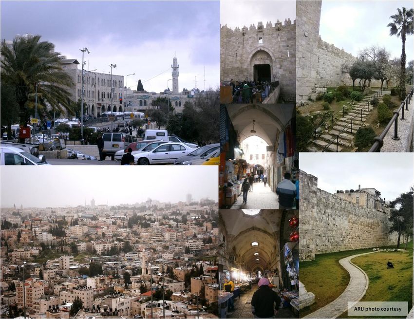
Palestinian Localities Study                                                                                  Jerusalem Governorate

                                                Table of Contents

Location and Physical Characteristics ............................................................................. 4

History ................................................................................................................................. 5
Religious and Archaeological Sites ................................................................................... 5

Population ........................................................................................................................... 6
Education ............................................................................................................................ 7

Health Status ....................................................................................................................... 9
Economic Activities ............................................................................................................ 9
Agricultural Sector........................................................................................................... 10
Institutions and Services .................................................................................................. 12

Infrastructure and Natural Resources ........................................................................... 12
Development Plans and Projects .................................................................................... 14

City Development Priorities and Needs ......................................................................... 34

References ......................................................................................................................... 35

                                                                                                                                         3
Palestinian Localities Study Jerusalem Governorate
Jerusalem ‘Old City’ Profile
Location and physical characteristics
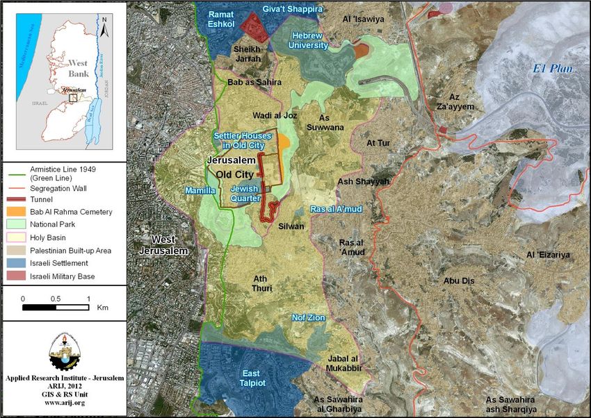
Jerusalem ‘Old City’ is a Palestinian city and the only city in Jerusalem Governorate. It is bordered by
Az Za’ayyem, El ‘Eizariya and Abu Dis territories to the east, ‘Isawiya and Shu’fat to the north,
Western Jerusalem to the west, and Jabal al Mukabbir and Silwan & Ath Thuri to the south (ARIJ-GIS
Unit, 2012) (see map 1).
Map 1: Jerusalem ‘Old City’ location and borders
Source: ARIJ - GIS Unit, 2012
Jerusalem ‘Old City’ is located at an altitude of 745m above sea level with a mean annual rainfall of
422.3mm. The average annual temperature is 17oC and the average annual humidity is approximately
60% (ARIJ-GIS Unit, 2012).
Jerusalem ‘Old City’ has several committees, including the Magistrate Clan Committee which is
currently administrated by 7 members. There is also a youth committee in each neighborhood of the city,
4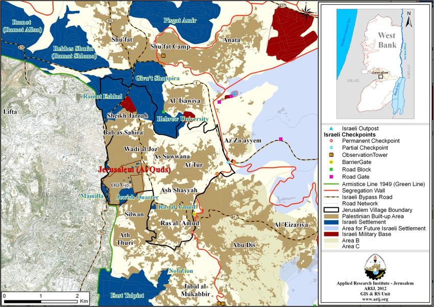
Palestinian Localities Study                                                                  Jerusalem Governorate

each of which is administrated by 7 members, but none of which owns a permanent headquarters, as
they meet in active institution headquarters in Jerusalem city (The African Community Society, 2012).

Jerusalem ‘Old City’ also contains four neighborhoods: the Islamic, Christian, Armenian and Jewish
quarters. It also includes some localities, namely Ash Sheikh Jarrah, Wadi al Jozz, As Sawwanah, At
Tur, Ras al ’Amood, Bab as Sahira and At-Tur, Mount of Olives (The African Community Society,
2012).

All services are provided by the Israeli Municipality of Jerusalem (The African Community Society,
2012).

History
Jerusalem ‘Old City’ is the largest city in historic Palestine in terms of area, population and economic
and religious importance. Jerusalem is known by other names, including Beit al Maqdis, Al Quds ash
Sharif, and ‘Ola al Qiblatain. The earliest recorded name of Jerusalem city is Or Salem, which appears
in the Tal al ‘Amarna Egyptian letters and means ‘foundations of Salem’. Salem or Shalem is the
Canaanite god who protects the city. Jerusalem has also been known as the City of Peace (‘salam’); this
name appears twice in ancient Egyptian documents from 2000 BC and 1330 BC. The city then became
known as ‘Jebus’ after the Jebusites, descendants of the Canaanites, who built the city’s castle.
Historical sources have also mentioned the Jebusite king Melchizedek, referring to him as the original
builder of Jebus or Jerusalem. Melchizedek was known as King of Peace, hence the city’s name, and it
may have been Melchizedek who named the city ‘Or Salem’ (City of Salem).1

The city was established over 5000 years ago, and its current residents are descended from residents of
many different nationalities, including Turkish, Indian, Moroccan, Syrian and many others (The African
Community Society, 2012) (see photo 1 ofJerusalem ‘Old City’).

Religious and archaeological sites
There are 12 mosques and 10 churches in the city and numerous sites of archaeological interest,
including Al Aqsa Mosque, Dome of the Rock, Ottoman fountains (water sources), the Church of the
Resurrection, hospices, Roman pools, Islamic and Turkish water wells (approximately 63 wells), and old
markets. The ancient markets include Khan az Zeit, Khan al Attarin (spice dealers), the tanning market,
and Al Attarin market. There are also 3 Turkish baths, the Via Dolorosa, Church of Mary Magdalene,
Jaffa Gate, Herod's Gate, Lions Gate, the tomb of Mary, Montefiore mill, Damascus Gate, the castle
tower and the Wailing Wall (The African Community Society, 2012).

      1
  •    History of old Jerusalem during the Arab Canaanite period: 1800-1000 BC.
  •   The Jerusalem Case - Dr. Abdel Tawab Mustafa, a series of Islamic issues, September 2006, No.139, the Supreme
      Council for Islamic Affairs, Egypt.
  •   Freedman, David Noel (2000-01-01). Eerdmans Dictionary of the Bible. Wm B. Eerdmans Publishing. pp. 694–95.
  •   G. Johannes Botterweck, Helmer Ringgren (eds.) Theological Dictionary of the Old Testament, (tr.David E.Green)
      William B.Eerdmann, Grand Rapids Michigan, Cambridge, UK 1990, Vol. VI, p.348.

                                                                                                                       5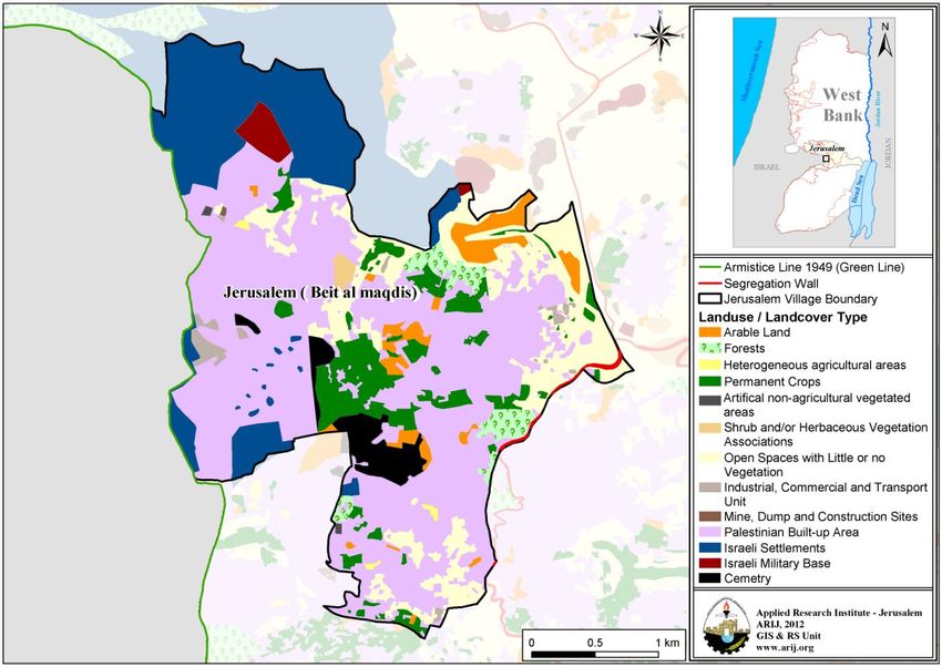
Palestinian Localities Study                                                      Jerusalem Governorate

                                      Photo 1: Jerusalem ‘Old City’

Population
Unfortunately, no census has been conducted by the Palestinian Central Bureau of Statistics (PCBS) to
ascertain the population and housing figures in Jerusalem ‘Old City’, however, according to the Israeli
Central Bureau of Statistics, the city’s population reached 119,349 in 2011 (The Jerusalem Institute for
Israel Studies, 2012).

Immigration

The field survey conducted by ARIJ team showed that around 3,000 people have left the city since the
Al Aqsa (Second) Intifada in 2000 (The African Community Society, 2012).

60 houses have been confiscated during the last 10 years (The African Community Society, 2012).

                                                                                                      6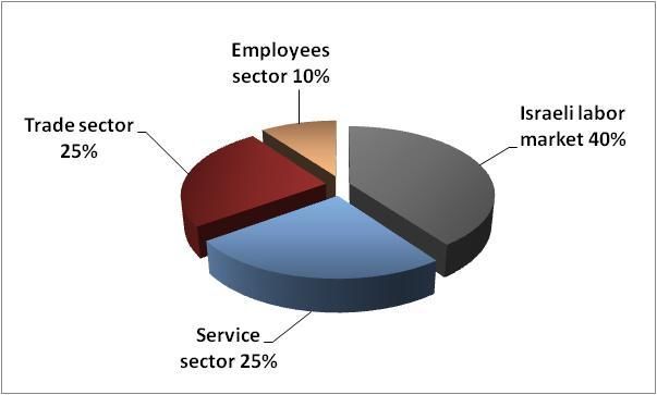
Palestinian Localities Study                                                                 Jerusalem Governorate

Education
There are 16 governmental schools in the city run by the Palestinian Ministry of Education and Higher
Education, 25 private schools and one school run by UNRWA (Directorate of Education – Jerusalem,
2011), in addition to 17 schools run by Jerusalem Municipality (The African Community Society, 2012)
(see Table 1).

          Table 1: Schools in Jerusalem ‘Old City’ by name, stage, sex and supervising authority, 2010/2011

                           School name                             Supervising authority             Sex
      The Orphans’ Islamic High School                                   Government                 Male
      The Orphans’ Islamic Elementary School (A)                         Government                 Male
      The Orphans’ Elementary School (C)                                 Government                 Male
      The Orphans’ Islamic Elementary School (D)                         Government                 Male
      An Nahda Islamic Elementary School (A)                             Government                Female
      Ar Rawda Modern Islamic School                                     Government                Female
      The Orphans’ Islamic Elementary School (B)                         Government                 Male
      Al Dawha Elementary School                                         Government                Female
      The Muslim Young Females’ High School                              Government                Female
      Al Fatat al Laji'a Elementary School (C)                           Government                Female
      Dar al Fatat al Laji'a High School                                 Government                Female
      An Nahda Islamic Elementary School (B)                             Government                Mixed
      Al Fatat al Laji'a Elementary School (D)                           Government                Mixed
      Al Fatat al Laji'a Elementary School (A)                           Government                Female
      Al Fatat al Laji'a ash Shamila High School                         Government                Female
      An Nahda (C) Co-educational School                                 Government                Mixed
      Dar al Awlad School – Jerusalem                                      Private                  Male
      Ash Shar’iya Girls’ High School                                      Private                 Female
      Al Aqsa ash Shar’iya Boys’ High School                               Private                  Male
      Al Haram ash Sharif School                                           Private                 Mixed
      The Abrahamic College School                                         Private                 Mixed
      Al Huda School                                                       Private                 Mixed
      Siraj al Quds School                                                 Private                 Mixed
      Al Antwaniya Coptic College School                                   Private                 Mixed
      The Bishop High School                                               Private                 Mixed
      Schmidt College Girls’ School                                        Private                 Female
      Mar Mitri High School                                                Private                 Mixed
      Lady of Pillar School – Jerusalem                                    Private                 Female
      Terra Sancta Boys’ High School                                       Private                 Mixed
      Princess Basma Foundation Co-educated School                         Private                 Mixed
      Terra Sancta - St. Joseph Sisters Girls’ High                        Private                 Female
      School - Jerusalem
      Frères High School - Jerusalem                                        Private                 Mixed
      The Martyr Demiana Coptic College Girls’ School                       Private                 Mixed
      Az Zuhoor School & Kindergarten                                       Private                 Mixed

                                                                                                                 7
Palestinian Localities Study Jerusalem Governorate
Mount of Olives Children School & Kindergarten Private Mixed
House of the Arab Child High School Private Female
Az Zahra’ Model School Private Mixed
Nadi al Ansari School Private Mixed
Al Hidaya School Private Mixed
Noor al Quds School Private Mixed
Al Firdaws (Paradise) School Private Mixed
Al Quds Boys’ Elementary School UNRWA Male
Emilison Co-educational Preparatory School Jerusalem Municipality Mixed
At Tur Girls’ Preparatory School Jerusalem Municipality Female
At Tura Girls’ Primary School Jerusalem Municipality Female
Ras al ‘Amood Boys’ Preparatory School Jerusalem Municipality Male
Ras al ‘Amood ash Shamila Girls’ School Jerusalem Municipality Female
Khalil as Sakakini Girls’ Preparatory School Jerusalem Municipality Female
Al Mailawiya Girls’ Primary School Jerusalem Municipality Female
Al ‘Omariya Boys’ Primary School Jerusalem Municipality Male
Ar Rashidiya Boys’ High School Jerusalem Municipality Male
Al Ma’muniya Girls’ High School Jerusalem Municipality Female
Abd Allah Ben al Hussein Boys’ High School Jerusalem Municipality Male
Abd Allah Ben al Hussein Girls’ High School Jerusalem Municipality Female
At Tur Girls’ Preparatory School Jerusalem Municipality Female
The Boys’ (B) Primary School Jerusalem Municipality Male
At Tur Boys’ Primary (A) School Jerusalem Municipality Male
At Tur ash Shamila Boys’ School Jerusalem Municipality Male
Ibn Khaldoon ash Shamila Boys’ School Jerusalem Municipality Male
Source: The African Community Society, 2012 & Directorate of Education – Jerusalem, 2011
There are 27,381 students and 994 classes. It should be noted here that the average number of students
per class is approximately 28 (Directorate of Education in Jerusalem, 2011).
There are 18 local kindergartens run by different bodies, attended by 1,761 children in total in 2012.
Table 2 shows these kindergartens according to their names and supervising authority (Directorate of
Education in Jerusalem, 2011).
Table 2: Kindergartens in Jerusalem ‘Old City’ by name and supervising authority
Kindergarten name No. of children Supervising authority
Al Hidaya Kindergarten 124 Private
Mount of Olives Children Kindergarten 332 Private
Al Aqsa Islamic Kindergarten 65 Islamic Civil
Az Zuhoor Kindergarten 65 Private
The Abrahamic College Kindergarten – Jeruslem 111 Islamic Civil
Al Huda Kindergarten 148 Islamic Civil
Bara’em Wadi al Jozz Kindergarten 51 Private
Terra Sancta Boys’ Kindergarten 31 Christian Civil
House of the Arab Child Kindergarten - Jerusalem 144 Private
8Palestinian Localities Study Jerusalem Governorate
St. Joseph Sisters Kindergarten 52 Christian Civil
Lady of Pillar Kindegragten - Jerusalem 25 Christian Civil
Schmidt College Kindergarten 58 Christian Civil
Princess Basma Foundation Kindegarten 134 Christian Civil
Mar Mitri Kindergarten 34 Christian Civil
Freres School Kindergarten 141 Christian Civil
The Bishop School Kindergarten 68 Christian Civil
Nadi al Ansar Jerusalem Kindergarten 63 Private
Noor al Quds Kindergarten 118 Private
Source: Directorate of Education in Jerusalem, 2011
The educational sector in Jerusalem ‘Old City’ faces some obstacles, primarily:
1. The residents are not allowed to construct new schools.
2. The overcrowded classrooms.
3. The lack of playgrounds for students.
4. The lack of land for the construction or expansion of schools.
(The African Community Society, 2012)
Health status
There are various health centers available in Jerusalem ‘Old City’. These include 20 health centers run
by the Israeli National Insurance (Patients’ Fund), another 3 health centers run by an NGO, 6 private
dental clinics, 2 pharmacies, an ambulance owned by the Palestinian Red Crescent Society and an
ambulance owned by the David Star Society (The African Community Society, 2012).
However, the health sector in Jerusalem ‘Old City’ faces some obstacles, primarily:
1. The lack of space for patients in hospitals.
2. Discrimination between Arab and Jewish patients.
(The African Community Society, 2012)
Economic activities
The economy in Jerusalem ‘Old City’ is dependent on several economic sectors, mainly the Israeli labor
market, which absorbs 40% of the workforce (The African Community Society, 2012) (see figure 1).
A field survey conducted by ARIJ in 2012 showed that the distribution of labor by economic activity in
Jerusalem ‘Old City’ is as follows:
Israeli labor market (40%)
Services sector (25%)
Trade sector (25%)
Government or private employees sector (10%)
9Palestinian Localities Study Jerusalem Governorate
Figure 1: Economic activity in Jerusalem ‘the Old City’
Source: The African Community Society, 2012
In terms of commercial and industrial productions in Jerusalem ‘Old City’ there are 700 grocery stores, 12
bakeries, 40 butchers, 20 fruit and vegetable stores, 13 different services stores and 20 different professional
workshops (blacksmith, carpentry etc.) There also are two sesame tahini presses (The African Community
Society, 2012).
The unemployment rate in Jerusalem ‘Old City’ reached around 12% in 2012 and it was found that the social
groups most affected in the city as a result of Israeli restrictions and procedures are:
1. Workers in the tourism sector.
2. Workers in the trade sector.
3. Workers in industry.
(The African Community Society, 2012)
Agricultural sector
Jerusalem ‘Old City’ has a total area of around 9,108 dunums, of which 1,067 are considered ‘arable’
land and 4,498 dunums are registered as ‘residential’ (see table 3 and map 2).
Table 3: Land use and land cover in Jerusalem ‘the Old City’ in 2010 (area in dunums)
Agricultural area Area of
Area of
Built (1,067) settlements,
Total Inland Open industrial,
up Forests military
area Permanent Greenho Rangel Arable water spaces commercial &
area bases &
crops uses ands lands transport unit
Wall zone
9,108 4,498 715 1 37 315 0 215 1,269 398 1,660
Source: ARIJ – GIS Unit, 2012
11Palestinian Localities Study Jerusalem Governorate
Map 2: Land use/land cover in Jerusalem ‘the Old City’
Source: ARIJ - GIS Unit, 2012
Table 4 shows the different types of fruit trees planted in the area. The city is known for the cultivation
of olives; there are 38 dunums in the city cultivated with olive trees.
Table 4: Total area of fruit and olive trees in Jerusalem ‘the Old City’
Fruit trees Rain fed (dunums) Irrigated (dunums)
Olives 38 0
Citrus 0 0
Stone fruits 0 0
Pome fruits 0 0
Nuts 4 0
Other fruits 2 0
Total area 44 0
Source: Palestinian Ministry of Agriculture - Jerusalem, 2010
The difference between the two sets of results obtained from the Ministry of Agriculture and by ARIJ’s
GIS Unit in sizes of agricultural areas is explained by the fact that the Ministry of Agriculture and the
Palestinian Central Bureau of Statistics (2010) conducted a survey which used a definition of
11Palestinian Localities Study Jerusalem Governorate
agricultural areas based on land ownership. Therefore, the areas included in the survey were those of
actual holdings of agricultural areas instead of seasonal ones. The survey did not consider fragmented
and small seasonal cultivated areas in residential and agricultural areas. ARIJ’s survey, however,
indicated the existence of a high proportion of small and fragmented holdings (home gardens)
throughout the occupied Palestinian territories, thus accounting for the larger area of agricultural
holdings calculated by ARIJ.
The field survey conducted by ARIJ shows that 30 families in Jerusalem ‘Old City’ rear and keep birds
(pigeons) (The African Community Society, 2012), and that there are 20 beehives owned by residents in
the city (Palestinian Ministry of Agriculture - Jerusalem, 2010)
There are no agricultural roads in the city (The African Community Society, 2012).
Institutions and Services
Jerusalem ‘Old City’ has very few governmental institutions. There is a police station and a few local
institutions and associations that provide services to various sectors of society. These include (The
African Community Society, 2012):
Al Laqlaq Tower
Sons of Jerusalem Club
Sabafort Children Center
Zahret al Mada’en Society
The African Community Society
The Old City Youth Society
Saraya Center
The Arabs Catholic Group
Sons of Virgin Mary Society
The Syrian Club
The Armenian Club
Ladies of the Annunciation Society
Infrastructure and natural resources
Electricity and Telecommunication Services
Jerusalem ‘Old City’ has been connected to a public electricity network since 1967. It is served by
Jerusalem Electricity Company, which is the main source of electricity in the city. Approximately 100%
of the housing units in the city are connected to this network (The African Community Society, 2012).
12Palestinian Localities Study Jerusalem Governorate
Jerusalem ‘Old City’ is connected to a telecommunication network through the Jerusalem Municipality
and approximately 100% of the housing units within the city boundaries are connected to phone lines
(The African Community Society, 2012).
Transportation Services
There are no means of transportation in Jerusalem ‘Old City’ (The African Community Society, 2012)
Water Resources
Jerusalem ‘Old City’ is provided with water by Jihon, an Israeli company, through the public water
network established in 1967 and approximately 100% of the housing units are connected to this network
(The African Community Society, 2012).
Information about the quantity of water supplied monthly by Jihon to Jerusalem ‘Old City’ was not
available. Each cubic meter of water from the network costs between 7 to 15 NIS (The African
Community Society, 2012).
Sanitation
Jerusalem ‘Old City’ has a public sewerage network, established in 1967; almost all of the city’s
housing units (100%) use the sewage network as a major means for wastewater disposal (The African
Community Society, 2012).
Solid Waste Management
Jerusalem Municipality is the official body responsible for managing the collection and disposal of solid
waste generated by the citizens and establishments in the city. No specific fees are charged to the
population served by domestic solid waste collection and transportation services; citizens pay the
Arnona tax to Jerusalem Municipality which range from 3,000 to 10,000 NIS/ year depending on the
size of household. This tax covers all services provided by Jerusalem Municipality to the city residents,
including the collection of solid waste services (The African Community Society, 2012).
Most of the population in Jerusalem ‘Old City’ benefits from the solid waste services, whereby waste is
collected from households, institutions, shops, and public squares in plastic bags and then transferred to
130 containers, each with 1 cubic meter capacity, distributed throughout the city. Jerusalem
Municipality collects the solid waste twice a week and then transports it using a waste vehicle to El
'Eizariya dumping site, where it is usually buried and sometimes burnt (The African Community
Society, 2012).
The daily per capita rate of solid waste production in Jerusalem ‘Old City’ is 1.05kg. Thus the estimated
amount of solid waste produced per day by residents is nearly 100 tons, or 36,667 tons per year (ARIJ-
WERU, 2012).
13Palestinian Localities Study Jerusalem Governorate
Geopolitical Status of Jerusalem City
Due to its historical and religious importance, Jerusalem, as a holy city for the monotheistic religions
remains a major conflict point between Israeli Jews and Palestinian Christians and Muslims. Jerusalem
remains the disputed capital of the Palestinian Territory; it represents the main religious, commercial
and economic center for Palestinians but in 1976 has been illegally declared by Israelis as their ‘eternal
and unified’ capital city. Since the beginning of Israel’s occupation of Palestine in the twentieth century,
the city of Jerusalem has been the most prominent place for destructive Israeli military, colonial,
cultural, and religiously targeted activities. The Palestinian capital city became a target for
‘Judaization’2, isolation, colonization and ethnic cleansing with the old city of Jerusalem which contains
the holy sites of Muslims and Christians, such as Al-Aqsa Mosque and Church of the Holy Sepulcher.
The successive Israeli Governments have launched targeted attacks at Jerusalem city that aimed at
completely controlling the city and its holy sites, and expelling as many Palestinians as possible of
those living in it in order to reach the Jewish majority within the city at maximum through the
construction of Israeli settlements in and around the city, and the confiscation of Palestinian lands and
designate these lands for further settlement expansion .
Background:
Following the 1967 war, Israeli authorities declared Jerusalem city as its “eternal unified capital,” and
succeeded afterwards in altering the geographic and demographic layout of the city. Tremendous efforts
on the part of the Israelis have been made to promote their colonizing and illegal actions as a legitimate
means of democratic governance over the city. This has been achieved using a de jure policy of fluid
city boundaries. The “artificially created” Green Line, Israel’s internationally recognized 1949 border,
was deeply repressed, as Jerusalem’s boundaries became fluid and elastic to insure a Jewish superiority,
achieving the Zionist myth of; “a land without people for a people without land.” This, in turn, blurred
and gerrymandered the difference between “the political space of the state and the cultural space of the
nation” a difference hidden by the hyphenated concept of “nation-state” (Kemp, 2000).
Chronological changing of boundaries
In the period 1948-1967, Jerusalem was to remain separate under international supervision; a 'Corpus
Separatum' in the words of the United Nations (UN). In November 1947, the United Nation General
Assembly (UNGA), in its 128th plenary session, passed Resolution No. 181 which partitioned Historic
Palestine into two States, one for Jews and the other for Arabs. The Arab-Palestinians rejected the plan
as it confiscated 55.5% of what they owned from Mandate Palestine to the Jews. The Jews who only
owned 6% of the land were allocated 55.5% against 44.5% to the Arabs who had previously owned 94%
of the land of Historic Palestine. However, because of 1948 War, Israel ran on 78% of Mandate
Palestine, destroyed 419 Palestinian villages and caused the displacement of more than 900,000
Palestinian refugees (Issac et. al., 2008).
Jerusalem has drawn the world’s attention over the past forty-six years, since its occupation during
1967. Shortly after the 1967 war, the city was divided into two parts, the Jewish West Jerusalem and the
2
Judaization is a process of cultural assimilation in which a person or a demographic group acquires Jewish cultural and
religious beliefs and values.
14Palestinian Localities Study Jerusalem Governorate
occupied Arab East Jerusalem. In order to ensure Jerusalem represents Israel’s largest city, Israelis’
redrew the administrative boundaries of the Palestinians Governorates, expanding the Jerusalem
municipal boundaries from 6.5km² (including the old city) to 71 km² (ARIJ-GIS, 2012)
The new boundaries of the city were delineated for security reasons and demographic considerations; to
create a geographic integrity and demographic superiority to Jews in Jerusalem. (Shaul Efraim Cohen
1993, p. 78) points out that the placement of the new boundary line: “was determined according to
strategic-demographic policy and not according to pure planning considerations. The interest of
this policy was to include within the city ridges and sites which provided strategic control of the
city and the roads leading to it, along with large additional territories containing a minimum Arab
population.” (Cohen, 1993)
In order to accomplish this, the redrawing of Jerusalem municipal boundaries excluded the densely
populated Palestinian communities (the mythic of “land without people”) in the north, including Beit
Iksa and Beir Nabala, whereas the sparsely populated communities’ lands in the south were included
(Bethlehem and Beit Sahour)(ARIJ,2009).However, the municipal planning deliberations were of
secondary importance in setting the new boundaries.
In 2004, the Israeli Jerusalem Municipality disclosed its ‘Town Planning Scheme of 2000,” which sets
out plans until the year 2020. Accordingly, the boundary of the western part of the city is extended by
40% (i.e. 142 km2). According to the new Master Plan, more than half of the eastern part
of Jerusalem city is zoned as built-up areas and 24.4% are zoned as open “green natural” areas (ARIJ
GIS-Database, 2012).
In September 2008, a new chapter of the Israeli colonial and expansionist policies in Jerusalem city was
revealed through the announcement of ‘Jerusalem Regional Plan, 2008’, which stressed on the Jewish
dream of Jerusalem “unified” and eternal capital of the state of Israel, after it has been eradicated from
the West Bank, which in turn, eliminated the “one State” and two-states solutions (Oren Yiftachel,
2005). The Jerusalem regional plan comes 50 years after the last regional plan of Jerusalem city was
issued and was prepared and named after the British planner, Henry Kendel. The plan was also known
as “RJ4” plan (Coon, 1992). However, this plan was not finalized and was lost during the 1948 war.
Jerusalem City after 1967:
Most of the land of Jerusalem City (a total area of 9,108 dunums) is located under Jerusalem Israeli
Municipality’s control. Jerusalem Governorate was divided into two main regions: J1 area which is
located inside the borders and under the control of the Jerusalem Municipality. J1 area includes many
Palestinian Jerusalemite communities such as the communities of the Old Town and Jerusalem City
(Beit Al-Maqdis), in addition to Jerusalem city which is located in (J1) area to the north. The other
classified region is J2, which is located outside the borders and the control of Jerusalem Municipality.
This area is under the Palestinian Authority’s control within Jerusalem Governorate and includes its
eastern and western parts, whereas the central part of the Governorate remains under Israeli occupied
control. It is noted that in this report, the area of Jerusalem under discussion is the central part of East
Jerusalem which includes neighborhoods such as: the Old Town and the holy places within it including
15Palestinian Localities Study Jerusalem Governorate
Al-Aqsa Mosque and Church of the Holy Sepulcher, in addition to the neighborhoods of Ash Sheikh
Jarrah, Wadi al Joz, As Suwwana, At Tur and Ras al ‘Amud.
According to the Oslo II Interim Agreement signed between the Palestinian Liberation Organization
(PLO) and Israel on 28th September 1995, which divided the West Bank into areas “A,” “B” and “C.”
Jerusalem was not a subject to this classification, but remained as it was before this agreement; under the
control of Jerusalem Israeli Municipality. It is further noted that Israeli Occupation Authorities have
used the separation plan which is represented by the construction of the Segregation Wall to illegally
and unilaterally redraw the boundaries of Jerusalem Municipality where the Wall has separated the
whole area of J1 from Jerusalem Governorate except for Kafr ‘Aqab, Shu’fat Camp and part of Shu’fat
town, which are isolated outside of the J1 area.
Israeli Occupation Practices in Jerusalem City
Jerusalem city has been subjected to numerous Israeli confiscations for the benefit of various Israeli
targets. Confiscations have included; the construction of Israeli settlements, outposts, military bases,
military barriers and bypass roads on the city territories and its surroundings, in addition to the Israeli
segregation plan. That which follows discusses a number of major Israeli confiscations within Jerusalem
city territories:
During Israel’s occupation of the Palestinian Territory, the Israeli government confiscated 1,516 dunums
in Jerusalem city (16.6% of the total city area) to establish seven Israeli settlements surrounding the old
town from all directions. These settlements are currently inhabited by approximately 28,000 Israeli
settlers. The city has been disastrously affected by these settlements and now represents a closed canton
surrounded by settlements and the Separation Wall, from all directions. The seven Israeli settlements
which have been built on the city’s territories are: “Ramat Eshkol”, “Hebrew University” and “Giva't
Shappira (French Hill)” settlements to the north of the city, the “Jewish Quarter”, “Mamilla” and “Ras al
‘Amud (Ma’ale Hazetim)” settlements to the south of the city, in addition to the “Settlers’ Houses” in
the Old Town. The western direction of the city was totally suffocated by the “Israeli settlements of
West Jerusalem” whereas the Governorate completed the isolation ring in the eastern direction of the
city (Table 5).
Table 5: Israeli Settlements constructed on Jerusalem City lands
Year of Area confiscated from Population of
Settlement Name
construction Jerusalem City (dunums) settlers (2009)
Ramat Eshkol 1968 711 10294
Hebrew University (Har Hatzofim) 1968 413 1236
Jewish Quarter 1968 131 3094
Giva't Shappira 1968 126 9000
(French Hill)
Mamilla 1997 100 3272
Ras al ‘Amud (Ma’ale Hazetim) 1998 15 670
Settlers Houses in the Old Town -- 20 282
Total 1,516 27,848
Source: ARIJ-GIS Unit, 2012
16Palestinian Localities Study Jerusalem Governorate
Moreover, the Israeli Occupation Forces (IOF) confiscated hundreds of thousands of dunums of
Palestinian land to construct many Israeli bypass roads which are extended thousands of kilometers over
the West Bank. This has been achieved through the confiscation of agricultural and non-agricultural
lands to connect the settlements and to divide the Palestinian land in a way that strengthens Israeli
security control over them. Within Jerusalem territories, IOF have constructed Israeli bypass roads no.1,
60 and 417 on confiscated lands. It is worth mentioning that the real threat of bypass roads lies in the
buffer zone formed by the IOF along these roads, extending to approximately 75 m on the roads’ sides.
Furthermore, the Israeli Occupation Authorities confiscated additional lands from Jerusalem city to
establish two Israeli military bases on the city’s territory near “Hebrew University” and “Ramat Eshkol”
settlements. The area confiscated for this purpose is estimated at 118 dunums. These bases were
established under the pretext of protecting the Israeli settlements that were constructed on and nearby to
the city’s territory.
Israeli military presence in the city is not limited to these two military bases, as Israeli soldiers are
highly present (visible) and spread across the city in many contexts; infantry, cavalry, in vehicles and at
checkpoints. IOF are always present in all the city’s neighborhoods particularly in the Old Town and the
area surrounding Al-Aqsa Mosque, where military bands are distributed on all the internal and external
gates of the Old Town and Al-Aqsa Mosque. Resultantly, all persons wishing to enter this area are
subject to inspection. During Fridays and the Muslim Ramadan celebrations, the city witnesses intensive
military presence with soldiers preventing people from reaching Al-Aqsa Mosque for prayer. This
frequently affects Palestinians who hold the Palestinian (Green) identity in addition to Arab youths who
are regularly inspected and prevented from access to the mosque yard. The type of persons most able to
reach the mosque are the elderly and women who hold the Jerusalemite blue ID.
Jerusalem City and the Israeli Segregation Wall Plan
The construction of the Israeli Segregation Wall has had a negative impact on Jerusalem city.
According to the last amendment of the plan that was published on the webpage of the Israeli Defense
Ministry on the 30th April 2007, the Segregation Wall is isolating all the lands of Jerusalem city from the
remaining Palestinian territory in the West Bank. The isolated lands include all Palestinian built-up areas
in the city, illegal settlements and military bases constructed on the city’s land, open spaces, agricultural
areas, forests and others (Table 6).
17Palestinian Localities Study Jerusalem Governorate
Table 6: Land classification of the isolated areas to the west side of the Segregation Wall in
Jerusalem city - Jerusalem Governorate
No. Land classification Area (dunums)
1 Palestinian built-up area 4,502
2 Israeli settlements 1,516
3 Open spaces 1,260
4 Agricultural areas 1,030
5 Cemeteries 283
6 Forests 215
7 Israeli military bases 118
8 Industrial, commercial or transportation units 97
9 Shrub and/or herbaceous vegetation associations 37
10 Wall zone 27
11 Playgrounds 20
12 Construction Sites 3
Total 9,108
Source: ARIJ-GIS Unit, 2012
The Segregation Wall and the Suffering of Jerusalem City Residents
Since the outbreak of the Second Intifada in September 2000, citizens of Jerusalem city and the nearby
towns have lost their association with Palestinian cities in the West Bank, where the city of Jerusalem
along with some surrounding towns were separated from the West Bank, by the Segregation Wall.
Jerusalem citizens who hold the Jerusalemite identity (Blue ID) can enter West Bank areas through
Israeli terminals which often witness huge congestion, while being subjected to thorough inspection
from Israeli soldiers which causes restriction on Palestinians’ freedom of movement.
However, the Palestinian citizens of the West Bank who hold the Palestinian Identity (the Green
Identity) are prohibited from entering the city of Jerusalem and its surrounding towns because the
Segregation Wall is isolating these West Bankers totally from Jerusalem. This restricts such residents
from accessing services in the sectors of; health, education and socio-economic facilities. In reality this
represents a restriction to hospitals, schools and medical centers, in addition to isolation from their
places of work in Jerusalem. Those with West Bank IDs will not be able to reach the city except for
those who have special Israeli permits which are rarely given to them, and through the military
checkpoints where they precisely inspected on a daily-basis. This causes suffering for Palestinians and
difficulty in movement and interaction, and also causes the dismantling of family bonding social
interaction and dispersal of many Palestinian families, especially in cases where one of a couple holds
Palestinian identity (Green), and the other one the Jerusalemite identity (Blue).
The Segregation Wall plan shows that upon wall completion, the lands of Jerusalem City will become
isolated from neighboring Palestinian towns and villages, where the Segregation Wall along with the
settlement’s belt around Jerusalem City will isolate East Jerusalem area from the rest of the West Bank.
18Palestinian Localities Study Jerusalem Governorate
The existing Segregation Wall is surrounding the city from three directions, which makes the city
greatly affected by Israel’s colonization, occupation and settlers’ practices.
Parallel to the establishment of the Segregation Wall, the Israeli Occupation Authorities constructed a
settlement belt around Jerusalem City which aims at founding an isolation area, in addition to the
prevention of urban expansion in the Palestinian towns of Jerusalem. The Israeli Occupation Authorities
have constructed these settlements close to the urbanized areas in the Jerusalemite towns, which has led
to the increase of the total area confiscated in these towns, and minimizing the area available for future
urban expansion for the people. In addition this move has created a new reality on the city residents that
will be difficult to change.
These Israeli policies and plans particularly in Jerusalem, have led to the creation of high population
densities as a result of the lack of lands needed for urban expansion which has forced people to expand
BOTH internally and vertically. Jerusalem city and its surrounding towns are considered to have one of
the world’s highest population densities. The population density in the Palestinian neighborhoods in East
Jerusalem is about 13,500 person/ km2 compared to 9,000 person/ km2 in the settlements of East
Jerusalem and 8,300 person/ km2 in West Jerusalem.
The Dilemma of Land and Building’s Licenses in Jerusalem City
The problem of the land and building’s licenses is considered one of the most difficult problems in
Jerusalem city and in other areas of East Jerusalem. The reason for this is two-fold; the high prices of
lands and the very high cost of licenses for construction.
Jerusalem city is characterized by its strategic location in East Jerusalem and its closeness to the old city
and Al-Aqsa Mosque, which has made it an important target for Juadization and colonization in addition
to restrictions related to buildings’ licenses imposed by the IOF. Regarding the availability of lands,
Jerusalem city is lacking lands and open spaces for Palestinian urban expansion and it is suffering from
a high population density.
According to citizens of Jerusalem, land prices (price per dunum) in East Jerusalem area, most
specifically land located within the borders of the Jerusalem municipality -which is rarely available- is
relatively higher than land located outside the borders of the municipality, and are even doubled in
places closer to the city center and surrounding neighborhoods.
The Israeli Occupation Authorities have used the money as an effective instrument to buy the
Palestinian lands in Jerusalem for enormous prices and ‘Judaize’ these lands by implanting Jewish
settlers in the city. Israeli forces offer Palestinians unlimited prices for such lands and houses especially
in the city center and its neighborhoods. For anyone in Jerusalem who has a land and want to build a
house, or buy additional land, has to take authorization and permission from the Municipality of
Jerusalem which puts obstacles in the way of Palestinians who want to get a license for the building.
This is because the Israeli Authorities aim to expel Palestinians out of Jerusalem to change the
demographic situation in the city for the benefit of the Jews and to make the Palestinians in Jerusalem a
minority.
One of the main obstacles that comes in the way of obtaining a building license is that one has to prove
the ownership of the land. The Israeli Occupation Authorities require that Palestinians seeking to build a
19Palestinian Localities Study Jerusalem Governorate
house/structure, must prove their ownership of the land, which is considered a political problem related
to the occupation since 1967.
According to a report prepared by Bimkom Organization (Planners for Planning Rights), approximately
50% of the East Jerusalem lands are unregistered in the archive of ownership such as the town of Kafr
‘Aqab and the area extending from Al ‘Isawiya town in the north to Sur Bahir in the south. Additionally,
25% of the lands in East Jerusalem are in the process of survey and registration (such as Beit Hanina and
Shu’fat towns); and only 25% of the lands in East Jerusalem are officially registered and include parts of
Al Bireh, Qalandiya, Beit Hanina, Hizma and ‘Anata, Ash Sheikh Jarrah and Beit Safafa (Bimkom,
2004).
According to the testimonies of Palestinians in the city of Jerusalem, anyone from Jerusalem city who
wants to get a license for building, the licensing procedure is lengthy (sometimes lasting years) and
carries very high costs. Depending on the land area and type of building for which a permit is being
sought, the license will cost between 150,000-300,000 NIS. Because of the political problem of land
registration and ownership, the unreasonable prices of licenses, in addition to the lengthy time it takes to
secure licenses many citizens because of humanitarian needs and the natural family growth resort to
building without licenses or after rejection from the Municipality. In these cases, the Israeli Occupation
Authorities usually demolish the building and force the owner to pay the fine and even the cost of
demolition. Subsequently, the owner must submit a new application for the license with a new fee and
time procedure. On top of this, the majority of Palestinian people within Jerusalem are living in difficult
conditions because of high poverty rates, which is a consequence of the Israeli Occupation closures
which restricts the movement of the Palestinians, thus preventing them from reaching work which also
increases the unemployment rate in the occupied territory. These Israeli restrictions and harassments
against the Palestinians in Jerusalem, along with the problems of housing, inflation, lack of lands and
jobs, force many Jerusalemites to migrate outside the borders of the Municipality towards the West
Bank or even outside the country to find an improvement humanitarian situation. This forced migration
of Jerusalemites and Palestinians is the ultimate goal of the Israeli policies and practices in the occupied
territory.
According to the ‘Civic Coalition for Defending Palestinian Rights’ in Jerusalem, (CCDPRJ, 2009),, the
Israeli Authorities adopted many policies that aim at enacting pressure on Jerusalemites to leave the city
of Jerusalem; for example, in the case of the demographic status and urban growth in Jerusalem, the area
that is allocated for the development of Palestinian neighborhoods in East Jerusalem and lies under the
jurisdiction of the Jerusalem Municipality is estimated at approximately 9,200 dunums which represents
only 13% of the total area of East Jerusalem; whereas the remaining area (of East Jerusalem and under
the jurisdiction of the Jerusalem Municipality) is classified as Israeli settlements, green areas -which are
off use to the Palestinian urban growth-, public buildings, roads and others. Furthermore, the Israeli
Authorities often don’t prepare the needed Master Plans for the Palestinian neighborhoods in East
Jerusalem which are necessary for the urban planning process. In cases when the Israeli Authorities
prepare master plans for Palestinian neighborhoods in East Jerusalem, Israeli Authorities usually put
restrictions and give limited percentages of areas designated for Palestinian urban expansion which are
below the needed percentages for natural urban growth, which is between 25% and 75%. If one
compares these percentages with the percentage of lands used for Israeli settlements, it is found that
urban growth varies between 75%-120%.
21Palestinian Localities Study Jerusalem Governorate
Israeli Escalation in Jerusalem Housing Demolitions
During the past years, Israeli Occupation Authorities have escalated their attacks against the houses of
Palestinians living in Jerusalem through targeting them with demolitions under the pretext of
“unlicensed construction”. An estimation of the UN Office for the Coordination of Humanitarian Affairs
(UN-OCHA) shows that since 1967, the Israeli Occupation has demolished approx. 2,000 houses and
thousands of other constructions in East Jerusalem (ICAHD, 2011). According to Al Maqdese
Organization for Society Development, approximately 1,059 houses and constructions were demolished
in East Jerusalem between the years 2000 and 2011, which resulted in the displacement of 4,865
Palestinians from Jerusalem, of whom 1,290 were women and 2,537 were children (Al Maqdese 2012).
Regarding demolitions in Jerusalem city during 2011, Al Maqdese Organization further noted that the
past year has witnessed the demolition of 46 constructions in East Jerusalem, 21 of which were in the
city center, including 9 residential constructions. This demolition of these residential constructions has
led to the displacement of 37 Palestinians, of whom 17 were children (Al Maqdese 2012).
These Israeli assaults against the Palestinians of Jerusalem aim to punish them and force them to leave
the city and its surrounding towns. It is further noted that there are hundreds of houses under threat of
demolition in Jerusalem city under the pretext of “unlicensed construction”. These claims are made
despite the fact that the residents are fulfilling the needed procedures for the license. In the majority of
cases, the Jerusalem Municipality procrastinates in granting the license and finally they refuse the
request under non-justified pretexts.
The Municipal Tax (‘Arnona’) negatively affects the living status and economic
situation of Palestinians in Jerusalem
The Municipal tax, named in Hebrew as “Arnona” is imposed by the Jerusalem Municipality on the
holders of buildings and lands in Jerusalem. This tax is considered one of the greatest burdens faced by
Palestinian residents of the city. The Israeli Authorities use this tax as an instrument to put pressure on
Palestinians to force them to leave the city. The Palestinians in East Jerusalem are exposed to unfair tax
system because they are required to pay the same rates of Arnona tax as the Israelis whose salaries are
almost six to eight times higher than that of the Palestinians. Additionally, there is a discrepancy in
spending the money collected from the Arnona Tax between West and East Jerusalem; while East
Jerusalem suffers from inadequate and insufficient infrastructure and sewage system, West Jerusalem is being
allocated huge municipal budgets for infrastructure development and is well cared for and is far more
opulent than East Jerusalem, (Electronic Intifada, 2009).
The “Arnona” tax which is imposed on Jerusalemites is calculated based on a criteria, which takes in
consideration the classification of the area and the land-use classification of the Jerusalem Master Plan
(residential areas, commercial, industrial, agricultural, public buildings, parking... etc.). They
additionally take in consideration the zone type, the type of use and the area of building or land
(Jerusalem Municipality, 2012). Regarding the residential areas they classify these into four categories
(A, B, C and D), and based on this zoning, along with the area of building, they determine and calculate
the amount of tax that must be paid for the municipality or example, the tax tariff in the residential areas
varies in the four zones between 35-98 NIS/m2 which is equivalent to approximately 10-25 US$/m2.
This means that a small house (apartment) with an area of 100-150 m2 will cost his owner 3,000-10,000
21Palestinian Localities Study Jerusalem Governorate
NIS a year. This is equivalent to approximately 800-3,000 US$. For commercial shops, the tax imposed
by the Municipality forces the merchants to increase prices. The tax tariff for the commercial shops
varies between 309-319 NIS/m2 depending on the area of the shop which is equivalent to approximately
80 US$/m2. In addition to the taxation on the residential and commercial areas, the Municipality
imposes taxes on worship places, agricultural areas, schools, kindergartens, elderly homes and others.
In terms of economic impact the segregation plan which has focused on the isolation of Jerusalem city
from the Palestinian Territory had a huge negative impact on the economic situation of the Palestinians
living in Jerusalem in general and on the commercial sector particularly, which has also suffered from
global recession. Much of the trade in Jerusalem is largely dependent on the Palestinian visitors of the
Holy City from the West Bank, Gaza Strip and the Palestinians from the occupied land in 1948, but
Israeli closure of the city has negatively affected the economic situation of the city and its residents.
Despite these difficult situations, the Occupation Authorities impose taxes without taking into
consideration the situation of the Jerusalemites, who represent the poorer class in the Holy City.
Moreover, the Municipality by the beginning of last year (2012) decided to increase the “Arnona” by
approximately 3%, which increases the burden on the Palestinians of Jerusalem.
It is further noted that in the case of Jerusalem, the Palestinians are forced to pay these taxes in order to
preserve their presence in the city without receiving a decent level of Municipal services. The planning
process in the Municipality of Jerusalem focuses on the political-demographic dimension that aims to
juadize of the city more than planning for the purposes of prosperity and well-being of its citizens.
Furthermore, the Palestinian neighborhoods and communities in Jerusalem are deliberately neglected in
the different services provision. For instance, the municipality rarely makes the needed maintenance for
the infrastructure of the Arab neighborhoods, including; roads, water and waste water networks, solid
wastes and others. The most obvious problem that the people of Jerusalem suffer is the lack of cleaning
service and the accumulation of solid wastes despite their commitment in paying the taxes for the
Municipality. This can be easily understood if we compare the situation of the Palestinians in Jerusalem
with the situation of the illegal settlers living in the city who get all the facilities and services in order to
stay in the Holy City, while Palestinians livE in poor conditions and lack services and rights that they
should receive in return for paying the Arnona tax.
Targeting Al-Aqsa Mosque:
Al-Aqsa Mosque -which represents one of the most important holy sites for Arabs and Muslims, is
considered the ultimate goal for the Zionist Colonial Program in Jerusalem as believed by The leaders
and founders of Zionism that Judaizing of Jerusalem city and Al Aqsa Mosque would not be fulfilled
unless Islamic and Christian sanctities of Jerusalem city are devastated to build the Solomon Temple at
the site of Al-Aqsa mosque. This was represented in the Father of modern Zionism movement speech,
Theodor Herzl, in the first meeting of the Zionist Congress in the Swiss city of Basle in 1897 who said,
“The moment we occupy the city of Al-Quds, if I will be alive and I be able to do something, I will not
hesitate a single moment to destroy whatever is not sacred for the Jews in Quds which has taken shape
during long years.”
The Israeli plans to control the city of Jerusalem started with the establishment of a set of Israeli
settlements, settlements’ outposts and military bases in and around the city of Jerusalem to obstruct the
22Palestinian Localities Study Jerusalem Governorate
development of the Palestinian communities in the city. The settlements, outposts and military bases
were also linked together and with settlements outside the city of Jerusalem and those inside Israel,
through the construction of bypass roads. The Israeli plans further targeted the city to segregate it from
its Palestinian environs through the erection of checkpoints, terminals and later by the construction of
the Israeli Segregation Wall which aimed at consolidating the control over the city and ensuring its
segregation from the rest of the West Bank Governorates This in turn, reinforced the Israeli ethnic
cleansing plans in the city which was and is still represented by the demolition of Palestinian houses,
harassments, imposing taxes on Palestinians three times higher than taxes imposed on Israelis living in
the city, building prohibition, denying Palestinians building licenses, freezing land registration
procedures, Israeli military presence in the city and around Al Aqsa Mosque, excavations under Al Aqsa
Mosque, among other ways of targeting the Palestinians of Jerusalem. All the mentioned violations have
the target of suffocating Al-Aqsa Mosque, where the extreme Jewish organizations (The Western Wall
Heritage Foundation as one example) are trying to demolish the Holy Mosque to build a “The Jewish
Temple” on its location.
The IOF impose its military and security control over the Mosque through an intensive military presence
which controls all gates leading to the Old city and Al-Aqsa Mosque. Furthermore, the Israeli Antiques
Authority along with the Municipality of Jerusalem and in cooperation with extreme Jewish
organizations (such as Ateret Cohanim and El Ad organizations) have worked hard on digging a large
network of tunnels underneath Al-Aqsa Mosque in the search for the “ruins of the Jewish temple.” In
addition, they have established Jewish museums and three-dimensional models on the land of Al-Aqsa
that simulate the “Talmudic Jerusalem” and the “Jewish Temple”.
The IOF, and after many years of conducting excavations underneath Al-Aqsa Mosque (since 2005),
have weakened the foundations of the mosque as it has become vulnerable to demolition due to natural
causes such as earthquakes or because of Israeli artificial quakes, as many official Palestinians and Arab
institutions warned. According to Al-Aqsa Foundation for Waqf and Heritage, the network of tunnels
under Al-Aqsa Mosque stretch from the city of Silwan in the south, passing beneath Al Aqsa Mosque
and its environs to the north of the Old Town. There are also tunnels linking the eastern part of the Old
Town of Jerusalem with its western part, where the total length of this network of tunnels may reach
approximately 1,600 meters, (JCSER2011)
Targeting Bab al Maghariba Neighborhood:
The name of this neighborhood refers to its inhabitants who came from Morocco (Moroccan/
Maghariba) after the re-capture of Jerusalem by Salah ed Din al ‘Ayyubi. This neighborhood has been
subjected to Israeli demolition in 1967 where 135 archaeological buildings and houses built on an area
of 45 dunums of land were demolished. The Israeli occupation confiscated this area and established the
Jewish quarter colony which includes Al Buraq Wall Square, Jewish Synagogues and settlers houses.
This neighborhood is considered one of the main important targeted locations within the Old Town by
Israeli forces and settlers because of its strategic location adjacent to Al-Aqsa Mosque from the western
side near Al Buraq Wall which has been occupied by Israelis and later renamed “The Wailing Wall.”
Additionally, many Jewish organizations sought the control of the Wailing Wall and its square claiming
that it represents the western wall of their “Jewish Temple” which they are seeking to establish on the
location of Al-Aqsa Mosque. Throughout history, Israel has used this neighborhood as a passage gate to
23You can also read