WITH STEVE LANORE, CBM SEP 5, 2019 - MEGA-DISASTER FOR THE BAHAMAS, "RATHER MODERATE" FOR THE CAROLINAS - CRU ...
←
→
Page content transcription
If your browser does not render page correctly, please read the page content below
With Steve LaNore, CBM
                             Sep 5, 2019

Mega-Disaster for the Bahamas, “Rather Moderate” for the Carolinas

 The eye of Category 5 Hurricane “Dorian” over Grand Bahama Island on Labor day 2019 / NOAA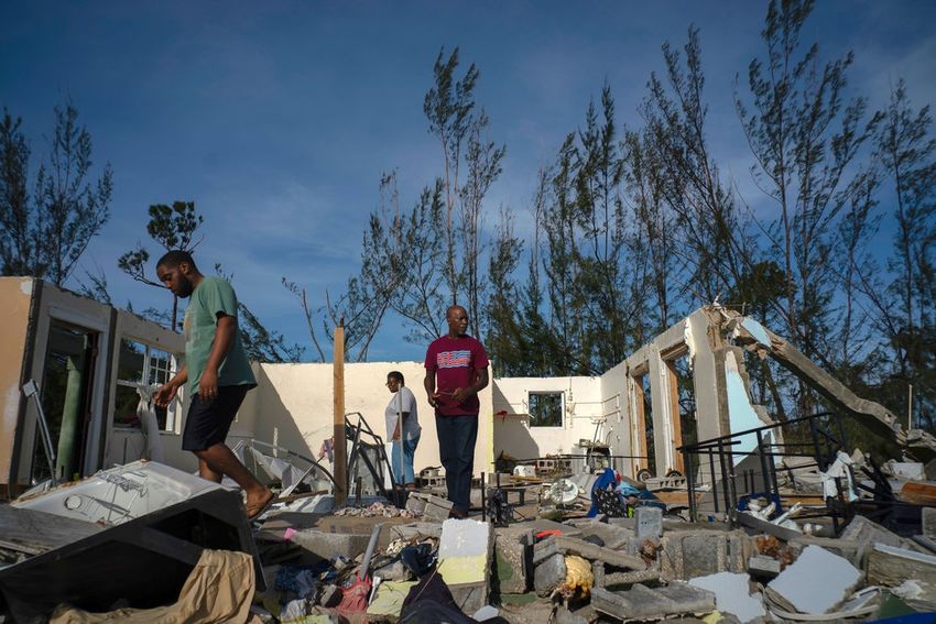
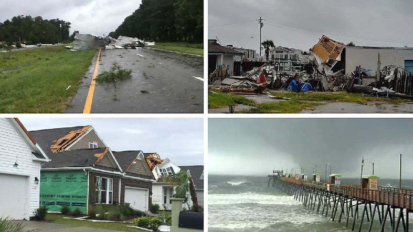
The Northern Bahamas laid waste, the death count for the island nation (at press time) 23 persons,
and likely to rise. At least $50 billion in damage, probably more, tough to say this early; at least
70,000 Bahamians “in dire need of help”- tragedy on an epic scale.

               Damage comparison in this Freeport Neighborhood/ New York Times

Freeport resident George Bolter and his parents sort through the rubble / Ramon Espinosa /AP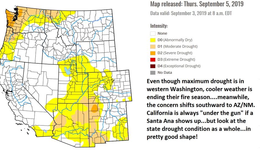
Meanwhile, less than 100 miles away, Florida woke up virtually unscathed. As the storm whirled its
    way northward there was considerable coastal flooding in South Carolina and at least three small
    tornadoes there. Flash flooding, storm surge issues and more than a dozen EF0 and EF1 tornadoes
    raked eastern NC. Some did produce a fair amount of damage, but overall the property losses…and
    human cost…were far below what Florence did last year.

This “wedge” waterspout was one of a half-dozen twisters than spun up within one spiral band as Dorian
                            grazed North Carolina on Sep 5 / WRAL-TV

              Tornado damage in Emerald Isle, NC / Spectrum News North Carolina staff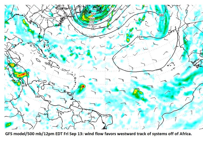
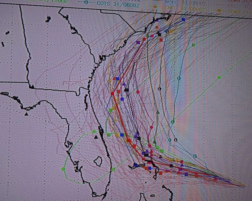
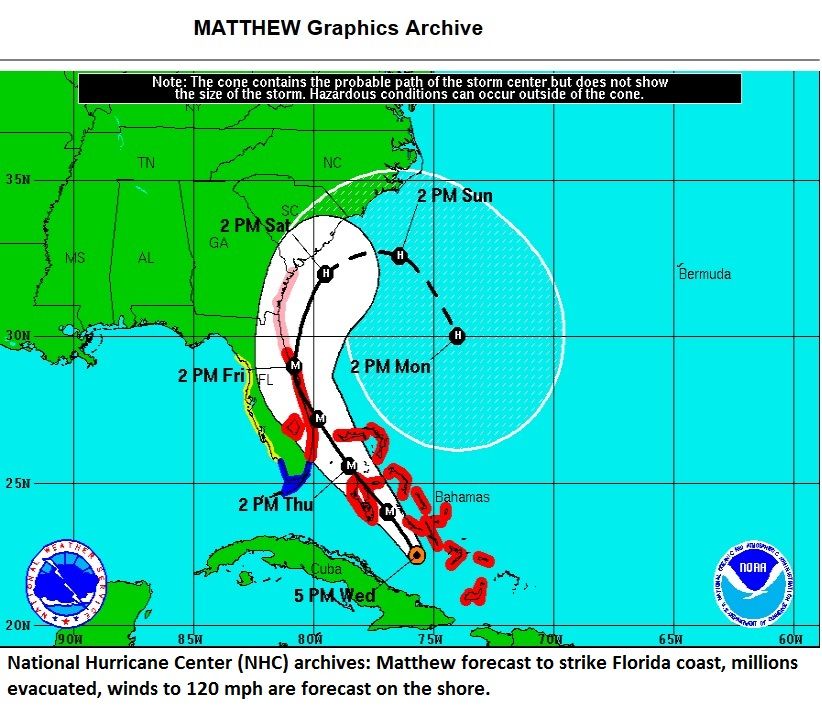
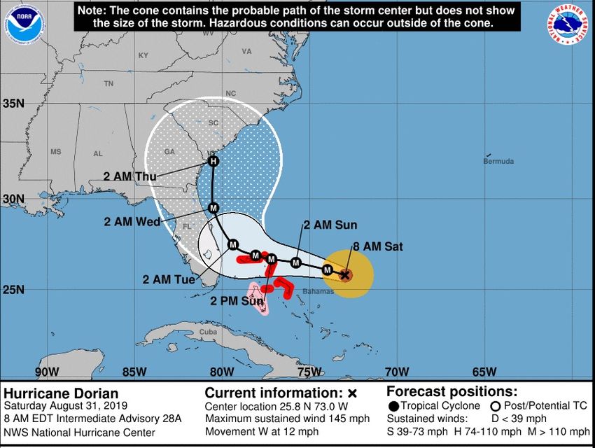
So while “Dorian” will probably rack up a few billion in U.S. (and Canadian) losses, it’s safe to say
the whole event wound up being a great example of a razor-thin “scraping” by, for sure. Dorian
tracked in a similar way to Matthew just three years ago, and with similar forecast frustration. Let’s
take a look at how this played into our near-miss.

You might recall that Matthew in 2016 was somewhat of a “bust” for Florida forecasters –
remaining less than 30 miles offshore and keeping the bulk of the damaging wind out to sea. In
both cases, fickle steering currents made the forecast unusually difficult. Here’s the forecast path
of Matthew two days before it was to hit Florida:

:

Matthew brought devastation to Nassau, the most populous part of the Bahamas just three years
ago with winds to 140 mph. It also hammered Freeport with gusts to 121 mph. Two days later, the
forecast path was adjusted by the NHC, just a few dozen miles to the east, but as with Dorian three
years later, that made a HUGE difference:
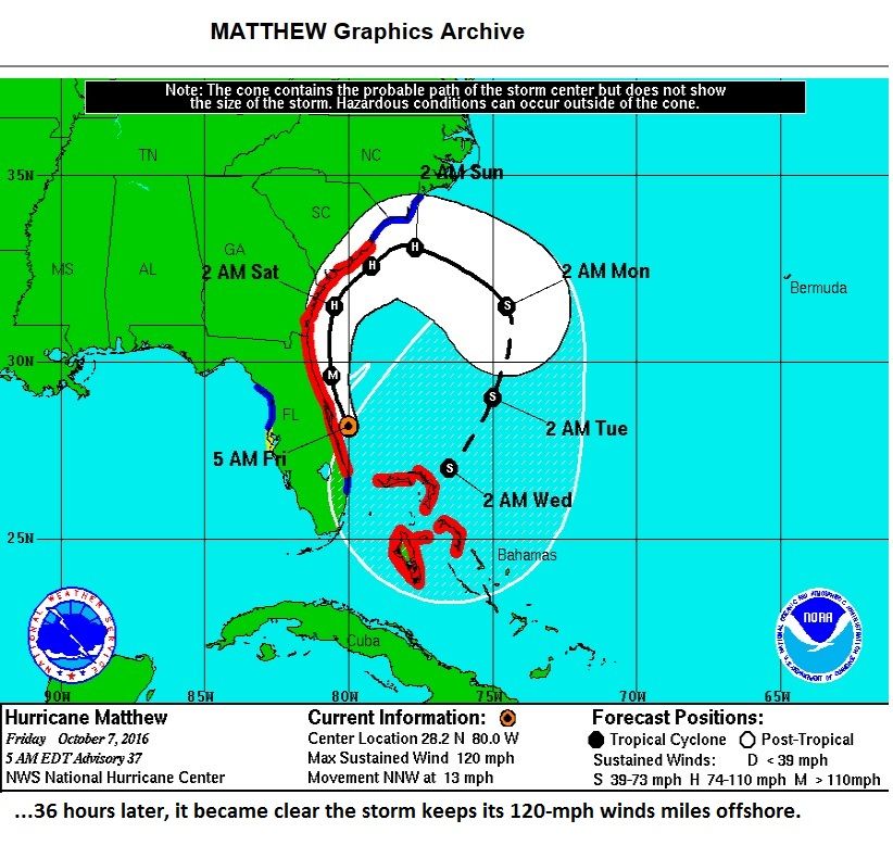
This radar “grab” from Matthew’s passing tells the story up close and windy:

Hurricane “Matthew” as it passes to the east of Melbourne (“KMLB” on the map), its eye just offshore; that
made a big difference in the damage it produced, turning a potential catastrophe into just a moderate
event. Like Dorian, it was expected to make a Florida landfall but did not, although it got much closer to the
coast than did our recent hurricane. NOAA image, about 9 a.m. EDT October 7, 2016

Now Dorian: as with Matthew, there was little indication in any of the models that it might recurve and
miss the Florida coast, only three of 20 models showed it missing a Sunshine State landfall on this August
30 run:
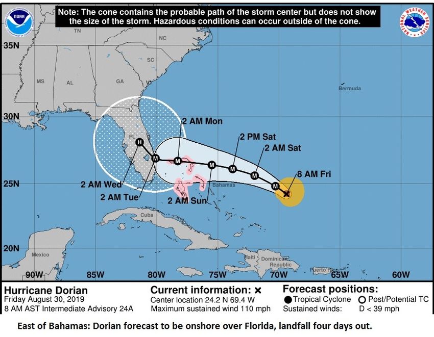
And the NHC agreed:

But, just 24 hours later the game changed drastically.
Model spread on the morning of Aug 31 – big deviation kicks in.

And so did the NHC’s forecast (below).
Two things to note about hurricane forecasts:
1) The computer models detected a subtle change in the mathematics as an upper trough approached.
   This feature came in stronger than expected, and when something like that happens, it creates a
   domino effect and everything downstream is also altered. That’s meteorology and while it’s
   frustrating, a super-tight forecast like Dorian’s is definitely impacted.
2) The actual course adjustment in miles was not great, about 100; it just so happened that took the
   hurricane track from affecting millions to offshore where its impacts were far less.

      Hopefully, this little “hurricane helper” illustrates the importance of NOT focusing on a single point,
      the “M” or the “H” on the map; that is merely the center or a whirling mass of chaos 50 to 100
      miles either side of that. The “fan” around the track line shows the potential error on the forecast,
      that’s a better tool for figuring where the trouble spots might be.

      The NHC says that a typical 5-day error in the track is about 200 miles. Dorian was well within that,
      but it still left a lot adjusters looking for work and insurance companies thanking the heavens!

      4-Way Tie for the #2 Spot
      Let’s talk numbers. Dorian was the strongest hurricane on record to hit the northwestern Bahamas
      as a Category 5 storm (winds 156 mph or greater) on the five-step Saffir-Simpson Wind Scale, its
      maximum winds reached 185 mph. Thus puts it in a 4-way tie for 2nd “strongest” on record in the
      Atlantic Basin, which includes the Atlantic, Caribbean Sea and the Gulf of Mexico.

      The other notables in the pack include 1988’s Hurricane Gilbert, Wilma in October of 2005, and the
      unnamed 1935 Labor Day Hurricane, which hit southern Florida. In the Number One spot?
      Hurricane Allen - with 190 mph winds clocked in August 1980; it struck south Texas but weakened
      to a Cat 3 before landfall.

      Beyond Dorian: Plenty of Danger Left
      Hurricane season historically peaks the second week of September, but as the graph shows, it
      remains very active through mid to late October.

  Tropical cyclones through the season per 100 years. Note the peak is in mid-September but October sees more
                                    hurricanes, typically, than August / NOAA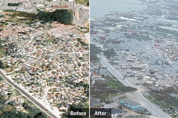
In fact, weather records over the past 15 years show seven major hurricanes, Cat 3 or greater, striking the
United States after September 15:

2018: Florence, Michael
2016: Matthew
2012: Sandy
2005: Rita, Wilma
2004: Ivan

That’s an average of one major hurricane striking the U.S. after September 15 every other year. The
season is far from over!

New areas of Concern
As of press time (Sep 5), a new area of interest was emerging off of the coast of Africa:

This is quite typical for September, the peak of the “Cape Verde Hurricane” that evolves in the eastern
Atlantic. The NHC says there’s a 10% short-range chance, shown here, but also a 50% five-day chance this
one (inside the red oval above) will form into a tropical system by Sep 10. Another one to watch!
And….it’s going to be moving toward the Caribbean and western Atlantic thanks to strong high pressure
to its north:

Florida is definitely not out of the woods; if this system develops it will likely get into the western Atlantic
or Caribbean due to its lower latitude, basically “sneaking” under the trough (inside yellow rectangle)
seen at the top of the page.

Tropical Take-Aways
So, here’s what we can use from all of this to help us in planning:

1) Hurricane forecasts have gotten quite accurate; we saw this with Harvey and Irma in 2017, Florence
   and Michael last year. Then there’s partial misses like “Barry” back in July; it moved exactly as forecast
   but fortunately did not produce the flooding we feared. And Dorian, off by only 100 miles, on paper a
   good forecast, but not a lot of help to adjusters deciding whether to drive or fly. That’s just the nature
   of the beast – so the good news is that MOST of the time the hurricane forecast will be good out two
   or three days, but be sure and check every day for trends as things can and do change!

2) We can often get a “heads up” more than a week out on potential systems and NHC outlooks like the
   one shown above are definitely worth your time. The NHC website is www.nhc.noaa.gov

   Not only does their website have the latest outlooks and hurricane forecasts, you can scan the
   archives dating back more than 20 years for tracks, dates and times of previous storms for research.
   Check it out under the “archives” tab.
A rather “friendly” fire season…
This year has turned out to be one of the tamest in a long time for fires in the Contiguous United States.

This year’s wildfires consumed 50% less acreage than last year, and more than half of the total was
confined to drought-stricken Alaska. Overall it’s the calmest fire season in five years.

Canada saw the immense Chuckegg Fire in Alberta, but rather small events elsewhere in the west thanks
to above normal rainfall and cooler weather. Fires were more prevalent in dry eastern Canada but overall
The Maple Leaf nation also saw fewer catastrophic fires, and certainly fewer insured losses, than in the
past few years.

We can thank “El Nino” for keeping normal fire-breeding grounds moist; now, considering California,
October and November can be big fire months so vigilance is always necessary there, but drought
monitors show overall rather good moisture conditions, a stark contrast to the past four years:

Other Stuff: August serves up more non-hurricane “Clobberings”
‘Dorian” has gotten a lot of attention and with good reason, but let’s not forget we saw a number of
heavy-duty damaging wind events related to severe thunderstorm outbreaks in August. There were a
number of days during the month with widespread high wind or hail events, mostly non-tornado
situations.

Rather than boringly (yawn!) list all of the states, counties and cities affected, let’s try something
different. Here are a few of the more interesting accounts that came out of more than 3,000 severe wind
and hail reports logged in August.
August 3, Westchester, NY: TREE DOWN NEAR CROTON FALLS CAUSED DAMAGE TO THE THIRD
RAIL ON THE METRO NORTH HARLEM LINE RESULTING IN DELAYS.

August 5, Trempealeau, WI …EGG SIZED HAIL...MORE THAN 300 CARS DAMAGED AT DEASLERSHIP.

August 5, Esterbrook NY: CALLER REPORTED A RIDING LAWN MOVER HAD BEEN BLOWN OVER AND
DAMAGED BY STRONG WIND GUSTS.

August 11, Colby, KS REPORTED THAT ONE OF THE DECORATIVE FAKE PALM TREES AT OASIS
TRAVEL PLAZA WAS SNAPPED. [Yeah, real palm trees don’t do well in Kansas winters.]

August 13, Bethune CO…CRAZY BIG HAIL: BROADCAST MEDIA RELAYED A PICTURE ON TWITTER
FROM BETHUNE APPEARING TO DEPICT A HAIL STONE AT OR ABOVE 5 INCHES IN DIAMETER.

August 17, Howe, PA…Unlucky Driver: TREE FELL DOWN ON MOVING VEHICLE ON MOORE BRIDGE
ROAD NEAR ROUTE 36. DRIVER INJURED BY SHATTERED GLASS FROM TREE HITTING CAR….or…
perhaps the motorist was fortunate it wasn’t worse. Half empty, half full?

August 20, St. Leon, IN …TRAMPOLINE FLIPPED FROM NEIGHBORS HOME ... A SUPPORT POLE
SNAPPED OFF AND PIERCED COMPLETELY THROUGH SIDING OF HOUSE ... KNOCKING A COFFEE
MACHINE OVER

Collectively these widespread events racked up $1-2 billion damage as at least six major multi-state
batterings took place during the month.

                Lightning over the Arch in St. Louis, August 13 / Stormhighway.com
Fall Outlook According to the Climate Prediction Center (CPC), El Nino is kaput. Done. Es todo para ahora. Da Svidanya! So…this leaves us without a strong influencer one way or the other for our forecast going into the fall season. This is one reason hurricane season really ramped up this month: the wind shear which is classic El Nino has eased. That’s why we’ve got plenty of time, through late October, where we need to keep a vigil on the tropics. I’d say there’s better than an even money chance another tropical system will impact the United States this year. What I cannot tell you is whether it will be a low-end tropical storm or a monster hurricane. After all, the NHC would be out of business and we’d all have fewer sleepless nights if we were that good. Perhaps someday, but there are limits. Dorian shows us that. As for severe weather, we always get a “secondary tornado season” from late September through mid- November and it should be reasonably active this year. Safe travels and I hope your fall will be getting off to a good start! Take Care, Steve LaNore, CBM Author, “Twister Tales: Unraveling Tornado Myths”, available on Amazon
You can also read