WITH STEVE LANORE, CBM JUNE 30, 2020 - FIREWORKS: FUN AND FAILURES - HERE ARE THE NUMBERS
←
→
Page content transcription
If your browser does not render page correctly, please read the page content below
With Steve LaNore, CBM
                                     June 30, 2020

Fireworks: Fun and failures - here are the numbers
I wanted to start out with a safety primer about July 4th, it is perhaps the most significant day in American
history…after all it is the birthdate of the nation. So, it’s a natural time to celebrate, cook out, have a cold one,
and enjoy family and friends. And, what would an Independence Day celebration be without fireworks?
However, the rocket-borne tributes to the United States of America can be both a blessing and a curse.

Americans “invest” over $1 billion each year in 4th of July weekend fireworks, according to the American
Pyrotechnic Association. That’s an astounding 268 million pounds of celebration! More crazy numbers:
according to the U.S. Consumer Product Safety Commission, 5,600 people went to hospital emergency rooms
with fireworks related injuries in the weeks surrounding July 4th 2018, the year with most recently available
data. That’s a lot of burned skin and singed eyes.

There are some 14,000 public fireworks events across the United States in a typical year, there may be
somewhat fewer this year thanks to COVID-19, but viewing a public display is certainly the safe way to go, and
let’s face it the pro fireworks are much more impressive than your backyard bottle rockets and Black Cats.

Personal-use fireworks not only bring injuries but cause fires. Two examples from Utah - a large fire started by
teenagers using illegal Roman candles got out of hand and consumed nearly a square mile of vegetation in the
town of Lehi, south of Salt Lake City. Known as the Traverse Fire, it reached a peak of 500 acres on the
morning of June 28. The blaze forced evacuations as the flames got uncomfortably close to several homes
and one apartment complex. A second fireworks-related fire sparked the same day in southwestern Utah near
St. George, it charred 250 acres, and was also caused by careless (and illegal) fireworks use. Utah allows
fireworks to be set off only two days before and after the 4th itself.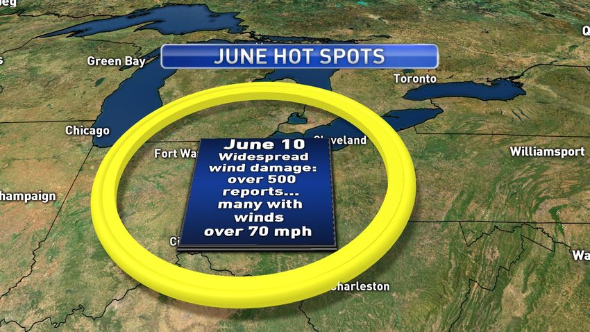
Let’s get smart
PLEASE use good safety practices if you plan to set off your own fireworks this year:
Obey laws regarding the discharge of pyrotechnics in your area. There’s enough of “those” neighbors
already, and they tie up police from dealing with more important matters.
If you are the one firing up the fuse, wear safety glasses.
Open flames are dangerous, a “punk” lighting stick is the way to go. NEVER use matches or a cigarette
lighter to “light ‘em up”. Bad move. Unsafe!
Keep a hose or bucket of water handy in case a wayward rocket gets the best of you.
Do not set off airborne fireworks if your area is experiencing a drought. Firecrackers and such are OK
on a non-flammable surface like a driveway.
Do not discharge fireworks near heavily wooded areas, or near large expanses of grass or brush. This
may seem like a no brainer, but oh well!
Fireworks should not be launched from a boat or other watercraft.
Extinguish “duds” with water. Squishing them with your shoe isn’t 100 percent effective.
Do not allow children unsupervised access to fireworks, and this includes teenagers. It is strongly
recommended that all fireworks be set off by adults.
Forty percent of normal…
Now to weather. If you’re a storm chaser, you had slim pickings again in June as we saw our second
consecutive month with much below average tornado frequency. In fact, we had more twisters in April of this
year than in May and June combined, which is VERY unusual. June bore about 100 tornadoes against a long-
term average of some 250, just 40 percent of normal!
Tornado count YTD thru June 27 is 707 versus a long-term average of 812, with May and June very quiet / SPC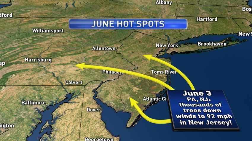
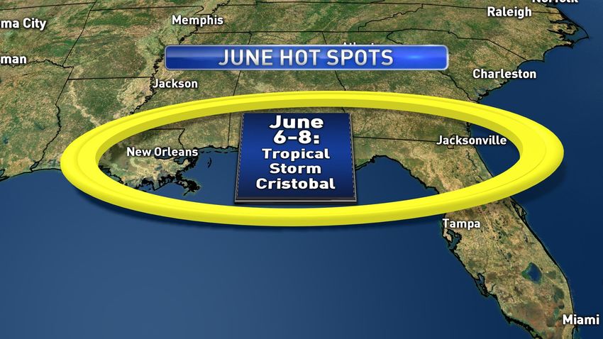
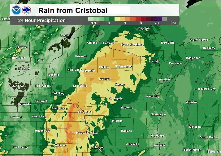
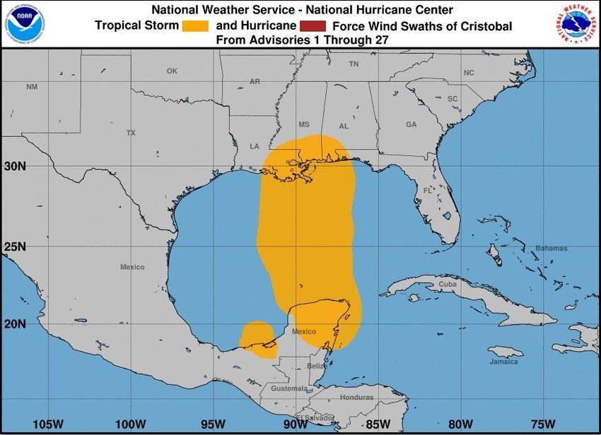
Cristobal: Orlando tornado, Gulf Coast deluge, rare northern visit
The big danger with weaker tropical storms is inland flooding and the occasional tornado. Cristobal produced
both, a significant (EF1) tornado scraped through portions of the Orlando metro area on June 6 th. It was
associated with a spiral rain band from Cristobal, a common place for tornadoes to form in these systems.

Big-time rain also fell: over 13 inches in parts of the Florida Panhandle and 10 inches around the Mobile area,
making for plenty of flooding, but most of it was not severe.

We’ve had four named storms through June 30, the only one that caused any serious issues was Tropical
Storm Cristobal, making landfall south of New Orleans on June 7. It was not an especially well organized storm,
most tropical storms have a fairly small area of winds between 39 and 73 mph, Cristobal had a much larger
radius of strong winds:

The orange area represents winds of 39 mph or greater along the path of Cristobal/ National Hurricane Center

Cristobal joined the rare ranks of just four tropical systems since 1860 to impact the western Great Lakes
states, the core of the system made it all the way into Wisconsin where it left a footprint of heavy rainfall as a
non-tropical low pressure system:
National Weather Service

June: A few tornadoes, but hammered by high winds
A number of intense high-wind events blasted the eastern U.S. during the month, including back-to-back
clobbering’s for Pennsylvania and adjacent states June 3-4. The June 3 event featured numerous reports of
winds over 80 mph across three states, two people died, one when a tree fell on his car, another in her home
after a fire was started by a falling tree.

Just a week later an equally fierce event sent hurricane force winds across Grand Rapids, Michigan and grew
into an even larger wind-damage event by the time it reached eastern Michigan and Ohio. Over five hundred
reports of downed trees, power lines, damaged outbuildings and battered roofs came in, similar to the June 3
event. These are big-time happenings and each of them caused hundreds of millions of dollars in damage.
Because the destruction was not concentrated as in a tornado, these events typically get less media coverage
but believe me it was a mess!

Here are some of the bigger events during the month…
Even though “Cristobal” didn’t make landfall in southern Louisiana until the 7th, some of the greatest effects
were far away from the center in Mobile, where 10 inches of rain fell, and of course in Orlando where an EF1
tornado spun through parts of the city on the 6th.
Other notable June wind events
It was just a monster month for wind! A total of 4,428 reports of high winds and/or wind damage were logged.
June 2: wind damage corridor across WI, MI, western NY, winds in 60 to 70 mph range.
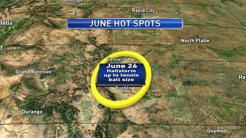
June 6: Fierce thunderstorms over CO, WY, and also over Massachusetts, over 300 reports; Colorado’s
Winter Park Ski area had a measured wind gust to 110 mph, 78 mph was clocked near Denver Intl
Airport, considerable damage across the northern half of the state including the Denver Metro.
June 22: High winds blow off a motel roof in San Angelo, TX, lots of trees down in VA, MD, PA
June 26: Thunderstorms slam a corridor from Chicago to Detroit with tree-and-power-line type of
damage, in such a heavily populated corridor it is no doubt making for thousands of claims.
Saharan Dust Damper
Most likely you’ve heard about the huge dust cloud that came out of the Sahara in late June, it was pushed
westward by hot winds around desert low pressure, across the Atlantic into the Caribbean and southern U.S.
It’s not an especially rare event, but one of this magnitude is. Caribbean islands like Puerto Rico and the
Caymans reported their worst Saharan dust event in at least 30 years. The dirty brown cloud affected millions
of residents and visitors to the island nations, causing respiratory problems and making for murky skies
instead of the usual tropical blue.
Steering winds eventually pushed the dust toward the skies of Texas and Oklahoma, too. The effect is vividly
illustrated here over Texas where it offered an almost “extraterrestrial” sunset:
A dust-laden sunset near Lake Texoma, TX on June 27, 2020 / Steve LaNore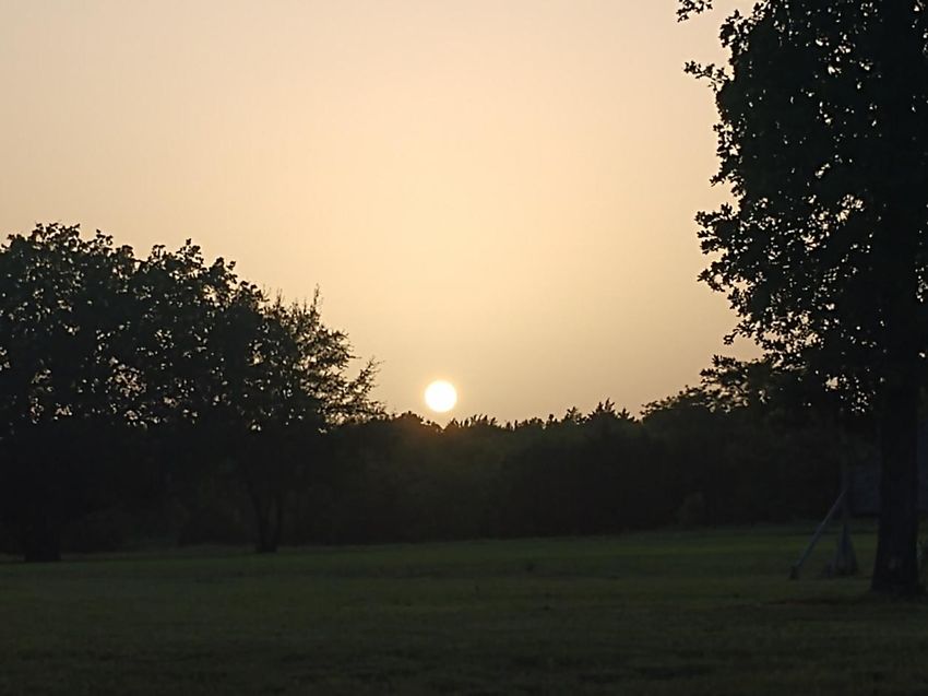
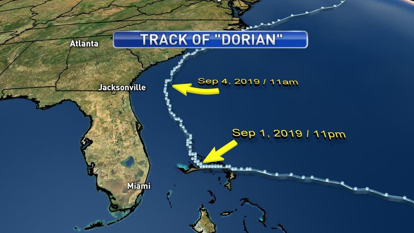
There was a slice of good news in all of this: Saharan dust events pump a lot of dry air over hurricane breeding
grounds, pretty much preventing tropical cyclone formation while it’s going on. Each burst of dust only lasts a
few days so it really won’t have an effect on the peak of the season unless we get a lot more of them, which is
possible but no probable.

Tropical Update
Don’t let the “out of Africa” dust fool you, the overall pattern (warmer than normal ocean surface, moderate
shear) still favors above average activity as we get deeper into the Atlantic Hurricane season. Tropical activity
generally picks up in mid-August and lasts until mid- October.

Some recent examples of U.S. impacts in this time frame include Hurricane Irma in September of 2017,
Hurricane Florence in September of 2018, Hurricane Michael in October of 2018 and Hurricane Dorian in
September of 2019.

There’s no way to say for sure where a hit will come, but the odds for the Gulf coast getting one are slightly
higher than normal due to the expected extra-strong high pressure cell off of the east coast. Florida has gotten
a lot of hurricanes the past few years but has also been quite lucky on two occasions: in 2016 Hurricane
Matthew paralleled the coast only 40 miles offshore, and “Dorian” tracked in a similar fashion about 100 miles
offshore in 2019. Talk about luck!

Hurricane “Dorian” did horrific damage to the northern Bahamas, but it missed the Florida coast / NHC data

July Outlook
Tropics: The mid-summer period is generally rather quiet for severe weather with scattered straight-line
episodes the primary threat. Of course, there’s the tropics but storms in July are rather spotty, we average
one named storm in July per year. And, an active June does not mean July will be the same.
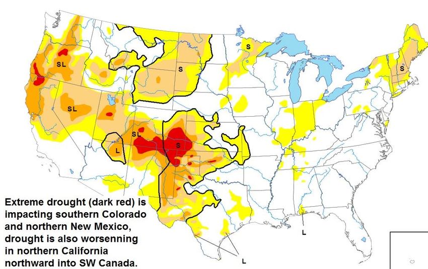
Fires: Here’s the latest drought monitor:

So, it looks like another tough summer in the west, years of persistent drought got only a little relief last year
and now it’s getting to the level of high concern once again. Strong winds often fuel western wildfires so that’s
what will need to be watched. “Dry” summer thunderstorms produce a lot of lightning but little rain over
many mountainous areas, and this is what starts a lot of the fires in the summer, but less so in California.

The largest fire in the United States is located in western Utah, the 66,000 acre Canal fire. It has destroyed 34
structures and was only 10 percent contained as of press time. The story of this fire is all about those “dry”
thunderstorms: the fire was started by lightning and quickly contained at 450 acres on June 27, but then high
winds allowed the fire to jump the fire lines and just explode in size and ferocity. It reached 30,000 acres on
June 29 and 66,000 acres as of press time on June 30.

The above map shows most of Utah in a moderate drought (tan color), so this is just an example of what can
happen when the winds are wrong. We have the makings of a rather “bad” fire season. Stay tuned and hope
for the best.

Take Care,

Steve LaNore, CBM
You can also read


