www.saxons-oc.org Spring 2021 - Saxons Orienteering Club
←
→
Page content transcription
If your browser does not render page correctly, please read the page content below
Issue 187 www.saxons-oc.org Spring 2021
SAX NOTICES
                    RETURN TO ORIENTEERING
   Organised outdoor orienteering, including competitions and
    coaching, can resume in England from Monday 29 March
                     2021. More info here.

                       COMPASSSPORT AWARD
    SaxAlert wins its 10th CompassSport award in 14 years!
               See Editorial & Chairman’s Chat.

                               CONTENTS
  Editorial                          3    Acute Oak Decline           38

  Chairman’s Chat                    4    Leagues:                    40

  Future Events / Events Further     6    Kent Night Cup              40
  Afield
  Welcome to New Members             7    Kent Orienteering League    40
  SEOA Badges                        8    MapRun Winter Series        40
  MapRun & POCs                      9    South East League           41
  Coach’s Corner                     10   UK Orienteering League      42
  Letter From The Lakes              15   Southern England            42
                                          Orienteering Urban League
  Letter From Yorkshire              16   Saxons Out & About          43

  The Missing Maps Project           17   Tree Puzzle Answers         44

  Tree Puzzle                        20   Credits                     44
  O-bscurities Part 2: The History   20   Club Committee & Officers   45
  and Heritage of our MapRun
  Courses

SaxAlert No. 187 Spring 2021                                               2
EDITORIAL

                        T
                                  wo issues ago, in spring 2020, my editorial
                                  started 'Welcome to a most unusual issue of
                                  SaxAlert.' The year since then has seen little
                                  organised orienteering (thank goodness for
                        MapRun) which makes this edition perhaps an even
                        stronger candidate for the title of 'most unusual issue of
                        SaxAlert to date.'      There just hasn't been much
                        orienteering to report on. Yet thanks once again to the
                        enthusiasm and commitment of our contributors, it has
                        been possible to put together this issue. Clearly there is
                        much to say about orienteering even when there is
                        hardly any orienteering going on!
But there is now, at last, some light at the end of the tunnel. It would be
premature to claim that we have wholly seen the back of Covid-19, its variants,
and lockdowns. However, restrictions are now being lifted enough for organised
outdoor sports to re-start. Saxons already have a number of events planned
through to late June, as do our neighbours DFOK and SO. I'm sure you don't
need me to tell you: get out there, get stuck in, and make orienteering's re-start
a good'un. And spread the word - after almost a complete year's absence from
the woods and streets, orienteering will have lost visibility with the general
public. We need to get the message out more strongly and widely than ever
about what a great, fun sport it is. With the increased focus recently on using
the great outdoors to boost physical and mental health, that shouldn't be too
hard a sell.
Finally, it is a pleasure to end on a piece of good news. Once again SaxAlert
has won an award from CompassSport, the UK's orienteering magazine. This
award is made annually to the top 6 club magazines for their content and layout
(they are not ranked), which is an achievement just in itself. But - and I'm really
pleased to be able to say this - Saxons are now the best club overall in the
CompassSport awards, across the whole of the UK. Out of the last 14 years,
we have won 10 awards - the next closest club, ESOC (Edinburgh Southern)
have 9 awards.         Our success is reflected in the banner awarded by
CompassSport: 2009-17 and 2020.

SaxAlert No. 187 Spring 2021                                                     3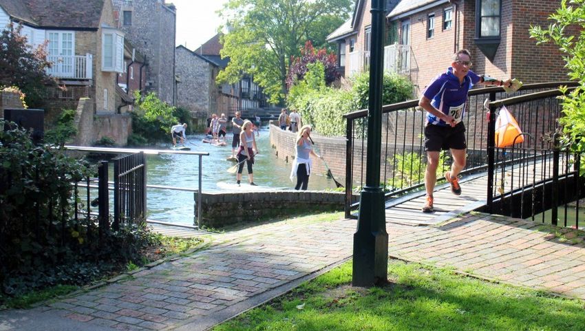
This wouldn't have been possible of course without your contributions and the
hard work of a number of editors. Rowan Purkis started SaxAlert and
developed it over some years to win those first awards. Heather Brown took
over for a while after Rowan and Jerry moved to the Lake District, and Neil
Bricknell also edited some issues recently. The 2020 award and topping the
clubs leaderboard are the results of years of combined, sustained effort on
SaxAlert. Thank you all for your help - let's keep it going long into the future!
As ever, Saxons - stay safe, stay well, and see you out on the courses soon.

Graham Denney

                        CHAIRMAN’S CHAT
                              Jean Fitzgerald

                    I
                            hope you have all been keeping fit and active
                            during the absence of opportunities for
                            conventional orienteering. During the current
                            lockdown we have organised more MapRun
                    events, thanks to the efforts of Simon Blanchflower, and
                    have arranged for the reorganisation our website to reflect
                    the need to advertise more than the ‘normal’ orienteering
                    events to members and potential newcomers.
                    Zoom has been a great way to keep in touch during the
pandemic and the club has been using this for a variety of events. We have
held a couple of Orienteering quizzes, which were well attended and have also
used this platform for on-line training/coaching events which were very useful.
The main driver for these has been Brendon Howe. We have also been using
Zoom for our regular committee meetings and held our first virtual AGM in
November. At the AGM I was re-elected as Chairman, and all the previous
committee members agreed to serve for another year.
Now under the government’s ‘roadmap’ to unlocking England, we can start to
organise more mainstream orienteering. Your committee have discussed this in
some detail, and the plan is to have a series of five ‘unlocking orienteering’
events between now and the early summer. These will all be local events and
will be on Saturday or Sunday and all will be pre-entry only. The first 2 events,
at Blean on 18 April and Angley on 9 May, have now been confirmed and I’m
really looking forward to seeing many of you out in the forest again. Further
details will be on the website shortly. We are waiting for permission for access

SaxAlert No. 187 Spring 2021                                                    4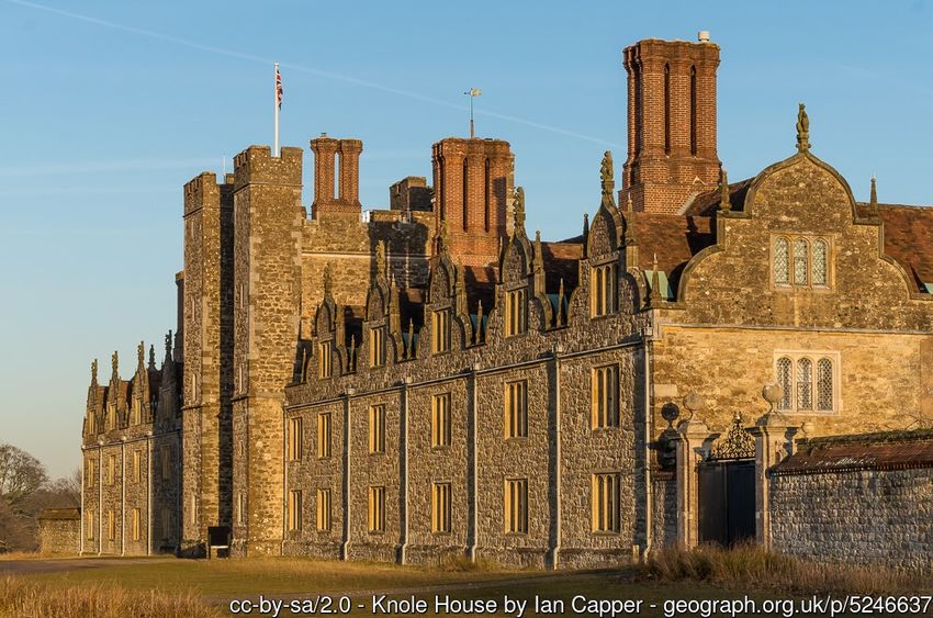
for the other proposed venues. We may add some evening events into the mix
so do keep an eye on the website. We also hope to be able to organise a club
BBQ and novelty event some time over the summer. Then (covid permitting) we
hope to start the new season in September with the normal range of KOL, KNC
and Sunday events.
Those of you who read CompassSport, or check the news on our website, will
have seen that SaxAlert won another award for content during 2020. This is
down to the hard work of the editors Neil Bricknell and Graham Denney.
CompassSport also makes an award for the best cover of a club magazine. It
would be great if we could pull that off too, so get your phones/cameras out and
start snapping. If you do have any good images, we could also do with some for
the website! Going forward SaxAlert is becoming a digital only magazine. This
enables the editor to use hyperlinks to maps, quizzes etc to make the magazine
more exciting and interesting for readers and it can be produced in full colour. It
will also reduce paper use and postage costs. I hope you all approve.
Looking forward, in 2022 Saxons will be 50!! We intend to organise something
extra special for this anniversary, and would be happy to receive any
suggestions from you to help make this a memorable year.
Jean
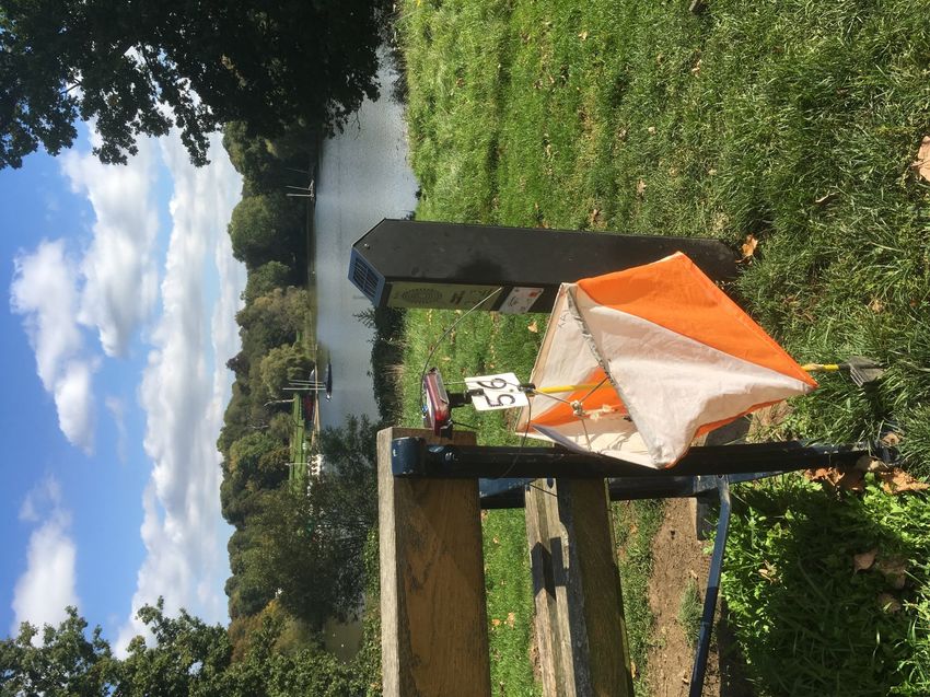
Start at KOL2 at Blean, 17th Oct 2020
Credit: Saxons website
SaxAlert No. 187 Spring 2021 5
FUTURE EVENTS

N
             ow that organised outdoor orienteering is allowed to resume, we have
             already planned the following events, as well as one more online
             training session:
                                                           Please contact
 Fri 09 Apr                  Sprint Race Training          team.captain@saxons-oc.org to
                                                           reserve a place
                                                           Parking in Marden Station Car
                                                           Park - TN12 9HS. £4 all day.
 Sat 10 Apr                  Marden Sprint Double Header
                                                           What3Words:
                                                           tweezers.plenty.fever
                             Blean Local Event—Back To     Faversham/Canterbury
 Sun 18 Apr
                             Orienteering Series Event 1   Postcode: CT2 9LE
                                                           Cranbrook
 Sun 16 May                  Angley Wood Local Event
                                                           Postcode: TN17 2PY
                                                           Sevenoaks
 Sat 22 May                  Knole Park Local Event tbc
                                                           Postcode: TN15 0RP
                                                           Tonbridge
 Sat 05 Jun                  Haysden Local Event tbc
                                                           Postcode: TN11 9BB

                                                           Maidstone
 Sat 26 Jun                  Mote Park Local Event tbc
                                                           Postcode: ME14 5SS

You can find out what orienteering events are coming up locally and throughout
the country by app, Web or email:

                •         Use Neil Bricknell’s Event-O app (Google Play or Apple App
                          Store)

                •         Visit the Saxons website events page

                •         Visit oevents.info and use their online events calendars

                •         Use the British Orienteering Event Finder

                •         Subscribe here to oevents.info’s weekly events list email

Icons courtesy of Online Web Fonts

SaxAlert No. 187 Spring 2021                                                               6
Events Further Afield:
World Orienteering Day:
World Orienteering Day 2021 in May is postponed and will now be taking place
8 - 14 September 2021.
The difficult Covid-19 situation worldwide has forced the postponement of
World Orienteering Day. Any activity held between Wednesday 8 September
and Tuesday 14 September 2021 can be registered as a World Orienteering
Day event.     Register an event/activity or find out more here: https://
worldorienteeringday.com
Lochaber 2021 Update:
With 1300 entries already, the organisers are confident of attracting the 2000
that are needed to make the event viable. The planners have created some
great courses amongst glorious Highland scenery, and the event has gained
fantastic support from all of the landowners. Inevitably there will be some
changes due to Covid-19 precautions—please visit the link above for more
details.
World MAZE Race—Sat 29 May:
World MAZE Race is a global competition in MAZE-Orienteering all over the
world! Registrations are open and clubs from 37 locations in 20 countries have
already signed up—China, Colombia, Finland, Italy, Jordan, Lebanon,
Mozambique, Pakistan, Poland, Portugal, Republic of Moldova, Russia, Serbia,
Slovenia, South Africa, Spain, Sweden, Thailand, Turkey and the United
Kingdom. Schools can join in as well as clubs. Event registration is at
www.worldmazerace.online

               WELCOME TO NEW MEMBERS
Senior: Sian Griffiths

W
Family: Leo, Tina, Chloe and Isla McCullough
              elcome to the club! We hope to see you at local events very
              soon. Please make yourselves known to the organisers and the
              'Can I help you?' volunteers at our events. Also our Junior Co-
              ordinators look forward to meeting new Juniors.
Sian Griffiths tells us a bit about how she became involved with orienteering:

SaxAlert No. 187 Spring 2021                                                     7
“A few years ago I discovered TREC
                                         (orienteering on a horse) and have
                                         really enjoyed competing and helping
                                         to organise events. I have been
                                         fortunate to visit, and get lost in, some
                                         lovely places! TREC uses OS 1:25K
                                         maps so I am looking forward to
                                         learning to use a different scale and
                                         map legend. Without a horse to do all
Sian at the TREC 2019 Championships in   the hard work, I’ll have the challenge
Scotland / Credit: Sian Griffiths        of improving my fitness levels.
                                         The Saxons online training sessions
 have been really useful and I’m looking forward to meeting everyone and
 trying my first orienteering event when Covid restrictions allow.
 Best wishes
 Sian”

                            SEOA BADGES
               Send off for your free colour course badge!

 Y
           ou can get a fabric colour coded badge to sew on your track suit or O
           top, sponsored by the South East Orienteering Association, if you
           beat the par time three times, on any qualifying colour-coded course.
           Three qualifications at the same colour get you a badge - there is no
 time limit on when you can get them.
                          Par time is set at 150% of the winner’s time, or within
                          the top 50% of competitors, whichever is greater,
                          except for the White course, where you only have to
                          complete the course three times to qualify.
                         To obtain your badge, please send details of your
                         qualifying results (organising club, event, course and
                         orienteer's name) plus a stamped addressed
 envelope, to Anne Power, 6 Mallard Close, New Barnet, Herts EN5 1DH, or
 email Anne from the SEOA website Contacts page (https://www.seoa.org.uk/
 contacts). There is no charge for these badges, and Seniors and Juniors alike
 are eligible for them!

SaxAlert No. 187 Spring 2021                                                         8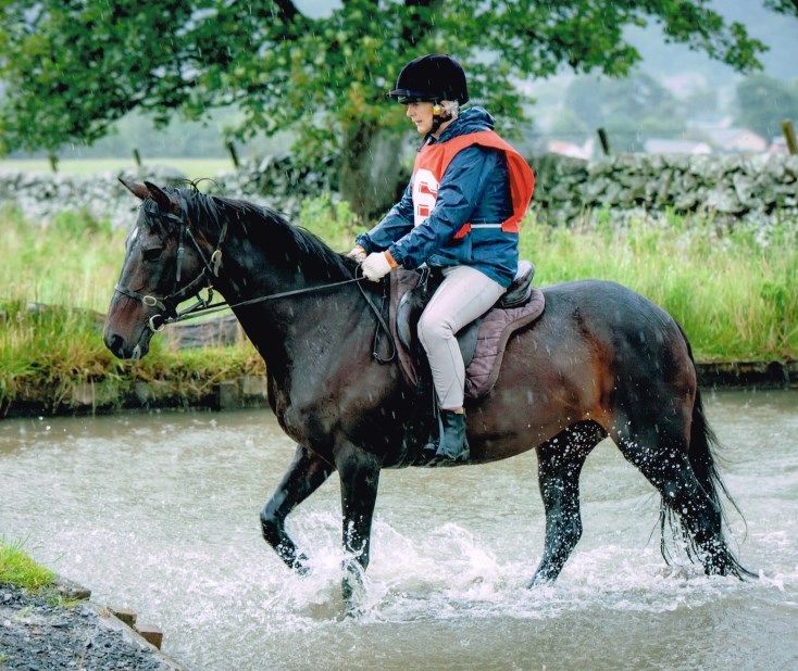
MAPRUN & POCs
                                Beryl Pring

M
            apRun is a free app that allows you to run a course without any
            physical infrastructure on the ground—instead your position is
            recorded by the phone’s GPS. You can run solo anytime and your
            time can be compared with others. It is perfect for private fitness
            and technique training.
We have 21 courses on our website for you to choose from. From Deal in the
east to Tunbridge Wells in the west with Ashford, Maidstone and Leybourne in
the middle. Some of you have done them already but there are a lot of you that
haven’t and it is well worth having a go. They get your mind back into map
and compass mode after having such a long time out of orienteering. Most of
them are streets and lanes with the odd bit of path and grass. They are easy
places to get to and parking is generally close by.
SO and DFOK both have similar depending on where you live: just go to their
websites to access the information.
Permanent Orienteering Courses
Also don’t forget our permanent courses at Milton Creek, Mote Park, Brockhill,
Bedgebury, Betteshanger and the University of Canterbury. You may not be
able to get maps for some at the moment, but the first three are on the British
Orienteering website. Also at the present time Trosley is not available as we
are going to update it. If you do have a map already though it is still open.

                 Urban orienteering in Canterbury—also one of
                   our MapRun venues / Credit: Saxons website

SaxAlert No. 187 Spring 2021                                                      9
COACH’S CORNER
                               Brendon Howe
Contours—A Primer

A
What is a Contour Line?
            contour line (often just called a "contour") joins
           points of equal elevation (height) above a given level,
           such as sea level.
             The diagram shows the relationship between a stylised hill (shown in
profile at the top) the the subsequent Contour ‘rings’
                                    Contours essentially give us the third
                                    dimension on a 2D map and show where
                                    the hills and valleys are and how steep the
                                    terrain is.
                                    Contours are very helpful for the orienteer in
                                    that they are one of only two things we can
                                    rely 100% on: Contours and Compass.
                                    Many elements of an orienteering map can
                                    be open to interpretation or can change over
                                    time. I’m sure you’ve all had that “is that
                                    path on my map?” or “is this a white bit or a
                                    green bit?”. With contours you can be pretty
                                    sure where you are. For example, if you're
                                    on the top of a hill you know exactly where
you are on the map.
Remember, a good mapper will only include detail on the map that will aid the
orienteer and their navigation. This will often mean removing the ‘clutter’ of
minor features; contours are never removed. Recognising the consistency of
contours can help supercharge our orienteering.

What do they look like?
On an orienteering map contours are usually shown at 5 metre intervals,
although 2.5m can be used on some maps if useful for the orienteer and the
terrain dictates. This will be identified at the top of the map alongside the map
scale.
Contours, like other ‘Earth features’ are shown in brown on the map.

SaxAlert No. 187 Spring 2021                                                   10
There are three contour types:
• Standard contours (as described above)
• Index contours - These are the same as standard contours but show
25m increments of height (for a 5m contour map). Essentially, every fifth
contour.
• Form lines - These show specific land shaping that would otherwise not
appear on a contour map because the feature is smaller than 5m. These
are shown as a dashed brown line. Again, these are only included when
helpful to the orienteer.
In this map extract you can see:
Contours
Form Lines
Index Contours
Which way is up/down?
The concept of a contour is relatively simple for most orienteers to grasp. The
thing they often struggle with is working out what’s the bottom and what’s the
top.
We’ve all spent time in a race searching the valley bottom for a control that was
on top of the next ridge!
Unfortunately, discerning ‘up or down’ is not always obvious. There are some
things that can help us however…
Tag Lines
Tag lines are used on a number of orienteering map features. They always
point downwards. For example, cliffs, earth banks, quarries and larger
depressions have tags.
A mapper will include tag lines on contours if they feel there is likely to be some
confusion over up or down.
SaxAlert No. 187 Spring 2021 11In this map extract you can see the mapper has added tags
to the contours to show the depression feature in the
centre.
Rivers and Water Features
Helpfully water was invented to run downhill. Left to its own
devices it tends to
collect at the
bottom of things. Looking at water
features on the map can help us to
identify the shape of the land and what
the contours mean.
Take this example, you can see the
streams are running down to the river
in the open land.
Marsh areas will sometimes form the
source of a stream as seen here.
We do need to be careful as marsh
can also appear at the bottom if there
is not good run-off for the stream. This
usually coincides with flatter terrain.
Re-entrants
Contour shaping on a hillside is often
caused by water. A fast moving
stream will form a V shaped gully. This
will shown a tell tale V shape in the
contours even if the stream is no
longer present. If we take the map
extract here, we can see a distinctive
V shape formed at the North.
Spurs
On the other hand, Spurs tend to have
more of a rounded profile. This map
shows a broad spur in the central
section.
Not every spur or re-entrant will be
obvious when you look at the map.
SaxAlert No. 187 Spring 2021 12Look along any slope on a map and you will see one or two tell-tale re-entrant/ spur features that tell the direction of the slope. Hill Tops Hill tops often present as a series of concentric circles leading to the top. See the map extract here. Depressions, on the other hand, don’t tend to appear in the same way. They’d probably be full of water and be shown as a lake instead. It is often possible quickly to identify the hill tops on a map by spotting the concentric circles. Up or Down - Final thoughts All of the above clues can help you to identify which way is up or down. None of them should be used exclusively, but should be part of a process of building evidence. ‘Geeking’ a map before a race is worthwhile. Spend time visualising the shape of the terrain you’re going to be racing on before the event as this will save lost time trying to fathom it mid-race. Practising Contours - Drills and Exercises Ultimately, the best way to get better at identification is through practice. Here are some non-race drills you can try locally. Draw the Contours Find some hilly terrain nearby and choose a small segment of it, say 100m square. Take a pencil and paper and try to sketch out what the contours would look like. By all means pace out the area to get a sense of height gain, steeper bits and shallower gradients. Think about how re-entrants and spurs are shaped differently. When completed, compare it to an official map of the area (if you have one), or compare it to a companion’s effort. The purpose of the exercise is not necessarily to create an exact representation of the contours, but to get you thinking about interpreting the 3D shapes into 2D. SaxAlert No. 187 Spring 2021 13
Build Contours in Sand
Take an extract of an old orienteering map and re-create the terrain in sand.
You can also use snow, or mashed potato.
Walk the Contour
When you’re next out for a walk somewhere open and hilly, try following the
contour. Try to avoid ascending or descending, but try to get a feeling for the
shape of the land.
Do make sure to walk back the other way (at a different elevation). This will
ensure one leg doesn’t remain longer than the other :-)
Contour Only Maps
Obtain a contour only map of your local orienteering area. Plan some simple
course legs and try to find your way using just the compass and contours.
A couple of contour only maps (along with their full versions) can be found in a
shared Google drive here: https://tinyurl.com/yve9we5
[The full URL is: https://drive.google.com/drive/
folders/1jLPDcz6cGeguN5tGoGNpcDALx1Oyp9T_?usp=sharing ]
Please bear in mind that you do not have the landowners explicit permission for
access; however, the chosen areas are open to the public and facilitate
roaming.. In the shared drive you will see a Notes file; please take time to read
this before printing and using the maps.
Routegadget Review
Check out Routegadget online and chose a map area and race. Follow the
course around and practise using your identification skills to work out whether
you would be going up or down on each leg.
As an extension exercise, try to draw the height gain/loss profile of your route.

Conclusion
Contours are easy to understand, but difficult to master. Taking time and effort
to understand and practice them is extremely worthwhile.
Relying more on them during a race will help you simplify your route choices
and speed up progress. This is particularly true in more challenging terrain
where paths are not present: Scotland, Lakes, Europe, Scandi.

SaxAlert No. 187 Spring 2021                                                        14
LETTER FROM THE LAKES
           Rowan Purkis, Saxons 2003—2018 now LOC

M
            any of us will have discovered
            things and places because of
            the coronavirus, that we might
            not have done before. In our
            case it’s Wainwright’s Outlying
Fells.
His first 7 books are very well known; the
214 fells that he climbed are the goal of
                                             Credit: Rowan Purkis
many. Jerry managed to scale them all
within one year of us moving here. In the “Guide to the Outlying Fells”
Wainwright aimed “to cater for those walkers who, because of age or infirmity,
                              must be content with milder expeditions on
                              lesser fells.”
                                As the proud owner of a new hip that needs
                               gradual introduction to hill climbing, the Outlying
                               Fells is a perfect challenge, all 116 of them and
                               luckily for us, most of the are in the South and
                               East of the Lakes where we live. The highest
                               is Walna Scar at 621m near Coniston and the
                               lowest is Humphrey Head at 53m. So far, we’ve
walked up just 29, 20 of which we went up in 2020 and 3 so far in 2021. Here’s
a map of them all, the ones in red are the ones we’ve been up and you can see
we have been very good and stayed local. Many are orienteering areas and
we’ve had our old maps out to help find the
high points on Finsthwaite Heights, Bigland
Barrows, Simpsons Reservoir, Stickle Pike…
to name but a few.
The top photo is Jerry on “Staveley Fell”
which is very close to Simpsons Reservoir.
To find the Outlying Fells, register with
www.hill-bagging.co.uk and use map search.
But to be honest the pictures and narrative in
Wainwright’s book should not be missed.

Rowan Purkis

SaxAlert No. 187 Spring 2021                                                    15
LETTER FROM YORKSHIRE
Bill Griffiths
Not to be outdone by his Cumbrian neighbours, former Saxon Bill Griffiths
O
kindly gives us the view from the other side of the Pennines.
rienteering life slowly continues in North Yorkshire. The lockdown
prevents very many orienteering events and my own club (EBOR)
has held very few proper orienteering events over the last few
months. An event near Scarborough in mid-April has been put
back a year at the request of the landowners. An event at the end of May
already has a big question mark against it (the assembly area is needed for a
much-postponed football competition – which seems to trump orienteering)
and only a local (level D) event in York at the end of March seems to stop the
disappointing trend.
Luckily the other Yorkshire Clubs have been more successful with no less than
six level D events in April and one level C. And six events in May, including
one HALO event that I have been involved with (they used my map!)
But even in Yorkshire, Kent has seldom been out of the headlines. Our news
programmes seem to have been filled with Kent stories about Brexit and
Migrant issues. One story certainly took me back to the
1980’s when I started orienteering in the South East. There
are probably few orienteers still around today that remember
the Police attending an event in Epping Forest. They were
looking for witnesses to a horrible abduction and murder and
were hoping that orienteers might have some evidence for
them. (A body had been found in the forest). So, the
Dering Wood— memory came back last month with the discovery of Sarah
click for larger Everard’s body in Hoad’s Wood, near Great Chart. Now I
image don’t think I have orienteered in Hoad’s Wood, so I am not
expecting a tap on the door
from the “boys in blue” in the near future. But
nearby Dering Wood was a SAX regular in the
early 1990’s. Also known as Pluckley’s
Screaming Woods, after reports of screaming
there – maybe (according to contemporary
writers) by people who got lost in the Woods and
died. There have also been many reports Moat Wood—
(according to web resources) of footsteps in click for larger
dense woodland. A ghost of a soldier is said to image
SaxAlert No. 187 Spring 2021 16walk along the path in woodlands. The ghost of a suicidal
army colonel of the 1700s dangles from a tree. In the 1990’s
the Club Chair (and very much its leader) lived near Dartford,
so a trip this far east was rare. Moat Wood (near
Shadoxhurst) was an occasional O-venue in the 1980’s. The
terrain was dead flat and had a note on the map “THE AREA
IS FLAT – NO CONTOURS”! And not forgetting my first Priory Wood—
SAX area in June 1983 at Priory Wood near Aldington. click for larger
So whilst Yorkshire emerges from a (seemingly) very long image
lockdown, and we are not allowed to travel to Kent, the
county is seldom far from our thoughts.
Bill Griffiths
Allerston, Yorkshire
[Thanks to Bill for also providing the map images—a fascinating glimpse into
the club’s history. And for more recent members—yes, we did hand-draw our
routes onto maps in those days! - Ed.]
YOU ARE HERE—THE MISSING MAPS PROJECT
Alasdair Shaw, Chairman, Quantock Orienteers
A recent news item on the British Orienteering website caught my eye:
Quantock Orienteers are involved in a global humanitarian project to produce
maps of vulnerable areas across the world. This sounded interesting, so I
invited QO to tell SaxAlert readers more so we could help out too. QO’s
Membership Officer, Judy Craddock, put me in touch with their Chairman,
Alasdair Shaw, who kindly wrote the following article—Ed.
T
he Missing Maps Project was
set up by the British and
American Red Cross,
Médecins Sans Frontières, and
Humanitarian OpenStreetMap
Team (HOT) to produce maps of
vulnerable areas in the developing world
that can be used to support humanitarian
aid and disaster relief.
Credit: Missing Maps Project, CC BY 4.0
SaxAlert No. 187 Spring 2021 17Many areas of the world do not have good, or any, mapping.
When teams go into a disaster area they don’t have access to basic information
like road and track access, where and how many buildings there are, what local
infrastructure there is. Even something as simple as a landslip blocking the
known access road could hold an aid convoy back days if they don’t have
accurate mapping of alternatives.
Crisis modelling groups work to predict the effects of things like global warming,
individual storms, deforestation, and so on. They need good maps to be able to
judge what the effects will be and work on preventative measures.
Planning teams for things like vaccination campaigns and flood relief schemes
need accurate and up to date maps of individual buildings and access
networks.
The list of reasons for mapping goes on…
I was looking for something to do during Lockdown that could help. As I
continued working as a teacher throughout, and am clinically vulnerable so
couldn’t do any of the things that
required face-to-face interaction, I
was excited to find that I could do
this from my own home.
When I first saw the list of projects,
Credit: Missing Maps Project, CC BY 4.0 I knew it was something I wanted to
do. Many were looking at flood risk
assessment in very deprived areas faced with tropical storms, others creating a
picture of the building distributions in advance of polio vaccination drives, and
some trying to connect remote villages.
As a club, we thought it would be something that our
members would find rewarding, so we added the
Missing Maps Project to our Lockdown activity
suggestions, alongside our online planners course
and our virtual LEJOGLE.
We’ve had several members let us know what a
wonderful idea it was and that they were getting
involved. I know that some families have turned it
into a personal challenge to see how much they can
map. And then there will be others who have dipped
in when they had some spare time and done a
square or two.
Credit: Missing Maps Project, CC BY 4.0
SaxAlert No. 187 Spring 2021 18The mapping is all done on OpenStreetMap, something many orienteering
planners will be familiar with in creating base data for simple street orienteering
events.
You need to be able to identify features on satellite imagery, trace them, and
correctly label them as paths, roads, buildings, rivers, bridges, etc. Each project
has a particular focus – some are only interested in road and track networks,
others in watercourses, or buildings, while others just want everything you can
identify on the imagery mapped.
The area in each project is divided into smaller squares so you can tackle one at
a time. While you are working on it, it is locked so others can’t change things. If
you have to stop before finishing, you can release it back into general circulation
so someone else can finish it off.
Once all the remote mapping has been done by people from around the world,
local volunteers add information such as which buildings are schools, which are
hospitals, where evacuation centres are, fords that aren’t crossable in certain
conditions, etc.
Projects are initiated by a variety of organisations. One that I’m contributing to
personally is from the World Bank looking at flood-prone areas of Malawi.
Another is from Public Lab Mongolia, an NGO based in Ulaanbataar that works
on environmental, youth engagement and community health projects.
The projects are coordinated by the HOT Tasking Manager and are ranked by
urgency. You can also filter by difficulty or part of the world.
Credit: Alasdair Shaw, Missing Maps Project, CC BY 4.0
Alasdair created this map of
villages in Nigeria in late March.
He says: “The project is mapping
remote villages in Nigeria and
tracks to reach them for vaccine
delivery. Before I did this tile there
was no map, so I was able to
identify three villages and tracks to
allow vehicles to reach them.”
Click image for full-size version.
SaxAlert No. 187 Spring 2021 19TREE PUZZLE
Simon Greenwood
S
ee if you can identify the trees from the clues below. Answers on the
inside back cover (no peeking!)
1) Beat schoolboy 2) Simian quiz
3) Old joke 4) Linden prevents scurvy
5) Victory wreath 6) Culinary window
7) Missing someone 8) Cockney takes the ship’s
steering
9) Found under grates 10) City in flight
O-BSCURITIES—Part 2
The history and heritage of our MapRun courses
Graham Denney
Part 1 of this article (see previous issue of SaxAlert) covered the first 5 areas of
our Summer MapRun Challenge series. In this article I conclude by peeking into
some of the more obscure histories of the remaining 5 areas – Tonbridge &
Haysden, Canterbury, Knole Park, Vinters & Maidstone East, and Saltwood &
Hythe.
[Click any of the map thumbnails below for an annotated PDF map. Please note
that maps are used for events with the landowner’s agreement].
Week 6 Challenge - Tonbridge & Haysden:
P robably Saxon in origin, the 'Lowy' of Tonbridge - an area up to
approximately two miles around the castle with its own legal and
administrative system - is documented as being given by William the Conqueror
in 1066 to his kinsman, Richard fitzGilbert. The town grew up around the castle
and the river crossing - hence the north end of Tonbridge is by far the oldest
SaxAlert No. 187 Spring 2021 20part. At fitzGilbert's time there probably
wasn't a bridge either, as we would
recognise one today: there may have
just been causeways over streams and
the Medway.
By the mid-1200s 'Tonebrugg', as it is
referred to in royal documents, was
encircled on the north and east sides by
Bird's-eye view of Tonbridge in a defensive wall called the Fosse. This
was a combination of an earth rampart about 4.5
1260, by J F Wadmore
metres high with a 2.5-metre-deep ditch outside.
Credit: by kind permission of
Tonbridge Historical Society (Image It ran from a tributary stream of the Medway just
THS 1.012) north of today's road The Slade (near the start of
our MapRun course) round to another tributary at
what is now Lyons Crescent (near our control 14). The churchyard of today's St
Peter & St Paul's Church (control 29) lies over the Fosse where it runs next to
Bordyke. There were only three entrances through the Fosse into Tonbridge,
which made it easier to enforce tolls on goods passing through the town, which
may have been another reason for building the walls.
Today this older, north, end of Tonbridge is a real mishmash of historic
buildings, featuring all eras from the Middle Ages onwards. In particular, if you
ran from control 5 to 6 - that is, from the castle to the High Street via Castle
Street - you would have passed Ye Olde Chequers Inn and the four adjoining
buildings on the High Street. All are beautiful C15th timber-framed buildings,
with the classic projecting upper floors of those
times.
On East Street, between controls 29 and 14, lies
the Port Reeve's House, purportedly Tonbridge's
oldest house. Its origins are believed to lie as a
defensive part of the town walls in the 12th or
13th century, of which only the cellar now
remains. It became a house around 1350-1400, The Port Reeve’s House
and the present timber-framed façade probably Credit: by kind permission of
dates to the 15th or 16th centuries. A Port Reeve Tonbridge Historical Society (Image
was an official responsible for collecting the THS 5.061)
above-mentioned goods tolls. Since the ditch, or fosse, that was part of
Tonbridge's defences can still be seen in the house's garden, it's probable that
there was an entrance here on East Street, which would have been the main
SaxAlert No. 187 Spring 2021 21road to Maidstone in those times.
South of here, control 15 is located next to the River
Medway, just beyond the Town Lock. The name of
the road near here reveals its original use: Medway
Wharf Road. For nearly 200 years from the mid-
1700s, this was where goods were shipped to and
from along the river between Tonbridge and
Maidstone. Local roads over the Weald were
generally appalling, so moving merchandise by river
made sense. Work started in 1741 to make the
Medway navigable for barges carrying heavy loads
from Maidstone upstream to Tonbridge.
Unbelievably, a towpath was not included nor were
obstructions on land cleared, which meant that
Sailing barges at Medway barges had to be hauled by teams of three men who
Wharf were forced to scale more than a hundred hedges,
Credit: by kind permission of fences and ditches over the 14 miles between the
Tonbridge Historical Society two towns. Much more believably, the bargemen
(Image THS 16.016) were renowned for the forceful and expressive nature
of their language as a result!
Despite the lack of a towpath however, the economy of Tonbridge and its
hinterland rapidly began to expand. All manner of goods were brought in and
sent out: coal, lime, timber, hops, wheat and barley, candles, glass, alcohol,
butter and cheese, even gunpowder once the mills at Leigh opened in 1813: for
just over 60 years the finished product was - very carefully - shipped down the
Medway to be stored at Erith.
From 1842 though a serious, and ultimately fatal, threat to the Medway
Navigation emerged: the railway reached Tonbridge. Despite putting on a steam
tug to haul barges, the river could not compete and traffic went into gradual
decline. Although, for example, timber was still being brought by barge to the
Baltic Saw Mills' wharf in the 1930s, by the 1950s commercial shipping on this
section of the Medway was no more. Tonbridge's once-bustling riverside
wharves fell silent for decades, until being revived in recent years as a mix of
industrial estates and high-density housing.
These images of Tonbridge are courtesy of Tonbridge Historical Society. Please
visit their website for lots more fascinating information and historic photos of the
town: http://www.tonbridgehistory.org.uk/
SaxAlert No. 187 Spring 2021 22Week 7 Challenge - Canterbury:
C anterbury has, of course, a long and eventful history. But in the
1830s it was at the cutting edge of a transport revolution, when it
became a terminus of the world's very first passenger steam railway -
the Canterbury and Whitstable, more familiarly known as the Crab and Winkle.
The line opened in 1830 and closed in 1952, with much of the infrastructure
having since disappeared. But significant remains still exist - if you know where
to look.
If you visited control 7 on our course, you would have run along a long, straight
embankment. This is part of the southern end of the line, where it emerges from
Tyler Hill Tunnel and enters the city. The south entrance of
the tunnel itself is SE of control 4: today it's in the grounds
of The Archbishop's School (so it can't be visited and is in
any case a bat roost so firmly off limits to the public). The
top of this tunnel entrance is just visible from the woods SE
of control 4 on the University campus. The northern
entrance is accessible, though also gated off, to the N of
Giles Lane car park at the Uni.
N end of Tyler Hill
Between controls 6 and 7, on the W edge of Beverley
Tunnel
Meadow is another section of embankment, with a
Credit: Graham Denney pedestrian tunnel - possibly the world's first of its type. This
tunnel is believed to have been constructed not long after
the railway opened, in response to a
death on the line (which in turn would
have been one of the earliest railway
fatalities).
As far as I can tell, the Tyler Hill Tunnel
is probably the world's first passenger
steam railway tunnel. Earlier tunnels
had been built, but were either for horse-
drawn wagons running on plateways
Two ex-SER 0-6-0Ts at Ashford
(which are different from the metal rails
Locomotive Depot: both have had their
of a railway), or for freight traffic only, or
both. However, Tyler Hill was built rather chimneys and boilers lowered to fit into
low in height. This section of the line Tyler Hill Tunnel.
originally used a stationary steam engine Ben Brooksbank / Two cut-down ex-SER 0-6-0Ts at
to winch the wagons between Canterbury Ashford Locomotive Depot / CC BY-SA 2.0
SaxAlert No. 187 Spring 2021 23and the summit of Tyler Hill, so it was never envisaged that the tunnel would
need to be high enough for a steam locomotive. When the South Eastern
Railway took over the Crab & Winkle in 1844 they had to shorten the chimneys
and lower the boilers on their existing locomotives to make them fit the tunnel.
Incidentally, there is an authenticated story that the tunnel need never have
been built at all. John Dixon, the surveyor of the line, planned an easier, more
level route to Whitstable via Blean, which was longer but of course avoided Tyler
Hill. The Canterbury Committee for the line insisted however on a tunnel, in the
firm but slightly bizarre belief that no railway was complete without one. Dixon's
plan was kicked out of touch, and George Stephenson invited to replace it with
one that met the Committee's requirements by including a tunnel, regardless of
how complicated it made the final route. This resulted in a second stationary
winching engine being required further north at Clowes Wood, then finally a
locomotive taking over for the last, more level, section into Whitstable.
The locomotive used was Invicta, which
came off Robert Stephenson & Co's
Newcastle production line immediately
after the famous Rocket, and was their
twentieth locomotive. However Invicta
proved to be too weak to cope with
even the gentle gradient out of
Whitstable (which Robert Stephenson's
father George had warned the railway
Committee about). Despite
modifications in 1835 she needed to be
replaced with another stationary steam
Invicta as the author remembers her— winch at Bogshole. Invicta eventually
found her way into the hands of
on display in Dane John Gardens,
Canterbury City Corporation, being
Canterbury in the 1970s.
displayed in the open air in Dane John
Credit: flickr user reivax, CC BY-SA 2.0.
Gardens for many years then the city's
Heritage Museum until that closed in
2018. Since last year fortunately Invicta has been back on display in the
Whitstable Museum & Gallery, though needless to say she didn't make her way
there under her own steam.
Although the Crab & Winkle line closed nearly 70 years ago, there are plenty of
other remnants of it throughout its route. Embankments, bridge footings, gates
and a goods loading platform are still visible in Whitstable. The Crab & Winkle
SaxAlert No. 187 Spring 2021 24Way, a walking and cycle route, leads
you from Whitstable to Canterbury with
various remains visible - a tunnel for
farm traffic through an embankment, a
pond in Clowes Wood that supplied
water to the winching engines there,
the straight line of the track still visible
in the undergrowth, Tyler Hill tunnel of
course. Canterbury West station still
retains the bay platforms (for tracks Clowes Wood winching engine pond
which terminated there) that marked the Credit: Graham Denney
end of the line from Whitstable. The nearby Goods Shed, now a restaurant,
dates back to the heyday of the Crab & Winkle, while the modern housing estate
immediately to its S (and N of control 17) was its accompanying goods yard.
There's precious little left now to indicate this area's former purpose, but if you
head to the junction of North Lane and
Orient Place you will see a white level
crossing gate from when this was busy with
trains shunting wagons full of goods brought
down from or heading over to Whitstable.
For freight was a major impetus behind the
creation of the railway: before the line was
built, goods traffic to and from Canterbury
went by barge along the River Stour to
Pegwell Bay then by sea - an interminably
long, winding journey of some 70 miles at
Start of the Crab & Winkle Way in
snail's pace. Whitstable, which already had
Whitstable / Credit: Graham Denney
a small port by the 1820s, is just 7 miles
north of Canterbury. This made it an obvious terminus for a goods railway -
although the Crab & Winkle turned out to be very popular with people as well.
The citizens of Canterbury relished the new opportunity to make day trips to the
Kent coast at Whitstable, particularly in the summer - so much in fact that the
railway Committee quickly created passenger season tickets for this purpose -
yet another world first for this short but pioneering line.
The trip over the hills to the coast in the early 1830s must have been a
considerable novelty: being able to easily visit Whitstable and return the same
day; not having to walk, ride a horse or take a coach jolting for miles over
horribly rutted tracks; and the excitement of being hauled up and down hills and
through a tunnel by a steam winch, followed by the nearly-unique experience for
the times of being towed by a steam locomotive into Whitstable. Today these
SaxAlert No. 187 Spring 2021 25are things we take for granted - but perhaps we forget that in those days our
ancestors were experiencing them all for the very first time in history: what a
thrill it must have been for them.
Week 8 Challenge - Knole Park:
K nole, it has to be said, has a rather special place in my heart. Like
most people whose early years were spent in Sevenoaks, I
practically grew up in Knole Park. It's always a pleasure for me
therefore to walk, run or orienteer over Knole. In recent years orienteering has
enabled me to learn a great deal more about a place that I thought I knew well
but, in truth, didn’t.
Both house and park at Knole have a long, fascinating and almost unique history
which I will try to do justice to here. Control numbers given below are suffixed
(M) for our Medium course and (L) for our Long course.
The earliest identifiable feature at Knole is
the broad valley that runs N-S to the west
of the house before turning NE (see
controls 5, 6 and 10 on the Long course).
Known as The Gallops, as it makes a good
The Gallops in winter long run for horses (not to mention
Credit: Graham Denney orienteers!), this is the dry bed of a
prehistoric river which once flowed
northwards from Riverhill. Human activity in the park is known since at least the
early Mesolithic period right through to the Late Bronze Age. Covering an awe-
inspiring timespan of 8000 to 700BC, finds have included Mesolithic flints, an
Early Neolithic polished stone axe from around 4000BC, and a possible Early
Bronze Age burial mound (that is, circa 2000BC) which is covered by the circular
coppice of trees on Echo Mount (control 11 (L)). Other earthworks include the
remains of possible Neolithic ploughing strips, also on Echo Mount, and later
field boundaries around the park. These are probably Late Bronze Age, Iron
Age or Roman era in date, and are identifiable as lynchets - that is, terraced
steps created where ploughed soil gathers slowly over time on sloping ground.
The most visible example can be found underlying Knole Lane, the access road
to the car park, where it crosses The Gallops, as a raised bank extending
eastwards out into the valley (nearest control is 12 (L)).
Along the dry valley leading west from The Gallops up to the pedestrian gate
opposite The Rise, there are suspected cultivation terraces dating from the
SaxAlert No. 187 Spring 2021 26Roman period (around control 9 (L)). These take the form of wide, low, flat banks not dissimilar - believe it or not - to wadi cultivation seen in North Africa and the Middle East, but also on Salisbury Plain and usually associated with Roman settlements. There have not been, however, any Roman finds within Knole Park. The archaeological record is then mostly silent about Knole until the 13th century - so much so that we don't even know when the original manor house here was built, what it looked like or even how many buildings there were. The name Knole is first mentioned in the Lambeth Papers (of the Church) in 1281. It is not however until 1364 that an estate - the Manor of Knole - is documented. By the early 15th century Knole belonged to the Church once more, having been bought and enlarged by the-then Bishop of Durham, Thomas Langley. Any buildings at this time may have been on or near the small hill immediately behind where the 18th century Birdhouse stands today (nearest control is 10 (M)). This hill is the highest point in the park; indeed it may be the 'knoll' from which house and park take their name. The mid-15th century saw the greatest change in Knole's history. In 1456 it was purchased by Thomas Bourchier, Archbishop of Canterbury, who embarked on a major rebuilding programme of the house and enlarged then enclosed the park for deer hunting, another fashion of the rich and powerful. This wasn't the wild chase on horseback of popular imagination though; rather, servants with hunting dogs were used to flush deer out of the woods and guide them into paddocks for the actual kill. It hardly seems like sport to us, but appealed greatly amongst the ruling classes up to and including monarchs, such as Henry VIII and Elizabeth I who are both known to have hunted like this at Knole, probably in the dry valley of The Gallops. In 1538, during the Reformation, Knole was passed, probably reluctantly, to Henry VIII by Archbishop Thomas Cranmer. The King further enlarged the park, it being documented at 446 acres in 1556. Elizabeth I inherited the estate on becoming queen, and granted it to her cousin and Lord High Treasurer, Thomas SaxAlert No. 187 Spring 2021 27
Sackville in 1570, thus beginning the Sackville family's long and historic
association with Knole. Sackville did not take up residence here until 1603,
however, but when he did it was with a vengeance: in 1605 he commenced a
major programme of works on both house and park, and in 1611 added over 500
acres near the White Hart Inn on the Tonbridge Road.

                                           A century later, Thomas' descendant
                                           Lionel Sackville, 1st Duke of Dorset,
                                           inherited Knole and put his own
                                           stamp on it. Lengthy, lovely avenues
                                           of trees were planted, such as the
                                           Broad Walk (between controls 5 (M)
                                           and 10 (M)), Chestnut Walk
                                           (between controls Start, 1, 2, 4 and 5
                                           on the Medium course) and Duchess
Part of the Chestnut Walk                  Walk (nearest control is 11 (L)) which
Credit: Graham Denney                      still exist today. An oak walk is also
                                           known to have existed, though its
exact location has been lost. A few years later, in 1710-11, the kitchen gardens
were laid out (nearest control 10 (M)). Today these are Grade II listed, as are
the Birdhouse and Keeper's Cottage.

Lionel's son Charles succeeded him as 2nd Duke of Dorset in 1765 and rapidly
proceeded to scour the estate - and that is really the only word that can be used
- of its trees. Thousands were felled for timber, probably to pay off gambling
debts, though Charles started replanting in 1768, a year before his death. His
nephew, John, inherited the title as 3rd Duke in 1769 and expanded the
replanting programme to ensure it could be sustainable in the long term. Both
2nd and 3rd Duke were also keen
cricketers, at a time when the sport
was still in its infancy: indeed, to coin a
pun, its first century. In fact Knole's
cricket pitch may be the second oldest
in the world. It is documented that in
1720 workmen were tasked with
levelling an area on Lodge Plain to
remove traces of ploughing. Other
than creating a cricket pitch, there
cannot have been many reasons for
smoothing out the ground. The world's               West Prospect of Knole House &
oldest pitch is believed to be that at           Gardens, 1719: Harris & Badeslade

SaxAlert No. 187 Spring 2021                                                   28
Mitcham in Surrey (dated to 1685). If this 1720 work was for the Knole cricket
pitch, it would be the next after Mitcham and older than the Vine in Sevenoaks
town centre which is first recorded in 1734.
Another change early in the 1700s was the construction of ice houses at Knole.
However most British ice houses were not built until the 19th century, so the
Sackvilles were clearly demonstrating their wealth and influence through the
prestige of being one of the first families in the country to have one. In fact they
had several: apart from the ice house that the public can see near the car park
(between controls 10 (L) and 11 (L)), early Ordnance Survey maps show
another 2 in the gardens. The ice could have come from a range of places:
dewponds within Knole Park, or even the Lake District and Scandinavia. The
latter became popular in the 1800s as the international trade in ice really got
going, so in the early 1700s Knole's ice most likely came from local sources. If
you visit the ice house, you'll notice that as well as being largely underground, it
is well shaded by the surrounding trees. Together with using straw to pack the
ice, this would have contributed to keeping the ice frozen.
It is perhaps little appreciated today, but Knole has grown piecemeal since
Bourchier’s time, when it was relatively small compared to today’s park.
Additional sections were purchased on a number of occasions, such as in 1724
when the southernmost tip and the area NE from there
along the Chestnut Walk, were incorporated into the park.
Further extensions occurred at the northern end in 1731,
1746, 1792, and 1826, as the neighbouring lands became
available for sale.
Despite this however, the landscape itself has remained
remarkably unchanged throughout all that time. English
deer parks like Knole represented a phase of transition
between medieval game forests and the ornamental parks
Possibly medieval
of the 1700s. For various reasons little has changed in
oak just S of the
Knole Park since the 1st Earl died in 1608, which has
gardens prevented the extensive landscaping typical of Capability
Credit: Graham Denney Brown or Humphry Repton. This has enabled Knole’s
medieval landscape to survive right down to the present
day: there are ancient trees that may have marked out boundaries or trackways,
notably a few solitary oaks possibly dating back to medieval times. Hawthorns
can be found across the park, some raised up on low banks. This suggests
manmade features like long forgotten roads or boundaries, such as
compartments within Bourchier’s original deer park. Other tree species still
SaxAlert No. 187 Spring 2021 29extant here – such as yew, oak, hornbeam, bird maple and ash
– were typical of the medieval Kentish Weald and speak to how
Knole has preserved a small portion of it for centuries while the
wider landscape has changed around it.
That said, despite Knole’s enclosure as a deer park it has
experienced a wide range of uses - such as fishponds, rabbit
warrens, hop fields, the sale of deer, grazing rights and even in
the 1500s a glassworks. It's no surprise then that there are at
least a dozen dewponds here: originally they would have been
used by livestock and/or deer grazing in the park, but if Knole Old sweet
had been landscaped it’s very likely that they would have been chestnut on W
removed for not fitting in with the park’s new appearance. It’s side of the park
interesting to speculate also how Brown or Repton would have Credit: Graham
incorporated Knole’s plethora of quarries into a new landscape. Denney
It was only when I began orienteering in Knole 5 years ago that I really became
aware of these rather spectacular ‘negative features’: there are a lot of them
scattered throughout the park, some have quite complex shapes (which leads to
speculation about how and when they were dug), whilst others are large and
deep (two on the N side of The Gallops in particular). There is also a long linear
negative feature on the far NE side of the park (off the edge of our MapRun
map) which cannot be a quarry but whose real purpose remains elusive. So
Knole Park continues to hold many secrets, which is what makes it such a
fascinating place.
Week 9 Challenge - Vinters & Maidstone East:
S axons' runs at Maidstone have tended to focus on Mote Park and
the surrounding streets, but this course took us to different parts of
the town altogether - pleasingly with considerable history to them.
The Start/Finish and control 18 were located in the Nature Reserve of Vinters
Park, and you'd have run through much of the park to access the rest of the
course. There are only hints left now of what was once here, but in fact Vinters
has a history going back nearly seven centuries.
In 1343 the Abbot of Boxley, a Cistercian monastery near Maidstone, sold the
land here to one Roger de Vinter, who built the first known house on the site,
although Roman remains have also been found here - a Roman cemetery in
around 1733, and a hoard of coins in 1979. Vinter's original house is believed to
have been an open hall of just three rooms heated by a single, central open fire,
SaxAlert No. 187 Spring 2021 30plus an adjacent tower. Needless to say, it would not have been at all warm or
comfortable by modern standards. In the 1500s and 1600s Vinters changed
hands many times, perhaps reflecting wider changes in English society and
politics. Certainly this was the case when Mary I seized Vinters after Thomas
Wyatt's failed rebellion in 1554. Several local rebel nobles were executed—
Wyatt himself (his seat was Allington Castle near Maidstone), Sir Henry Isley
(Sundridge Manor near Sevenoaks) and, significantly for our story, Isley’s
brother Thomas, who owned Vinters. Thus for a while at least, Vinters came
into the possession of the Crown. Mary subsequently gifted it to the wealthy
Cutts family who made substantial additions to the house - adding extra storeys
for example - to clearly signify their social and political standing.
The greatest changes however occurred
after the local Whatman family took over
Vinters in 1783. The Whatmans had
made their fortune from papermaking;
James Whatman the Elder had gained
Turkey Mill at Boxley in 1740 by marrying
the previous owner's widow, Ann Harris,
and proceeded to turn it into Britain's
largest paper mill. Ultimately, Turkey Mill
Vinters in 1797 (from Repton’s Red was also Britains' longest continuously
Book) operating paper mill, working for over 280
Image in public domain—Yale Center for British years until 1976. Whatman and his son,
Art James the Younger, were highly
innovative, creating the finest handmade
paper in Britain and possibly the whole of Europe, as well as probably
developing the woven wire mesh method still used today to mould and align
fibres in paper pulp.
The wealth that James Whatman the Younger acquired from his papermaking
business enabled him to spend lavishly on Vinters, heavily reconstructing the
house and extensively redeveloping its grounds. It is an indication of his wealth
that he engaged the very best landscape designer of his time: Humphry Repton.
Repton is often held up as the true successor to Capability Brown, but seems to
be overshadowed by his predecessor and is less well known today. Yet Repton
was prolific - producing around 400 designs over the course of a thirty-year
career. Unlike Brown though, he left it to his clients to carry out the actual
groundworks, which inevitably meant that many never came to fruition, or only in
part. The innovation which Repton is most remembered for now is the Red
SaxAlert No. 187 Spring 2021 31Book in which he would present his designs to each client. In particular the Red
Books made prolific and clever use of overlays to display 'before' and 'after'
views of the landscape: as it currently existed, and how it would look once
Repton's works had been completed. They are works of art in themselves - they
had to be, in order to sell Repton's concepts to his clients - and windows into
history. A digital reproduction of the Red Book for Vinters can be seen on the
website of the Yale Center for British Art, and it's fascinating: Repton must have
Before...and after: the lake at Vinters from Repton’s Red Book
Click images for full-size versions
Images in public domain—Yale Center for British Art
altered most of the valley in which the house sat. He wanted to create an open
vista, employing a number of ha-has - vertical barriers that are sunk into sloping
ground to keep out livestock without obstructing the view - a couple of which still
exist here, whilst screening out the neighbouring farmland and focusing on the
grand approach to Vinters House. Repton's plans included two lakes, though
Whatman reduced this to one, and a feature of calm and tranquillity called the
Green Dale, which is now, perhaps appropriately, in the crematorium grounds
next door.
James Whatman the Younger's grandson James inherited the estate in 1852
and made further changes. Plenty of functional rooms such as a larder, still
room and dairy, were added to the house. The grounds were redeveloped to
incorporate a boat house on the lake, a substantial kitchen garden, a large
stable block, a barrel bridge, a rockery, and, in tune with the times, an extensive
collection of exotic trees and shrubs. Whatman further exhibited the extent of
his fortune by building an icehouse and adding piped heating to the glasshouses
in the kitchen garden. Truly this was the estate of an extremely prosperous and
important family.
The Whatmans remained at Vinters until 1905 when grandson James's widow
died. Their daughters moved out to Newnham Court, part of the Vinters estate,
and rented out the main house. The house and park were requisitioned for the
war effort in World War Two, surviving the attentions of both Allied Army units
SaxAlert No. 187 Spring 2021 32You can also read