YATELEY, DARBY GREEN AND FROGMORE DRAFT NEIGHBOURHOOD PLAN 2020- 2032 PRE-SUBMISSION VERSION MARCH 2021
←
→
Page content transcription
If your browser does not render page correctly, please read the page content below
YATELEY, DARBY GREEN AND FROGMORE
DRAFT NEIGHBOURHOOD PLAN 2020 –
2032

PRE-SUBMISSION VERSION

MARCH 2021

VERSION 0.4.2 MARCH 2021 PRE SUBMISSION YATELEY TOWN COUNCIL
CONSIDERATION
FOREWORD

This draft version of the Yateley, Darby Green and Frogmore Neighbourhood Plan represents the culmination
of nearly four years work by a group of dedicated volunteers within our three small towns to pull together a
plan that represents the broader community’s aspirations for our neighbourhood.

Our parish is fortunate in many respects. We live in the least deprived district in the country; we often come
out either top or near the top in surveys of the best places to live; there is a vibrant and active community
encompassing sports and leisure clubs, churches and events such as the Gig on the Green and the May Fayre;
we are surrounded by beautiful countryside with plenty of opportunities for walking, cycling and other leisure
activities. At the same time, the town has been quite extensively developed over the past few decades, with
the result that there are few places left for further building. In the Local Plan adopted by Hart District Council
in April 2020, there are no sites allocated for development in Yateley, and in recognition of that fact, this
Neighbourhood Plan does not identify any specific sites. Instead we have concentrated on the key principles
and policies that we would want to see adopted when considering any future potential development of our
community.

We set out early on to establish our strategic objectives for our community, which are summed up in four key
themes: to be Happy, Attractive, Sustainable and Inclusive. These themes were agreed in our first consultation
exercise, and have informed the development of our policies throughout. Another factor that has become
more prominent during the time we have been working on this plan is the growing awareness of the Climate
Change emergency that we all face, and this is reflected in the Climate Change policies included in this plan.

The project team has engaged with the community on many occasions during the development of this plan.
We conducted two extensive surveys, engaged with local schools and ran poster competitions and exhibitions,
and maintained a presence at well-attended local events such as the Yateley May Fayre. Unfortunately the
global Covid-19 pandemic of 2020/21 has limited our ability to engage with the community over the past year
but we are ready to consult once more with the community now that we have a completed draft plan. I would
urge residents to read this plan and give the team as much feedback as possible during this consultation stage,
so that we can submit a final plan in the confidence that this plan reflects well the aspirations of the wider
community.

I would like to thank the volunteers and Councillors who have faithfully and diligently supported the
development of this Neighbourhood Plan to date, and especially those who have served on the Steering Group
and dedicated much time and effort to this project. We continue to appreciate the efforts of the Yateley Town
Council clerk and her team in supporting us this far, and we are indebted to our independent planning
consultant, Katie Bailey, who has greatly assisted in the formal drafting of this document.

Richard Quarterman

Chair, Yateley, Darby Green and Frogmore Neighbourhood Plan Steering Group

                                                         2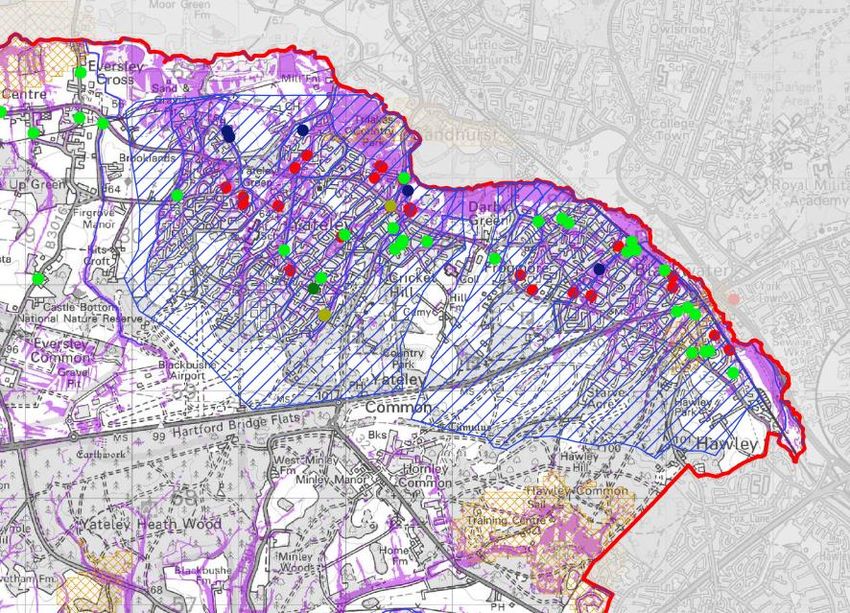
CONTENTS

Section 1        Introduction

Section 2        About Yateley Parish

Section 3        Policy Context

Section 4        Community Engagement

Section 5        Vision and Objectives

Section 6        Policies

Sustainable Development

Policy YDFNP1    Sustainable Development

Policy YDFNP2    Climate Change

Natural Environment

Policy YDFNP3    Biodiversity

Built and Historic Environment

Policy YDFNP4    Design Principles

Policy YDFNP5    Yateley Village

Policy YDFNP6    Development affecting Conservation Areas

Policy YDFNP7    Views

Infrastructure

Policy YDFNP8    Green Infrastructure

Policy YDFNP9    Local Greenspaces

Policy YDFNP10 Flood Risk

Policy YDFNP11 Community Facilities

Policy YDFNP12 Telecommunications

Housing

Policy YDFNP13 Housing Mix and Affordable Housing

Employment

Policy YDFNP14 Blackbushe Airport

Policy YDFNP15   Home Working

                                                    3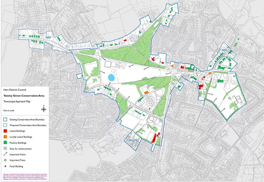
Transport

Policy YDFNP16 Active Travel

Section 7          Monitoring and Review

Section 8          Community Ambitions

Appendices

1       Glossary

2       Views

3       Local Green Spaces

4       Flooding

5       Dry Island Maps

6       Causal Area Betterment features

7       Community Facilities

                                           4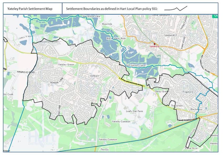
1      INTRODUCTION

PURPOSE OF THE NEIGHBOURHOOD PLAN

1       This document is a Draft Yateley, Darby Green and Frogmore Neighbourhood
Plan (YDFNP). Its preparation has been led by a Steering Group made up of local
volunteers reporting to Yateley Town Council as the responsible body for preparing a
neighbourhood plan for the Parish. A neighbourhood plan sets out a locally distinct
policy framework for planning decisions in the Parish, allowing local people to influence
what type of development they would like to see in their neighbourhood. The
Neighbourhood Plan policies are designed to protect the special character of Yateley,
Darby Green and Frogmore and encourage development proposals that benefit the local
community. The Plan is supported by a range of evidence which can be found on the
Neighbourhood Plan website at https://ydf-np.org.uk.

2       The Neighbourhood Plan forms the third layer of planning policy with the
National Planning Policy Framework (NPPF) forming the first, and the second being the
Hart District Local Plan which was adopted in April 2020. The purpose of the planning
system is to contribute to the achievement of Sustainable Development which has 3
objectives – economic, social and environmental (NPPF paragraph 7).

THE NEIGHBOURHOOD AREA

3      The Yateley, Darby Green and Frogmore Neighbourhood Plan is being prepared by
Yateley Town Council which is a qualifying body as defined by the Localism Act 2011.
Following consultation, the whole of Yateley Parish as shown on Map 1 was designated by
Hart District Council (HDC) as the Neighbourhood Area on 5 April 2018.

Map 1: Yateley Parish and Neighbourhood Area

                                              5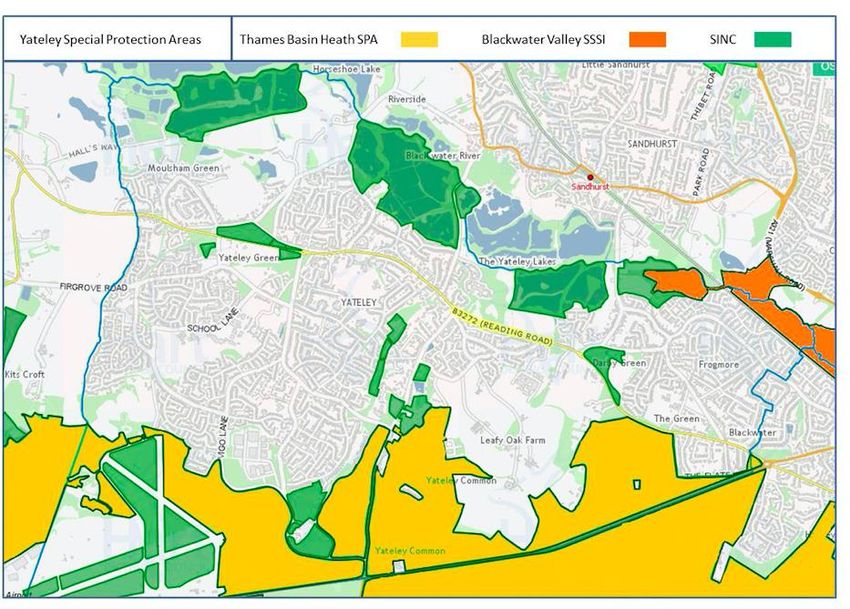
4       The policies within this Plan, once approved and adopted, will become part of the
overall Development Plan for Hart District and when any planning application for major or
minor development in the Parish is submitted, it will be assessed against the policies of this
Neighbourhood Plan.

5       The Neighbourhood Plan covers the period 2020 – 2032 which reflects the end date
of the adopted Hart Local Plan 2014 - 2032: Strategy and Sites. The content of the Plan has
been drafted to reflect the priorities of the local community, as well as national and local
planning policy.

6      Neighbourhood Plans MUST meet all of the following ‘basic conditions’ as set out in
Paragraph 8(2) of Schedule 4B to the Town and Country Planning Act 1990 (as amended).
These are:

   •   Have regard to national policies and advice contained in guidance issued by the
       Secretary of State;
   •   That the plan contributes to sustainable development;
   •   Be in general conformity with the strategic policies contained in the development
       plan for the area of the authority (or any part of that area);
   •   Be compatible with European Union (EU) and European Convention on Human
       Rights (ECHR) obligations; and
   •   Not breach the requirement of Chapter 8 of Part 6 of the Conservation of Habitat
       and Species Regulations 2017.

7       In addition to meeting the above ‘conditions’ the Town Council must be able to show
that it has properly consulted local people and other relevant organisations during its
preparation and has followed the appropriate Regulations.

8      The process of preparing the Neighbourhood Plan has identified a number of other
community priorities which are not specifically related to issues that can be included in the
Neighbourhood Plan. These are identified as ‘Community Ambitions’ in Section 8 of this Plan
and will be considered outside of the Neighbourhood Plan process.

9       Our Neighbourhood Plan does not seek to allocate specific sites for housing. The Hart
Local Plan has identified how it will meet housing needs in the District up to 2032 and does
not identify the need for additional sites to be allocated in Yateley Parish. However, it does
assume a number of ‘unidentified’ or ‘windfall’ sites will come forward from across the
District, including Yateley Parish, to help meet the overall housing requirement. This
Neighbourhood Plan therefore sets out detailed local policies against which any future
applications for new homes, including through redevelopments, will be considered, including
matters of design, energy efficiency, gains in biodiversity and the provision of affordable
housing.

                                              6
10      As set out in Section 7 the Plan will be monitored and a review may be needed if the
District Council prepares a new Local Plan, or due to other factors such as changes to national
planning legislation and policy.

WHAT HAPPENS NEXT?

11     This version of the Plan is available for public consultation between 10th March and
21 June 2021.

12     Following this, the Neighbourhood Plan Steering Group and Yateley Town Council will
consider the comments received and make any changes to the Plan that are considered
necessary. Yateley Town Council will then formally submit the Plan to Hart District Council
(HDC). The next steps are then:

    •   HDC will undertake a further statutory 6 week consultation on the submitted Plan;
    •   HDC will appoint an independent Examiner to examine the Plan;
    •   The Examiner will consider the Plan and any representations and issue a Report setting
        out any recommended changes;
    •   HDC will consider the recommended changes and agree whether to send the Plan as
        modified to a local referendum;
    •   HDC will arrange a local referendum where those eligible to vote in the Parish will be
        asked if they want HDC to use the Plan to determine planning applications in the
        Parish;
    •   Assuming that more than 50% of those who vote, vote in favour of the Plan being used
        then HDC will adopt the Neighbourhood Plan as part of the Hart Development Plan
        for the purposes of determining planning applications in the Parish.

2       ABOUT YATELEY PARISH

13      The name ‘Yateley’ appears to be derived from the Anglo-Saxon ‘yat’ (gate) and ‘ley’
(forest clearing). The earliest evidence for human activity in Yateley was provided by the
discovery of a concentration of knapped flints on Yateley Common, dating to the Mesolithic
period. Burial urns of early Bronze Age settlers have been also found on the river terraces to
the north of Yateley Green, at Hillfield and at Quarry Lane and close to Minley Manor. Much
later, evidence for pre-Conquest occupation is provided by the survival of Saxon place names
and, most significantly, the Saxon north wall of St Peter’s Church.

14     Yateley had a stone church in Saxon times and became one of the biggest settlements
in north east Hampshire in the Middle Ages. The Parish included Blackwater, Hawley,
Southwood, Bramshot, Cove and Minley and at this time was part of the Manor and Hundred

                                              7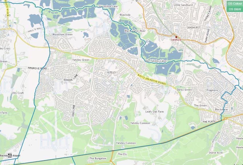
of Crondall which provided financial support for the monks of the old Monastery in
Winchester.
15 In 1334, when a national tax was levied, Yateley returned the highest tax within
Crondall Hundred, equal to the tax levied in Leeds. Some of this wealth may have come from
income derived from its location close to what is now the A30, the historic route from London
to Salisbury and the West Country beyond. St Peter’s Church facing Church End Green in
Yateley village was enlarged in the late medieval period and was partly rebuilt following a fire
in 1979. A medieval mill is recorded on the river Blackwater.
16 In the nineteenth century Yateley began to change more rapidly. With the
establishment of the Royal Military College in Sandhurst in 1812 the College staff and retired
army officers began to settle in Yateley, starting its ‘suburbanisation’. In 1942, when a major
new airfield was built on Yateley Common at Hartfordbridge, most of the farmland in western
Yateley was covered in an encampment of huts for the RAF – which on closing at the end of
WW2 were used for squatter housing. When the time came to move these residents on, land
owned by Yateley Manor was sold for new development. Despite this expansion the
population of Yateley was only 4,469 in 1961 but in 2011 had reached 20,471. Yateley now is
part of the wider ‘Blackwater Valley’ conurbation straddling the borders of Hampshire,
Berkshire, and Surrey, whose towns like Aldershot, Camberley, Farnborough, Farnham, Fleet
and Sandhurst together make it the 29th largest built-up area in England and Wales.
Yateley today
17 The Parish consists of three distinct communities – Yateley, Darby Green and
Frogmore all focused around large ‘greens’. The B3272 road (Reading Road) provides an
important and busy traffic route running from east to west through the Parish. Whilst some
of this traffic is local in origin, much of it is using this route to access nearby towns, the A30
or the M3. The commercial and civic centre of Yateley is spread along this route partly
within the Yateley Green Conservation Area and partly to its east. In the east, Reading Road
is joined by Cricket Hill Lane, which runs southwards to the A30 through the Cricket Hill
Conservation Area and which is itself a short-cut for heavy traffic, including HGVs, from
nearby Berkshire towns to junction 4A of the M3. Despite its size, public transport in the
parish is limited, with the nearest railway station at Blackwater, and just one bus service to
Camberley. Although it is the second largest town in the District, Yateley has no public
transport links to the largest town in the District, Fleet, nor the two nearest stations on the
mainline into London Waterloo, Fleet and Farnborough.
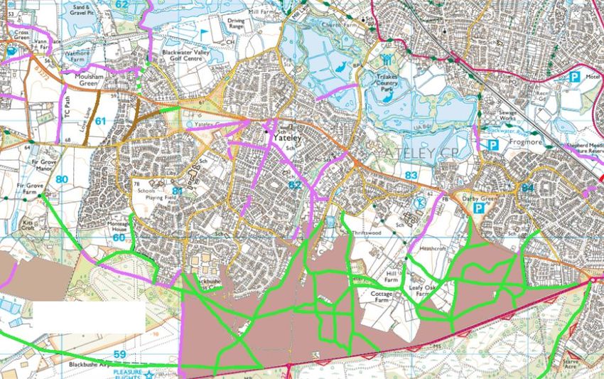
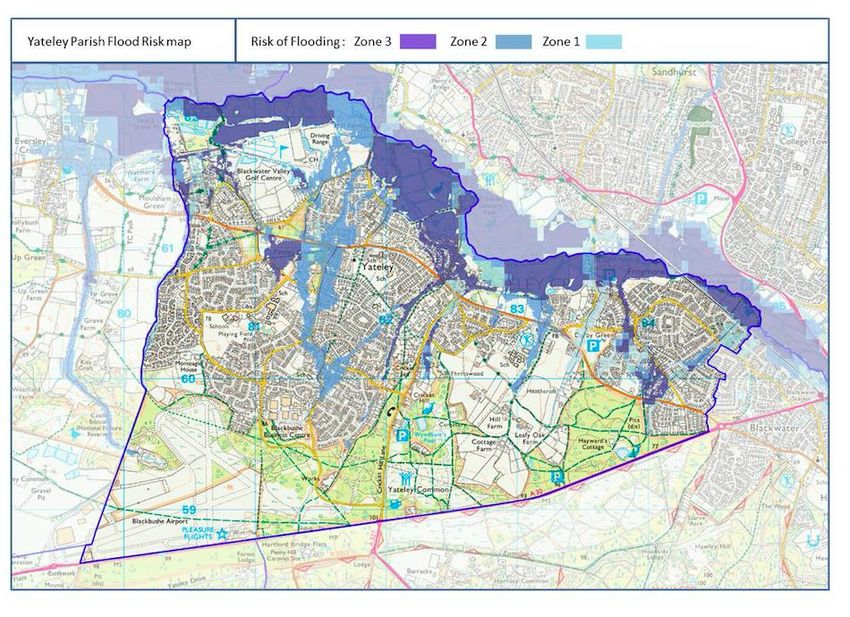
18 Yateley is bordered on the north by the Blackwater River and in the west by the Parish
of Eversley. It is heavily constrained to the north and east due to flood risk with a proportion
of the Parish lying within flood zones 2 and 3, and to the south and southwest due to the
Thames Basin Heaths Special Protection Area (SPA) as well as other important ecological
designations (see Map 2). The SPA provides a habitat for the internationally important bird
8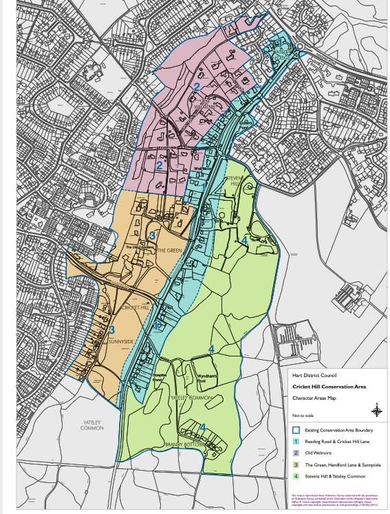
species of Dartford warbler, nightjar, and woodlark. These birds are particularly subject to
disturbance from walkers, dogs, and cat predation because they nest on or near the ground.

Map 2: Ecological Designations in Yateley Parish

19     The Parish contains many extensive areas of public and semi-public open space (such
as parks and school playing fields), which form a band running from south west to north.
These include substantial wooded blocks as well as open fields and large areas of common
land. Yateley Common Country Park owned and managed by Hampshire County Council
covers 476 acres of varied grassland, ponds, woodlands and important heathland. The
Common is designated SPA and as Sites of Special Scientific Interest (SSSI) for its important
heathland habitat. Leisure facilities include Sean Devereux Park which hosts Yateley United
Football, Yateley Cricket and Blackwater Valley Golf.

20       The fisheries in Yateley including at Swan Lake Park and Tri Lakes are owned by a
variety of organisations and have extensive and varied fish stocks supplemented by the
Blackwater River. The Blackwater Valley as a whole lying along the Borders of Hampshire,
Berkshire and Surrey is maintained as an open space from the river source in Aldershot in the
South to Swallowfield in the north. The Blackwater Valley path is a 23 mile long recreational
facility running along most of the Valley.

21     There are a string of three Conservation Areas (Yateley Green, Cricket Hill and Darby
Green) in the Parish which are all centred on large areas of open or wooded green space,

                                             9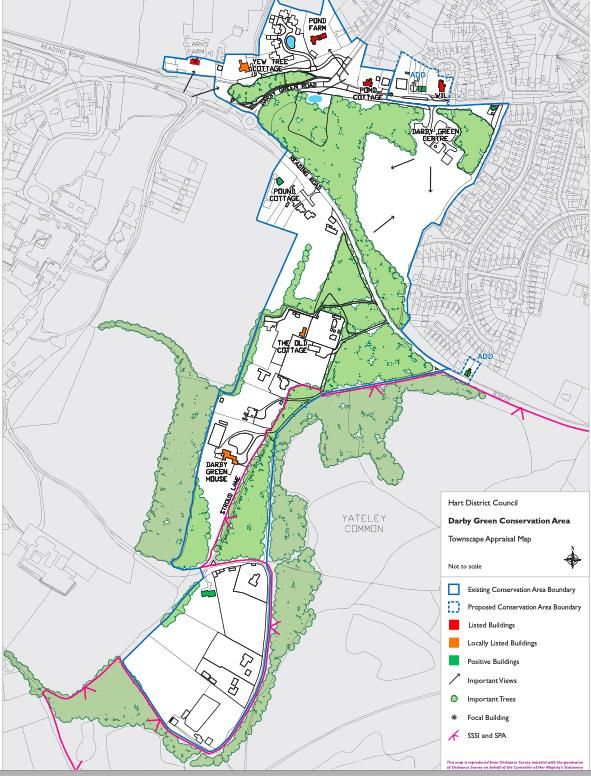
usually with very dispersed historic buildings around them. These are loosely connected by
the Reading Road (the B3272) which joins Blackwater to Eversley which passes through all
three Conservation Areas. The Parish also contains 23 statutorily Listed Buildings.

22      The Parish has a good range of community facilities including the Yateley and
Frogmore Community Centres, 3 GPs, a library, 11 schools including the District’s only sixth
form college, allotments, recreation grounds, a police station (not open to the public), fire
station and community halls. Yateley Town Council manage most of the open spaces in
Yateley. There is a strong community spirit with a number of events taking place in the
Parish including Gig on the Green, May Fayre, Xmas Market, Fireworks Fiesta, Yateley Road
Race. There are also a host of local clubs and societies.

Demographics

23      The demographic information below is taken from the 2011 Census and is set out on
Hart District Councils website. Like most of the south east the Parish has significantly higher
than average house prices and also has double the national average car ownership levels.
Hart is the least deprived local authority in England1 and no part of Yateley Parish lies within
the 30% most deprived areas.

12019 Indices of Multiple Deprivation https://www.gov.uk/government/statistics/english-indices-of-
deprivation-2019

                                                    10
3 POLICY CONTEXT
24 The Neighbourhood Plan must be prepared within the context of national and local
planning policies and guidance as well as with community engagement and on the basis of
local evidence.
NATIONAL PLANNING POLICY
25 The YDFNP must have regard to national planning policy and guidance. National
Planning Policy is set out within the National Planning Policy Framework (NPPF)2, 2019 and
this is supported by online Planning Practice Guidance which sets out more detail on
implementing national policy set out in the NPPF.
26 The NPPF sets out national planning policy on a range of issues including new homes,
employment, design, flooding, the natural and historic environment and sustainable
2 https://www.gov.uk/government/publications/national-planning-policy-framework--2
11transport. In preparing the YDFNP both the NPPF and associated guidance have helped inform
policies as has other national policy and guidance including on the environment, climate
change and transport.
27 At the time of preparing this Neighbourhood Plan the Government has produced a
White Paper ‘Planning for the Future’ which proposes a number of radical reforms to the
planning system. However, it is unlikely that the majority of changes will be in place in the
time frame within which the Neighbourhood Plan will be adopted.
THE LOCAL PLAN
28 Hart District Council adopted a new Local Plan in April 2020. This and saved policies
from the Hart Local Plan Replacement 1996 – 2006 contain the relevant Development Plan
policies3 that set the context for the preparation of the Neighbourhood Plan 4. In addition,
there is one adopted Supplementary Planning Document (SPD)5 which is specific to Yateley
Parish, this is the Yateley Village Design Framework SPD adopted by HDC in 2009.
29 The YDFNP must be in general conformity with the strategic policies of the
Development Plan. Hart District Council has identified the relevant strategic policies that must
be considered when preparing neighbourhood plans 6. Of particular note to the YDFNP are:
Hart Local Plan Strategy and Sites 2014 - 2032
- There is no specific housing allocation given to the Parish in Policy SS1 Spatial Strategy:
Scale and Distribution of Growth;
- Housing Policies (H1 Housing Mix and H2 Affordable Housing) set out the
requirements for the size and tenure of housing, including the provision of affordable
housing and of accessible housing;
- Blackbushe Business Park is identified as a Locally Important Employment Site under
Policy ED2: Safeguarding Employment Land and Premises to be protected for
employment uses unless specific criteria can be met;
- Yateley centre is identified as a District Centre under Policies ED4 and ED6 whereby
developments for town centre uses are encouraged where they are appropriate to the
scale, character and function of the centre;
- Policy NBE2 seeks to protect landscape character and to ensure that development
does not lead to the physical or visual coalescence of settlements;
3 https://www.hart.gov.uk/adopted-plans
4 A saved Policy in the South East Plan (NRM6) relating to the Thames Basin Heaths Special Protection Area is
also part of the Development Plan but is reflected in the more recently adopted Local Plan Policy NBE3.
5 See Glossary – Documents which add further detail to Local Plan policies.
6
https://www.hart.gov.uk/sites/default/files/4_The_Council/Policies_and_published_documents/Planning_poli
cy/Neighbourhood_planning/Strategic%20Policies%20of%20the%20Hart%20Development%20Plan%20for%20
Neighbourhood%20Planning%20Purposes%20%28September%202020%29.pdf
12- Policy NBE3 sets out the requirements for the protection of the Thames Basin Heath
Special Protection Area including the requirement for any net new dwellings within
5km of the SPA (the whole of Yateley Parish) to provide appropriate mitigation
measures;
- Policy NBE5: Managing Flood Risk sets out the policy measures to avoiding flood risk;
- Policy NBE8; Historic Environment sets out the approach to determining planning
applications that may affect heritage assets and their settings;
- Policy NBE10: Renewable and Low Carbon Energy supports proposals for the
generation of energy from renewable resources, or low carbon energy development
subject to relevant criteria being met;
- Policy INF1: Infrastructure sets out the requirements for all new development to
ensure the provision of appropriate infrastructure;
- Policy INF2: Green infrastructure sets out the need to protect and enhance green
infrastructure;
- Policy INF3: Transport supports the use of sustainable transport modes and sets out
criteria relating to issues including safety, parking and highway impact;
- Policy INF4 Open Space, Sport and Recreation facilities supports the enhancement and
provision of existing open space and sets out the requirements for new open space to
be provided alongside new development;
- Policy INF5 Community Facilities sets out the policy considerations for the protection
and enhancement of community facilities;
Saved Local Plan 1996 – 2006 Policies
- CON7: Riverine Environments – seeks to ensure that development proposals do not
have an adverse effect on the nature conservation, landscape or recreational value of
the Blackwater River (and other rivers)
- URB19: Yateley Conservation Areas – seeks to ensure that development in the three
Conservation Areas does not adversely affect their semi-rural character.
CLIMATE CHANGE
30 In October 2018, the United Nations Intergovernmental Panel on Climate Change
(IPCC) reported on the state of global warming. It warned that there are only a dozen years
for global warming to be kept to a maximum of 1.5C, beyond which even half a degree will
significantly worsen the risks of drought, floods, extreme heat and poverty for hundreds of
millions of people. It also outlined that limiting global warming to 1.5°C would require rapid,
far-reaching and unprecedented changes in all aspects of society. Since this report, increased
focus has arisen from governments and interest groups on climate change and on carbon
reduction.
31 The Climate Change Act 2008 required the UK to reduce its carbon emissions by at
least 80% by 2050. In May 2019, the Committee on Climate Change recommended a new
13emissions target for the UK: net-zero greenhouse gases by 2050. This was made a statutory
target in June through the Climate Change Act (2050 Target Amendment) Order 2019.
32 In ‘Blueprint for a safer planet’ (2009) Nicholas Stern summarised his findings of his
700 page report ‘Economics of climate change’ published in 2006. His primary conclusions
were –
• Doing nothing until the changes in climate had materialised was not possible as some
of these changes would be irreversible and could not be reversed; and
• the most effective solution was to invest now in sustainable technologies which would
reduce carbon emissions to avoid exceeding an average global temperature increase
of 2.0 C, subsequently reduced to 1.5 C
33 The NPPF identifies that the preparation and implementation of plans (including
neighbourhood plans) should contribute towards the achievement of sustainable
development. This includes meeting environmental, social and economic objectives.
Specifically, in relation to environmental objectives this should include contributing to
mitigating and adaptation to climate change, including moving to a low carbon economy.
34 In May 2019 a motion was passed by Government declaring a climate change
emergency and since then many local authorities and Town and Parish Councils have followed
suit. Yateley Town Council has recognised the importance of the need to take action to
reduce carbon emissions through both the neighbourhood plan process and other measures.
The school poster competition referred to in Section 4 of this Plan focused on climate change
and in July 2020 the Town Council set up a Yateley Climate Action Network (YCAN). The Town
Council Plan, 2020 includes a commitment to address the climate change agenda and find
ways of reducing the carbon footprint.
35 In response to questions in the 2020 Residents Survey 92% of the respondents agreed
that actions to limit climate change were needed at a local level and 75% had noticed changes
in the climate. Collectively, policies in the neighbourhood plan will support climate change
mitigation and adaptation. This includes through:
• Protecting local services and facilities and resisting change of use. This means that
access to local services is maintained, reducing the need to travel and ensuring local
communities remain sustainable;
• Protecting and enhancing multifunctional green infrastructure, which can provide
safe routes for walking and cycling, places for recreation and play, link wildlife
corridors, enhance biodiversity and make space for flood water;
• Promoting active travel and encouraging a switch away from cars for short journeys,
to walking and cycling;
• Protecting areas from flood risk and increasing resilience to flooding;
• Encouraging natural sustainable drainage features in new development;
• Ensuring all new development achieves a net gain in biodiversity and looks for
opportunities to increase connectivity of habitats;
14• Encouraging better quality design in new development, including improved energy
efficiency.
36 However, many of the actions we can take to reduce our contribution to climate
change are not delivered through planning policy, but in individual and community actions.
These will be explored by Yateley Climate Action Network.
STRATEGIC ENVIRONMENTAL ASSESSMENT AND HABITAT REGULATIONS
37 Draft neighbourhood plan proposals should be assessed to determine whether the
plan is likely to have significant environmental effects and this process is commonly referred
to as a screening opinion request. The requirements are set out in the regulations of the
Environmental Assessment of Plans and Programmes Regulations 2004.
38 In December 2020 a draft Plan was submitted to Hart District Council for a formal
screening as to whether a Strategic Environmental Assessment was required. As Yateley
Parish is also affected by the Thames Basin Heaths Special Protection Area a Habitat
Regulation Screening was also required.
39 The screening determination concluded that neither a full Strategic Environmental
Assessment or Habitat Regulation Assessment is required. This can be viewed on the
Neighbourhood Plan website at https://ydf-np.org.uk.
TOWN COUNCIL PLAN
40 In November 2020 Yateley Town Council adopted a new Council Plan covering
projects and activities that the Town Council aims to implement or start by 2024.
41 The Town Plan has the following Vision Statement for the Parish:
“A safe and green environment where everyone in the community will have full, healthy
lives”
42 The Town Plan sets out five Strategic Priorities. The Neighbourhood Plan will play a
key role in helping to deliver two of those Priorities:
1. Promoting sustainable living, the protection of our environment and enhancing the
quality of life for our residents
2 Generating positive developments in local infrastructure to enable excellent services
for all.
154 COMMUNITY ENGAGEMENT
43 Yateley Town Council formally decided to develop a Neighbourhood
Plan in 2017 and subsequently established a Steering Group to take this
forward. The Plan has been progressed through the Steering Group and a
number of volunteer working groups as well as on-going community
engagement. A dedicated website 7 and Facebook page has also been
established to help engage and inform the local community.
44 Consultation has played a major role throughout the process, and some key stages are
summarised below and detailed further in a separate Neighbourhood Plan Interim
Consultation Statement available on the Neighbourhood Plan website.
Spring 2018 Consultation was undertaken on a draft vision and objectives. This
included a survey to all residents, flyers at public places across the
Parish and attendance at local events.
66% strongly agreed with the draft vision and 28% agreed with it.
Respondents were asked to rank their top 5 of 17 objectives with
the following having the highest response:
• Protect open spaces and waterscapes; and
• Ensure new development is supported by infrastructure
2018/2019 Topic groups made up of local community volunteers (including
those belonging to local groups such as the Yateley Society) who
gathered evidence and engaged with the wider community and
stakeholders on land use issues.
One group of residents gathered specific evidence associated with
Active Travel through qualitative community research, exhibition
and stakeholder meetings, and kept a narrative blog of their
throughout as they fed into the initial stages of building of the
neighbourhood plan.
Autumn 2019 The inner two pages of the Autumn 2019 Yateley Town Council
newsletter was devoted to explaining the purpose of the Plan and
to raise awareness.
January – March Working with local schools to promote the Neighbourhood Plan
2020 including a poster competition particularly focused around local
actions to limit climate change.
Over 1100 entries were received with the best entries in each year
group awarded a certificate presented at school assemblies. Two
public exhibitions of these posters were held – on February 29 at
7 https://ydf-np.org.uk
16Yateley Secondary School when the Mayor of Yateley launched the
Neighbourhood Plan Resident Survey and on March 14 at the Darby
Green Community Centre. Some 300 people viewed the exhibits.
February – April A Residents’ survey was delivered to each household in the Parish in
2020 February 2020 seeking views on specific policy options which were
set out in the initial draft of the Neighbourhood Plan and Annexe
which had been previously uploaded to the YDFNP Neighbourhood
Plan website (https://ydf-np.org.uk).
Copies were also available at locations throughout the Parish and
Steering Group members were available at the launch to answer
questions.
The outcome of this consultation has informed the content and
wording of this Pre-Submission Plan.
September 2020 – Ongoing meetings and input from the Volunteer Group.
March 2021 Engagement with local stakeholders including the Yateley Society,
Blackbushe Airport and Blackwater Valley Countryside Partnership.
May – June 2021 THIS STAGE - Extensive consultation with residents and other
stakeholders on a draft Plan.
5 VISION AND OBJECTIVES
45 Following consultation in 2018 and 2020 the following Vision has been
expressed for the Neighbourhood Plan Area. The Vision sets out what the
Community wish the Parish to be like by 2032. It is based on the key issues
raised by the engagement with residents on the YDFNP and through its other
activities. The Vision helps shape the objectives and policies set out in the YDFNP.
1746 The Vision for Yateley, Darby Green and Frogmore will be delivered through the
following Objectives:
Objectives
A To ensure housing, including affordable housing is delivered that meets the
needs of the whole community
B To ensure development is supported by upgrading infrastructure including digital
broadband, local generation of electricity and initiating the transition to low
carbon heating
C To ensure new development is of an appropriate type, size, density and quality
that contributes to the community’s needs
D To ensure development is built, designed and located so as to not to add to the
carbon burden and supports the national target of net zero greenhouse gas
emissions by 2050
E To protect and enhance biodiversity, open spaces and waterscapes
F To encourage better facilities for young people
G To protect the character and identity of local communities
186 POLICIES
47 The following section sets out the YDFNP planning policies against which planning
applications in the Parish will be determined once the Plan is adopted by Hart District
Council.
SUSTAINABLE DEVELOPMENT
DELIVERING SUSTAINABLE DEVELOPMENT
48 In order to deliver sustainable development, new development will be focused within
the defined settlement boundaries as defined in the Hart Local Plan and indicated on Map 3
below. Outside of the settlement boundaries much of the Parish is constrained by areas of
flood risk and of high ecological designations.
Map 3: Yateley Parish Settlement Boundaries
49 For Yateley Parish other key elements of sustainable development relate to avoiding
flood risk, to enhancing opportunities for active travel, ensuring that appropriate
infrastructure is provided alongside new development and ensuring that affordable housing
is provided on qualifying developments. The delivery of measures to reduce any contribution
to the carbon burden and to support climate change measures being undertaken in other
19parts of the Town Council work is also an important element of sustainable development in
the Parish.
50 In order to maintain the distinctive identity of settlements, development outside of
the settlement boundaries should be consistent with Local Plan Policy NBE2: Landscape. In
the context of the neighbourhood plan area this relates to the separation of Yateley and
Sandhurst in the north and between Yateley and Darby Green. There is also community
support for ensuring the protection of the separate identities of Yateley with Eversley
although the open space between these settlements lies outside of the neighbourhood plan
area and is not therefore subject to the policies in this Plan.
Policy YDFNP1 – Delivering Sustainable Development
Development in the Neighbourhood Area will be supported within the settlement
boundaries as defined on the Hart Local Plan Policies Map. Outside the settlement
boundaries, development will not be supported unless it is in accordance with other
Development Plan policies including those in the adopted Hart Local Plan relating to
appropriate uses in the countryside and to the avoidance of the visual and physical
coalescence of settlements.
Residential development proposals within the settlement boundary will be supported
subject to proposals being well designed, and meeting all relevant requirements set out
in other Development Plan policies including:
- The provision of appropriate mitigation measures with regards to the Thames
Basin Heaths Special Protection Area in accordance with Local Plan Policy NBE3;
and
- The provision of appropriate infrastructure; and
- The efficient and effective use of land; and
- The delivery of affordable homes; and
- Support for active travel, involving physical activity such as walking and cycling
where inclusive access for pedestrians, cyclists and public transport users is
prioritised over private car use in the movement hierarchy; and
- The avoidance of development in areas at risk of flooding; and
- Preserving or enhancement of the significance of heritage assets and their
settings; and
- Improvements to biodiversity.
Development proposals should be designed in a way that reduces greenhouse gas
emission, and as appropriate, creates local generation of electricity and concentration
of geothermal heat, incorporates energy and water efficiency measures and
incorporates climate change adaptation and mitigation measures.
Development that delivers an increase in jobs will be supported subject to compliance
with other Development Plan policies.
20CLIMATE CHANGE
51 As set out in Section 3, national policy sets out that plans should include contributing
to mitigating and adaptation to climate change, including moving to a low carbon economy.
A number of policies collectively in this Plan, together with those in the Local Plan, deliver
climate change adaptation and mitigation measures including policies on flooding, on
biodiversity, on green infrastructure, local generation of electricity and heat, homeworking
and on active travel.
52 To mitigate emissions that worsen climate change it is important that buildings in the
Neighbourhood Area minimise energy use and maximise energy efficiency and the production
and use of renewable energy to meet their needs.
53 The government’s 2019 Spring Statement introduced a commitment to a “Future
Homes Standard, mandating the end of fossil-fuel heating systems in all new houses from
2025” and there has been further consultation on upgraded building regulations standards.
54 The Residents’ Survey showed that 93% of respondents approved the local generation
of electricity and heat. 10% of respondents currently have installed solar panels and a further
25% requested more information. Local generation avoids the associated transmission and
distribution losses involved in transmitting energy over long distances. As the cost of
installing solar panels has decreased by a factor of 4 in the past decade and is likely to reduce
further, development providing solar panels or the opportunity to fit solar panels will be
supported.
55 Moreover, the phasing out of gas as a heating medium from 2025 onwards will require
conversion of existing heating systems to low carbon of which the most efficient is ground
source heat pumps which concentrate the geothermal heat located in the upper 200m of the
surface.
56 Yateley is underlain by superficial deposits alongside the Blackwater River in the north
(river terrace deposits and alluvium) over Eocene age bedrock comprising mainly sands,
consisting at surface Camberley Sand Formation (south), Windlesham Formation (central
area) and Bagshot Formation (north-west). Beneath these formations is a layer of up to 100m
of London clay and beneath the clay layer is chalk. These formations are very suitable for
extracting geothermal heat.
57 The design and construction of new development which will not increase the
environmental burden is a critical part of delivering sustainable development. Proposals for
development will be expected to minimise the use of resources, mitigate against and be
resilient to the impacts of climate change. The UK 10 point Energy Plan together with the
21Committee for Climate Change’s 6th Carbon budget, delivered to Parliament on 9 December
2020, requires all buildings to be converted to low carbon heating by 2050 with the phasing
out of gas heating in new homes from 2025 and of existing heating systems from 2032. An
interim UK target has been set of installing annually 600, 000 heat pumps by 2028 with a
view to installing heat pumps in 25 million dwellings by 2050 in order to meet the UK’s zero
carbon goal.
58 For the conversion target to low carbon heating to be achieved at lowest possible
cost, it is essential that all buildings and their heating systems are prepared for the
introduction of low carbon heating when their heating systems need updating or
converting. From in depth studies by Nadia Mohammed (MSc thesis, University of Reading,
2015) and British Geological Survey (2015), the upper limit on heat demand of any
residential building should not exceed 5.0 kW at an outside temperature of -1 C for the
geothermal heat to be shared equitably from the underlying geothermal strata.
59 For all new developments within the time frame of this Plan, it will be necessary to
either install low carbon heating systems from 2025 onwards and prior to this time to ensure
that conversion to low carbon systems is possible. To ensure that the carbon burden is not
increased buildings should be orientated so both solar electric and solar heated water
modules can be mounted on suitably orientated roofs.
60 Proposals for the construction of new buildings and renovations of historic buildings
will be encouraged to conform to current Home Quality Mark (Building Research
Establishment) 8 best practice standards with respect to siting, energy, construction materials,
performance in extreme weather, transport and amenity, quality of living space and
environmental impact.
61 All developments should minimise energy use and maximise the proportion of energy
used from renewable sources. Development should consume significantly less non-renewable
energy than the development it replaces.
Policy YDFNP2 Limiting Climate Change
Development will be supported where it contributes to mitigating and adapting to the
impacts of climate change and achieves a high level of sustainable design. As
appropriate to their scale, nature and location developments will be supported where
they consume less non-renewable energy than the development it replaces and:
8 Further information at https://www.homequalitymark.com – the HQM provides impartial information from
independent experts on a new home’s quality and sustainability.
22a. can demonstrate that they incorporate current best practice in energy
conservation;
b. avoids fossil fuel-based heating systems;
c. reduces energy usage by orientation of the building(s) to optimise passive solar
gain; and, in combination with shading, to mitigate the impact of overheating;
d. generates renewable energy through solar panels, ground and air source heat
pumps, biomass, or other measures appropriate to the site;
e. moderates external temperatures and reduces CO2 in the atmosphere through
the use of green walls and roofs, tree planting and landscaping;
f. makes provision for greywater/rainwater and/or surface water harvesting and
recycling;
g. provides charging points for electric vehicles, either attached to individual units
or in communal arrangement, and in compliance with any standards set
nationally or adopted by Hart District Council;
h. reduces waste during the construction process and after occupation;
i. Provides for the introduction of low carbon heating if not installed upon
construction with low carbon heating being obligatory from 2025 onwards.
New development will be supported which delivers a high level of energy
efficiency by:
j. Exceeding the target emission rate of the most up to date Building Regulations
for dwellings;
k. Meeting the relevant design category of Buildings Research Establishment
BREEAM building standard ‘excellent’ for non-residential development.
Alterations to existing buildings should be designed with energy reduction in mind and
comply with current sustainable design and construction standards.
The retrofitting of heritage properties/assets to reduce energy demand and to generate
renewable energy will be supported where appropriate, providing it safeguards the
integrity and character of the heritage asset concerned.
NATURAL ENVIRONMENT
BIODIVERSITY
62 Life on earth has evolved over hundreds of millions of years with the evolution of
myriad species which has led to the life forms that exist today. The natural diversity within
and between species have created biological resources which feed and clothe us and provide
housing, medicines and spiritual nourishment. Biodiversity is not just confined to identified
and protected sites.
63 Over the last 50 years, there has been a decline in a number of species, which has
resulted in many cases of local extinction, linked largely to loss of habitat. The causative
23factors behind this loss of natural habitat and species include climate change, the expansion
of the built environment and the way important habitats are managed.
64 In the 2020 Residents’ Survey, 72% of the respondents had observed a decline in
species. In view of the decline in a number of species, linked largely to loss of habitat, it is
therefore important to conserve and enhance natural habitats in order to sustain ecosystems
which will protect individual species. It is therefore essential to ensure that any new
development minimises its impacts as fully as possible and provides opportunities to achieve
net gains in biodiversity.
65 The NPPF section 109 states “the planning system should contribute to and enhance
the natural and local environment by minimising impacts on biodiversity and providing net
gains in biodiversity wherever possible”. The Environment Bill 2019 – 20 provides for the
creation of a new biodiversity net gain requirement. Local Plan Policy NBE4 Biodiversity sets
out the approach to conserving and enhancing biodiversity across the District and will be used
in the determination of planning applications in the Parish along with Policy YDFNP 4 below.
66 There are a number of protective designations within and just beyond the Parish that
are of international, national and local significance (See Map 2). These include the Thames
Basin Heaths Special Protection Area (SPA), two Sites of Special Scientific Interest (SSSI) and
a number of Sites of Importance for Nature Conservation (SINC). These are detailed in a
Biodiversity Background Paper supporting this Plan.
67 The SPA was designated on 9 March 2005, as part of the Europe-wide Natura 2000
network and comprises predominantly lowland heathland and woodland. The SPA is
designated because of the presence of breeding populations of three bird species: Dartford
Warbler, Woodlark and Nightjar. These birds nest on or near the ground and as a result are
vulnerable to predators, as well as to disturbance from informal recreational use, such as
walking and dog walking. The SPA extends over all or part of 11 LPAs in Surrey, Berkshire and
Hampshire and comprises a network of 13 SSSIs.
68 The identified avoidance strategy to ensure no adverse effect on the integrity of the
SPA from new residential development is by mitigation in the form of Suitable Alternative
Natural Greenspace (SANG) and the funding of access management and monitoring
measures. The purpose of SANGs is to divert potential new users away from the SPA but they
can in themselves have biodiversity value.
69 Appropriate mitigation is required for all net new dwellings within 5km of the SPA
which includes the whole of Yateley Parish. These mitigation measures are agreed by all
authorities affected by the TBHSPA and are set out in detail in Policy NBE3: Thames Basin
Heaths SPA of the adopted Hart Local Plan, and referenced in Policy YDFNP 1 of this Plan. The
delivery of SANGs is also covered further in Policy YDFNP 8.
2470 In addition to designated sites, many other sites including gardens, trees, open spaces
and parks do, and have the opportunity to, provide important habitats. In response to early
community consultations there was strong support for additional wildflower planting and
other measures to improve biodiversity in the Parish. These issues are set out in the
‘Community Ambitions’ section of this Plan and are also being considered through the Town
Councils Yateley Climate Action Network (YCAN).
71 Policy YDFNP2 also recognises the value of trees in the Parish. Trees are important for
visual amenity, biodiversity and in some locations to provide urban shading. Any loss of
significant trees should be replaced and additional tree planting in the Parish will also be
supported in appropriate locations. New trees and landscaping should be of appropriate
native species.
Policy YDFNP3: Promoting Biodiversity
Development proposals should demonstrate a net gain in biodiversity appropriate to the
scale of the development and in line with any statutory requirements. The priority should
be to demonstrate net-gain improvements on-site.
Landscaping proposals on new development should be project specific with species
selection according to the site conditions to maximise biodiversity, aesthetic value and
health benefits. Artificial turf will not be accepted within landscaping schemes or as part
of surface cover within the development.
New development should protect trees from damage or loss and be designed so as to
minimise tree loss. Where trees must be lost as a result of development or for safety
reasons, these must be replaced at a minimum ratio of 1:1 within the vicinity of the lost
tree and of a species appropriate to the area.
Development proposals should make provision for the care and protection of existing
trees and hedgerows to be retained prior to, during and after the construction process,
including measures for the long term management and maintenance of existing and new
trees and landscaping.
BUILT AND HISTORIC ENVIRONMENT
DESIGN
72 The NPPF para 124 states that ‘Good design is a key aspect of sustainable
development, creates better places in which to live and work and helps make development
acceptable to communities’. The Town Council fully endorses this statement and believes that
25all development should demonstrate high quality and compatibility with the area, whilst
embracing sustainability principles. In the Planning for the Future White Paper, August 2020
the Government proposed that there should be a greater statutory emphasis on good design
with an expectation that new development would be beautiful and to create a ‘net gain’ not
just ‘no net harm’.
73 Yateley Parish has a mix of development ages, styles and materials and community
engagement has shown that the design of new development is important to local residents.
In the Spring 2020 survey 97% of respondents agreed that good local design should be
promoted. Examples given by residents as to what constitutes good design included:
• Development in keeping with the surroundings that reflects the local area
• Range of sizes to reflect needs
• Affordable
• In keeping with older properties
• Space between buildings
• Matching surroundings
• Adequate gardens and open space
• Low rise buildings/no more than two storey
• Sustainable/green design and use of materials/carbon neutral
• Low impact on the environment/blends with nature
• Heating systems which are either low carbon or can be readily converted as gas is
phased out as a heating medium from 2025 onwards
74 It is essential that new developments, whether they are for residential, commercial,
or other purposes, seek to make a positive contribution to the quality of the environment and
contribute positively to their overall surroundings. Whether new development is in a
traditional style or is more modern; it is the quality of design, use of materials, scale, density
and landscape details that is important.
75 Adopted Local Plan Policy NBE9: Design sets out a range of design criteria that would
be used in the determination of any applications. The intention of the YDFNP design policies
is to reinforce and strengthen the provisions of the Hart LP regarding design and to use the
guidance set out in the Hart Urban Characterisation Study and the Yateley Village Design
Framework Supplementary Planning Document to make it easier to decide whether planning
applications comply with local design priorities. The design of new development should also
be considered in relation to Policy YDFNP2: Climate Change.
Hart Urban Characterisation Study (Hart UCS)
76 The Hart Urban Characterisation Study was prepared by Hart District Council in 2010.
It was subject to public consultation when it was prepared. It divides the part of the Parish
that is covered by the Study into individual Character Areas as shown on the Maps below.
26Map 4 – Conservation Areas and Character Area Boundaries
77 Each of these areas is further subdivided into specific areas with a design analysis
and design guidance provided for each sub area.
Map 5: North Blackwater Character Area
Map 6: South Yateley Character Area
Map 7 – East Yateley Character Area
Map 8 - West Yateley Character Area
Yateley Village Design Framework SPD (YVDF)
78 The Yateley Village Design Framework was adopted by Hart District Council as
Supplementary Planning Guidance in 2009. It sets out design guidance covering Yateley village
centre and was prepared to meet the following three objectives:
• To serve as a framework to guide future development in Yateley centre;
• To establish a basis for attracting funding for environmental improvements; and
• To act as a catalyst to promote development and improvements.
2779 The YVDF SPD will remain in place but key design principles have been drawn out and
are reflected in Policy YDFNP5.
Conservation Areas
80 The Hart UCS does not cover the three Conservation Areas in the Parish (see Map 4).
Whilst the principles of good design in Policy YDFNP4 should apply within these Conservation
Areas, development must also reflect the special characteristics of those areas as set out in
the relevant Conservation Area Character Assessments/Proposals and in line with Policy
YDFNP6 of this Plan.
Design
81 The Town Council considers that the Building for a Healthy Life criteria provide a useful
basis for those considering development proposals in the Parish. These are produced by the
Design Council Cabe, the Home Builders Federation and Design for Homes and is the industry
standard for the design of new housing developments. The most recent update has also been
produced in partnership with Homes England, NHS England and NHS Improvement to ensure
the delivery of healthy places. Schemes are assessed against criteria using a traffic light
system. In addition, the Government is developing a National Model Design Code9 to support
the National Design Guide and it is important that these documents are used in influencing
design of new developments in the Parish in so far as they are consistent with the Design
policies in this Plan.
82 The Hart UCS identifies a number of areas of the Parish as having a high sensitivity to
change. These are areas with the highest townscape quality and are the most sensitive to
change through poorly designed development.
Policy YDFNP4: Design Principles in New Development
As appropriate to their scale and location, development proposals should respond
positively to local identity and distinctiveness using the Hart Urban Characterisation
Study reflecting the design guidance set out in that Study, and to the Yateley Village
Design Framework as set out in Policy YDFNP5 as well as any national or locally adopted
design codes.
In areas of high sensitivity to change identified in the Hart UCS development will be
expected to demonstrate a positive contribution to local character providing an
enhancement to the local area.
Development proposals will be supported where they:
9Available at https://www.gov.uk/government/consultations/national-planning-policy-framework-and-
national-model-design-code-consultation-proposals
28i demonstrate that as appropriate to the scale of the development, it has had
regard to the Building for Healthy Life10 criteria;
ii ensure that affordable housing is designed so that it is ‘tenure blind’ (that is,
indistinguishable from market housing);
iii include boundary treatments that reflect the character and materials of the local
vicinity;
iv reflect, respect and reinforce local architecture and historic distinctiveness;
v retain and incorporate important existing features into the development;
vi respect surrounding buildings in terms of scale, height, form and massing;
vii adopt contextually appropriate materials and details;
viii minimise the need for external lighting;
ix make sufficient provision for sustainable waste management (including facilities
for kerbside collection, waste separation and minimisation where appropriate) without
adverse impact on the street scene, the local landscape or the amenities of neighbours;
x provide adequate vehicle and cycle parking in accordance with Hart District
Council’s latest published standards;
xi integrate parking provision such that it does not dominate the street scene and
maximises opportunities for green infrastructure.
New or renovated shop fronts should, where possible, improve the character of their
local environment and complement the design of the rest of the building. The use of
lighting should be minimised to avoid light pollution.
YATELEY VILLAGE
83 The Yateley Village Design Framework SPD11 ( YVDF SPD) was adopted by Hart District
Council in 2009. The Village Centre for the purpose of this Policy stretches along the Reading
Road from Hall Lane to Cricket Hill Lane as defined in the SPD and set out in Map 9. The
Village Centre contains the main retail facilities in the Parish including a strong convenience
provision but also a range of comparison shops and other services including community
facilities. The Hart Local Plan identifies Yateley as a District Centre to which Policies ED4 and
ED6 apply and whereby developments for town centre uses are encouraged where they are
appropriate to the scale, character and function of the centre.
Map 9: Yateley Village Centre
10Available in full at https://www.udg.org.uk/publications/othermanuals/building-healthy-life
11Available at
https://www.hart.gov.uk/sites/default/files/4_The_Council/Policies_and_published_documents/Planning_poli
cy/Yateley_Village_Design_Framework%20-%20June%202009.pdf
29You can also read