ESTABLISHING THE FLOOD FORECAST CENTRE AND EXPANDING MET ÉIREANN'S RAINFALL RADAR NETWORK - establishing the flood forecast centre and ...
←
→
Page content transcription
If your browser does not render page correctly, please read the page content below
Irish National Hydrology Conference 2019                                               Sherlock and Duffy

05 - ESTABLISHING THE FLOOD FORECAST CENTRE AND EXPANDING MET
                ÉIREANN’S RAINFALL RADAR NETWORK

Eoin Sherlock1 and Sinéad Duffy1
1
  Met Éireann, 65/67 Glasnevin Hill, Dublin 9, Ireland

Abstract
The Government Decision of January 2016 called for the establishment of a National Flood Forecast
Warning Service (NFFWS). The operational element of the service was to be the Flood Forecast Centre
(FFC) in Met Éireann with guidance and standards provided by an Oversight Unit in the Office of Public
Works (OPW).

Stage 1 of the establishment of the NFFWS is centred on forecasting two types of flood; river and
coastal at a national and catchment level. In order to do this a review was undertaken of all available
fluvial models for use in an operational flood forecasting centre. A number of different models and
integrator systems were reviewed and scored via a Multi Criteria Analysis. A short list of models were
then built, calibrated and run in an operational setting for a period of time. At the end of this process
model(s) would be selected to use in the trial of the operational FFC in 2021. The models will then be
inserted into an operational environment within Met Éireann.

The OPW’s Tide and Storm Surge Forecast Model has been run by the OPW for a number of years.
The FFC and the OPW are working in transferring this system into Met Éireann’s High Performance
Computing Centre to avail of the parallel programming functionality. This will also allow the model to
be run with both Met Éireann’s Harmonie based Irish Regional Ensemble Prediction System (IREPS),
which currently runs for 30 hours and the ECMWF’s longer range EPS.

In terms of observations for the FFC, Met Éireann has recently expanded its number of climate stations
with 60 new stations installed throughout the country in 2019. These stations can report on a minute
basis and over time they will be used to recalibrate fluvial models for the FFC. There is an option for
an additional 20 climate stations in the contract and it is expected that this option will be exercised.
Met Éireann is also improving the weather radar network for Ireland. The weather radar network will
be upgraded and modernised in the coming years to enhance Met Éireann’s provision of a quality
meteorological and hydrological service to the nation. It is anticipated that the network will increase
from two radars (at Dublin Airport and Shannon Airport) to at least five radars.

A contract is due to commence soon to plan all aspects of the Irish weather radar modernisation. It will
identify the requirements, technology, locations and design for an upgraded and modernised weather
radar network. In addition, the contract will assist Met Éireann to develop a strategic plan for the
weather radar network in the long term, up to 2040.

The findings of this contract will then be used to begin the procurement and installation of the 5 new
radars in the network. It is expected that the development of the radar network will take a number of
years to complete. The additional climate stations and the expected increased radar coverage will greatly
assist in forecasting fluvial and pluvial flood events.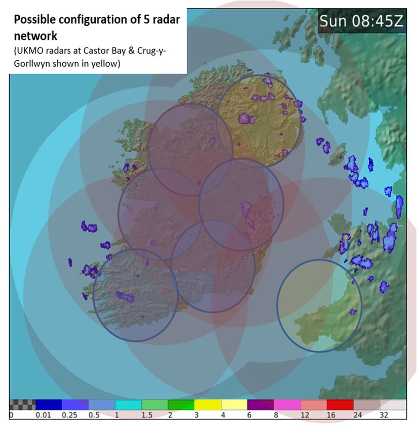
Irish National Hydrology Conference 2019                                                      Sherlock and Duffy

1. INTRODUCTION
The meteorological winter of 2015/2016 will be remembered as another exceptional winter across
Ireland, with numerous climate records broken and high impact weather events causing considerable
disruption from flooding and high winds. A succession of winter storms tracked across the country,
bringing persistent and in places recordbreaking rainfall, including the highest 24 and 48 h rainfall
accumulations on record, from storm Desmond on 4–6 December. Persistent rain, particularly through
the first half of the winter, resulted in new records for both monthly and seasonal rainfall accumulations
widely across Ireland (McCarthy et al., 2016).

It was the wettest December over Ireland in a time series from 1850, with the greatest anomalies in the
south and southwest. Five stations in counties Cork and Kerry broke the previous Irish record monthly
accumulation of 790 mm, with a new record of 943.5 mm occurring at Gernapeka, County Cork.
Impacts, especially from severe flooding, were of national significance following a number of the
weather events that contributed to these remarkable rainfall accumulations. The impact of this rainfall
was exacerbated by the already saturated ground in many areas following the high rainfall during
November. Figure 1 shows the accumulation of rainfall through the whole period for a selection of rain
gauges representing some of the worst affected areas. The significant rainfall events such as Desmond in
early December are particularly notable.

                                               Rainfall November 2015 to February 2016
                                2500

                                2000
   Rainfall accumulation (mm)

                                1500

                                                                                    Cloone Lake (LTA = 1166 mm)

                                1000                                                Keenagh Beg (LTA = 822 mm)
                                                                                    Dungarvan (LTA = 466mm)

                                500

                                  0
                                 01-Nov-15   01-Dec-15   01-Jan-16    01-Feb-16
                                                         Axis Title

Figure 1: Rainfall November 2015 to February 2016

Flooding was widespread during the winter of 2015/2016 and it was comparable to the flooding events
of November 2009. Estimated damage to the road network was over €100m (Kilgariff, 2018).
Nationally €1.8 million in humanitarian assistance was paid to affected households. A significant
number of households were affected by the flooding.

In June 2010, JBA Consulting commenced work on ‘The Strategic Review of Options for Flood
Forecasting and Warning in Ireland’. The Steering Group for the review comprised of staff from Met
Éireann, The Office of Public Works (OPW) and the County and City Managers Association (CCMA).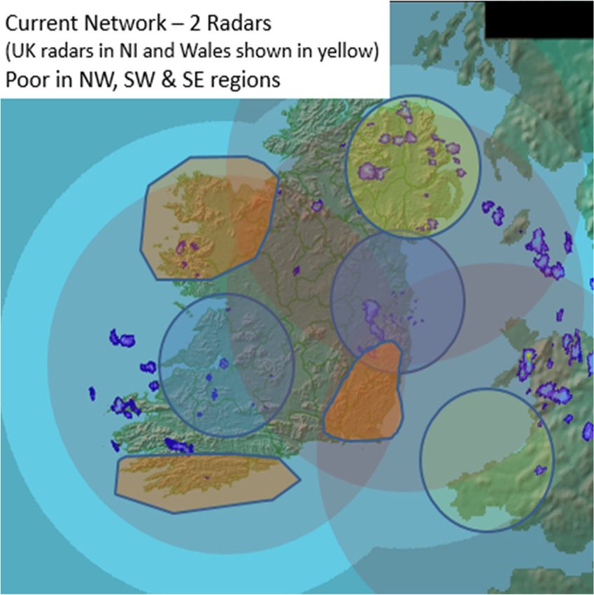
Irish National Hydrology Conference 2019                                               Sherlock and Duffy

This review was completed in late 2012 and contained a number of recommendations as to how a
National Flood Forecasting and Warning Service could be implemented in Ireland. In early 2016, the
Minister for Public Expenditure and Reform, on behalf of the Minister of State with special
responsibility for the Office of Public Works (OPW), requested the Government to agree to the
establishment of a National Flood Forecasting and Warning Service (NFFWS). The flood forecasting
service would be a new operational unit within Met Éireann with guidance for standards and
performance overseen by the Office of Public Works.

At the same time, Met Éireann had started to plan for two large capital projects. The first is the
modernisation of its weather radar network, and the second was the modernisation and expansion of its
climate network. These projects will be of enormous assistance to the nascent NFFWS.
This paper describes the development of the National Flood Forecast Warnings Service and the
establishment of the Flood Forecast Centre (FFC) within Met Éireann. It also details the current projects
to produce a strategy for Met Éireann’s rainfall radar network and the modernisation of its climate
network.

2. ESTABLISHING THE FLOOD FORECAST CENTRE

2.1 An overview of the functions of the NFFWS
The Implementation Plan for the NFFWS came out of the Strategic Review The Plan called for the
establishment of a number of different components.
The operational element of the NFFWS will be in Met Éireann and it will be named the Flood Forecast
Centre. Met Éireann has experience of running operational systems and weather forecasting operations
since 1936. An Oversight Unit in the OPW will provide Standard and Performance Guidelines to the
FFC.
An important element of the NFFWS is the development of sub-groups. These sub-groups have the
responsibility to deliver on specific tasks such as the development of a Communication Strategy for the
NFFWS.
These three sections will report to the NFFWS Steering Group, which the OPW chairs. Other
stakeholders include the Department of Housing, Planning and Local Government, Department of
Agriculture, Food and the Marine and the Local Government Management Agency. The NFFWS
Steering Group then reports to the Interdepartmental Flood Policy Coordination Group.

2.2 The Flood Forecast Centre
This paper will focus on the establishment of the Flood Forecast Centre within Met Éireann. It will
provide details on the steps that the FFC has taken to develop its capacity and capability in operational
fluvial flood forecasting at a National and Catchment level.

To inform and support the establishment of the NFFWS there was an urgent requirement to review,
develop and trial a range of existing available hydrological models for potential use in operational flood
forecasting in Ireland at both National and Catchment level. There was also an urgent need to review a
range of existing integrator systems for potential use in conjunction with these operational flood
forecasting models.

It was agreed at the NFFWS Steering Group to pursue a Contract for the Review, Development and
Trial of a Range of Hydrological Models and Integrator Systems for Use in Operational Fluvial Flood
Forecasting in Ireland. The Contract included a comprehensive literature review of a number of
hydrological models and integrator systems. The literature review recommended that four hydrological
models (HYPE, wFLOW, WRF-HYDRO and URBS) and two integrator systems (FEWS and MIKE-
Operations) should be trialled. The Contractor would build, calibrate and validate functioning
Irish National Hydrology Conference 2019                                              Sherlock and Duffy

hydrological models for five representative catchments using the four recommended hydrological
models from the Literature Review. The next step would be to trial the application of the four validated
hydrological models on the five representative catchments for operational fluvial flood forecasting
purposes. At the same time the four hydrological models would be trialled in conjunction with the two
recommended integrator systems on one of the representative catchments for operational fluvial flood
forecasting purposes.

The Contract would conclude with a Final Report outling in detail all of the findings and outcomes of
the various stages. It would provide conclusions and recommendations on the models, integrators and
ICT requirements for operational fluvial flood forecasting in Ireland.

2.3 Fluvial Modelling Contract

2.3.1 Stage 1: Literature Review
The FFC made a call to all interested parties to acquire information of available hydrological models
and integrator systems. There NFFWS requested a number of high-level requirements for the
hydrological models such as calibration, input, output, maturity etc. The models also had to be able to
run on a National and Catchment scale. The models obtained scores via a multi-criteria analysis (MCA),
based on the ten high-level requirements (Table 1).

Table 1: MCA Requirements
 Hydrological Models                                 Integrator Systems
 Model structure – suitable for Irish catchments     Modularity – coupled to hydrological model
 Output – calculate flow at all modelling points     Input/output – meet all requirements
 Input – the model can handle the available input    Efficiency – ease of use, licensing etc.
 Calibration – can be calibrated with tools          Maturity – proven stability and maturity
 Accuracy – predict peak +/- 10% in 6 hours with
 a lead time of greater than 24 hours
 Maturity – proven stability and maturity
 Computational speed – acceptable time span
 Ease of set up - set up by a trained user
 Code availability – readily available for usage
 Coupling – easily coupled to other components

2.3.2 Stage 2: Model Development for Representative Catchments
The five representative catchments are the Moy & Killala, Shannon, Nore, Barrow and the Slaney and
Wexford Harbour. For each of the catchments four hydrological models had to developed and
calibrated. Model development for an additional seven catchments is planned for early 2020. The
additional seven catchments are shaded green in Figure 2.
Irish National Hydrology Conference 2019 Sherlock and Duffy
Figure 2: Fluvial Model Catchments
A number of different data sources were used in this process and both Met Éireann and the OPW
provided these to the Contractor, International Marine and Dredging Consultants nv. The data sources
included gridded daily rainfall, rainfall radar, synoptic observations, the MÉRA reanalysis, historical
flow data, and catchment information.
The Contractors worked closely with the developers of the hydrological models and integrator systems
to overcome any obstacles. They succeeded in building 20 hydrological models, four for each of the
five catchments. A set of high flow events was used to calibrate the models. Approximately 20 events
were selected for each catchment, 10 of these are the extreme events in the period 1981 to 2016. The
remaining 10 events are less extreme events with a minimum return period of 0.5 years.
For each gauge, model performance statistics were calculated. Two of the models appear to be
performing at a higher level than the other two. HYPE and URBS scored higher than wFLOW and
WRF-HYDRO. It is important to stress that both HYPE and URBS were easier to build and calibrate
and one can expect to achieve higher scores. If additional resources are used on wFLOW and WRF-
HYDRO the user should be able to improve on the current performance statistics.
2.3.3. Stages 3 and 4: Trialling of the Hydrological Models and Integrator Systems
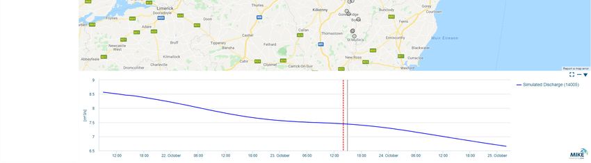
The Contract is currently at Stages 3 and 4. The four models are running in an operational setting for
the Barrow Catchment in both the FEWS and MIKE Operations integrator systems. The trial will last
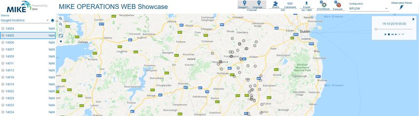
for 8 weeks. The MIKE Operations integrator system is show in Figure 3 below.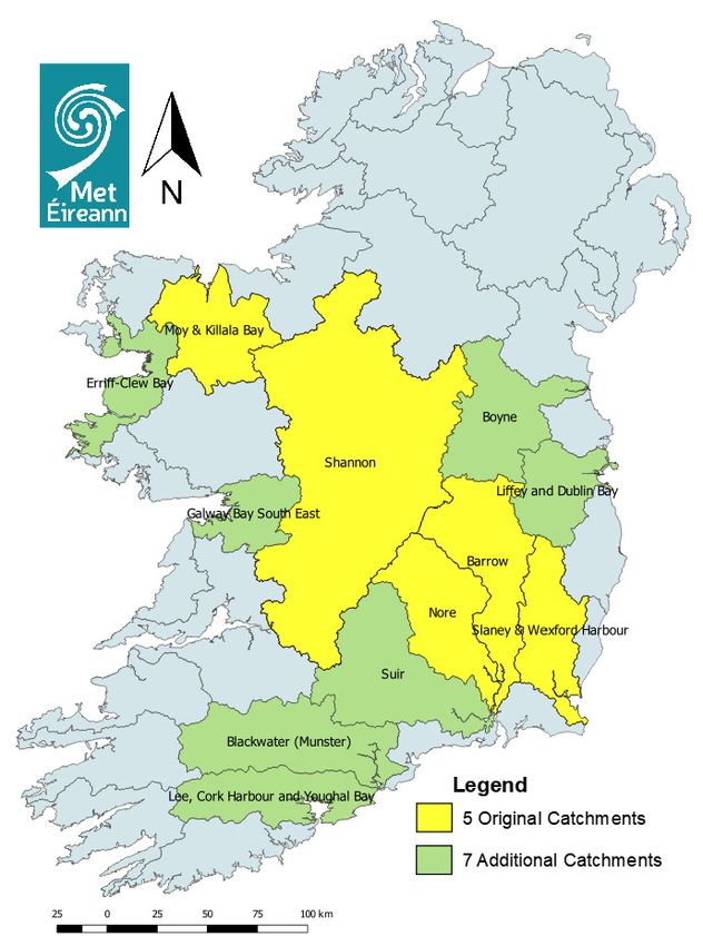
Irish National Hydrology Conference 2019                                                Sherlock and Duffy

Figure 3: MIKE Operations Integrator System

2.3.4 Final Reporting and Next Steps
The final report shall present in detail all of the findings and outcomes of each Stage of the project. It
will include conclusions and recommendations as to the modelling and other related systems to be used
for operational flood forecasting in Ireland.

Met Éireann and the OPW will examine the recommendations in the Final Report in order to arrange
for operationalising the hydrological models. A trial of the FFC will occur in Q3 of 2021. This means
that the fluvial flood forecasting models would need to be operational and coupled to an integrator
system. A dissemination system will be required to ensure that all flood alerts and advisories are sent
in a timely manner to all stakeholders.

The models will reside in an operational environment within Met Éireann that will cater for disaster
recovery and business continuity measures. This will mirror the current configuration for our Numerical
Weather Prediction (NWP) models.

2.4 Coastal Modelling
The OPW’s Tide and Storm Surge Forecast (TSSF) Service has been in operation for a number of years.
The TSSF service provides information to assist with the early alert of the potential risk of coastal
flooding at eighteen locations around the coast of Ireland, and additionally at higher resolution locations
comprising Cork Harbour, Wexford Harbour, Dundalk Bay, Galway Bay and Shannon Estuary. Figure
4 displays the TSSF’s morning summary forecast.
Irish National Hydrology Conference 2019                                              Sherlock and Duffy

Figure 4: TSSF Morning Summary Forecast

The OPW and Met Éireann are exploring a trial of running the TSSF on a High Performance Computing
platform. This trial is likely to start in early 2020.

Met Éireann is a member of the European Centre for Medium-Range Weather Forecasting (ECMWF).
As a member, Met Éireann has access to a state of the art High Performance Computing Centre (HPC).
The ECMWF’s supercomputer is a Cray, which has over 250,000 compute nodes. Access to such
computing power will enable Met Éireann to use the parallel features of the TSSF service to its benefit.
The TSSF should be able to run much quicker as the number of computational cores increases.

Another advantage of running the TSSF on a HPC will be the ability of the system to run with Ensemble
NWP forecasts. This will allow the TSSF to use Met Éireann’s Harmonie model Irish Regional
Ensemble Prediction System (IREPS), and ECMWF’s longer-range ensemble forecast data. The TSSF
service will become part of Met Éireann’s operational NWP. The NWP suite is monitored 24/7 by
operations both in Reading, UK and in Glasnevin, Dublin.

3. EXPANDING MET ÉIREANN’S RAINFALL RADAR NETWORK
Weather radars provide a steady stream of near real-time information 24 hours a day, 365 days a
year. They are used to provide information on precipitation amounts and intensities within a radius of
circa 240km. Currently there are only two weather radars in the entire state. These are maintained and
operated by Met Éireann and are located at Shannon Airport and Dublin Airport. Together they
comprise a strategic component of Ireland’s meteorological infrastructure. Data from the weather radar
is integral to the provision of services such as aviation forecasting, weather forecasting, nowcasting,
flood alerts and warnings, severe weather alerts, and is freely accessible to the public through the Met
Éireann website and apps. It is also a key tool for response to major emergency incidents (e.g.
radiological).
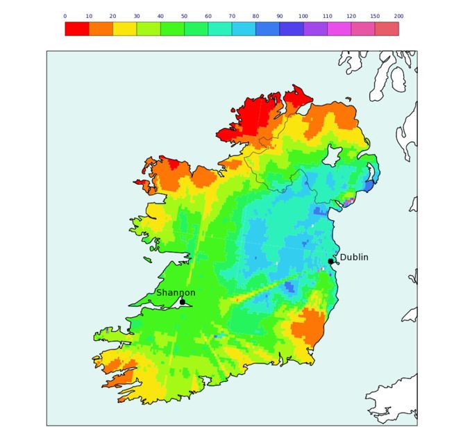
Irish National Hydrology Conference 2019                                             Sherlock and Duffy

Figure 5: Irish radar performance 2012

Figure 5 above details the total annual radar-detected rainfall expressed as a percentage of the total
annual gauge-observed rainfall (Fitzpatrick, 2013).

3.1 Radar Issues
3.1.1 The existing radar mechanical hardware is becoming obsolete
The lifespan provided by the refurbishment of both the Shannon and Dublin Radars conducted during
2010 and 2011 will be coming towards its end in the coming years.

3.1.2 Gaps in radar coverage over large areas
The present two radars provide adequate detection coverage over most of Ireland, but there are
significant gaps in the South-east, South-west and North-west, for weather and flood forecasting
purposes.

3.1.3 Poor coverage for quantification of precipitation amounts
For other uses for which weather radars can be employed, such as Quantitative Precipitation Estimation
(QPE), for hydrological purposes i.e. flood forecasting, the coverage is very poor. Best coverage is in
the Dublin and Shannon regions. Major river catchments such as the Lee, Munster Blackwater, lower
Suir, Nore, Barrow, Slaney, Upper Shannon, Upper Liffey and others are not adequately covered. For
QPE, radars are only effective to a range of 75km, which implies radars should be spaced no more than
about 120km apart. To meet this target an expansion of the existing network is required.

3.1.4 Poor detection of convective events in parts of Ireland
Detection of convective events such as thunderstorms lessens incrementally the greater the distance
from an operational radar site. The density of the existing network is insufficient to give reliable,
Irish National Hydrology Conference 2019 Sherlock and Duffy
consistent information of this high-impact convective event. This inhibits the provision of nowcasting
information for aviation, transport, public safety, agriculture etc.
3.1.5 Limited detection capability
The technology used in the current radars has limited capability to discriminate between different types
of precipitation (e.g. rain, hail snow) which, is of particular importance during extreme snow events for
example. This also limits correction for signal attenuation as well as unwanted signals from the
surrounding environment (e.g. buildings, birds etc.) – affecting overall data accuracy and reliability.
3.1.6 The locations of existing radars may no longer be optimal for future requirements
Planned developments at Dublin airport may make the site for the Dublin radar nonviable in the coming
years. The site is also subject to high levels of interference from local Radio Local Area Networks
(RLAN). For these reasons, continued operation at the present location may be significantly impaired.
Shannon radar is located at a low altitude, (25m AMSL) surrounded by rising terrain significantly
limiting the effective range of the radar due to occultation of the radar beam.
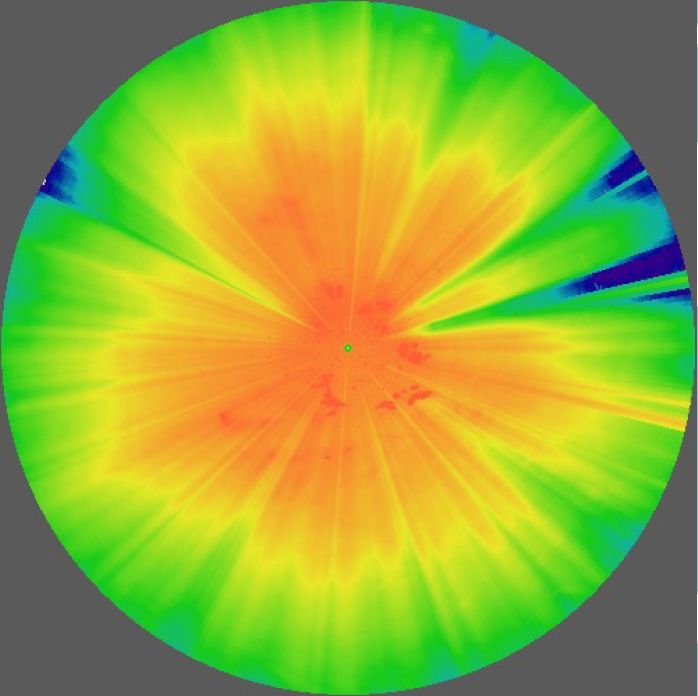
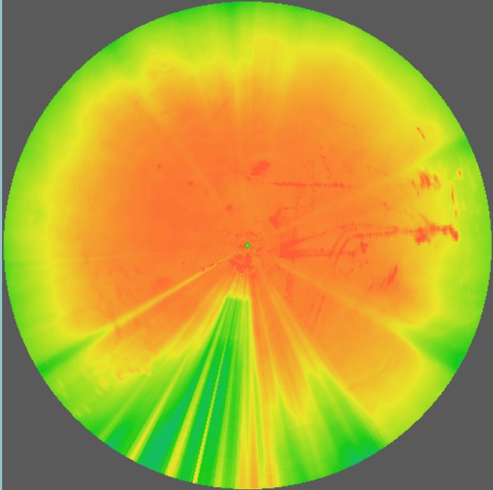
Figure 6 below shows the coverage of the Dublin and Shannon radars. The Dublin Airport radar has a
good view (Figure 6a) apart from the southeast and southwest. The Shannon radar (Figure 6b) is a low-
lying installation and is blocked by mountains.
3.2
Figure 6: (a) Dublin Airport, (b) Shannon Airport Radar
Modernised Radar Network Project
In order to address the issues raised above, Met Éireann in 2018 commenced a project to upgrade and
modernise the national weather radar network in order to enhance the quality and reliability of
meteorological and hydrological services provided to the Irish public. To assist in the planning of the
project, a procurement competition for “A Scoping Exercise on an Upgraded and Modernised Weather
Radar Network for Ireland” was undertaken in May 2019.
The aim of the Contract is to specify the radar system requirements for Ireland. The findings of the
Contract will be used to design an optimal weather radar network, including radar systems and site
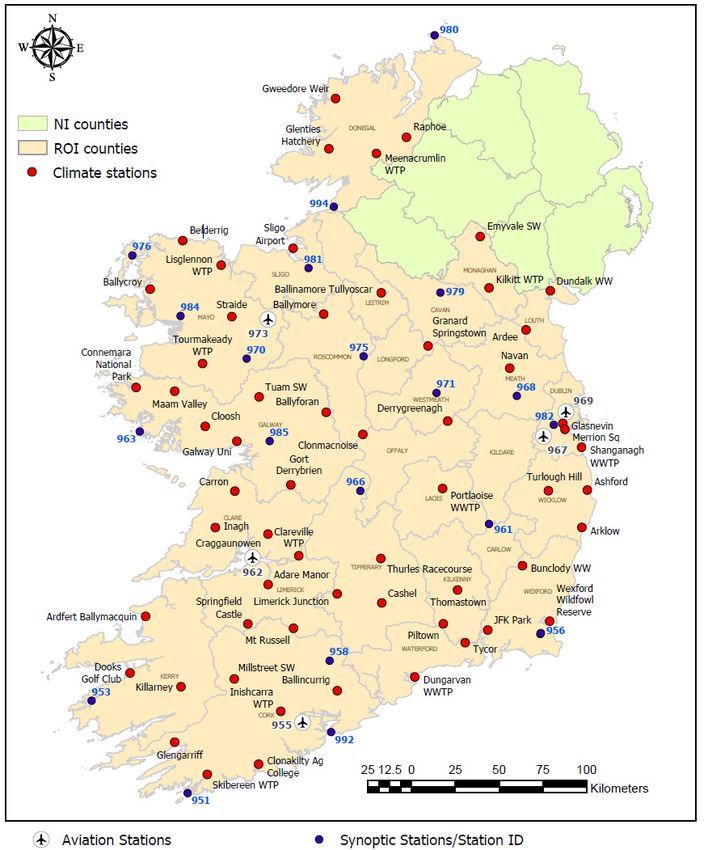
locations.Irish National Hydrology Conference 2019 Sherlock and Duffy The final element of the Contract will be to draft a plan for the implementation of the modernised weather radar network. The Contract will commence in November 2019 and it is expected that given the complexities involved it will take at least five years before the first of the five new radars is installed. The before and possible after configuration are given in Figures 7a) and b) below. Figure 7: Current and future (possible) networks 4. EXPANDING MET ÉIREANN’S CLIMATE NETWORK In terms of observations, rainfall gauges are a vital part of any flood forecasting service. Met Éireann has an extensive climate network but the data can be delayed, and the daily gridded rainfall is always one day behind. The Climate and Observations Division of Met Éireann is drawing to the end of its climate network modernisation project. This involved the supply, installation and maintenance of sixty Automatic Climate Stations (ACS). Each ACS shall consist of a data logger, sensors (including a weighing gauge precipitation sensor “Gauge”), and Stevenson screen and data transfer capabilities. This will be a welcome addition to the observation network that the FFC will use a) to calibrate its models and b) for now-casting events. Sixty ACS stations will be installed by the end of 2019 and there is an option for another 20 for 2020, which will be optioned.
Irish National Hydrology Conference 2019                                            Sherlock and Duffy

Figure 8: Locations of ACS

5. CONCLUSIONS
This paper has described how the FFC came into existence. It has detailed the governance of the
NFFWS. It also expanded on the current research of the FFC in terms of fluvial and coastal models.
Met Éireann as the Irish Meteorological Service is well placed to provide support to the FFC through
its core services such as observation network and High Performance Computing resources. The
expected improvement in the weather radar network and climate network will be of great assistance to
the refinement of fluvial models and nowcasting of pluvial events.

As a non-capital investment, Flood Forecast Centres have proven to be cost effective. A paper by
Pappenberger et al. (2015) suggests that benefits of 400 Euro are achieved for every one Euro invested
in early flood warnings in Europe.
Irish National Hydrology Conference 2019                                                 Sherlock and Duffy

The process will be lengthy. In order to develop fluvial and coastal models requires time and resources.
If the set up times of other FFCs are reviewed, it can be seen that the establishment of a service like this
can take a considerable amount of time; anytime from 15, up to 20 years.

6. ACKNOWLEDGEMENTS
It is important to acknowledge the contribution of all the members of the NFFWS Steering Group; the
OPW, County and City Management Association, National Directorate for Fire Emergency
Management, Department of Agriculture, Food and the Marine and in particular the staff of the
Hydrology and Coastal Section of the OPW. IMDC nv have carried out the model selection and
development on behalf of Met Éireann and their guidance and experience has been of great assistance,
The Technology Division in Met Éireann is providing support to the Weather Radar expansion project
and the support staff in both Shannon and Dublin Airports have helped to shape the project.

7. REFERENCES
McCarthy, M., Spillane, S. (2016). The meteorology of the exceptional winter of 2015/2016 across the
UK and Ireland. UK Met Office, Met Éireann.
Kilgariff, P (2018). The impact of flooding disruption on the spatial distribution of commuter’s income,
Teagasc.
Fitzpatrick, N. (2013). Verification of Met Éireann Weather Radar. Technical Note No. 62.
Pappenberger, F., and Cloke, H, (2015). The monetary benefit of early flood warnings in Europe,
ECMWF
You can also read