Information Brochure 8 Samoa Deep-sea Minerals Potential
←
→
Page content transcription
If your browser does not render page correctly, please read the page content below
SPC-EU EDF10 Deep Sea Minerals (DSM) Project

                                                      Information Brochure 8
                                             Samoa Deep-sea Minerals Potential

The Samoan island chain (i.e. Samoa and American Samoa) consists of high volcanic islands, atolls and
submerged reef banks, and seamounts near the southwest margin of the Pacific plate (Figure 1). The chain
trends in a south-eastern direction and the islands are unusually volcanically active on both the eastern and
western end of the chain. This has complicated known hot spot behaviours that are consistent with the
formation of intra-plate island chains such as Hawaii.
The country of Samoa is made up of the western part of the island chain including the major islands of Upolu
and Savaii (Figure 1). The country’s 120,000 square kilometre Exclusive Economic Zone (EEZ) is the smallest
in the region due to the fact that Samoa is bordered to the North by Tokelau, American Samoa to the East and
Northeast, to the South by Tonga and Wallis and Futuna to the West. The country’s EEZ boundary is displayed
in Figure 3.

Figure 1. The 2010 Google Earth satellite image of the Samoa island chain showing islands and seamounts. The yellow dotted
line roughly indicates the boundary separating Samoa (West) and American Samoa (East).
                                                                                                                             1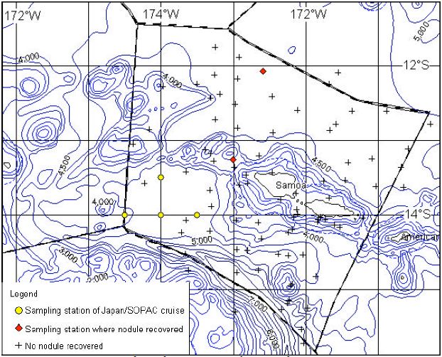
Seafloor topography of the Samoa EEZ is divided into abyssal plain, mountainous zone, and the Tonga Trench
    (Figure 2). The mountainous zone is composed of topographic high of the Samoa Islands including Savaii and
    Upolu Islands and the seamounts that occur to the western end of the island chain (Figure 2). The islands and
    seamounts are surrounded by abyssal plains.
    This information brochure highlights the early marine mineral surveys and the 1990 Japan-SOPAC study results
    within the EEZ of Samoa.

    Exploration History
                                                                                            Deep sea minerals investigation
                                                                                            in Samoa started in the late
                                                                                            1970s assessing the potential
                                                                                            for    Manganese       Nodules,
                                                                                            Phosphate, Precious Coral and
                                                                                            Cobalt-rich Crusts (CRC).

                                                                                            1990 Cobalt-rich Crusts
                                                                                            Survey
                                                                                            During the 1990 Japan-SOPAC
                                                                                            survey in Samoa, sampling of
                                                                                            Manganese Nodules and seafloor
                                                                                            photography were carried out
                                                                                            as well as CRC investigation
                                                                                            on four seamounts. Three of
                                                                                            the surveyed seamounts (i.e.
                                                                                            SD01, SD02 and SD03) belong
                                                                                            to the Samoan island line, while
                                                                                            the Machias Seamount (SD04)
                                                                                            is located at the point where
                                                                                            the Tonga Trench bends from
                                                                                            N-S direction to E-W. The FDC,
                                                                                            SBP and SSS survey methods
                                                                                            were used for the crusts survey.
                                                                                            The location of each of the four
                                                                                            surveyed seamounts is shown in
                                                                                            Figure 2.

                                                                                            1990 Manganese Nodule
                                                                                            Survey
                                                                                            Manganese Nodules survey was
                                                                                            also conducted during the 1990
                                                                                            Japan-SOPAC survey in Samoa.
                                                                                            Four      Manganese        Nodules
                                                                                            sampling stations were selected
                                                                                            in the survey area (Figure 3). Three
                                                                                            sampling points were identified in
                                                                                            each of the four stations where
                                                                                            samples were collected.
    Figure 2. Seafloor topographic map of Samoa showing the locality of major topographic
    features.

2   SPC-EU EDF10 Deep Sea Minerals Project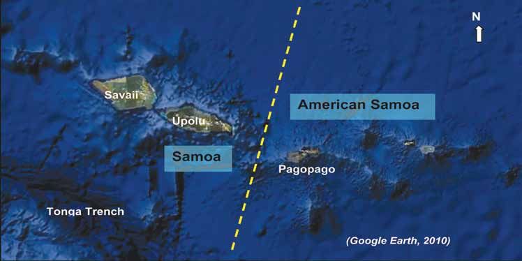
Figure 3. Location map of sampling stations in the EEZ of Samoa.

Summary of Exploration in Samoa
Previous seabed mineral investigations in Samoa are given in Table 1 below.
Table 1. Summary of previous offshore minerals exploration in Samoa.

Research Vessel and Year
of Survey                                      Survey Area                         Surveyed Commodity

RV Coriolis (1977)             Samoa’s EEZ                               Manganese Nodules
R. V. Machias (1979)           Pasco Bank West of Savaii, and shallow    Precious coral, Phosphate
                               bank northeast of Pasco Bank
R. V. Machias (1979)           Assau and Salelologa Harbours             Nearshore sediment deposits for
                                                                         construction and landfill
R. V. Machias (1979)           South (to the Tonga Trench) and west of   Precious Coral, Manganese Nodules/crust,
                               Upolu and Savaii                          Phosphate
R. V. Machias (1980)           Deeper flanks of the Samoa Island slope   Precious coral
R. V. Moana Wave (1987)        Machias Seamount, southern coast and      Cobalt-rich Crusts, metalliferous sediments,
                               western tip of Savaii;                    hydrothermal vents
R. V. Hakurei Maru 2 (1990)    Sea area of Upolu and Savaii Islands      Manganese Nodules, Cobalt-rich Crusts

                                                                            SPC-EU EDF10 Deep Sea Minerals Project      3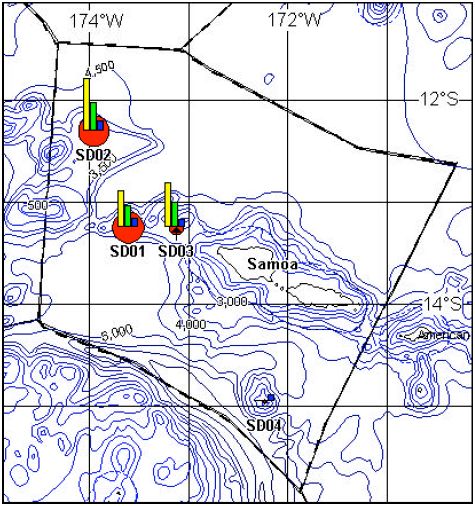
Exploration Results
    The EEZ of Samoa is reported to have moderate potential for CRC but is poor in Manganese Nodules. According
    to Lonsdale (1975), the greater part of the Samoa waters is presumed to have had its sedimentation of turbidite
    and slumping sediments ever since its formation 5 Million years ago (Ma).
    Exon (1983) and Cronan (1984, 1986) further revealed that the principal environmental conditions for the
    formation of high abundant zones of Manganese Nodules in the southwestern Pacific Ocean including the EEZ
    of Samoa, are the following three points:
       (i)   Biological productivity should be more than 50g/cm2/year.
       (ii) Water depth should be at around or deeper than the Carbonate Compensation Depth (CCD).
       (iii) Turbidite sediments, which are supplied by islands and seamounts with high sedimentation speed,
             should not exist on the seafloor.

    Within and around the EEZ of Samoa, only two out of 90 sampling stations have been registered in the
    SOPAC Deep-sea Mineral Resources database show the existence of Manganese Nodules (Figure 3). The
    grade of Manganese Nodules is presumed to be low due to the EEZ of Samoa being outside of the high
    biological production zone of the equatorial region. Furthermore, even if the upwelling from the bottom current
    were formed by the existence of the Samoan Islands, the effect of plankton generation by the upwelling is
    insignificant due to the younger formation age of the Samoan Islands (i.e. 5Ma – present). The water depth
    within Samoa’s EEZ is about 4,600 – 4,800 m which is relatively shallow as the area is situated not far from the
    Samoan Islands.

    Figure 4. Three dimensional view of the Machias Seamount (SD04).

4   SPC-EU EDF10 Deep Sea Minerals Project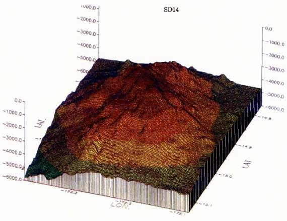
1979 Survey
• The 1979 sampling results conclude that there is little potential for the discovery of manganese nodule
deposits of any significance within the waters of Samoa.
• In the deep water areas, the rate of terrigenous sediment deposition from the Samoan Islands is probably
too great to allow nodule formation.
1986 Survey
• The 1986 survey of the Machias Seamount (Figure 4) concluded that the mineral potential of this guyot is
limited by tectonic dismemberment. The entire trench-facing slope of the seamount has been remobilized
and reworked down-slope and the east-side is characterised by several large slides. This down-slope
reworking of sediment and rock inhibits growth of crusts on rock exposures.
• This survey also suggests that the island of Savaii is probably too young and the surrounding sea-floor
too unstable for thick CRC to have formed. Additionally, the submarine volcanic cones located are too
small to have produced even moderate quantities of hydrothermal mineral deposits.
• Further, sediment samples dredged from seamounts for phosphorite investigation recorded well below
ore grade, and the precious coral sampling work produced negative results.
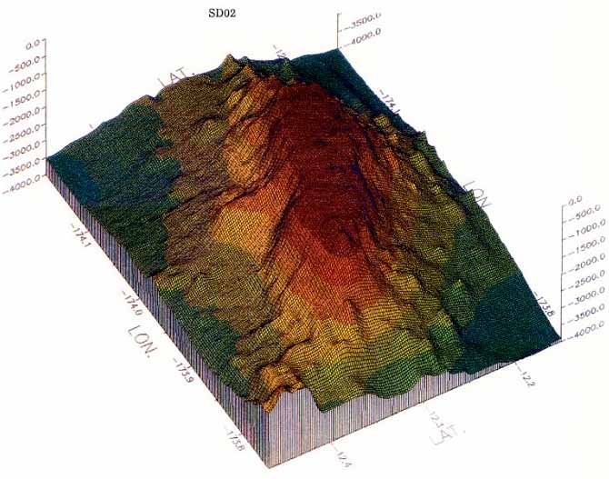
Figure 5. Three dimensional view of the SD02 Seamount.
SPC-EU EDF10 Deep Sea Minerals Project 51990 Cobalt-rich Crusts Survey
The occurrence of CRC in the four seamounts can be generally summarized as follows:
• The average grades of the four seamounts are: Co 0.41%, Ni 0.23%, Cu 0.08%, Mn 17.96%, Fe 20.42%.
• Crust type is prominent, followed by Cobble type and Nodule type and they are prominently distributed
around the upper part and middle part of the slopes.
• The relationship between substrata and grade shows that siltstone has the highest grade, followed by
hyaloclastite and basalt.
• The SD02 seamount (Figure 5) is the best of the four seamounts in terms of coverage (Figure 6a) and
grade.
• Comparing SD02 seamount with other crust bearing seamounts in the region the thickness, grade and
coverage of SD02 seamount are not promising.
• Crusts accumulate over time hence they are expected to develop thinly on relatively young substrata. The
age determined through seamount basalt is 1-4 Ma, which is quite young.
• Crusts are thin (maximum of 13mm) and mono-layered, which is consistent with the young age of the
substrata.
• Similar correlations to those of Manganese Nodules are recognized in grades, i.e. among Mn-Ni-Cu and
between Fe-Co in positive relations respectively.
• A positive correlation between Ni and Co is also observed, which is inconsistent with the property of
Manganese Nodules.
• Co exhibits a tendency to become higher in shallow areas.
• Analyzed grade spotted on the Ni-Co-Cu ternary diagram reveals that Co/Ni is concentrated on elevated
spots.
• The average Co, Ni and Cu grades of surveyed seamounts are low and have a tendency of Fe > Mn.
These properties differ from ordinary CRC.
Figure 6. Photos of seafloor by Free Fall Camera: (a) crust exposure at seamount SD02, (b) brown clay appears throughout the
Manganese Nodules survey area.
1990 Manganese Nodule Survey
• No Manganese Nodules were collected through the 12 attempts.
• No Manganese Nodules were recognized in the 11 photos taken by the deep-sea camera mounted on
the samplers as brown clay appears throughout the survey area (Figure 6b).
• It was therefore inferred that no Manganese Nodules occur in the vicinity of the four stations.
6 SPC-EU EDF10 Deep Sea Minerals Project• The non-recovery of Manganese Nodules during this survey can be attributed to the fact that the sea area
of Samoa is covered with turbidite sediments and slumping sediments and has a series of archipelagic
aprons.
• The existence of the Antarctic bottom current is clarified during this survey, but the potential for Manganese
Nodules occurrence within the EEZ of Samoa is extremely low.
CRC Coverage and Metal Concentration
The survey suggested that crusts are widely distributed on the upper slopes and the marginal parts of
the summits. The crust coverage estimated by FDC observations and other seamount characteristics are
summarised in Table 2.
Crusts that occur on the four seamounts vary in thickness from a patina to 13 mm. The substrates are mainly
sandstone, limestone, basalt and hyaloclastite. The average crust thickness at each seamount, calculated from
the samples collected, is shown in Table 2.
Figure 7 displays the crust thickness and the major metal contents of each seamount.
Figure 7. Thickness and metal contents of cobalt-rich crusts at each surveyed seamount in Samoa.
SPC-EU EDF10 Deep Sea Minerals Project 7Summary of Results
The summary of the Japan-SOPAC survey results in Samoa are tabulated in Table 2 below.
Table 2. Summary results of the Cobalt-rich Crusts survey within the EEZ of Samoa.
Seamount SD01 SD02 SD03 SD04
Type of Seamount Guyot Guyot Peaked Guyot
Seamount size (km x km) 10 x 18 30 x 16 55 x 12.5 2 x 4.5
Seamount height (m) 3,400 3,700 4,000 4,300
Depth to Summit (m) 1,270 330 390 660
Crust type * C with minor B, N & S C with minor B, N & S C with minor B, N & S C with minor B
Crust Coverage (%) 12 25 15 18
Average Thickness (mm) 4.6 4.4 1.2 4.0
Co 0.33 0.48 0.41 0.00
Average
Ni 0.20 0.26 0.23 0.00
Grade (%)
Cu 0.08 0.09 0.07 0.06
Grade variation trend The positive correlation in the Mn-Cu series is distinctive. The relationship of Mn-Ni, Fe-Co and
Ni-Co series is a positive correlation.
Crust Type: C – crust; B – Cobble; P – Pebble; M – Massive; N – Nodule; S – Slab; F sand – Foraminifera sand.
Resource Estimation
Cobalt-rich Crust
A total of 2 million tonnes of inferred crust resources is estimated to have occurred within the EEZ of Samoa.
Cobalt, nickel and copper resources were estimated to be 8,100 tonnes, 4,600 tonnes and 1,700 tonnes
respectively. The details are shown in Table 3 below.
Table 3. Estimation of crust and metal resources within the EEZ of Samoa.
Inferred Resources Metal Resources (tonnes)
Seamounts
(tonnes) Co Ni Cu
SD01 881,000 2,909 1,763 705
SD02 914,000 4,387 2,376 822
SD03 211,000 864 484 147
SD04 14,000 - - 9
Total 2,020,000 8,160 4,623 1,683
Conclusion
Both the Antarctic bottom current and the depth (deeper than the CCD) that are supposed to be necessary
conditions for the growth of Manganese Nodules are recognized within the EEZ of Samoa. However, the
significant occurrence of young turbidite sediments derived from the young Samoan volcanoes is believed to
inhibit Manganese Nodules formation. The results of prospecting to date have failed to discover any promising
nodule deposits and confirmed that the EEZ of Samoa is nodule poor. Given the geologically younger age of
the seamounts in the Samoan chain, the development of crusts is expected to be relatively thin. It takes a long
time for crusts to accumulate on substrates and form thicker layers. The majority of the crusts are thin and
mono-layered, which may be due to the young age of the substrates. The SD02 seamount was the best of
the four seamounts surveyed in Samoa. The crust coverage of this seamount is promising but, considering
thickness and grade, the potential of this seamount is inferior compared to the more promising seamounts of
a number of countries in the region.
8 SPC-EU EDF10 Deep Sea Minerals ProjectYou can also read