GEOINT - Trajectory Magazine
←
→
Page content transcription
If your browser does not render page correctly, please read the page content below
2019 ISSUE 2

THE OFFICIAL MAGAZINE   OF THE UNITED STATES GEOSPATIAL INTELLIGENCE FOUNDATION

Polar
        GEOINT                   U.S. national security interests in the Arctic
                                 heighten as ice melt transitions the region from
                                 a state of isolation to one of increasing access.

                                                         > Blockchain and
                                                           cryptolocation

                                                         > Entrepreneurship and
                                                           innovation in Asheville, N.C.

                                                         > Q&A with Gary Blohm, U.S.
                                                           Army Geospatial Center

                                                                 USG IF.O RG   T R AJ ECTORY   1
YOUR MISSION PARTNER
TOGETHER, WE GO BEYOND®
OPTIMIZED PERFORMANCE.
When you’re truly mission-driven, you don’t stop at data. You partner with your
customer to transform it into intelligence that provides an actionable advantage to our
nation’s warfighters. With rapid advances in machine learning, artificial intelligence, data
visualization and cloud computing, we actively integrate intelligent processing into new
and legacy systems. These innovative applications and enterprise solutions give decision
makers the edge to Go Beyond.®

Find out more at booth 327 during GEOINT 2019.

BALL.COM/GOBEYOND

contents 2 01 9 I S S U E 2
12 POLAR GEOINT
U.S. national security interests
in the Arctic heighten as ice
melt transitions the region from
a state of isolation to one of
increasing access.
By Kristin Quinn
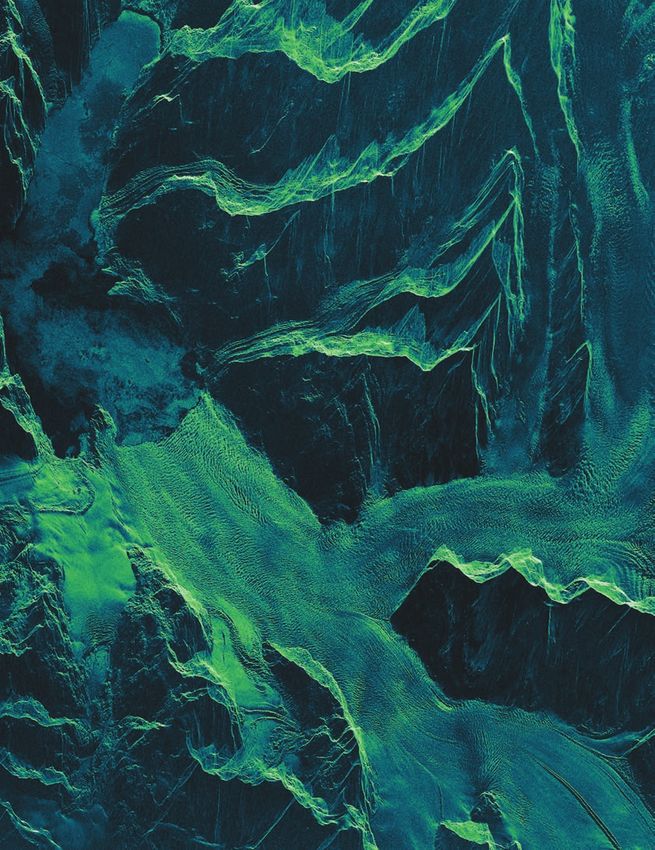
FEATURES 02 | VANTAGE POINT 38 | HORIZONS ON THE COVER:
This ICEYE-X2 radar
Technology powers human Reading List, Peer Intel,
satellite image from
progress, and people have USGIF Events Calendar
22 OCATING THE
L a vital role
Prince William Sound
in Alaska shows ice
BLOCKCHAIN 40 | PERSPECTIVE flowing to the sea.
Image courtesy
The technology that gave 04 | INTSIDER Q&A with Gary Blohm,
of ICEYE
The next era of the small sat U.S. Army Geospatial Center
the world cryptocurrency
revolution; IC ITE’s “Second
is poised to deliver a new Epoch;” USGIF participates in
capability powered by review of the nation’s spatial 40
GEOINT: cryptolocation. data infrastructure
by Matt Alderton
34 | MEMBERSHIP PULSE
Amazon Web Services, Orbital
28 OLLIDING IN
C
Insight, USGIF Individual
Member Angela Hamilton
CLIMATE CITY
Entrepreneurship and
innovation in Asheville, N.C.
TRAJECTORYMAGAZINE.COM
by Melanie D.G. Kaplan
EVENT RECAPS GEOINT 2019
Visit us online for full-length recaps Visit the trajectory website throughout the
of all USGIF events, including Symposium for round-the-clock coverage
workshops, GEOINTeraction of keynote speeches, panel discussions,
TRJ-061
Tuesdays, and more. exhibit highlights, and much more!
vantage point

The Power of Progress                                                                                        USGIF CHAIRMAN OF THE BOARD
                                                                                                             The Honorable Jeffrey K. Harris

Fueled by analytic insight, innovation and disruption          ingredients promise practitioners both        MANAGING EDITOR & PUBLISHER
are occurring with accelerating speed and complexity.          exciting careers and a dynamic future                  Kristin Quinn
Technology enables change, and the fundamental needs,          helping to address real challenges.
                                                                                                                  kristin.quinn@usgif.org
expectations, and desires of individuals and communities           The Foundation includes young
of interest are thereby globally strengthened. Technology      professionals on our Board of Directors.                  EDITOR
powers human progress, and as it becomes increasingly          Their insights and leadership have
                                                                                                                      Brad Causey
ubiquitous, people have a vital role. This revolution is       proven to be invaluable. Isaac Zaworski
indeed human led.                                              is one such example, and I thank him              bcausey@glcdelivers.com
    As USGIF prepares to gather the community at GEOINT        for his dedication and service to the                  ART DIRECTOR
2019, there is excitement in the air. Geospatial data has      Board of Directors. In addition, his
                                                                                                                Gretchen Kirchner Rund
gone mainstream and is opening doors to opportunity and        leadership with the USGIF Young Pro-
innovation. The exponential increase in geographically         fessionals Group (YPG) has resulted in             grund@glcdelivers.com
tagged data offers improved understanding of Earth’s com-      demonstrable dividends in workforce
                                                                                                                   EDUCATION EDITOR
plexity and promotes game-changing advances. Advanced          development. As part of our YPG port-
analytic techniques are tackling previously unsolvable prob-   folio, the USGIF Golden Ticket program               Lindsay Mitchell
lems that are now amenable to new solutions when humans        invites 30 young professionals to join           lindsay.mitchell@usgif.org
and artificial intelligence work together. Harnessing this     us at GEOINT 2019. Each year, all who
power yields improved speed to decision.                       interact with this cohort leave the                      AD SALES

                                                               exchange excited for our shared future.                Don Cooksey
                                                                   Our staff expertise has grown with             don.cooksey@usgif.org
                                                               Karin Fitzgerald and Ronda Schrenk
                                                               bringing important capabilities
                                                               and experience. The USGIF team is
                                                               leveraging their skill sets and has fully
                                                               integrated them into its operational
                                                               cadence. USGIF will soon move our
                                                               Herndon, Va., operation across the
    As an educational foundation, we celebrate these leaps     street to be co-located with the new         Trajectory is the official magazine
and bounds in geospatial pedagogy. In February, USGIF          Trajectory Event Center. This large,          of the United States Geospatial
published version 2.0 of its GEOINT Essential Body of          flexible conference space will allow         Intelligence Foundation (USGIF).
Knowledge. Dr. Camelia Kantor, our VP of Academic Affairs,     us to better serve our community by
was instrumental in driving this substantive advance.          providing facilities to facilitate the           LETTERS AND COMMENTS
The new document leverages the knowledge of our entire         exchange of ideas. USGIF’s Jeff Ley              Email trajectory@usgif.org.
community of practice, which includes industry, govern-        has been leading the development
ment, and academia with 17 USGIF-accredited colleges           of this new space, and we are excited                 SUBSCRIPTIONS
and universities. I was pleased to see Indiana University      for our members to see first-hand the                Sign up for free at
of Pennsylvania’s department of geography and regional         opportunity it will provide to help us            trajectorymagazine.com.
planning achieve USGIF accreditation this year. Personally,    all advance tradecraft, innovation,
this is exciting because my grandfather served as the          and community.                                      USGIF MEMBERSHIP
university’s president.                                            I hope you enjoy this issue of            For information on becoming a
    By defining curricula and offering professional certifi-   trajectory, and I look forward to seeing
                                                                                                           member, email membership@usgif.org.
cations, USGIF strengthens and extends our community           you soon at GEOINT 2019.
and provides value to our Organizational and Individual                                                                  TWITTER
Members. GEOINT is an ever-evolving discipline that
                                                                                                                     @trajectorymag
demands innovative and creative thought leadership to
drive change. We can no longer afford to be tribal and prone
to habit. The research and development among USGIF
Members and the thought leadership demonstrated in our
Working Groups and annual State and Future of GEOINT
Report are powerful catalysts for our tradecraft to redefine
the understanding of humans and their interactions on our
planet. The networking and mentoring across the geospatial     THE HONORABLE JEFFREY K. HARRIS                 PUBLICATION MANAGEMENT

ecosystem remind us of the power of collaboration. These       CHAIRMAN, USGIF BOARD OF DIRECTORS          847-205-3000 | GLCDELIVERS.COM

2   T R AJ EC TO RYM AGAZ I N E .C OM   20 19 I S S U E 2
SPONSORED CONTENT

How GEOINT and Technology Drive Real-World
Problem Solving for Government Agencies
By Lacey Wean, Geospatial Manager, Carahsoft

A    ccurate data is critical in all aspects of GEOINT. Sometimes this data already
     exists and other times it doesn’t exist digitally and has to be collected or
recreated. The data could be a combination of imagery, construction plans, maps or
information. Regardless of the data type, all data is tied to a location.
                                                                                              “ Agencies can take projects a step farther by
    That’s where the benefits of geospatial intelligence technologies kick in.                  bringing the data to life in Virtual Reality or
Technologies such as drones, manned aircraft, satellites and scanners can be paired
with sensors for LiDAR, thermal, hyperspectral, multi-spectral and others to make               physically through 3D printing, providing
it possible for agencies to quickly capture accurate data.
    These technologies are enabling agencies to collect more data than ever before,
                                                                                                additional ways to accurately leverage data.”
dramatically increasing the workload for those people who process and analyze the
data. To keep up with demand, automation is necessary. By forming public
partnerships and implementing artificial intelligence, automation and                    Advances in User-Friendly Tech
augmentation, agencies can filter the incoming data and alert analysts rather than          Geospatial intelligence technologies have come a long way. On one hand,
requiring them to examine everything manually.                                           they’ve made it possible to gather extensive data and then create high-quality
GEOINT Data: Key to Solving Big Problems                                                 outputs, such as maps and 3D models. At the same time, developers have simplified
                                                                                         the user experience, so that generating outputs is more intuitive. Even when users
    By modeling different scenarios, agency teams can project costs for upgrades and
                                                                                         lack a strong background in GIS, they can still produce the high-quality outputs.
repairs to buildings, bridges and dams, for example. Many of these assets are aging,
and there’s no historical data available digitally, so that data has to be collected.    Sourcing is Easier Than Ever
    Once the data is collected, it can be used to create 2D and 3D visualizations that      Access to GEOINT technologies for government agencies interested in
can be put into a map. Algorithms are used to process the data into 3D point clouds      deploying these game-changing technologies is easier than ever, thanks to a Blank
and models and produce outputs. With that knowledge in hand, analysts are able to        Purchasing Agreement recently created by GSA and NGA. The initiative allows
better prioritize among competing demands. Agencies can take projects a step             commercial purchases by government organizations for geospatial earth
farther by bringing the data to life in Virtual Reality or physically through 3D         observation data, products and services, including GIS products, laser scanners,
printing, providing additional ways to enable agencies to accurately leverage data       unmanned      aircraft  systems     and     more.     More     information      at
for real-time decision making.                                                           Carahsoft.com/GEOSPATIAL.

       GEOINT 2019 Carahsoft Partner Pavilion Booth #617                                                                                Visit more of our partners
                                                                                                                                            on the show floor!


           UAS Solutions


                                                                                                                                         Join us at our Carahsoft
                                                                                                                                         2019 GEOINT Reception!
                                                                                                                                                June 4 | 5-8pm
                                                                                                                                               Lonestar Ballroom
                                                                                                                                            Grand Hyatt San Antonio
      © 2019 Carahsoft Technology Corp.                                                          carahsoft.com/GEOINT
C O M M U N IT Y N E W S ,
                                                                                             E V E NTS , A N D E D U C ATI O N

                                                                                                                               USGIF NEWS
                                                                                                                               EDUCATION
      WORKSHOPS                                                                                                                APPLICATIONS

                                                                                                                                                      IMAGE COURTESY OF CAPELLA SPACE
The Next Era of the Small Sat Revolution
                     Since USGIF’s first Small Satellite Workshop in 2015, the       been able to innovate as a result of both government and
Nearly               conversation has evolved significantly from a focus on form     commercial investments. One use case he shared was the

300
people
                     factors to an emphasis on data and analysis.
                         “The last 10 years answered, ‘What is the utility of a
                                                                                     Russian nuclear triad—daily monitoring of air, sea, and land
                                                                                     targets over a vast geography. Planet’s growing portfolio of
                     small sat?’” said Dr. Peter Wegner, chief strategy officer of   3-meter-resolution Dove small sats paired with 1-meter
attended the         Spaceflight Industries, as he moderated a panel discussion      SkySats allow it to tip and cue when an area or target
unclassified         at the most recent workshop. “Now, we’re starting to answer,    requires more detailed observation.
portion of           ‘How do you fuse all of this data together?’”                       The company’s new analytics dashboard offers “efficien-
USGIF’s                  Nearly 300 people attended the unclassified portion         cies to gain across the board,” Barber said. “There’s a lot of
fifth Small          of USGIF’s fifth Small Satellite Workshop Feb. 19 at the        content being created every single day that’s going to have
Satellite            National Geospatial-Intelligence Agency (NGA) in Spring-        to get looked at.”
Workshop.            field, Va.                                                          Increasingly, the human insights enabled by small sats
                         The discussions focused on the latest industry advance-     are becoming the primary focus of the technology.
                     ments in small satellites and launch as well as the future of       “In some examples, the last thing people care about is
                     the technology.                                                 the image,” Barber said. “But they do care about the speed,
                                                                                     the analysis.”
                     ONGOING INDUSTRY INNOVATION                                         Payam Banazadeh, CEO of Capella Space, said his
                     Two of the day’s panel discussions focused on the con-          company is on a mission to “bring SAR back home” on the
                     tinuous small sat advances being made by commercial             commercial side, with the goal to launch a fleet of 36 small
                     providers. Panelist Keith Barber, VP of federal strategic       sats to provide high-resolution, persistent, global coverage.
                     partnerships for Planet, shared how the company has             Capella’s satellites weigh 40 kilograms on the ground, then

4   T R AJ EC TO RYM AGAZ I N E .C OM   20 19 I S S U E 2
Vector Launch’s Vector-R solution will be able to launch payloads of up to                              60 kg for $1.5M
                              transform into larger structures once       received Federal Aviation Administra-
                              on orbit.                                   tion approval for four launch sites.               PROCRASTINATION TOOLS
                                   “36 satellites spread equally within       Potential challenges that lie ahead
                              many [orbital] planes,” Banazadeh said.     for these capabilities include concerns                           Civilisations AR
                              “Three years ago, that was hard—today       about crowded skies, particularly in                              BBC’s augmented reality app
                              it’s only hard because of launch.”          low Earth orbit, as well as interference                          offers a way to interact with
                                   Launch is the next evolution of        with national airspace.                                           historical art and cultural arti-
                              the small sat revolution, according to                                                                        facts from across the world.
                              the panelists.                              DEMOCRATIZING SPACE                                               Users can explore a collection
                                                                          Though venture capital has been flow-                             of more than 30 items includ-
                              ADVANCES IN LAUNCH                          ing into new space companies for the                              ing an Egyptian sarcophagus,
                              TECHNOLOGY                                  past several years, some warned about                             sculptures from Henry Moore,
                              Stella Guillen, VP of sales and market-     the risk of the bubble bursting.                                  and Renaissance mas-
                              ing for Arianespace, said her company           “The loop is not getting closed                               terpieces from Tintoretto,
                              currently has three commercial launch       because these companies aren’t being                              Bellini, and others. A “restore”
                              vehicles and promotes its ability to        purchased,” said Banazadeh. “If we                                feature shows the effect of
                              launch any mass, to any orbit, at any       don’t start seeing a lot of exits … we                            time on history’s greatest
                              time. With 60% of the company’s             won’t see as much VC coming in.”             treasures by estimating their appearance when
                              business being commercial, they are             Some potential solutions to this,        new, and an “X-Ray” feature shows secrets that
                              adapting to accommodate small sats.         according to panelists, would be             might be hidden from plain sight.
                              In August, Arianespace had its first        investments in space-based innova-           Available for iOS and Android
                              purely rideshare mission, and it is         tion by prime contractors or perhaps
                              currently building two new launch           government-led merger and acquisi-
                              vehicles, one of which is specifically      tion policies.                               Inrix Traffic
                              designed with small sats in mind.               Chirag Parikh, director of NGA’s         This innovative navigation app
                                  Vector Launch was founded in            Office of Sciences and Methodologies,        learns users’ driving habits to
                              2016 with the goal of creating small sat    gave a keynote address in which he           create personalized routes,
                              launch vehicles at a new price point,       said, “What’s the point of all of these      recommend departure times,
                              according to Greg Orndorff, VP of           small sats, all of this information, if we   and provide real-time road
                              government services. The company’s          don’t actually get it to the people who      condition alerts. Using a cloud
                              Vector-R solution will be able to launch    need it?”                                    platform, Inrex runs predictive
                              payloads of up to 60 kilograms at a price       Parikh compared the advances in          analytics to estimate times of
                              point of approximately $1.5M, and its       small sat-derived data to the ever-          arrival based on future traffic
                              Vector-H will handle payloads of up to      growing variety, velocity, and volume of     conditions. The app leverages
                              290 kilograms for around $4.5M.             television programming. Television has       OpenStreetMap and crowd-
                                  Vector’s portable, trailer-based        evolved from traditional providers (the      sourced data from its driver
                              infrastructure offers a turnkey solution,   networks), to focused content providers      network to offer the most
                              though will not include mission assur-      (specialized cable channels), to pro-        up-to-date and accurate maps possible.
                              ance. Orndorff said the company has         viders who bundle programming and            inrix.com/mobile-apps
                              already made two Vector-R sales and is      even create their own (Netflix, Hulu,
                              reserving two vehicles for the DARPA        etc.). Similarly, GEOINT has evolved
                              Launch Challenge later this year.           from traditional government providers,                          NASA
                                  VOX Space, a subsidiary of Virgin       to commercial providers and small sats,                         Explore NASA’s mobile app
                              Orbit, is developing the capability to      to the current epoch of analytics-as-a-                         and discover a vast collec-
                              quickly send small sats into low Earth      service providers, Parikh said.                                 tion of more than 17,000
                              orbit using its LauncherOne two-stage           He added the focus needs to be                              images, videos, news stories,
IMAGE COURTESY OF VOX SPACE

                              rocket, which is deployed from a Virgin     not “Can you get this data off of this                          satellite tracking feeds, and
                              747 aircraft.                               satellite in space?” but “Can you get                           more. Users can view NASA
                                  In theory, this method could allow      the data to this particular person?”                            launches and other events in
                              for launch from any airport, according      To do so, he said, will require the                             real-time on NASA TV, watch
                              to Dan Burkett, VOX Space director of       agency to focus on more flexible                                a live stream of the planet
                              strategy and business development,          policy, better standards, and content                           from the High Definition
                              who added the company recently              ingestion and discovery.                                        Earth Viewing experiment on
                                                                                                                                          the International Space Sta-
                                                                                                                                          tion, and investigate featured
                                                                                                                       content to learn more about the solar system
                                                                                                                       and beyond.
                                                                                                                       nasa.gov/connect/apps.html

                                                                                                                                             USG IF.O RG    T R AJ EC TORY      5
GEOINTERACTION
                                                                                         SPOTLIGHT

IC ITE’s “Second Epoch”                                                            Dean Alvarez: A Future in
                                                                                   Computer Science
                                      The Intelligence Community (IC) is
                                      entering the “second epoch” of its Infor-    When attending USGIF’s
                                      mation Technology Enterprise (IC ITE),       GEOINT Symposium, you
                                      IC Chief Information Officer John            never know who you will
                                      Sherman said earlier this month in his       meet and where those
                                      remarks at USGIF’s GEOINTeraction            connections might lead
                                      Tuesday event hosted by OGSystems.           you. Take, for example, the
                                         Sherman has held the post of Assis-       experience Dean Alvarez, a
                                      tant Director of National Intelligence       senior at Strawberry Crest
                                      and IC CIO with the Office of the Director   High School in Dover, Fla.,
                                      of National Intelligence (ODNI) since        had when he attended
                                      September 11, 2017.                          GEOINT 2018 in Tampa.
                                         Sherman said he intends to build              USGIF invited Alvarez, then a junior, and three
                                      upon the many new IC ITE services            other Tampa area high school students to share their
                                      launched—Amazon C2S, the IC GovCloud,        science fair posters during GEOINT 2018’s GEOINT
                                      the IC Apps Mall, and more—as well as        Foreword alongside 22 college students from across
IC CIO John Sherman                   to make necessary changes along the          the country. Alvarez’s research focused on the “Effect
                                      way. He cited one notable change as the      of Various Pooling Methods on Robustness to Adver-
shift away from the IC Desktop Environment (DTE).                                  sarial Examples in Convolutional Neural Networks.”
     “[DTE was] a noble, great idea but as we got into it we recognized a              “It was really cool to talk to people who under-
one-size-fits-all solution wasn’t going to work,” Sherman said. “This had to       stood what I was doing,” Alvarez said. “I learned a
change as we marched into the second epoch.”                                       lot, not just from the experience of talking about my
      Sherman outlined the five pillars he is using as guidelines for the next     poster to professionals in the field, but also from
evolution of IC ITE:                                                               what many of them had to tell me in terms of my
    gility & Adaptability: The IC’s move to the cloud has enabled it to
1. A                                                                               research. It was also interesting to hear from the
   achieve things inconceivable only a few years ago, Sherman said. Moving         speakers [at GEOINT Foreword] about how they are
   forward, the IC will seek to modernize capabilities in data extraction,         applying similar technologies.”
   correlation, and enrichment as well as to embrace new capabilities such             One of the attendees Alvarez had the opportu-
   as quantum computing and high-performance analytics.                            nity to share his project with was Jasen Halmes,
2. Security & Resilience: Sherman’s IC CIO mission statement is “to               CACI’s director of artificial intelligence. As a result
    modernize and protect.” He is working closely with chief information           of their interaction, Alvarez and Halmes exchanged
    security officers across the community to launch a cybersecurity               contact information. Following the Symposium,
    implementation plan that includes: knowing your network; correcting            Alvarez interviewed and was selected for a summer
    inefficiencies; leveraging better technologies such as AI and machine          internship with CACI as a junior research scientist.
    learning to understand the enterprise; and sharing the state of the            Through the internship, he worked with the
    enterprise by passing information about malicious activity against IC          organization’s computer vision research team
    systems through the IC Security Coordination Center in Reston, Va.             and conducted experiments to help advance
3. Interoperability: Following the pivot from DTE, Sherman stood up a             knowledge of deep neutral network applications to
    new group within the IC CIO organization with a focus on embracing             GEOINT challenges.
    reference architectures to ensure interoperability. He described this              “Our team was very impressed with Dean’s
    as moving to a “wheel of seals” where officers can access information          abilities,” Halmes said. “I was struck with both his
    from across intelligence organizations.                                        individual contributions and left with the impres-
4. Usability & Accessibility: This emphasizes ensuring capabilities               sion that we should do more as a community to
    the IC deploys do not leave those in the field behind, which Sherman           foster exposure to our industry technologies. Dean
    said will be more critical than ever as machines are used to                   proved that we could be doing a lot more to encour-
    augment intelligence.                                                          age our future technology leaders.”
5. A ffordability: Though the IC has experienced savings already from                 Alvarez will graduate this spring from his high
    IC ITE, Sherman said there are always new ways to achieve goals more           school’s International Baccalaureate program. He is
    economically and to leverage new technologies. He cited moving to the          still deciding which college he will attend in the fall
    cloud, and therefore shifting from a capability expenditure model to an        and hopes to major in computer science with a focus
    operational expenditure model, as one of the biggest accomplishments           on artificial intelligence. He will be interning at
    under the first epoch of IC ITE—and one he plans to continue.                  CACI once again this summer and intends to build
     All five pillars share a common goal, Sherman said: “Decision advan-          upon last year’s experiences by performing his own
tage for our policymakers and warfighters like we’ve had in the very best          research experiments.
moments of our nation and allied history.”

6   T R AJ EC TO RYM AGAZ I N E .C OM   20 19 I S S U E 2
Digital Mission Modeling
AGI develops commercial software for designing and operating missions within
the aerospace and national security communities. Our software is used
worldwide by public and private sector organizations to model complex
land, sea, air, or space systems and evaluate their performance in real or
simulated time. Systems Tool Kit (STK), now on its eleventh generation,
provides an inclusive modeling environment that supports timely
decision-making in a mission context about complex, inter-related
systems; and can be applied at any stage in their lifecycle: from
planning and design to training and operations.

agi.com/geoint
REPORT CARD                                                                      “Our country
USGIF Participates in Review of the Nation’s Spatial                                     relies on                                  GEOINT
Data Infrastructure                                                                      these                                      Essential
In February, the Coalition of Geospatial Organizations (COGO), of which USGIF            systems                                    Body of
is a member, released the second Report Card in its ongoing review of the U.S.           and data                                   Knowledge
National Spatial Data Infrastructure (NSDI). The document serves as a periodic
assessment of the nation’s geospatial data infrastructure, which, like other forms
                                                                                         every day.
of public works, is essential for the country’s economy, health, safety, and activi-     It helps us
ties of daily life.                                                                      in so many
    The Report Card leveraged the input of subject matter experts with knowl-            ways. It
edge in each of the eight national framework data themes: addresses, cadastres,
elevation, geodetic controls, governmental units, hydrography, orthoimagery,             makes                         TRADECRAFT
and transportation. USGIF Vice President of Academic Affairs Dr. Camelia Kantor          us more                The GEOINT
serves as the Foundation’s COGO delegate and contributed to the report as a              efficient              Essential Body of
reviewer in the area of transportation.
                                                                                         and                    Knowledge 2.0
    Each team assessed the developments and advances within their respective
themes since the original Report Card was published in 2015 and engaged with             prosperous.”          USGIF published version 2.0 of
the Federal Geographic Data Committee as they determined new individual                 — SHELBY               its GEOINT Essential Body of
scores. The NSDI as a whole received a grade of B-, reflecting some improvements        JOHNSON, 2019          Knowledge (EBK) in February.
                                                                                        CHAIR, COGO
from its 2015 grade of a C.                                                                                    The GEOINT EBK is the founda-
    “Our country relies on these systems and data every day,” said Shelby Johnson,                             tion for USGIF’s efforts to create
the 2019 COGO Chair. “It helps us in so many ways. It makes us more efficient                                  a pipeline for the global GEOINT
and prosperous. The challenge is maintaining the themes where we are doing                                     workforce via its K-12, Collegiate
well, then finding the will and the means to improve on the rest. Our hope is this                             Accreditation, and Certified
will assist government agencies in collaboratively completing and maintaining                                  GEOINT Professional (CGP™)
the NSDI. We still have a long way to go.”                                                                     programs.
    The latest assessment is intended to encourage continued and critical                                          The EBK is developed by
improvements to U.S. national geospatial infrastructure.                                                       conducting a cross-industry job
                                                                                                               analysis to identify the knowl-
                                                                                                               edge, skills, and abilities critical
                                                                                                               to the GEOINT workforce, and
                                                                                                               outlines standards for the broad
                                                                                                               practice of GEOINT.
                                                                                                                   “Version 2.0 of the EBK is
                                                                                                               significantly more compre-
                                                                                                               hensive and helps guide the
                                                                                                               pathway into GEOINT learning
                                                                                                               starting from high school,
                                                                                                               moving into college, and into
                                                                                                               the professional workforce,”
                                                                                                               said USGIF Vice President of
                                                                                                               Academic Affairs Dr. Came-
                                                                                                               lia Kantor. “With this newly
                                                                                                               revamped document, the intent
                                                                                                               is to bridge the gaps between
                                                                                                               high school prerequisites,
                                                                                                               collegiate credentials, and
                                                                                                               professional certifications in a
      ST. LOUIS                                                                                                continuum of building blocks.”
                                                                                                                                As the GEOINT
SLU and NGA Host Geospatial 101 Series
                                                                                                                            profession continues
Saint Louis University (SLU) and the National Geospatial-Intelligence                           USGIF’s Dr. Kantor          to evolve, so does
                                                                                         recently spoke about the
Agency (NGA) hosted a four-part presentation series that explores how                                                       the EBK, reflecting
                                                                                         revised EBK in a webinar
geospatial data is used to visualize patterns of poverty, crime, and unem-                                                  meaningful changes
                                                                                         co-hosted by Directions
ployment in the St. Louis region. The “Geospatial 101” series was a result of            Magazine and the GeoTech           to the tradecraft
a Collaborative Research and Development Agreement NGA and SLU signed                    Center. Check it out at            and incorporating
to establish a joint geospatial research and training initiative. Presentations          directionsmag.com/                 new technology and
were held in February and March at SLU’s Learning Resources Center and                   webinar/8109.                      methodologies.
were free and open to the public.

8   T R AJ EC TO RYM AGAZ I N E .C OM   20 19 I S S U E 2
K-12
A Variety of EdGEOcation Events
Following the winter break, USGIF was back in classrooms
sharing GEOINT knowledge. In January, USGIF gave geometry
students from Seneca Ridge Middle School in Sterling, Va., a
lesson on similar triangles and rates and proportions using GIS
to calculate island erosion and distances across rivers.
In March, USGIF’s Portable Planet map visited Creighton’s
Corner and Moorefield Station Elementary Schools in Ashburn,
Va. More than 450 students completed activities on the map.
USGIF also visited John Champe High School in Aldie, Va., to
help with a research project focused on identifying pollutants
in Loudoun County. The Foundation and Esri teamed up with
juniors and seniors in AP environmental science and computer
science classes to assist in visualizing their data using ArcGIS.
Also in March, USGIF and members of its Young Profes-
sionals Group (YPG) participated in a variety of STEM events.
USGIF exhibited at the first annual Dyslexic Edge: Pathways to
STEM Excellence Conference and Festival at George Mason
University, an event hosted by Sliding Doors STEM & Dyslexia
Learning Center. The group also attended WashingtonExec’s
K-12 STEM Symposium in partnership with Riverside Research.
At both events, children built their own satellite models and
learned how to analyze satellite images.
USGIF also participated in the Fairfax and Loudoun County
Regional Science Fairs, awarding students with $500 each for Madison High School student Arnav Wadehra won $500 from USGIF for his
the best project in geospatial achievement. geospatial project in the Fairfax County Science Fair.YPG members learned about contract types and vehicles during an Acquisitions 101 presentation hosted by Planet.
YPG
Young Professionals in Action
In February, YPG hosted the second edition in its Acquisitions 101 series at Planet’s office in
Washington, D.C. Keith Barber from Planet and Nick Buck of Buck Consulting Group spoke about To learn more about
contract types and services as well as licensing versus services. USGIF’s YPG, visit usgif.org/
community/YPG.
YPG also participated and exhibited at NGA’s Interagency Mentoring and Collaboration
Workshop at both NGA Campus East and West March 23. This event is an opportunity for young
professionals to attend sessions on career development and connect with peers and potential mentors.
Meanwhile, USGIF’s YPG is expanding its outreach in St. Louis, Mo. Members of YPG based in the St. Louis area have hosted informal
networking events each month, gaining traction for a potential St. Louis YPG chapter.
“The students, GEOINT CERTIFICATES
faculty, and Indiana University of Pennsylvania Earns
administration USGIF Accreditation
at IUP are USGIF added Indiana University of Pennsylvania (IUP) to its growing Colle-
extremely giate Accreditation Program, bringing the total of USGIF-accredited colleges
and universities to 17.
excited about IUP offers both undergraduate and graduate GEOINT Certificates as part of the university’s depart-
USGIF’s ment of geography and regional planning. The department has a long history of geography education
with strong programs in cartography and geographic information science.
accreditation.” “The students, faculty, and administration at IUP are extremely excited about USGIF’s accredita-
—JOHN BENHART, JR., INDIANA tion,” said John Benhart, Jr., Chair of IUP’s Department of Geography & Regional Planning and Director
UNIVERSITY OF PENNSYLVANIA of Geospatial Intelligence Certificate Programs. “USGIF accreditation is an acknowledgment of the
quality, rigor, and applicability of the department’s geospatial curriculum, and will provide students
vastly increased opportunities for internships, professional development, and employment in the
fast-growing geospatial intelligence sector.”
10 T R AJ EC TO RYM AGAZ I N E .C OM 20 19 I S S U E 2Establishing the Autonomous
Connected Battlespace
Hexagon solutions enable the visualization, analysis, and management of sea, air, land, and
space-based resources in a complete cyber-secure framework. Our innovative integration of
these elements into mission-focused autonomous connected ecosystem (ACE) solutions are
vital to all branches of the military as well as intelligence and combat support agencies.
Stop by our booth at GEOINT to test drive our solutions designed to improve
mission effectiveness, including tactical laser mapping, AI at the edge,
real-time battlefield visualization, and advanced geospatial analytics.
| Visit us at GEOINT booth 939 or hexagonusfederal.com
©2019 Hexagon US Federal. Hexagon US Federal is part of Hexagon. All rights reserved.po l U.S. national security interests
in the Arctic heighten as
ice melt transitions the region
from a state of isolation to
one of increasing access.
BY KRISTIN QUINN
12 T R AJ EC TO RYM AGAZ I N E .C OM 20 19 I S S U E 2a r
ARCTIC SPECIAL
FEATURE
> T
HE FUTURE
OF DIGITAL
ELEVATION
MODELS
> GUARDING THE
ARCTIC COASTS
> EYES ON THE ICE
GEOINT
UNTIL RECENTLY, the world knew more
about the terrain of the moon and Mars than it
did about Earth’s polar regions. But today,
thanks to groundbreaking collaboration among
geospatial experts across United States government,
industry, and academia, the Arctic is now one of the
best-mapped places in the world. >>
USG IF.O RG T R AJ ECTORY 13THE FUTURE OF DIGITAL ELEVATION MODELS
According to nearly all scientific accounts, the Arctic is “As we monitor how changes in
also one of the fastest naturally changing places on Earth
and is experiencing global warming at extreme rates. In the Arctic influence geopolitical
May 2013, the White House published the country’s first landscapes, we will balance our
National Strategy for the Arctic Region, followed in Novem-
ber of that year by the Department of Defense’s (DoD) Arctic investments against the
release of its Arctic Strategy. Both documents acknowledge Department’s responsibilities
heightened U.S. national security interests in the Arctic as
ice melt causes it to transition from a state of isolation to and objectives around the world,
one of increasing access. while collaborating domestically
“The [DoD strategy] recognizes the role that the Arctic
region will play in shaping the global security environment
and internationally to help
in the 21st century,” then Secretary of Defense Chuck develop effective solutions.”
Hagel wrote in the foreword. “As we monitor how changes —FORMER SECRETARY OF DEFENSE CHUCK HAGEL
in the Arctic influence geopolitical landscapes, we will
balance our Arctic investments against the Department’s
responsibilities and objectives around the world, while
collaborating domestically and internationally to help Foundation (NSF) and known as Arctic DEM, exceeded
develop effective solutions.” expectations and brought together a powerful coalition to
The Arctic gained even more national attention in 2015, produce an unprecedented geospatial product that no mem-
when the U.S. took the helm of the Arctic Council, an inter- ber could have achieved alone.
governmental forum among eight stakeholder nations that “[This project] is extremely beneficial to our community
rotate chairmanship every two years. In a related Executive that wants to do change studies and attribution,” said Dr.
Scientists are
using Arctic
Order titled “Enhancing Coordination of National Efforts Kelly Faulkner, director of NSF’s Office of Polar Programs, of
DEM data of the in the Arctic,” the White House listed U.S. interests in the the decision to fund Arctic DEM. “We could see the scientific
Lena Delta at the region as: “national defense; sovereign rights and respon- benefit in addition to the operational benefit.”
end of a remote
river in Siberia sibilities; maritime safety; energy and economic benefits;
to study river environmental stewardship; promotion of science and SPARKING INNOVATION
systems that research; and preservation of the rights, freedoms, and uses The common standard for global DEMs are those generated
are otherwise
inaccessible. of the sea as reflected in international law.” from NASA’s Space Radar Topography Mission (SRTM) in
In September 2000. The 30-meter dataset was made public in 2015, but
2015, in coincidence no information was collected north or south of 60 degrees,
with President Obama’s i.e., Earth’s poles.
tour of the Arctic, the “Prior to 2010 and our partnership with the National
National Geospatial- Science Foundation, NGA did not have a lot of unclassified
Intelligence Agency satellite imagery requirements in the polar regions, but in
(NGA) released its that same year, through our commercial partnership with
unclassified Arctic DigitalGlobe, NGA’s capacity to collect large amounts of
website. That same unclassified satellite data over these areas of the Earth had
day, the President increased dramatically,” Bates said.
announced the NGA began collecting stereo imagery from polar orbits in
agency’s ambitious 2010 through its commercial imagery program, according to
public-private part- Bates. In 2015, in accordance with the President’s Executive
nership, formed to Order and with plans for Arctic DEM in the early stages,
develop the first pub- the agency redoubled its efforts, aiming to collect as many
lic, high-resolution, stereo pairs of Arctic and Antarctic imagery as possible.
satellite-based digital “Our colleagues [at Ohio State] came up with an algo-
elevation model rithm that could take stereo images and create the z-axis
(DEM) of Alaska in mapping and get DEMs produced out of electro-optical
2016, and of the entire satellite images at the unclassified level,” Bates said.
Arctic by 2017. But at the 2015 release of NGA’s public Arctic website,
“The public this algorithm was still immature.
website sat there for a
year with all of these
great products, but
POLAR DEMS BY THE NUMBERS
the DEM piece was The Arctic and Antarctica is The Arctic DEM
missing,” said Brian Antarctica approximately and REMA projects
Bates, a data scientist comprise 50% larger produced 35
IMAGE COURTESY OF NGA
with NGA’s Office of approximately than the million square
Strategic Operations. 10% of Earth’s continental kilometers of
The resulting land mass U.S. elevation data in
project, funded by three years.
the National Science
14 T R AJ EC TO RYM AGAZ I N E .C OM 20 19 I S S U E 2“We went through months of working closely with the
scientists, making corrections, and holding test runs before
we thought we could produce a product we would all be
proud to put our names on,” Bates said.
Once the algorithm was ready for prime time, the team
needed an unclassified, high-performance computer
in order to apply it at scale. Paul Morin, director of the
Polar Geospatial Center at the University of Minnesota, A shaded
which served as the lead organization on the Arctic DEM relief version
of the
project, contacted the National Center for Supercomputing Reference
Applications at the University of Illinois at Urbana- Elevation
Model of
Champaign. The center’s Blue Waters supercomputer is Antarctica
one of the world’s fastest and largest computers, according (REMA).
to Bill Kramer, senior associate director of the Blue Waters
Project Office.
The Blue Waters office only takes on partners with
substantial missions that would be nearly impossible to
achieve without the use of the supercomputer.
“By concentrating the computing and analysis features
of Blue Waters plus applying our special support staff we
make these projects productive and decrease their time
THE REFERENCE
to solution,” Kramer said. “We’re not wide breadth with ELEVATION MODEL
thousands of people using Blue Waters. It’s the people OF ANTARCTICA
who have a frontier scientific challenging in front of Fueled by the success of Arctic DEM, the same team—this time led by
them, and in this case the DEM work far exceeded those The Ohio State University—pressed on to produce the Reference Ele-
expectations.” vation Model of Antarctica (REMA) in September 2018. REMA boasts
Blue Waters’ vast computing, data storage, data move- a resolution of 2 to 8 meters, compared to 1,000 meters, which was
ment, and wide area networking capabilities enabled the typical for previous maps of the continent.
Arctic DEM team to deliver its first data release ahead of According to a study published in February by the National Acad-
schedule, and to eventually go on to produce the Reference emy of Sciences, Antarctica is losing six times as much ice as it was
Elevation Model of Antarctica (REMA), a similar project for 40 years ago. And Antarctica has significantly more ice than the
IMAGE COURTESY OF POLAR GEOSPATIAL CENTER
Earth’s southern pole. Arctic, at least on land, but is much flatter.
Once the DEMs were generated using Blue Waters, Since elevation is what requires such extensive computing power
the next step was to make the massive data trove publicly to process, REMA was able to be produced in a matter of a few
available. Esri’s ArcGIS Image Server is designed to manage months instead of over a couple of years.
extensive volumes of imagery and to process the data on “At this resolution, you can see almost everything,” said Ian Howat,
the fly, according to Peter Becker, the company’s senior director of the Byrd Polar and Climate Research Center at The Ohio
product manager for imagery. State University, in a university news story about the project. “We can
“On the fly means the data is processed as you access actually see variations in the snow in some places. We will be able to
it instead of pre-processing,” Becker said, adding that this measure changes in the surface of the continent over time.”
means users can actually take measurements of the data
and study change rather than simply panning and zooming
across cached web tiles.
“Users can say they want to see the difference between (often ice) or conduct time series plotting with results that
two different dates,” Becker continued. “The server will find are accurate within a couple of meters.
those dates, subtract between one and the other, and send As a result, environmentalists, policymakers, and
that difference back to the user.” national security leaders alike are able to observe quickly
Today, following its seventh data release in September and in detail information related to changes in navigation
2018 at 2-meter resolution, visitors to the Arctic DEM web- routes, deforestation, glacial retreat, coastal erosion, the
site can draw a line to designate a desired area of study and construction of new roads and buildings, and much more.
view the DEMs covering that area—in some cases as many as The information has been a treasure trove for scientific
40 to 60. Users can calculate the volumetric loss of elevation research and is also highly useful for planning operations
in the north without the need for expensive, risky, or near-
impossible reconnaissance flights.
“This is a component of Arctic situational awareness,”
The creation of Arctic DEM Arctic DEM and Morin said. “We’re talking about denied airspace, in a form
and REMA required more than REMA include that it’s not denied by an air force or government, but sim-
1.5 billion core hours of 400 terabytes ply because of geography.”
compute time—the equivalent of terrain data As the U.S., other Arctic nations, and interested observ-
of running the fastest and nearly ers work to create a global framework for the modernization
desktop computer money can 200,000 and expansion of commercial and government activities
buy for 50,000 years. individual DEMs. in the Arctic, the ability to quickly and accurately monitor
change will become increasingly useful.
USG IF.O RG T R AJ ECTORY 15THE FUTURE OF DIGITAL ELEVATION MODELS
A POWERFUL PRODUCTION CHAIN
The National Science Foun- The University of elevation models. Ohio State was the
dation (NSF) provides Minnesota’s Polar lead organization for the REMA project.
funding for high-risk, Geospatial Center
high-reward science, includ- (PGC) requested and The University
ing the Arctic Digital Elevation stored imagery from NGA of Illinois at
Model (DEM) and the Reference Eleva- and served as the lead Urbana-
tion Model of Antarctica (REMA) organization for the Arctic DEM project. Champaign’s Blue Waters supercom-
as well as the Ohio State algorithms puter is one of the largest in the world
and University of Illinois supercomputer The Ohio State and provided the computing power
that made both models possible. University Byrd necessary to efficiently convert vast
Polar and Climate quantities of stereo electro-optical
The National Geospatial- Research images into 3D DEMs.
Intelligence Agency (NGA) Center developed the
provided commercial imagery for open-source Surface Extraction from Esri provides the
Arctic DEM and REMA through its TIN-based Searchspace Minimization image servers to
contract with Maxar’s DigitalGlobe in (SETSM) algorithm that makes it host and process
addition to subject matter expertise in possible to convert commercial, the DEMs for both
DEM production. electro-optical imagery to digital projects on the fly.
“We’re talking about elevation as a standard derived Data Infrastructure group, born under the Atlantic Coun-
product from remote sensing at this point—just something cil and led by USGS, takes a more GIS-based approach to
that’s produced as a matter of course,” Morin said. understanding the region and unifies the mapping agencies
“Before, people were doing change detection, but from of all Arctic nations for data sharing.
pictures. That’s very different than change detection “USGS has very strong standards for mapping and there
from surfaces.” was some skepticism initially,” Faulkner said in reference to
Faulkner emphasized NSF’s long history with mapping Artic DEM. “But as they began to see the products coming
agencies such as the U.S. Geological Survey (USGS) that have out they evolved their thinking. I think we sparked the inno-
a vested interested in mapping the Arctic. The Arctic Spatial vation and others are starting to pick up on it.”A MULTI-DISCIPLINARY FEAT with the agency. In an effort to perform automated quality
The interdisciplinary, highly collaborative Arctic DEM project assurance work on Arctic DEM data and expand upon those
created an entirely new way of developing accurate surface efforts, NGA awarded a five-year, $15 million contract to
maps—one that likely couldn’t be achieved by any other GeoNorth Information Systems (GNIS) in August 2018.
country, said Kramer, pointing to all of the physical and intel- Anchorage-based GNIS, in partnership with Lockheed
lectual resources that came together to make this possible. Martin and the University of Alaska Fairbanks, will provide
Faulkner hailed the collaboration across government, NGA with access to scalable geospatial data processing tools
industry, and academia as “extraordinary” and added, “I to produce specified foundation products and services.
can’t tell you how beautiful this is if you’re a scientist.” “NGA has extensive capabilities and very refined and
Morin noted the significance of taking a scientific detailed data products,” said Jonathan Heinsius, general
approach to the daunting task. manager and director of geospatial programs at GNIS. “They
“What we did was revolutionary—and when we did it there are very interested in having data products and services that
wasn’t a spec written,” Morin said. “We didn’t know what the are readily shareable and open for a place like the Arctic,
accuracy, repeat, or precision would be. That was all written which is very much about international collaboration.”
after it was produced. It wasn’t the government way, but the Part of this effort will include scouring Arctic DEM to auto-
scientific way. In science, we write the paper after the dataset is matically correct for any data artifacts, according to Crittenden.
produced. In government, it is the other way around—the gov- “There’s a lot of land to go through,” Crittenden said.
ernment writes the [RFP] and then vendors have to meet that.” “For us to do that in our standard production would take
Bates said by partnering with civil federal agencies and a long time.”
universities, NGA was able to achieve much more than its The innovative Arctic DEM project has shown the value
individual budget and capabilities would have allowed. and potential of time-dependent terrain, and many geospa-
Now, the polar science and geospatial communities are tial experts are now interested in applying the method for
rallying around how to analyze the DEM. other areas of the globe.
“Even here where we built this stuff we have a hard time Crittenden added he would like to see a process similar
dealing with how to analyze this much,” Morin said. “What to Arctic DEM used for coastal areas around the world.
do you do with 400 terabytes of data? And that number is “In the event of a disaster or emergency we would have
never going to get any smaller. … We’ve already burned piles unclassified data we could share immediately to help first
of computing time producing this, now we need more time responders,” he said.
to figure out what’s in it.” Morin concluded that Arctic DEM has ushered in a
NGA is already experiencing a steady stream of requests “golden age of topography,” and said, “Between this and
for unclassified 2-meter data of Alaska, Greenland, and LiDAR we can know the structure of the Earth’s surface like
Russia, according to Chuck Crittenden, an applied scientist we’ve never known before and we can watch it change.”GUARDING THE ARCTIC COASTS
AS THE PHYSICAL AND GEOPOLITICAL
IMAGE COURTESY OF DEPARTMENT
landscape in the Arctic continues to evolve, the U.S.
Coast Guard is going to be present in the region more
often and in increasing numbers, according to two Coast
OF HOMELAND SECURITY
Guard analysts working at the National Geospatial-
Intelligence Agency: Jason Tucker, a civilian, and IS1 Rob
Wright, who is active duty.
“GEOINT is of utmost importance to the Arctic,”
Wright said.
Tucker and Wright both said they are experiencing sig- A digital rendering of a cubesat that will be part of the Coast Guard’s
Polar Scout project.
nificantly more requests for Arctic-related work compared
with four or five years ago. They provide the Coast Guard’s next 20 to 50 years, and take that environment into account
Intelligence Coordination Center with visual representa- to realize there is a need for a new Polar Security Cutter,”
tions of changing ice coverage, increasing vessel activity, Wright said.
regional infrastructure, and predictions such as Looking ahead, Wright and Tucker predict the demand
the potential for mineral consumption or antici- for Arctic GEOINT products will continue to grow as new
“The [cubesat pated ice melt. cutter capabilities enable the Coast Guard to have a stronger
sensors] will be In addition to illustrating polar ice transforma- presence in the far north.
tion, the analysts are also able to reveal navigable
able to detect waters and how vessels transit these waters at CUBESATS FOR SEARCH & RESCUE
the [EPIRB] times they haven’t been able to in the past, accord- The Coast Guard Research, Development, Test, and Eval-
stress beacon, ing to Tucker.
Doing so helps the Coast Guard gauge its
uation (RDT&E) Program is testing two cubesats with the
Department of Homeland Security (DHS) Science & Technol-
geo-locate it, preparedness for more frequent search-and-rescue ogy Directorate to evaluate the use of space-based sensors in
and send that missions in the Arctic.
“The Crystal Serenity cruise ship went through
support of Arctic search-and-rescue missions.
In December two cubesats, dubbed Yukon and Kodiak,
information in 2016 with thousands of people on it and there’s were launched into low-Earth polar orbit on a rideshare
to the MC3 really not any search-and-rescue infrastructure
up there,” Wright said. “What if the ship had hit a
mission from Vandenberg Air Force Base in California. The
Polar Scout project will be used to inform satellite tech-
ground rock? We’re showing there’s a lot more people in nology recommendations for many potential applications
station.” the Arctic, a lot more vessel activity.”
Recently, the duo’s analysis helped inform Con-
within the Coast Guard and across DHS.
In addition to the cubesats, the program includes two
—HOLLY WENDLIN, gress’ decision to fund six Polar Security Cutters Mobile CubeSat Command and Control (MC3) ground
U.S. COAST GUARD
RDT&E PROGRAM to replace the Coast Guard’s two legacy ships. At stations, one at the Coast Guard Academy in New London,
press time in April, the service was said to be close Conn., and one at University of Alaska Fairbanks. The team
to awarding a contract for the first icebreaker. will use a civilian icebreaker to take out Emergency Position
Wright and Tucker created a graphic that visualized Arc- Indicating Radio Beacons (EPIRBs) for testing this summer.
tic maritime domain awareness, including SAR agreements “The [cubesat sensors] will be able to detect the [EPIRB]
and available infrastructure such as airfields, airports, and stress beacon, geo-locate it, and send that information to the
port areas. MC3 ground station,” said Holly Wendlin, C4ISR Domain
“[Decision-makers] could see all at once, this is what the Lead for RDT&E.
operating environment looks like currently, this is what we Wendlin said the Polar Scout team aims to conclude its
think the operating environment is going to look like in the final report by the end of the year.
PHOTO BY NYXOLYNO CANGEMI/U.S. COAST GUARD
The U.S. Coast
Guard Cutter Healy
carries around 100
crew members and
30 scientists to
deploy sensors and
semi-autonomous
submarines
to study how
environmental
factors affect the
water below the
ice surface for the
Office of Naval
Research.
18 T R AJ EC TO RYM AGAZ I N E .C OM 20 19 I S S U E 2EYES ON THE ICE
ICESat-2 will use
six laser beams to
measure the height
of ice, as illustrated
in this not-to-scale
artist’s rendering.
IMAGE COURTESY OF NASA
THE LATEST GENERATION of remote sensing This will lead to new insights, considering planes aren’t
satellite technology offers more ways than ever for able to fly below cloud cover, and clouds are more frequent
humans to learn about the Earth’s changing poles. during warmer seasons. The advanced ICESat-2 technique
also appears to be able to see through water, mapping
NASA’S NEWEST ICESAT heights in streams or reservoirs and in some cases seeing
In September 2018, NASA launched its ICESat-2 photon- depths down to 30 meters.
counting LiDAR satellite to characterize Earth’s polar ice “A lot of people will be interested in this data,” Wagner
sheets and sea ice. said, adding that groups such as NOAA and the Army Corps
ICESat-2’s laser pulses 10,000 times per second, sending of Engineers have already taken notice.
light to the ground, collecting the returning photon in its The first ICESat-2 data release is expected to take place in
telescope, and recording the photon travel time. Because the the first half of 2019.
speed of light is constant, travel time can be converted to
distance traveled. But doing so requires precise knowledge FINLAND’S ICEYE STARTUP
of the satellite’s location using GPS and star trackers. One of the first use cases Finland-based ICEYE explored
According to Tom Wagner, NASA’s ICESat-2 program for its commercial synthetic aperture radar (SAR) satellite
scientist, the original ICESat, launched in 2003 and constellation was monitoring Arctic conditions in real time,
de-orbited in 2010, had 170 meters between footprints according to company chief scientific officer and co-founder
(spots illuminated), but ICESat-2 has only 70 centimeters in Pekka Laurila.
between. Wagner used a football field analogy to quantify
the advance. This ICEYE-X2 radar
satellite image
“The original ICESat put one footprint in each end from Prince William
zone, and ICESat-2 gives us a footprint on every yard line,” Sound in Alaska
shows ice flowing
he said. to the sea.
To “bridge the gap” between the two ICESats, NASA’s
IceBridge airborne survey mission mapped each polar
region once a year, flying over the Arctic from March to May
and over Antarctica from October to November. The new
satellite mission will decrease the need for costly, risky, and
technologically limited flights, according to Wagner. And
so far, ICESat-2 is exceeding expectations.
“We’re getting a far greater signal from the ground
than expected, and with the photon-counting mission,
we’re going to be able to see through the clouds in most
areas,” Wagner said. “ICESat-2, we’re hoping, is going to
give us a new look at what goes on, especially during the
warmest periods.”
IMAGE COURTESY OF ICEYE
USG IF.O RG T RAJ ECTORY 19You can also read