2021 EQUIPMENTS - OHSAS 1801 - Incostas Nouel
←
→
Page content transcription
If your browser does not render page correctly, please read the page content below
2021

EQUIPMENTS

                ISO             ISO            OHSAS
                9001           14001            1801
             INTERNATIONAL   INTERNATIONAL    INTERNATIONAL
               CERTIFICATE     CERTIFICATE      CERTIFICATE
                 QUALITY     ENVIRONMENTAL    OCCUPATIONAL
                GARANTEE      MANAGEMENT     HEALTH & SAFETY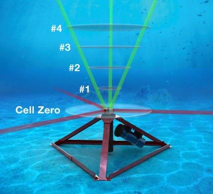
MV Neptune

             The MV Neptune has been specifically
             designed       as      a  multi‐purpose
             oceanography,              geophysical,
             geotechnical,             geochemical,
             environmental and ROV DP support
             vessel.
             MV Neptune was originally designed for
             cold weather localities and is certified
             with Class 1A Ice Rating.

                                                   2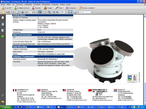
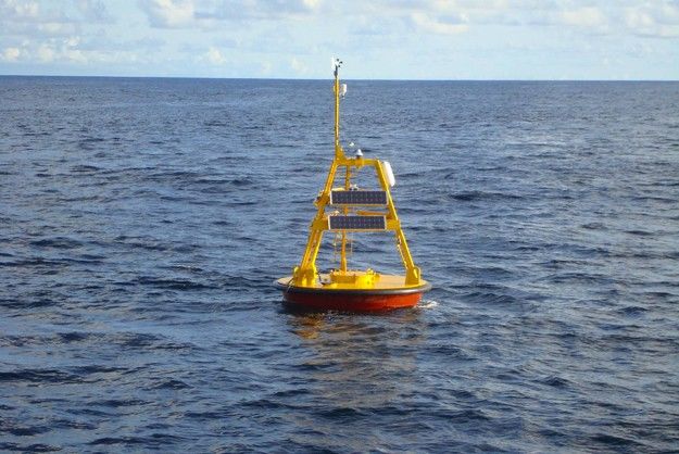
Directional wave recording buoy

AXYS Technologies 3-METRE y WatchKeeper

Oceanographic Buoys for measurements of:
· Directional Wave
· Wind direction and velocity
· Water Temperature
· Environmental temperature and relative
humidity
· Barometric Pressure
. Satellite data telemetry

                                           WATCHKEEPER
      AXYS Technologies 3-METRE

                                                         3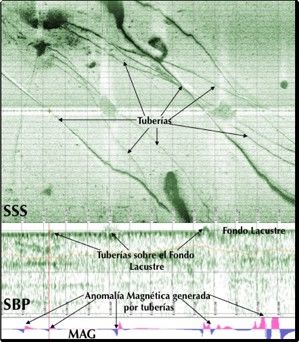
2021                              Equipments
                                       Oceanographic & Hidrographic

            •   Digital Current Meters
            •   Acoustic Doppler Current Profilers (ADCP)

            •   Tide Gauge Registers
            •   24/33/200 kHz Echosounders
            •   2/7KHz Sub Bottom Profiler

            •   6, 12 and 30 channels Differential GPS/Glonass
            •   Salinómeters, thermometers and CTD sounders
            •   Water and Sediments Samplers
            •   Digital Anemometers

            •   GNSS
            •   HYPACK System
            •   Wave Spectral Analysis
            •   Tide Armonic Analysis

            •   Currents as a function of Tide Mathematics
            •   AutoCAD Field Data Processing

1.

                                                                      4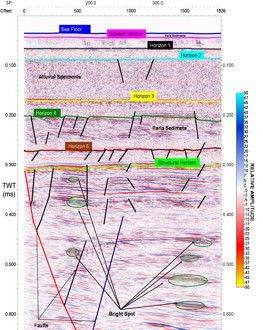
Chirp Registry

                 Sonda ctd mini de Valeport

                                              5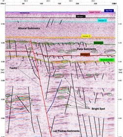
Nortek Aquadopp Current Profiler

The Aquadopp® profiler measures the current profile in water using
acoustic Doppler technology. It is designed for a wide range of
applications and can be deployed on the bottom, on a mooring rig,
buoy or on any other fixed structure.
It is a complete system and includes all parts required for a self
contained deployment with data stored to an internal data logger. The
Aquadopp profiler is a small and lightweight profiler for use over
profiling range from of 1 to 100m.

                                                                        6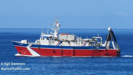
Nortek AWAC AST Current Profiler

The AWAC is designed as a coastal monitoring system.
It is small, rugged, and suitable for multi-year
operation in tough environments. The mechanical
design is all plastic and titanium to avoid corrosion.
The AWAC is available in three transmit frequencies
(1000/600/400kHz) which allow for different
deployment depths.
The sensor is usually mounted in a frame on the
bottom, where it is protected from complications at
the surface such as harsh weather, vandalism, and ship
traffic. While safely located at the bottom, it is
operated in online or in stand-alone mode. In stand-
alone mode, the raw data are stored to the internal
data logger and power comes from an external
battery pack. A variety of options are available with maximum deployment lengths of 12 months with
hourly wave data when using lithium batteries. Online systems have a variety of possible communication
configurations. The most common are long, offshore cables (max. 5 km) or acoustic modems. Online
systems can be delivered with backup batteries, protected cables, shore side interface units, and online
software.

                                   The AWACs extraordinary wave performance has largely to do
                                   with the Acoustic Surface Tracking (AST). The AST is based on
                                   echo ranging to the surface with the vertically oriented
                                   transducer. The beauty of this method of measuring waves is that
                                   it circumvents the depth limitations imposed by bottom
                                   mounted pressure and velocity measurements. Long waves
                                   (swell) and storm waves are rarely difficult to measure, however
                                   waves generated by local winds are challenging without AST.
                                   Moreover, the AST also gives you the ability to derive wave
                                   parameters based on times series analyses. This means that the
AWAC can directly measure wave parameters such as Hmax, H1/10, Tmean, etc. which other bottom
mounted systems simply cannot.

                                                                                                      7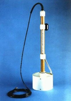
Nortek Continental Current Profiler
The Continental is a current profiler designed to
give you that extra range. The 190 kHz model,
which can measure current profiles up to 250
meters. They are designed for deployment in a
variety of ways, including seabed mounting on a
mooring line, under a buoy or attached to a fixed
structure.

A common deployment method for the
Continental 3D is on the seabed where the instruments are mounted facing upwards, profiling the current
from the instrument to the surface. The Continental can be configured for seasonal sampling. This means
that the measurement interval can vary over the deployment period, which helps optimize the amount of
useful data that is collected The Continental is used in both online projects and stand-alone applications.
In buoy-mounted application, the data can be collected in real time and transmitted to a shore station
using radio or satellite communication.

Other Complementary equipments:

    • Digital Tide Gauge Valeport 740
    • YSI Salinometers
    • Digital Anemometer Young
    • Meteorological Instruments
    • Sediment Samplers Van Essen
    • Gravity Corer sampler

                                                                                                         8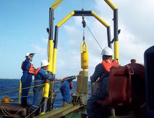
Gravity Corer

Gravity corer with piston 83 mm in
diameter and six (06) meters long. It has
a mass of 600 kg and can contain inside
a PVC tube where the sample will be
contained after taking it from the sea
floor. It has a removable tip that
facilitates penetration into the ground
and a stainless steel retainer designed to
cut the sample and keep it inside the
plastic sampling tube during recovery
when the sampler is raised with the winch, guaranteeing a minimum sample loss during
his ascension to deck.

Operating Depth                400 m

Max. Load                        6m

Sample Length                    6m

Sample Diameter                83 mm

Weight                         500 kg

                             Winch with
Deployment Method
                          hydrauliic central

                                                                                   9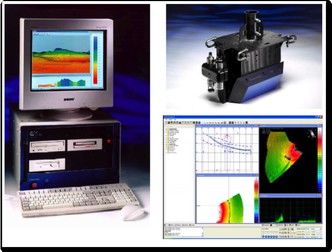
2021                    Equipments
                        High- Resolution Geophysics

       • Towed Arrays

       • Air Guns

       • Compressors

       • Registry System

       • Processing

       • Interpretation

                                                      10
Exploration Electronics Survey Equipment
Towed Arrays
Hydrophone Arrangements (Streamers)
Sercel SEAL up to 180 channels
DigiCourse levelers
Electric and hydraulic winches
Air Guns
Sercel G and GI from 30 to 840 cubic inches
Air and water guns SSI G. Draft guns TI
Compressors
Comp Air Reavell series 5000
Hamworthy series 70 mm
Registry System
Sercel SEAL 408XL
Geometrics Strata Visor and Geodes OYO DAS 1
11Geophysical Survey System. Exploration Electronics HR2D
Incostas, with the support of Exploration
Electronics of England, provides services for
High- Resolution Seismic Studies, offering
multichannel systems for the acquisition and
data processing.
The graphics show recent studies of High-
Resolution 2D Seismic in the Gulf of Paria,
yielding high quality data, with penetrations of
up to 1 second.
The system used consists of a compact 10
cubic inches air gun, a 200 m hydrophone
streamer, 36 channels and a GeoMetrics
StratavisorNX digital recorder. All data
were processed using the Focus 5 software
from Paradigm
12SeaSPY Marine Magnetometer
The Magnetometer SeaSPY Marine Magnetics is a equipment with an accuracy 0.1nT, the highest
accuracy on the market. It's a team built to a very high resistance able to work both in conjunction
with side scan sonar, as deployed alone.
Its low power consumption makes it ideal for operation in small boats. The operating principle is
based on the Overhauser effect, allowing you to acquire data in either direction and need not be
calibrated to the direction of the magnetic field in the area.
Its interface is very simple and allows it to be easily integrated with a sidescan sonar of any trademark.
Principle of operation: Overhauser Effect.
Range: 18,000 nT to 120,000 nT
Sensor sensitivity: 0,01 nT @ 10 samples by second
13GeoMetrics G-881 High-Resolution Cesium Marine Magnetometer
The GeoMetrics G-881 system has been
specially designed for the detection and
location of ferrous objects of any size.
In this devise the high-resolution
equipment that uses Cesium vapor
technology has been integrated and offers
all the advantages for conducting
surveys in
shallow waters. Its sensitivity is of 0,02 nT @
10 samples per second.
The system has an interface to be
connected to the GeoAcoustics Deep Tow
2000 system, allowing integrated capture
of incoming data from the Side Scan Sonar,
the GeoChirp Sub-Bottom Profiler and the
Magnetometer.
Operation Principle: Divided auto-oscillating beam of Cesium vapor (Cs133)
Operation Range: 20,000 nT to 100,000 nT
Sensibility: 0,02 nT @ 10 samples per second
142021 Equipments
Bottom Geophysical
Integrated Shallow Geophysics System
15GeoAcoustics Deep Tow 2000 System. Integrated system for marine bottom
geophysical data collection
The modular integration of the system All the information is multiplexed though a
allows the acquisition of data through the single coaxial cable.
combination of the signals coming from The storage, processing and control of the
the Double Frequency Side Scan Sonar, data is made through the Geopro 4
Chirp or Sub-Bottom Profiler, system, which also allows the follow up in
Magnetometer, Towfish tracking system, real time. The Geopro 4 also has the
orientation sensor and depth capacity to generate mosaics of the
determination system. marine bottom.
The telemetry unit system carries power,
signal and control over the towfish and its
components.
16GeoAcoustics Deep Tow 2000 System. Technical Specifications
Telemetry System 90-250 VAC, 50-60Hz, 500 W
Power 350 VDC ± 3 VDC
Power output to towfish 220-236 kHz (up)
Frequencies of the link 430-446 kHz (down)
Maximum cable length 10 Km of 11 mm armored coaxial cable
Cable Rochester A302799 or equivalent
GeoChirp II
Maximum Power Output 2 kW RMS
Pulses Width 16 o 32 ms (programmable)
Chirp Sweep Programmable
Penetration Up to 50 m, depending on the sediment
Frequency Range 1 kHz to 12 kHz
Control RS-232
Repetition Rate 8 per second with pulses of 16 ms
Transducers of Transmission 4 per second with pulses of 32 ms
Hydrophones 4 model 138D (2000 m)
Standard Chirp hydrophone tail
Side Scan Sonar
Dynamic Range Adjustable over 60dB range
TVG: -20 a +20dB
AGC: -34 dB
Mode operation at 100 kHz and 410 kHz
Output Power 3.0 kW and 2.5 kW ± 20%
Longitude of Pulse 167 ms and 88 ms ± 1%
Repetition Rate 20 pulses per second maximum
173k Hz – 7kHz Geophysical Sub-Bottom Profiler system from GeoAcoustics GeoPulse (High resolution, 10-
30 meters of de penetration), used for the location and measurement of buried pipelines, dredging
projects and Geotechnics complement.
GeoAcoustics GeoPulse Boomer & Sparker de 200kHz - 2kHz (Up to 125 meters of penetration), used to
complement the geotechnics.
18Side Scan Sonar
The GeoAcoustics Dual Frequency Side Scan Sonar
system is the ideal tool for seabed feature
mapping, offering high quality results in a simple
and reliable package. It offers switch selectable
dual frequency operation (114 / 410 kHz), which
when combined with multiplexed data
transmission enables a low-drag coaxial cable to be
used. The modular design makes it ideal for
combining it with GeoAcoustics GeoChirp and
GeoPulse sub-bottom profilers. The versatility, ease
of operation and reliability has made it a popular
choice for navies and commercial survey
companies alike.
System Components
The standard system employs a lightweight towed body (Model 159D), which is easily deployed by one
person. The fish houses a multiplexer (Model SS982), allowing data transmission over long cables, as well
as the two dual frequency transducers (model 196D port and starboard). The transceiver unit (model
SS981) outputs a signal compatible with all major acquisition systems.
The deck unit allows the operator a simple means to select operation parameters such as operating
frequency, Gain, Time Varying Gain (TVG) and Automatic Gain Control (AGC), with duplicated controls
for the port and starboard channel.
Features:
• 1000 m depth rating
• Switch selectable dual frequency (114/410 kHz)
• High bandwidth and resolution
• Multiplexed data transmission over long cables
• Easy to operate
• High reliability (MBTF > 10,000 hours)
• High efficiency / low power
• Simple maintenance
19Innomar’s SES-2000 compact Parametric Sub-Bottom Profiler for Shallow Water
• Very compact design for inshore
applications on small boats
• Power supply mains (110–240V) or DC
(battery 12V/24V)
• User-friendly system control and data
acquisition software with real-time
processing and echo print visualisation
(SESWIN)
• High spatial resolution due to narrow sound
beam, high ping rate and high bandwidth,
• Very narrow acoustic beam → high
horizontal resolution
• No side lobes for the LF beam
• High bandwidth
• User selectable sound pulse characteristics
(Ricker, CW)
• Data heave corrected (depending on heave
sensor data),
• HF (approx. 100kHz) echo sounder function for exact water depth determination
• Hull or pole mounted transducer → no towed items,
• Slave display of echo print and system parameters via Ethernet for QC / supervision
• Wide range of auxiliary sensors from different manufacturers (GPS, RPH) supported
• Synchronisation with other simultaneously operated acoustic systems possible to reduce
acoustic interferences (trigger in/output),
• Data acquisition (envelope and full waveform) with automatic backup on a central data server if
required.
• Data export to SEG-Y, XTF, ASCII,
• Optional ISE post-processing software with GIS module
20Pipeline Detection
Shallow gas Detection
212021 Equipments
Bathymetry & Topographic
Equipment and system for Bathymetry and Topographic data survey
22Marimatech E-Sea Sound MP35 33/200kHz
Echosounder
Odom Hydrotrac 33/200kHz. Echosounder
Other Equipments:
• Echosounder Garmin GPSMAP 235 50 - 200kHz.
• Laser Technology Impulse + Map Star. Rangefinder
• RTK L1+L2+Glonass GNSS devises
• Theodolites
• Fluxgate KVH C-100 electronic compass.
• Office and field informatics equipment - Garmin G.P.S.
• Oceanographic Software Hypack 8.1 – Diving equipment.
23GeoSwath+ Multibeam Echosounder
GeoSwath Plus offers very efficient
simultaneous swath bathymetry and
side scan seabed mapping with
accuracies that have been shown to
exceed the IHO Standards for
Hydrographic Surveys. The applied
phase measuring bathymetric sonar
technology provides data coverage
of up to 12 times the water depth,
giving unsurpassed survey
efficiency in shallow water INCOSTAS
environments.
MULTIBEAM BATHYMETRIC SURVEY EQUIPMENT
Features: GeoAcoustics GeoSwath of 125 kHz
Multibeam Echosounder (side scan).
High resolution Bathymetric scan
system.
• Ultra high resolution swathDual
bathymetry
transducers.
Coverage of up to 12x higher than the
• IHO SP-44, special order water depth.
Input and output interface of data and
• Co-registered geo-referenced side scan
other peripherals RS232 and USB.
• Software
Operation Frequency: 125kHz for data acquisition,
calibration, process and presentation.
• Up to 12 times water depthIncludes
coveragesensors for movement, course,
speed of sound.
• 240º view angle Receives GPS data position
Windows XP system.
• Interfaces to all customary peripheral sensors
• Interfaces to all customary software packages
• Dual transducer set-up with versatile mounting options
GeoSwath is a system for bathymetric
• surveys in
Full software solution included: data acquisition, processing, presentation shallow waters (up to ± 200
meters) offering a wide coverage of the
lateral beams (0.85°) up to 300 meters wide
by ran line and a very high resolution of 6
millimeters which allows guaranteeing 100%
coverage of the area surveyed with great
precision and reliability in a remarkably short
time in comparison with the simple beam
24
system.
Entirely digital record, processable and
printable.Topo-Bathymetric Surveys
Applications
• Port planning and marine structures
• Navigation
• Coastal structures planning
• Hydrodynamic studies
• Water quality studies
• Basic and Detailed Engineering of port and marine
structures
Equipments
• Echosounders of 24, 33 y 200 kHz
• Complete equipment of classic topography, laser
distance meter, etc.
• Positioning by Satellite Differential RTK Javad
Legacy L1+L2 + Glonass
• DGPS positioners
Software
• Hypack Software Hypack for computerized topo-
bathymetric survey execution with high precision
as well for horizontal as for vertical.
25INCOSTAS
TOPOGRAPHIC EQUIPMENT
Topographic Equipment
Wild Level, Model N2-A, Automatic Trimble connection cables for the
GPS antenna
Wild Level, Model N2, Reversible
• Bubble
Wild level, Model N2-A, Automatic • Pacific
TrimbleCrest cable connection,
connection cables for the GPS
model 24A WG/8
Theodolite Wild T2 (1”) antenna
• Wild Level, Model N2, reversible Bubble DCA 0537 Power cable
Wild Distance Meter, Model DI-20
• Trimble,
OMNI Total Base Station Model ZTS
GPS antenna micro-
• Theodolite
TOPCONWild
TotalT2Base
(1”) Station
(distance meter-theodolite), Model • centered, Ground
GPS Topcon, Plane
Legacy H type
GD Model
• Wild Distance Meter, Model DI-20
GTS-226, Intern Data Collector, 1” Trimble double frequency rover GPS
lecture Total Base Station (distance • with
Pacific crests
option cable connection, model
to RTK
• TOPCON
24AWG/8
meterTOPCON Total
Theodolite), BaseGTS-226,
Model Station Inter data Current cable
(distance meter-theodolite), Model
collector, 1” lecture • Belden datapower
DCA 0537 cable cable
GTS-105-N, Intern Data Collector, 5”
• lecture
GPS Novatel, Flexpak-SSI-5HZN Model • Trimble radio
Trimble, GPStransmitter RTK centered,
antenna micro
Trinmark II
GPS Topcon, Legacy H GD Model ground plane type
• GPS Topcon Legacy E Model Pacific Crest VBI radio receptors
GPS Novatel, Flexpak-SSI-5HZN
Model
• Sokkia
Trimble double frequency rover GPS with
Levels
• GPS Topcon Legacy Model
option to RTK Trinmark II
GPS Topcon Legacy E Model
• Radio MODEM Differential All equipment
equipment has their accessories as: tripods,
GPS Topcon Legacy Model All have their accessories
• Belden as: tripods,
rods, rods,
prisms, andprisms,
handbagshandbags.
RadioPower
MODEMCables M8205
Differential
Belden Power cables M8205
TOPCON TOTAL STATION TOPCON TOTAL STATION
MODEL GTS-105N MODEL GTS-226
OMNI TOTAL STATION MODEL
ZTS
26Bathymetric, topographic and geophysical data processing
• HYPACK for Windows, software for
navigation, Surrey and process of • Software for bathymetrical and
hydrographic Works Topographic information processing
developed by INCOSTAS
• AutoCAD 2011
• Software for visualization and analysis of
• COGO – Coordinate Geometry geophysical signals
• AdCADD Civil/Survey DTM - Digital • Wave prediction Software developed
by INCOSTAS
• Terrain Modeling
• Windows XP, Windows 2003 y Mac OS X
• Vectors Works 8.1 10.5, Work stations, equipped with
Microsoft Office, Project, Visual Basic,
• Statistical Package for Social Sciences etc.
(SPSS)
• Compaq, Apple, Toshiba, Lenovo field
• Simulation Language for Alternative portable computers
Modeling (SLAM)
• Software for spectral and statistical
• SMS analysis of tides
• ACES – Automated Coastal • GROW of OCEANWEATHER INC.
Engineering Systems Mathematical Model. GHOST & MAP of
TECNOCEAN. STWARE and ADCIRC
• GENESIS: Generalized model for
simulation shoreline change
272021
Equipments
Positioning & Navigation aids
Differential satellite positioning and navigation aids
28Applications
• Positioning of bathymetries, oceanographic Surrey
and geophysical Studies
• Navigation lines pre-plotting
• Piloting aids for vessels in navigation channel with
restrictions
• Geodetic surveys
SOFTWARE “HYPACK” PARA
NAVEGACIÓN Y POSICIONAMIENTO • Boring equipment Positioning
Equipments
L1+L2+ Glonass DGPS
Pacific Crest modems
Software
Hypack Software for navigation, monitoring,
processing and differential positioning aids in real
time.
Equipo DGPS Novatel
29Hemisphere GPS R120 DGPS
Rely on consistent sub-meter
performance with standard SBAS
differential and Hemisphere GPS’
exclusive COAST™ technology that
maintains accuracy during
temporary loss of differential signal.
The R100 offers many differential
correction options for various
environments and worldwide
coverage. The simple user interface
and extensive software features
make the R100 the ideal solution for professional mapping, guidance and navigation applications.
Features
• Feature-packed sub-60 cm DGPS Positioning Differential options including SBAS (WAAS, EGNOS,
etc.), Radio Beacon, OmniSTAR®
• Exclusive e-Dif® option where other differential correction signals are not practical
• COAST technology maintains accurate solutions for 40 minutes or more after loss of differential
signal
• Fast update rates of up to 20 times per second provide the best guidance and machine control
• Compatible with our exclusive L-Dif™and RTK technologies, for applications requiring higher
accuracy
• Uses a standard USB port for communication with PC
• The status lights and menu system make the R100 Series easy to monitor and configure
30Hemisphere Crescent VS101 Heading GPS
Precise applications demand the heading and
positioning performance of the VS101™ GPS
compass. Ideal for professional machine control
and navigation applications, the VS101 delivers
reliable accuracy at significantly less cost than
competitors’ products or traditional methods.
The Crescent® Vector™ II technology brings a
series of new features to the VS101 including
heave, pitch and roll output, and more robust
performance.
The VS101 receiver, with its display and user
interface, can be conveniently installed near the
operator. The two antennas are mounted
separately and with a user-determined separation to meet the desired accuracy. The VS101 uses SBAS
(WAAS, EGNOS, MSAS, etc.) for differential GPS positioning.
Features
• Affordable solution delivers 2D GPS heading accuracy better than 0.1 degree rms
• Differential positioning accuracy of less than 60 cm, 95% of the time
• Integrated gyro and tilt sensors deliver fast start-up times and provide heading updates during
temporary loss of GPS
• Fast heading and positioning output rates up to 20 Hz
• SBAS compatible (WAAS, EGNOS, MSAS etc.), and optional external differential input
• COAST™ technology maintains differentially corrected positioning for 40 minutes or more after
loss of differential signal
• The status lights and menu system make the VS101 series easy to monitor and configure
31CT-1 Cable Tracker System JW FISHERS
JWFishers Cable Tracker 1(CT-1) System was specifically designed to locate and track buried power and
communications cables. The system will locate cables buried on land or underwater.
The Cable Tracker 1 system consists of the Signal Injector control box and the Cable Tracker Probe. The
Signal Injector is attached to an exposed part of the cable on land and the detection probe is used to
continue the electromagnetic field generated along the cable length.
The working frequencies are 25.50, 60 y 1024 Hz.
Six internal AA rechargeable batteries power the Probe
allowing it to operate for 12 continuous hours.
CT-1 Signal Injector
Cabletracker Probe
32You can also read