2021 Update on the JPSS PGRR Tropical Cyclones Initiative - Monica Bozeman JPSS PGRR Tropical Cyclones Initiative Facilitator
←
→
Page content transcription
If your browser does not render page correctly, please read the page content below
2021 Update on the
JPSS PGRR Tropical
 Cyclones Initiative
               Monica Bozeman
  JPSS PGRR Tropical Cyclones Initiative Facilitator

                                        Interdepartmental Hurricane Conference
                                                                  March 2021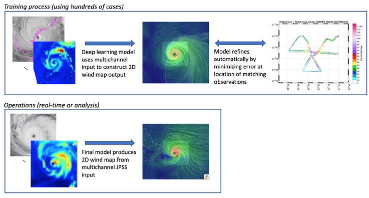
Outline

● Current uses of polar data in NHC operations
● Key takeaways from the 2020 Satellite Summit
● Incorporating ideas to increase the use of polar data in TC operations into the
  JPSS PGRR that satisfy key takeaways
● Brief on Currently Funded Projects
● Selected results from currently funded projects
● Brief on Upcoming Projects

                                                                                    2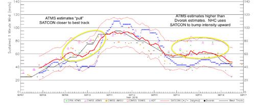
Current Uses of JPSS & Other Polar data in TC Ops

                                                                                     Night
     85-91 GHz            36-37 GHz                                                          Day

●   Microwave: Analysis of TC internal structure and center fixing within ATCF, Intensity and wind radii
    estimation algorithms from AMSU and ATMS, layered TPW products, used as input into statistical
    models
●   Scatterometers: Analysis of closed circulations for TC genesis, Wind radii estimates, TAFB use in
    gap flow wind events
●   Altimeters: Wave height estimates for marine forecasting, subsurface temperature structure for
    Oceanic Heat Content (OHC) for intensity forecasting as input into SHIPS model
●   Application of VIIRS Day Night Band (ProxyVis): CIRA trained on DNB and applied to
    Geostationary imagery
                                                                                                           3
Key Takeaways from the Feb 2020 GOESR-JPSS PGRR Satellite Summit
Satellite Summit Tropical Session - Feb 26th 2020 at NCWCP - College Park, MD
**Holding the Summit was determined to be a best practice for idea exchange between developers and operational users**
● Wider distribution of polar data from direct readout sites to reduce latency
● More integration of products into the operational workstations (AWIPS2, ATCF)
● Data providers should add metadata to datasets and work directly with
APO/TOWR-S to create AWIPS2 displays that utilize the sampling feature
● Developers have a hard time gathering feedback from
operations. Users need to work alongside developers to
strengthen interaction and collaboration on products
4Implementing Takeaways from the Satellite Summit into the PGRR:
Ideas to Increase JPSS Utilization in TC Operations
● Get data to forecasters faster - Processing of direct readout data to reduce latency
● Implement products into the operational infrastructure:
○ Implement GeoIPS directly into NHC-supported VMs
■ Reduces technical spin up
■ Easier facilitate R2O transition and IT support once fully operational
■ Use GeoIPS as the delivery mechanism for R2O algorithms and applications (use on WCOSS)
○ Continue to add JPSS data in AWIPS2 - leverage relationships with APO/CP and TOWR-S for their
AWIPS expertise
■ Process data into AWIPS2-friendly formats to provide more polar global coverage
■ Take output from NRL’s GeoIPS to design AWIPS displays that:
● Leverage sampling for quick access to metadata
● Reduce the number of products to load via combo/blended/mosaic products
● Developer-Forecaster collaboration:
○ Demo PGRR products to forecasters at the NHC “Lapenta Tropical-Marine Laboratory” and/or NHC
AWIPS Cloud Instance
5PGRR TC Projects & PIs: Current Projects (FY19-21)
Real-time acquisition, processing, analysis, and operational integration of TC-centric polar orbiting data:
Project Part I: Implementation of a data ingest, standardization, and output system
NRL: Josh Cossuth, Mindy Surratt
NRL GeoIPS is used to replace proprietary software that processes multiple data formats within a
common infrastructure to normalize satellite data and create TC-centered imagery
Project Part II: Serving forecasters with advanced satellite-based TC center-fixing and intensity information
CIMSS: Tony Wimmers, Derrick Herndon
Adapting ARCHER and SATCON algorithms into GeoIPS framework and using JPSS as input. Also
assisting forecasters to understand algorithm output with quick guides
Project Part III: Improving Tropical Cyclone Forecast Capabilities Using the JPSS data Suite
CIRA/NESDIS: Galina Chirkova, John Knaff
Development of multiple TC applications using JPSS input data to improve TC intensity forecasting
Collaboration with JPSS Soundings Group:
Understanding the Value of Real-Time NUCAPS Soundings for Hurricane Monitoring and Forecasting when paired with TC
Aircraft Reconnaissance missions
6NRL: Proof of Concept - Better Latency with Direct Readout
● NRL Geolocated Information Processing System (GeoIPS) is an open source Navy TC
processing suite for research and NRT operations
● GeoIPS at NHC now supports processing of JPSS Direct Readout (DRO) data
Latency example for GCOM-W1 AMSR2
● Preliminary NRL findings of JPSS DRO
compared to NESDIS PDA proves
substantial latency improvement more
conducive to operational timetables with
DRO!
DRO gets in ~24 mins earlier with Ascending pass
DRO gets in 86 mins earlier with Descending pass
7CIMSS: Adapting ARCHER & SATCON to JPSS Data
N-20 Day/Night
Band
● Adapted CIMSS’ ARCHER TC center-fixing algorithm to operate on JPSS imagery
which increases the sampling of TC measurement by including wider-swath
microwave sounders and supports more TC analysis algorithms to operate on
JPSS
N-20 183 GHz
N-20 89 GHz
● Added SNPP and N20 to the SATCON algorithm and assessing it’s impact to
SHIPS. SATCON is CIMSS’ ATMS-based ensemble estimate of TC intensity.
Both algorithms are being adapted into NRL’s Python-based GeoIPS framework
in order to be deployed to operational TC forecasting centers 80, 360 SNPP VIIRS
1625 UTC on 9/10/18
CIRA: TC Applications adapted to JPSS Data
@ NASA Worldview
1) TC monitoring with VIIRS by remapping onto the GOES-R projection & adding DNB 270 90
into the Geostationary ProxyVis nighttime imagery product
2) Extend IR-based eye detection and automated objective RMW (oRMW) estimation
algorithms to use MW data with ATMS and VIIRS IR channels 180
3) ATMS-MiRS moisture analysis and detection of dry air intrusions with MIST Pressure – Heading ATMS-
MIRS
VIIRS Day-Night Band Imagery remapped in RH at R = 0 - 1000 km for MIST
GOES-16 satellite projection Hurr Isaac at 1633 UTC on 09/10/2018
9PGRR TC Projects & PIs: Upcoming Projects (FY21-23)
1: Improvements to near-real time GeoIPS LEO data processing: Direct readout and AWIPS-2 integration into operations
NRL: Josh Cossuth, Chris Selman, Mindy Surratt
Build upon the currently funded project leveraging the NRL GeoIPS software to develop a common framework that normalizes polar
data and creates TC-centered products to enhance the local ability for R2O by the use of low latency direct-readout and NESDIS PDA
products in operational forecast interests. The project also intends to incorporate CIMSS algorithms into GeoIPS and provide input
into CIRA applications
2: Direct integration of JPSS observations into Tropical Cyclone surface wind structure retrievals using Deep Learning
CIMSS: Tony Wimmers, Derrick Herndon
Transition the Deep Learning model output (based on passive MW, JPSS imagery, and feature detection from CIMSS’ SATCON and ADT)
into NRL’s GeoIPS platform to reconstruct the entire TC 2D surface wind field and provide insight for use in operational forecasting of
TC intensity and analyzing structure
3: Use of JPSS Instrument Suite to Improve Operational Tropical Cyclone Structure and Intensity Analysis and Forecasts
CIRA/NESDIS: Galina Chirkova, Alex Libardoni, John Knaff
Continue development of funded Tropical Cyclone forecast applications, but focus on TC moisture analysis and Extratropical Transition:
1. The development of a new ATMS-MiRS moisture application to display storm-centered shear-relative TPW, moisture flux, and
vertical and azimuthal cross-sections of RH which will be added into the SHIPS model - (a JPSS expansion of the MIST tool)
2. Creation of storm-centered databases of ATMS-MiRS, NUCAPS, and VIIRS during TT/ET and used to develop warm core
applications to diagnose TT/ET and cyclone phase.
3. Additional training on CIRA’s ProxyVisible algorithm for ET in the northern latitudes and develop an imagery product for
forecasters
Follow up questions about the JPSS PGRR for TCs?
4: Continued Collaboration with JPSS PGRR Soundings Initiative Interested in joining our Stakeholder meeting on 3/16?
10
Email Monica.Bozeman@noaa.govBackup Slides
CIMSS Upcoming: Using Deep Learning to construct a 2D TC wind field

• Our 2021-2024 research
  effort will use deep
  learning to associate
  ATMS and VIIRS
  imagery to two-
  dimensional TC surface
  wind fields

• The motivation is that
  satellite imagery has
  uniquely detailed
  depictions of TC
  structures, and deep
  learning can be used to
  relate this to elusive
  inner-core wind patterns
                                          Follow up questions about the JPSS PGRR for TCs?
                                                 Email Monica.Bozeman@noaa.gov             12
You can also read


