2021 Virtual Port Meetings - Wednesday, March 24 - Oregon ...
←
→
Page content transcription
If your browser does not render page correctly, please read the page content below
OREGON FISHERMEN'S CABLE
                              COMMITTEE, INC.                        ©

                                                                                             March 2021
                               Undersea Cable Update                                     Volume 9, Issue 1

   2021 Virtual Port Meetings — Wednesday, March 24
                         TRAWLER OWNERS, CAPTAINS AND CREW
                              (Draggers, Shrimpers & Whiting Fleet)
Please give us 20 minutes of your time to share the new OFCC 9-minute training video and a quick
update on Oregon submarine cables, and you could win a $50 gift card from Englund Marine
Supply. Join the live meetings at https://bluejeans.com/5033252285/2285/webrtc (phone,
tablet or computer). This link will be emailed to everyone we have email addresses for. Please email
your address to staff@ofcc.com.
If you are at sea or don’t have a strong connection, you can dial in (audio only) 408.419.1715
Meeting ID: 503 325 2285 Passcode: 2285
Choose the time that works best for you on Wednesday, March 24 — 8:30 AM, 12 Noon, or
4:00 PM. A $50 Englund Marine gift card will be given away at each of those three times. There
will also be a second chance drawing for all non-winners after the last ‘Port Meeting.’
We will try to answer questions about the short-term deployment of seafloor seismic sensors offshore
Oregon, Washington, and British Columbia investigating geohazards in the Pacific Northwest
scheduled for late May through mid-July 2021. See article inside.

You can find the OFCC training video (and a shorter promo video) at OFCC VIDEO — YouTube.
Look for the 8:48 min. instructional film. The video was created to allow vessel owners to get the
information about safely fishing around cables to skippers and crew that are unable to attend our port
meetings. It provides some basics about the OFCC protocols which are designed to reduce fisher-
men’s liability and increase safety for fishermen and cables.

                  What? OFCC is giving away a $200 Cabela’s Card?
Owners and Skippers — We need your help to keep our boat/owner/skipper information up to
date!! Please check and update the stamped and addressed information card included with this
mailing and return it to us. If there are no changes, please write OK and return. All returned cards
will be entered into a drawing for a $200 Cabela’s gift card on April 8 — so fill it out now!

OFCC Version 11 Thumb Drive is available adding the as-
laid Jupiter Cable - Phase 1, starting approximately 3 ½ miles
offshore and going west. This outer portion of the Jupiter Ca-
ble was installed offshore of Sand Lake, north of Cape Kiwan-
da, in Summer 2020. Phase 2, installation to shore, is planned
for this spring. Ver. 11 includes plotter info for TimeZero,
Coastal Explorer, P-Sea WindPlot, ECC-Globe, OLEX, No-
beltec, and Maptech. This is the first new cable since 2018.
A thumb drive can be used numerous times and on multiple
boats. For help loading, please call Scott McMullen at
503.440.3569.
Page 2 U n d e r s e a C a b l e U p d a t e
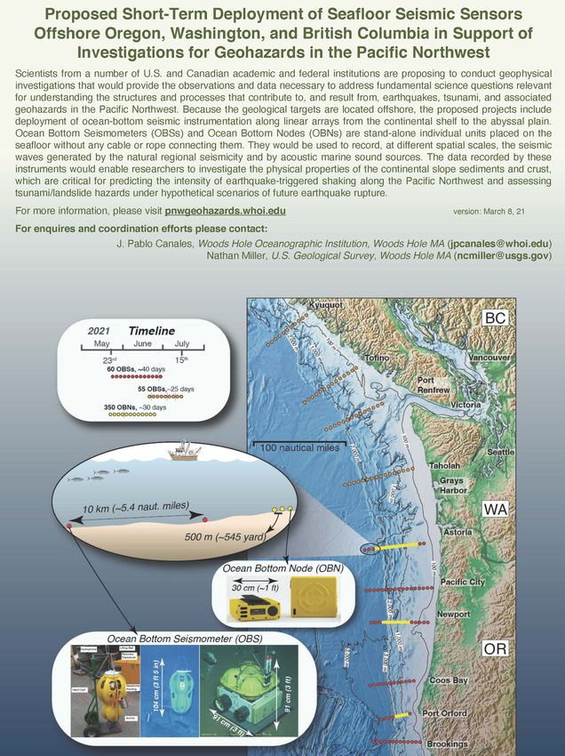
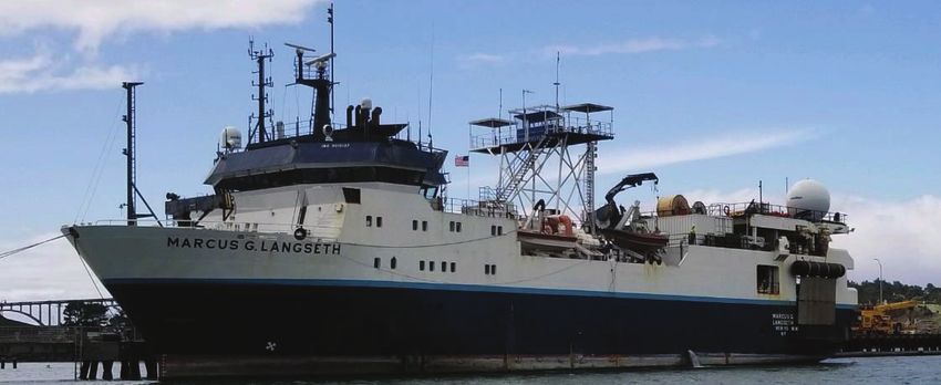
Caution! Please Avoid Seafloor Science OBSs (red and orange dots on graphic) will be
Instruments Between May 23 and July 1! spaced 8 to 10 km apart (approx. 5 naut. miles).
Scientists from Woods Hole Oceanographic They are 3 ft to 3 1/2 ft tall with a steel plate an-
Institution and partners will conduct a seismic chor that is 3 ft by 3 ft and approximately 2 inches
survey off OR, WA and BC, in May. R/V Oceanus thick. The anchor is a grid — not a solid plate —
will deploy receivers on the seabed in offshore so should sink into sediment a bit.
lines, and then the R/V Langseth will cruise over A total of 60 OBSs will be on the ocean floor off
the instruments trailing air guns and hydrophones Oregon (Brookings, Port Orford, Coos Bay, New-
recording the echoes from the percussions. The R/V port, Pacific City and Astoria) between May 24
Langseth will typically make one pass and move on and July 1. (Between June 24 and July 12 there
while the R/V Oceanus will recover the seabed will be 55 OBS off Cape Elizabeth and Vancou-
instruments, which also recorded the echoes. ver Island.) These dates are approximate and
weather dependent.
OBNs (yellow dots on graphic) will be spaced
about every 545 yards off the Alsea River, The OFCC is being contracted to plot locations of
Tillamook Hd, and Port Orford starting May 23. the 465 seafloor seismic sensors in six marine
The 350 units will be recovered by June 19. navigation software formats and arrange for
OBNs are approximately 1 foot square and less than thumb drives with all the data. We will make
6” high. The node arrays will be from 71 fm to thumb drives available for PSea WindPlot,
1640 fm deep. Coastal Explorer, TimeZero, Nobeltec Visual
Navigation Suite, ECC Globe, and OLEX.
Woods Hole asks that you please avoid these
Ocean hazards during the stated dates. These instru-
Bottom Node ments do not pose a huge risk to your vessels or
(OBN) — gear, but there is a large risk to the instruments.
yellow dots at An effort was made to put many instruments in
right EFH areas, but they could not avoid trawl grounds
entirely. If you pick up a node or seismometer in
your gear, do NOT throw it back overboard.
Please bring it to port and follow the instruc-
tions on the instrument to arrange for pick up.
Two styles of Ocean
Bottom Seismometers
(OBSs) — orange and
red dots on graphic at
right.
V o l u m e 9 , I s s u e 1 Page 3
SAVE THIS PAGE ON YOUR BOAT

                                                 OFCC
                                      2021 Marine Dr. Suite 102
                                         Astoria, OR 97103
                                       Phone: (503) 325-2285
                                     E-mail: smcmullen@ofcc.com
                                           staff@ofcc.com

The Oregon Fishermen’s Cable Committee Inc. is an organization of trawl fishermen and representatives from
companies that operate fiber optic cables off the Oregon coast. Membership is free of charge and open to all
west coast trawl fishermen that have either a west coast federal groundfish permit or an
Oregon, Washington or California Pink Shrimp permit. Members that follow operating protocols receive
replacement gear and compensation for lost time and catch if asked to sacrifice fishing gear to protect an
undersea cable. In addition, such members may receive a release of liability for accidental damage to an
undersea cable. Members also are eligible to participate in drawings for patrol vessel charter opportunities
during undersea cable installations. To join, contact the OFCC office.

               The OFCC tries to monitor an email address and phone number for use in a
                                    submarine cable emergency:
           OFCC Emergency phone #: (503) 440-3569 Email: 911@ofcc.com
                            Emergency Contacts for Possible Cable Hang-ups

           CABLE                      EMERGENCY EMAIL                 CABLE OWNER          EMERGENCY #
                              When you can’t call the Emergency #
AUFS-W                       nocc2@gci.com                                  GCI           (888) 442-8662

TGN SEGMENTS 1, 5, 6         nmcwall@tatacommunications.com                TATA           (732) 282-4001

OOI RCA SEG 1, 2, 3, 4, 5    ooi-ofcc@uw.edu                           WOODS HOLE         (855) 665-1424

NORTHSTAR
                             acscsnocc@acsalaska.com                        ACS            (888) 734-1888
AKORN

TRANS-PACIFIC EXPRESS
                             acscsnocc@acsalaska.com                      VERIZON         (888) 734-1888
(TPE)
SOUTHERN CROSS               acscsnocc@acsalaska.com                      VERIZON         (888) 734-1888

JUPITER                      JupiterOregon@fb.com                       FACEBOOK          (855) 956-3222

NEW CROSS PACIFIC (NCP) NCPSubsea@Centurylink.com                       MICROSOFT         (844) 278-6966

HAWAIKI (HAW)                ofcc@hawaikicable.co.nz                     HAWAIKI          (877) 242-9245

                                                                                          (866) 466-2288,
TPC-5 CABLES                                                               AT&T
                                                                                             prompt 5

FASTER                       FASTER-NOC@kddia.com                         GOOGLE          (877) 520-0800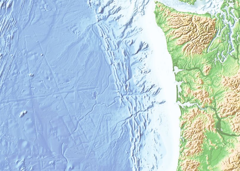
Proposed Marine Seismic Survey offshore Oregon, Washington, and British Columbia in Support of
Investigations for Geohazards in the Pacific Northwest
Scientists from a number of U.S. and Canadian academic and federal institutions are proposing to conduct geophysical
investigations of the Cascadia subduction zone from Southern Oregon to British Columbia, within the region where “giant”
earthquakes have occurred in the past along the fault zone between the oceanic Juan de Fuca plate and the North Ameri-
ca continent. The portion of the fault zone that generates the largest earthquakes is located almost entirely offshore and
marine surveys are needed to investigate its structure. The proposed investigations would use the scientific research
vessel (RV) Langseth to collect modern deep penetration 2-D marine seismic reflection data using an acoustic sound
source array and a hydrophone streamer and will be coordinated with concurrent marine and land deployments of
seismometers. This scientific equipment would be towed behind the ship along predetermined lines extending from ~6-12
miles to ~62-124 miles offshore from southern Oregon to Vancouver Island. The acquired data would be used to construct
detailed images and constrain physical properties of the slowly deforming sediments of the continental shelf and slope that
lie above the earthquake-generating fault, the fault zone itself, and deep into the subducting oceanic crust below. The
proposed survey would provide the observations and data necessary to address fundamental science questions relevant
for understanding the structures and processes that contribute to, and result from, earthquakes, tsunami, and their
geohazards in the heavily populated Pacific Northwest. The proposed study would be the first such regional-scale seismic
imaging investigation ever conducted spanning nearly the entire length of the Cascadia Subduction Zone and would move
the region from arguably one of the least well characterized heavily populated megathrust regions in the world to one of
the best.
For more information, please visit pnwgeohazards.whoi.edu.
For enquires and coordination efforts please contact: Suzanne Carbotte, Columbia University, New York (carbotte@ldeo.-
columbia.edu) J. Pablo Canales, Woods Hole Oceanographic Institution, Woods Hole MA (jpcanales@whoi.edu)
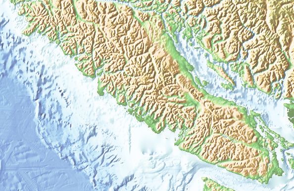
Kyuquot
2,0 BC
Survey
10
00
0
1,0
m
m
Tofino Vancouver
00
Goals
m
Port
Renfrew
Victoria
100
m
Seattle
2,0
00
Timeline
m
Taholah
2021 Grays
01-May 01-June 01-July 01-August Harbor
1,000 m
WA
S of ~Astoria (~25 days)
Astoria
N of ~Astoria (~15 days)
Garibaldi
100 m
Pacific City
Deboe Bay
Equipment
2,000 m
100 nautical miles Newport
8 nmile
1,000
Florence
39 feet OR
m
WinchesterBay
Coos Bay
Bandon
Port Orford
Gold Beach
Brookings
HEADS-UP—GEOHAZARDS RESEARCH
There will be an expansive research project off the coast of Oregon, Washington and British Columbia. The
purpose is to characterize the Cascadia Subduction Zone to better understand the threat of subduction zone
quakes and tsunamis. This is a very large project, but it has a relatively short duration, and the researchers
request your help. Here is what is happening:                                                        OBS
Around May 23rd, the RV Oceanus will leave Newport and lay 3 lines of Ocean Bottom
Nodes (OBN), small receivers that are about 12” x 12” x 6” and weigh 46 lbs. These will
be set on the seafloor in straight lines by an ROV, approximately 545 yards apart, off
Tillamook Head (180 nodes) , South Beach (106), and Port Orford (64). A second type of
receiver, an Ocean Bottom Seismometer (OBS) will also be deployed by the RV Oceanus
                                                   at the same time, at the beginning and
                                                   end of the OBN lines, as well as other
                                                   lines at Brookings, Coos Bay, Pacific City,
                                                   and Cape Elizabeth (and off Vancouver
                                                   Island). These larger OBS receivers will be around 5 nm
                                                   apart. All of these devices will be plotted in popular marine
                                                   navigation software programs, available from the OFCC.
After these receivers are laid out, around June 1st, a seismic research ship, the RV Marcus Langseth, will make
transits across the shelf, slope and offshore over the receivers as well as other lines between the receivers.
The Langseth will be towing air guns to produce the sound waves. She will also be towing a hydrophone
streamer that will be about 39’ feet below the surface. She will be towing at about 4.5 knots. This streamer is
8 nm long and has a surface tail buoy at the end. The Langseth will be extremely limited in her ability to
maneuver and asks that no vessels pass between the ship and the tail buoy. Seismic ship operations should
be completed by July 10th.
After the ship has passed over a line of receivers, the RV Oceanus will recover the devices. Recovery of the
small OBN will be slow, as they will be picked up like they were deployed, by an ROV crawling across the
seafloor. The OBN doesn’t have any signal to home in on—the ROV will move across the seafloor picking them
up and setting them in a rack on the ROV. All OBNs (yellow dots) should be recovered by June 19 th and OBSs
should be recovered by July 12th.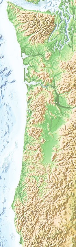
You can also read