22 Duirinish Wild Land Area
←
→
Page content transcription
If your browser does not render page correctly, please read the page content below

Description of Wild Land Area – 2017

22
        Duirinish
      Wild Land Area

                      1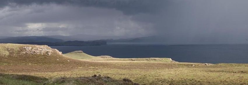
Description of Wild Land Area – 2017

 Context

Duirinish is one of the 11 island Wild Land Areas (WLA), one of two on the Isle of Skye. At 43 km2 it is
one of the smallest nationally, located in the far north of the island near to the settlements of Dunvegan
and Orabost. One of 12 WLAs defined in part by the coast, access from the road is largely restricted to
the north and east.
The area comprises a range of rugged hills and peatland that have a horizontal emphasis and adjoin the
coast with very high and dramatic vertical cliffs. This reflects the geology of the area which is described
as a stepped or trap landscape, formed of hard basalt laid down by successive lava flows from past
volcanos. Along the coast, the cliffs display active erosion by the sea, with a sequence of headlands and
inlets, as well as stacks, arches and geos.
The WLA is uninhabited and the land is managed mainly for stock grazingi, influenced by the objectives
of the community owned Glendale Estateii in which the area mainly lies.
The area is clearly visible from the sea on the west, viewed by those in boats and sea kayaks. In contrast,
it cannot be seen from most of the surrounding settlements and roads to the north, east and south,
although the far east and northern hill edge of the WLA forms part of the skyline to views from these
locations.
Duirinish attracts a number of visitors, although considerably fewer than some other parts of Skye.
These include hillwalkers (and a few mountain bikers) who ascend Macleod’s Tables (Healabhal Mhòr
and Healabhal Bheag)iii or take the popular path from Orbost to Idrigill Point, including viewing
Macleod's Maidens – three prominent sea stacks to the west of the Point. Smaller numbers also walk
what is claimed by some as ‘the most dramatic cliff-top walk in Britain’iv all the way between Orbost and
Ramasaig, including a stay for some at Ollisdal MBA bothy. Elsewhere, apart from a route in from
Glendale, there are no other paths into the WLA, so that access is off-path and physically challenging.
The whole of the WLA is located within the North West Skye Special landscape Area that recognises its
scenic value. Its descriptionv highlights ‘The dynamic composition between land, sea and sky creates an
ever-changing sequence of dramatic coastal panoramas…’as well as the importance of landmarks such as
Macleod’s Tables and Maidens.
The edge of this WLA is marked by the sea to the south west, forest plantations to the south east and by
public roads, crofts and settlement within an arc around the north. Further afield, its qualities are also
influenced by distant views around Lochs Dunvegan and Bracadale.

                                                        2
Description of Wild Land Area – 2017
Key attributes and qualities of the wild land area
A dramatic coastal edge dominated by natural features, open views across the sea and
exposure to dynamic weather conditions
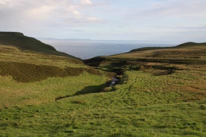
No part of this WLA is far from the sea, and this contributes strongly to the qualities of wild land across
the whole area, particularly the remoteness and sense of naturalness, and increasing the perceived
extent of the area.
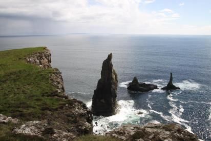
The coast is awe-inspiring in its combination of natural features along a scalloped edge of headlands and
bays, which include high towering cliffs, stacks, arches, geos, the open sea and views to islands – all
emphasising the sense of naturalness. The rocky and rugged nature of these features is often
highlighted against the cliff top vegetation that usually comprises a brightly-coloured short mat of grass.
The height and steepness of the cliffs mean access is limited and there is perceived high risk – both from
land and sea.
The cliff tops offer open, elevated and panoramic views with
an overriding sense of exposure. Promontories such as Idrigill
Point reach out like fingers into the sea, and their tips seem
isolated and precipitous with arresting cliffs dropping below
and sea birds circling around - the sea being stronger than the
land in influence. From these landform projections, it is
possible to gain views along the coastline to cliff faces, beaches
and waves that contribute to the sense of naturalness; in
contrast, from other locations, these views are screened by the
very steepness of the cliffs dropping away below.
Coastal geomorphological features convey a dynamic nature, for example with collapsed arches,
precarious-looking stacks and land slips, which contribute to the sense of naturalness. This is also
amplified by exposure to changing weather conditions.
Where glens and gentler moorland slopes meet the coast, for example at Ollisdal, access is easier and
there is often evidence of past inhabitation and crofting, such as old stone buildings or enclosures.
Although clearly visible as human artefacts, the isolation, discrete siting and low-key character of these
features means they tend to have localised effects.
3
Description of Wild Land Area – 2017
Extensive inland peatland, with a stepped landform profile that rises to awe-inspiring
distinctive hills and strongly influences accessibility
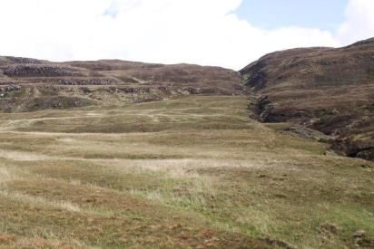
The stepped landform profile that extends over most of the WLA reflects very clearly the underlying
geology of basalt layers, highlighted by the rocky cliffs of the step ‘risers’ and the flat vegetated shelves
of the step ‘treads’, contributing strongly to the sense of naturalness. The individual steps vary in height
and width; however, they gradually build inland to form distinctive hills.
The stepped landform profile results in a contrast of steepness
and access, as climbing the rugged step edges is physically
challenging, whilst movement over the step ledges tends to be
less demanding.
This profile also results in a contrast of ground conditions. The
flat or gently sloped surfaces of the steps tend to be fairly
boggy with some peat hags, whilst the step edges are better
drained with rocky faces, sometimes including gorges and
waterfalls cut through their edge. All these features emphasise
the distinctive landform and contribute to the sense of
naturalness. Within this composition, there is very little native
woodland apart from the north eastern slopes of Ben Corkeval.
Away from the coastal edge, within the inland expanse of
peatland, it can be difficult to estimate scale and orientate due
to the simplicity of the vegetation and repetitive landform,
increasing perceived risk.
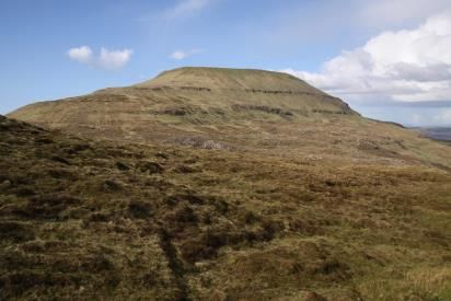
The stepped peatland hills tend to be fairly similar in elevation
and irregular in layout. However some stand out due to their
greater height and isolation – the most prominent of these
being Healabhal Mhòr and Healabhal Bheag, also known as
Macleod’s Table North and Macleod’s Table South. These have
strong landmark qualities due to their unusual form, with very
steep sides and flat tops that appear awe inspiring in shape,
elevation and their expression of the distinct geology of the
area.
The form of the Tables is often not clear from below, due to
screening by intervening landform shelves; instead, their
profile tends to be easier to see from a distance and/ or across
surrounding open water outside the WLA.
The Tables are physically challenging to ascend due to their
steepness; but, from their tops, they offer panoramic views
without any obstructions due to the sheer drop around them.
To the south west, they reveal the openness of the stepped
peatland interior that extends all the way to the coast and has
a prevailing absence of human elements. In contrast, because
the tops are located on the eastern edge of the WLA, views in
other directions include human artefacts and contemporary
land use such as settlement around Lochs Dunvegan and
Bracadale and some forest plantations, powerlines, and wind
farms upon the higher ground above these.
With the focus of access and land management around the coast, the inland stepped peatland has a
prevailing absence of human artefacts and contemporary land use which, in combination with
remoteness and few visitors or paths, results in a strong sense of sanctuary and solitude. There are,
however, some isolated locations with evidence of past settlement and cultivation, for example ruined
4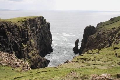
Description of Wild Land Area – 2017

shielings, enclosure walls and feannagan, as well as more recent elements such as a stock fence through
Glen Lorgasdal.
In contrast to these isolated elements, the ruined crofting
settlement of Lorgill comprises an extensive range of features,
including ruined croft houses and enclosure walls, fences and
high numbers of sheep, as well as a track to the north west.
This number and extent of human elements and evidence of
human activity diminishes locally the wild land attributes
within this particular glen.

Endnotes and select references
i
     Information at http://www.caledonia.org.uk/socialland/glendale.htm states the farm currently has 3000 sheep and 50 cattle
ii
      Information available at: http://www.glendaleestate.co.uk/glendale-land.html
iii
      Information available at: http://www.walkhighlands.co.uk/skye/macleodstables.shtml
iv
      Information available at: http://www.walkhighlands.co.uk/skye/ramasaigorbost.shtml
v
      The Highland Council (2011) Assessment of Highland Special Landscape Areas. Inverness, The Highland Council.

Site assessment carried out May 2014

                                                                   5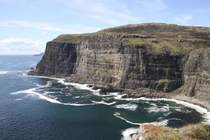
You can also read