2400 years of climate and human-induced environmental change recorded in sediments of Lake Młynek in northern Poland - CP
←
→
Page content transcription
If your browser does not render page correctly, please read the page content below
Clim. Past, 17, 1181–1198, 2021
https://doi.org/10.5194/cp-17-1181-2021
© Author(s) 2021. This work is distributed under
the Creative Commons Attribution 4.0 License.

2400 years of climate and human-induced environmental change
recorded in sediments of Lake Młynek in northern Poland
Fabian Welc1 , Jerzy Nitychoruk2 , Leszek Marks3 , Krzysztof Bińka3 , Anna Rogóż-Matyszczak2 , Milena Obremska4 ,
and Abdelfattah Zalat5
1 Institute of Archaeology, Cardinal Stefan Wyszynski University in Warsaw, Warsaw, Poland
2 Faculty  of Economic and Technical Sciences, Pope John Paul II State Higher School of Education, Biała Podlaska, Poland
3 Faculty of Geology, University of Warsaw, Warsaw, Poland
4 Institute of Geological Sciences, Polish Academy of Sciences, Warsaw, Poland
5 Faculty of Science, Tanta University, Tanta, Egypt

Correspondence: Fabian Welc (f.welc@uksw.edu.pl)

Received: 22 March 2020 – Discussion started: 30 June 2020
Revised: 7 April 2021 – Accepted: 6 May 2021 – Published: 14 June 2021

Abstract. In the densely forested Warmia and Masuria re-         likely overprints any signals of climate-driven environmental
gion (northern Poland) there are many small endorheic lakes      changes.
characterized by their low sedimentation rate, which makes
them excellent archives of Holocene environmental and
palaeoclimatic change. Lake Młynek, located near the village
of Janiki Wielkie, was selected for multi-faceted palaeoenvi-    1   Introduction
ronmental research supported with radiocarbon dates. Sedi-
ments from this lake also contain unique information about       Lake sediments are a useful source of proxies of past envi-
human impact on the environment, because a stronghold has        ronmental and climate changes in the Holocene (see Brauer,
been operating on its northern shore since the early Iron Age    2004; Brauer et al., 2009; Zolitschka, 2007; Wanner et al.,
to the early Medieval period, giving the opportunity to cor-     2008; Francus et al., 2013; Ojala et al., 2013; Welc, 2017).
relate palaeoenvironmental data with the phases of human         The main advantage of lakes for environmental reconstruc-
activity over the last 2400 years. During the second and third   tion is the continuous and uninterrupted accumulation of
centuries BCE the lake was surrounded by a dense deciduous       their sediments. Well-dated lake sedimentary records allow
forest. From the first century BCE to second century CE the      for tracing of both long- and short-term climate changes
forest around the lake was much reduced, which can be asso-      in the Holocene (Smol et al., 2001; Tiljander et al., 2002;
ciated with the first pre-Roman (La Tène) and Roman occu-        Valpola and Ojala, 2006; Czymzik et al., 2010; Elbert et al.,
pation phase evidenced by the construction of the stronghold     2012; Tylmann et al., 2012; Welc, 2017). Particularly valu-
located close to the lake. From the second up to ninth cen-      able for palaeoclimate reconstructions are sequences from
tury CE gradual restoration of the forest and a decline in       lakes without river inflow and outflow (Wetzel, 2001; Stanke-
human activity took place, along with lake deepening and         vica et al., 2015). As in most of Europe, many lakes in Poland
the onset of a colder and humid climatic phase which corre-      have been heavily impacted by human activities within their
sponded to the global cooling episode known as the Bond 1        catchments, resulting in many of them becoming eutrophic
event (1.5 ka BP). The next intensive phase of forest clear-     in terms of their nutrient status (Cooke et al., 2005). Such
ing around the lake occurred between the 9th–13th century        intensive bio-productivity arising from nutrient enrichment
CE as result of human activity (Middle Age settlement phase      results in the deposition of thick organic sedimentary se-
of the stronghold). Whilst this period is marked by a warm-      quences, mostly of organic gyttja composed of the remains of
ing, the human impact which has transformed the landscape        aquatic plants, plankton and benthic organisms transformed
                                                                 by bacteria and mixed with mineral components supplied

Published by Copernicus Publications on behalf of the European Geosciences Union.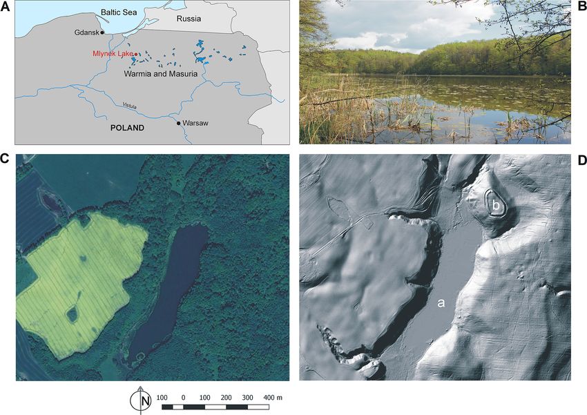
1182                                     F. Welc et al.: 2400 years of climate change recorded in sediments of Lake Młynek

from the lake basin (Stankevica et al., 2015). There are ca.      tats, a highly productive mixed forest prevails. The basic
1000 freshwater lakes of different sizes in the Warmia and        components of the Iława forest are pine (Pinus), oak (Quer-
Mazury region in northern Poland (Fig. 1). Most of them are       cus), beech (Fagus), alder (Alnus) and birch (Betula), and in
located within past glacial tunnel valleys formed by meltwa-      smaller amounts there are spruce (Picea), larch (Larix), ash
ter erosion at the termination of the Vistulian (Weichselian)     (Fraxinus), hornbeam (Carpinus), maple (Acer) and linden
glaciation (ca. 115–12 ka BP). After deglaciation at the end      (Tilia). Currently, the lake sits in a catchment that is charac-
of the Pleistocene these glacial tunnel valleys were partly       terized by a transitional climate with an influence from con-
filled with deposits and water, which persisted throughout the    tinental and maritime circulation. The growing season lasts
Holocene. Such lake basins have steep slopes and their bot-       about 206 d, and the snow cover remains for 70–90 d. Av-
tom deposits are underlain by either glaciofluvial sand, gravel   erage temperature values range from approximately −4.0 ◦ C
and silt or glacial till (Kondracki, 2002; Gałazka,
                                                  ˛     2009).    in February to above 17.0 ◦ C in July. Due to significant in-
Many of these lakes are small (< 1 ha), with stable sedi-         fluence of the polar air masses and a large number of natural
mentation rates and without river inflow or outflow making        water reservoirs, air humidity is relatively high, ranging from
them excellent sites for palaeoclimate reconstructions. In-       72 % to 89 %. Total annual precipitation ranges from 500 to
deed, most of the climate reconstruction studies based mainly     550 mm yr−1 . South-western winds dominate throughout the
on pollen analysis are undertaken in this area (e.g. Kupry-       year, with westerly winds stronger in winter and the highest
janowicz, 2008; Kołaczek et al., 2013).                           wind speeds recorded during the winter months (Jutrzenka-
    Lake Młynek is located near the village of Janiki Wielkie     Trzebiatowski et al., 1997; Stopa-Boryczka at al., 2013). It is
and was selected for multi-faceted palaeoenvironmental re-        important to note that from the north a small stream flows
search (pollen analysis, diatom, chrysophyte cysts and geo-       into the lake Młynek, which is active in winter and dries
chemistry). It is hypothesized that the bottom sediments of       up almost completely in summer (Fig. 1D). The stream is
this lake contain a unique record of human impact on the          a result of irrigation related to the construction of a mill in
surrounding environment, as a result of the location of an        the 15th century, somewhere in the vicinity of the medieval
Iron Age stronghold on the northern shore, which was active       stronghold located on the northern shore of the lake (Semrau,
(though not continuously) up until the early Middle Ages          1939; Bińka et al., 2020).
(Fig. 1). Due to archaeological research, stratigraphic units
distinguished on this site were divided into seven main settle-
                                                                  3     Material and methods
ment phases: early Iron Age (I), stronghold abandoned after
the early Iron Age (II), early Middle Ages (III), stronghold      3.1    Bathymetry
abandoned in the early Middle Ages (IV), settlement activity
in the 11th–13th centuries (V), stronghold definitely aban-       The determination of lake bathymetry and thickness of bot-
doned in the 14th century (VI) (Nitychoruk and Welc, 2017;        tom sediments is extremely important in palaeolimnologi-
Rabiega et al., 2017).                                            cal research to help locate appropriate coring sites. This can
    This study provides an opportunity to reconstruct the         be achieved through the use of GPR sounding (Lin et al.,
transformation of the vegetation around the lake that oc-         2009; Sambuelli et al., 2009; Sambuelli and Silvia, 2012). In
curred under the influence of the climate (regional signifi-      Poland, winter is a particularly convenient season as the lake
cance) and as a result of human activity. Our results were        is covered with ice, making GPR profiling much easier and
correlated with geoarchaeological data to determine mutual        improving access and the speed of data collection (Hunter
relations between environmental and climatic changes with         et al., 2003). Measurements along and across the lake were
development of human settlement phases in the Warmia and          carried out in 2017, directly on the lake ice (Fig. 2). We
Mazury (northern Poland) region during the last 2400 years.       used the radar system ProEx of the Malå Geoscience (http://
                                                                  www.malagpr.com.au/mala-professional-explorer.html, last
                                                                  access: 23 May 2021). A radar pulse was generated at a reg-
2   Study area                                                    ular distance interval of 0.02 m (900 samples were recorded
                                                                  from a single pulse). The time window of recording was be-
Lake Młynek is a small water body that occupies a glacial         tween 250 and 300 ns. Prospection was done with use of
tunnel valley since the Holocene. The lake is located in the      a shielded monostatic antenna with 250 MHz nominal fre-
Iława Lakeland in northern Poland, it is about 720 m long and     quency of the electromagnetic wave.
165 m wide. The lake has an area of 7.5 ha, with its water
level at ∼ 101 m a.s.l., and the maximum depth is just over       3.2    Coring and sampling
2 m. Lake Młynek is surrounded by a morainic plateau at
120–130 m a.s.l, and its catchment is occupied by a dense         Based on the results of the GPR sounding, four drillings
forest (Fig. 1). In general, most of the Ilawa Lakeland is        were undertaken a ca. 2 m water depth (Fig. 3) following
covered with forest (41.5 %), whereas meadows and synan-          the Givelet et al. (2004) collecting protocol. A piston
thropic communities have a smaller share. Among the habi-         sampler was used during drilling, which is very suitable

Clim. Past, 17, 1181–1198, 2021                                                       https://doi.org/10.5194/cp-17-1181-2021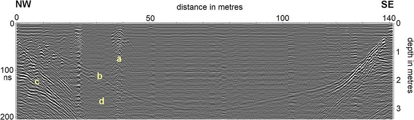
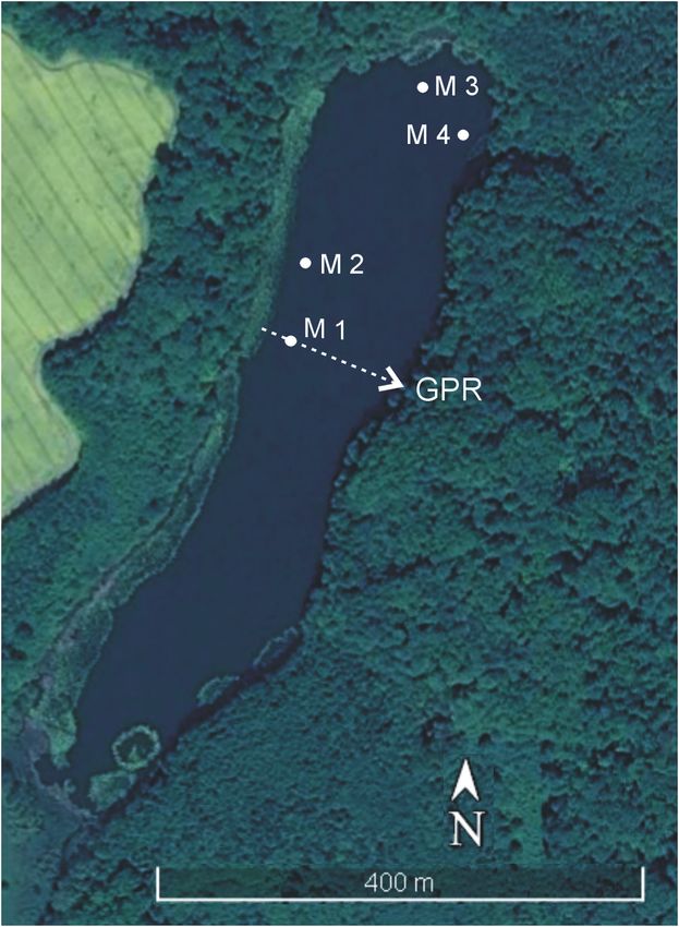
F. Welc et al.: 2400 years of climate change recorded in sediments of Lake Młynek                                                         1183

Figure 1. (A) Location of Lake Młynek in the Warmia and Mazury Region (north-eastern Poland) (drawing: Fabian Welc). (B) View of
Młynek Lake from the north-west (photo: Fabian Welc). (C) Satellite image of the lake (open source: © Google Earth: http://www.google.
com/intl/pl/earth, last access: 10 June 2021). (D) Lidar image of the lake: (a) lake basin, (b) Janiki Wielkie archaeological site established in
early Iron Age (© Geoportal Poland: http://www.geoportal.gov.pl, last access: 10 June 2021).

Figure 2. GPR reflection profile across Lake Młynek (see Fig. 2): (a) drilling M1, (b) upper boundary of the so-called hard bottom, (c) strat-
ified glaciofluvial sandy-gravel beds beneath the lake sediments, (d) attenuation zone of electromagnetic waves connected with occurrence
of organic sediment (gyttja) (measurements, processing and interpretation: Fabian Welc).

for sampling in moderately cohesive sediments to a depth                   (M1 to M4) were then subjected to magnetic susceptibility
of 5 m. The sampler set consists of a 200 cm long sonde,                   measurements which enabled the selection of the core
which is constructed from a thin-walled, 40 mm diameter,                   M1, the longest and most continuous, to carry out detailed
stainless steel tube (https://en.eijkelkamp.com/products/                  analysis. The 3.5 m long core M1 (geographic coordi-
sediment-samplers/Piston-Sampler-set.html, last access:                    nates: 53.82486◦ N, 19.72419◦ E) was sub-sampled at 5 cm
10 June 2021). Sediment cores were film-wrapped in 1 m                     intervals and used for multi-proxy laboratory analyses.
plastic tubes and transported to the laboratory. The cores

https://doi.org/10.5194/cp-17-1181-2021                                                                  Clim. Past, 17, 1181–1198, 2021
1184                                     F. Welc et al.: 2400 years of climate change recorded in sediments of Lake Młynek

                                                                   ness, which was set at 0.05 cm given the length of this core.
                                                                   The Bacon software uses the IntCal3 curve (Reimer et al.,
                                                                   2013) to calibrate the radiocarbon data.

                                                                   3.5     Palaeobotanical analysis
                                                                   3.5.1    Pollen
                                                                   The core M1 was sampled every 5 cm for pollen analysis. A
                                                                   total of 70 samples (ca. 10 g each) were treated with 5 % HCl
                                                                   and boiled in 5 % KOH and hot 30 % Hf. They were washed
                                                                   with 15 % HCl and treated by the standard Erdtman’s acetol-
                                                                   ysis. In each sample about 1000 pollen grains were counted
                                                                   using an optical microscope at 400× magnification.

                                                                   3.5.2    Diatom and chrysophyte cyst analysis
                                                                   A total of 70 samples were prepared for the analysis of di-
                                                                   atoms and chrysophyte cysts. They were extracted from 1 g
                                                                   of dry sediment of using the disintegration method in HCl
                                                                   and H2 O2 , according to the technique proposed by Zalat and
Figure 3. Młynek Lake: location of drillings M1–M4 and transect    Vildary (2005). For slide preparation, 0.1 mL of the final
of GPR sounding (© Google Earth: http://www.google.com/intl/pl/    suspension was dried on coverslips and then mounted onto
earth).                                                            slides using Naphrax. Diatoms were identified to species
                                                                   level using a Leica photomicroscope with a digital camera
                                                                   and equipped with differential interference contrast (DIC)
3.3    Magnetic susceptibility (MS)                                optics at 1000× magnification with oil immersion. Identi-
                                                                   fication and ecological information of the diatom species
The cores from Lake Młynek were subjected to MS mea-               were based primarily upon the published literature (e.g. Kil-
surements using a SM-30 magnetic susceptibility meter (ZH          ham et al., 1986; Douglas and Smol, 1999; Witkowski et
Instruments). Due to very high sensitivity (1 × 10⁻⁷ SI units)     al., 2000; Hofmann et al., 2011). Recent taxonomic advances
this device was provided with an 8 kHz linear integrated cir-      split many diatom taxa of the former genus Fragilaria sensu
cuit oscillator, and its pick-up coil sensor was large enough to   lato into several new genera, including Fragilaria, Pseu-
measure sufficiently high volume of sediments with very low        dostaurosira, Staurosira and Staurosirella spp. (Williams
MS. The measurements were made every 5 cm along each               and Round, 1987); these new names are herein collectively
core (M1–M4).                                                      referred to as Fragilaria sensu lato. Chrysophyte cysts were
                                                                   described and enumerated following Duff et al. (1995, 1997)
3.4    Radiocarbon dating and age–depth model                      and Wilkinson et al. (2002). Preliminary results of the diatom
                                                                   studies based on the core M1 were already published by Zalat
Radiocarbon dating was performed on four bulk samples              et al. (2018).
from the core M1, collected either from organic-rich gyttja or
gyttja with dispersed organic matter (Table 1). The organic
                                                                   3.6     Geochemical analysis
matter seems to have been derived from both aquatic and
terrestrial sources. AMS dating was carried out by the Poz-        ICP-OES (inductively coupled plasma–optical emission
nań Radiocarbon Laboratory in Poland (for methodology see         spectrometry) was used for determination of basic (Al, Ca,
Goslar et al., 2004). The construction of age–depth models         Mg, Na, K, Fe, P) and trace elements (As, Cd, Mn, Th, Ti,
required an assessment of several factors that could disturb       U, V, Zn). Powdered samples were mineralized in a closed
constant accumulation of bottom deposits in Lake Młynek,           microwave Anton Paar Multiwave PRO reaction system. The
such as those from sedimentary and post-sedimentary pro-           mineralization procedure was based on the procedure of La-
cesses (including a varied rate of deposition and compaction,      cort and Camarero (2004). Characteristics of lake sediments
and the impact of bioturbation). The varied influx of material     were determined by the extraction method of elements that
delivered to the lake from the adjacent area is a very impor-      are soluble in aqua regia (according to European Standard
tant factor of disturbance. Therefore, a Bayesian age–depth        CEN/TC 308/WG 1/TG 1, slightly modified). Dry samples
model was chosen as it takes into account the sedimentation        of about 0.2 g weight were transferred to the PTFE vessel
rate and its variability (Blaauw et al., 2007) (Fig. 4). The       and HNO3 , and HCL Merck Tracepur® was added. The ves-
model was based on default settings, except for section thick-     sels were placed in a rotor and loaded to a microwave. Fi-

Clim. Past, 17, 1181–1198, 2021                                                       https://doi.org/10.5194/cp-17-1181-2021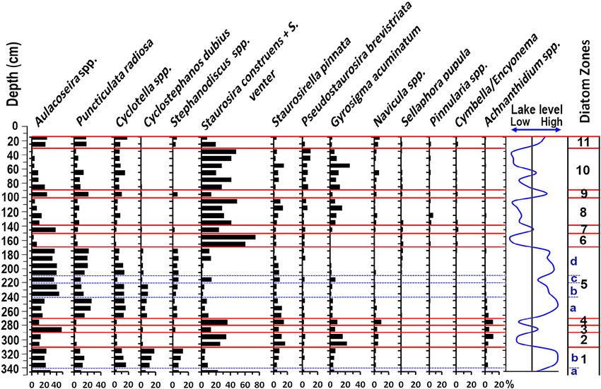
F. Welc et al.: 2400 years of climate change recorded in sediments of Lake Młynek                                                     1185

Table 1. List of radiocarbon determinations.

                          No.    Depth (m)     Lab. reference       14 C BP    Age calibrated      Material dated
                                                                               95 % probability
                          1      0.95–1.00     S/JW 1/2015/A      435 ± 30     1418–1494 CE        Bulk of gyttja
                          2      1.65–1.70     S/JW 1/2015/B     1015 ± 30     971–1048 CE         Bulk of gyttja
                          3      2.40–2.45     S/JW 1/2015/C     1730 ± 30     236–386 CE          Bulk of gyttja
                          4      3.45–3.50     S/JW 1/2015/D     2275 ± 30     401–351 BCE         Bulk of gyttja

Figure 4. Age–depth model of the core M1 from the Lake Młynek sediments. Good runs of a stationary distribution are shown in panel (a);
green curves and grey histograms in panel (b) present distributions for the sediment accumulation rate. Panel (c) shows the calibrated 14 C
dates (transparent blue) and the age–depth model (darker grey areas), which indicate calendar ages. Grey stippled lines show 95 % confidence
intervals and the red curve shows the “best” model based on the weighted mean age for each depth. The model was created by Fabian Welc
using the open Bacon software (Blaauw and Christen, 2011).

nally, the samples were analysed in the Spectro Blue ICP-               MADZU SSM 5000A analyser with a solid sample com-
OES spectrometer at the Regional Research Centre for En-                bustion unit. The method was the catalytically aided com-
vironment, Agricultural and Innovative Technologies, Pope               bustion oxidation at 900 ◦ C with pre-acidification and oven
John II State School of Higher Education, in Biała Podlaska.            temperature 200 ◦ C. A measuring range TC was 0.1 to
A Bernd Kraft Spectro Genesis ICAL solution and VHG                     30 mg carbon. The sample amount was 1 g and aque-
SM68-1-500 Element Multi Standard 1 in 5 % HNO3 were                    ous content < 0.5 g, with repeatability at SD ±1 % of
used.                                                                   the full-scale range (http://www.ssi.shimadzu.com/products/
   Total organic carbon (TOC) analysis was done after                   toc-analyzers/ssm-5000a, last access: 10 June 2021).
sample acidification to remove carbonates in the SHI-

https://doi.org/10.5194/cp-17-1181-2021                                                              Clim. Past, 17, 1181–1198, 2021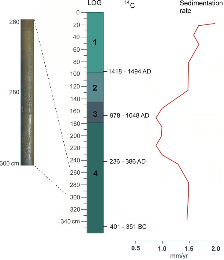
1186                                     F. Welc et al.: 2400 years of climate change recorded in sediments of Lake Młynek

   All selected samples were analysed using a scanning elec-       is varied but due to the organic character of the sediments, its
tron microscope (SEM) HITACHI TM3000 with an energy                values are relatively low, from 0.002 to 0.034 × 10⁻⁷ units
dispersive spectrometer (EDS) SWIFT ED 3000 from Ox-               SI. In grey-brown gyttja with organic matter at 3.50–2.58 m
ford Instruments. The samples were not covered with any            depth, MS rises and drops in turn from 0.01 to 0.02 × 10⁻⁷
conductive material. Magnification range was used 20× to           SI. MS drops from 2.60 m depth, reaching a minimum at
30 000×. This method was used to perform basic micro-              1.63 m. Higher up, MS rises again, with the highest value
scopic observations of samples of the core M1 with point           at 1.35 m; then there is a minimum at 1.05 m, and the next
determination of their chemical composition of major ele-          maximum is at 0.69 m depth (Fig. 6).
ments.
                                                                   4.3   Chronology, lithology and sedimentation rate
4     Results                                                      The age–depth model of the core M1 from Lake Młynek
                                                                   indicates (Fig. 4) that the M1 core chronologically covers
4.1    Bathymetry                                                  the last 2400 years. Bottom deposits of Młynek Lake are
A georadar transect across the lake reflects both its              organic-rich. The core M1 is composed of grey-brown gyt-
bathymetry and composition of its bottom (Figs. 2–3). The          tja at 1.8–3.6 m depth (Fig. 5). At 1.45–1.80 m depth there
superficial layer of the transect is represented by lake ice       is grey-brown gyttja detritus, and at 1.10–1.45 m depth algal
that is ca. 25 cm thick, and although it is almost not visi-       gyttja is recorded. The uppermost part of the core is com-
ble on radar images due to its thickness being smaller than a      posed of grey-brown (depth 0.4–1.1 m) and detritus gyttja
vertical resolution of measurements, beneath there are mul-        (0.0–0.4 m). The sedimentation rate was calculated based on
tiple abundant horizontal reflections of energy from the bot-      the age–depth model. Results reflect quite a stable sedimen-
tom of the ice. Two narrow and vertical zones with small           tary environment with a general rate of 1.5 mm yr−1 . The rate
diffraction hyperboles at 23 and 29 m of the transect indi-        is stable at 3.40–1.77 m depth and equal to ca. 1.5 mm yr−1 .
cate upward deformation of bottom sediments at the location        It drops to 1 mm and then rises to 1.3–1.8 mm yr−1 at 1.77–
sites of the sounding core and the core M1 (Fig. 2a). The          0.30 m. At 0.0–0.3 m the sedimentary rate is the highest and
top of the underlying mineral deposits (so-called hard bot-        equal to ca. 3 mm yr−1 (Fig. 5).
tom) is indicated as a distinct downward-deflected reflection
surface (Fig. 2b). In the central part of the lake, it occurs      4.4   Pollen
at 2.6 m depth (two-way travel time 290 ns) and indicates
                                                                   Based on percentage contents of main trees and terrestrial
the top of the Holocene organic sediments. Unfortunately,
                                                                   herbs five local pollen assemblage zones (LPAZ M1-M5)
beneath there is a signal-absorption zone (Fig. 2d), result-
                                                                   were established in the pollen sequence of the Lake Młynek.
ing from the fact that most sediments are composed of fine-
                                                                   The pollen contents were determined based on changes in the
grained organic material (gyttja). However, the thickness of
                                                                   percentage of individual taxa, confirmed by a cluster analysis
this layer was determined by drillings to about 5 m. A relief
                                                                   (Table 2, Fig. 9).
of the lake bottom in the GPR image reflects a cross section
of a buried glacial tunnel valley that was eroded mainly in
sandy and sandy-gravel deposits. Close to the lake shore (0        4.5   Diatoms
to 20 m in the north-west and 110 to 140 m in the south-east),     Studies of the Lake Młynek bottom sediments revealed the
there are numerous oblique and chaotically parallel reflection     presence of more than 200 diatom taxa belonging to 54 gen-
surfaces dipping towards the channel axis. They reflect bed-       era (Zalat et al., 2018) (Fig. 8). Diatoms were generally abun-
ding of the Pleistocene sandy-gravel series that partly filled a   dant and well to moderately preserved in most samples, al-
subglacial channel (Fig. 2c).                                      though with a mixture of mechanically broken valves, es-
                                                                   pecially in the topmost part of the core. The results of the
4.2    Magnetic susceptibility                                     diatom analysis and relative abundance of the most domi-
                                                                   nant taxa enabled subdivision of the M1 core section into 11
MS is highly dependent on lithology and grain size of de-          diatom assemblage zones (Fig. 8) that reflected six phases
posits (Dearing, 1994; Sandgren and Snowball, 2001). It re-        of lake development (Zalat et al., 2018). Moreover, changes
flects the presence and size of ferromagnetic particles in a       in chrysophyte cysts distributions along with variation in di-
sample (Verosub and Roberts, 1995). Increased content of           atom composition could be related to changes in pH, climate
ferromagnetic minerals such as magnetite, Fe-Ti oxides or          and trophic status. Stomatocysts can be used as the index of
pyrrhotite generates higher MS whereas biotite, pyrite, car-       lake-level changes, habitat availability, metal concentrations
bonates and organics result in its lower values. The total vol-    and salinity.
ume of magnetic minerals in lake sediments mostly reflects
climatic changes in a catchment (Bloemdal and deMenocal,
1989; Snowball, 1993; Peck et al., 1994). MS in the core M1

Clim. Past, 17, 1181–1198, 2021                                                       https://doi.org/10.5194/cp-17-1181-2021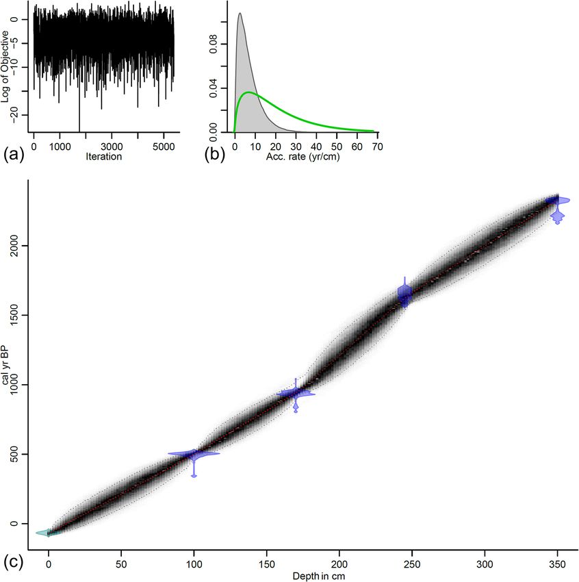
F. Welc et al.: 2400 years of climate change recorded in sediments of Lake Młynek                                                  1187

Table 2. Local pollen assemblage zones of the Lake Młynek.

           Zone         Depth (m)      Main features of pollen spectra
           LPAZ M1      345–315 cm     Pollen grains of Carpinus reached 33.5 % and Alnus 25 %, Pinus and Betula are < 20 %.
                                       A top border of this zone is indicated by decline of Carpinus.
           LPAZ M2      315–265 cm     The share of Carpinus drops significantly (< 10 %), contents of Betula, Quercus and
                                       Corylus are slightly raised. The percentages of Gramineae significantly increased up to
                                       7.5 %. There are continuous curves of Cannabis/Humulus, Chenopodiaceae, Plantago
                                       lanceolate, Rumex acetosella and Secale cereale, and a top boundary is indicated by a
                                       decline of Gramineae.
           LPAZ M3      195–265 cm     At the beginning the curve of Betula rises to 24 % but then drops < 10 %. The
                                       share of Carpinus and Fagus rises to 19 % and 27 %, respectively. Gramineae con-
                                       tent decreased by < 2 %, and the curves of Secale cereale, Plantago lanceolate and
                                       Rumex acetosella disappear. There are only single pollen grains of Chenopodiaceae and
                                       Cannabis/Humulus. A top boundary is indicated by a rise in Gramineae.
           LPAZ M4      195–145 cm     Content of Fagus pollen begins to gradually decrease. The share of pollen grains of
                                       Betula increases and becomes stable at 22 %–27 %. Content of the Gramineae pollen
                                       grains increases again to 7 %. Curves of Cannabis/Humulus, Plantago lanceolate,
                                       Rumex acetosella and Secale raise, and a top boundary is marked by a rapid rise in
                                       Cannabis/Humulus.
           LPAZ M5      145–15 cm      Curves of main deciduous trees decline: Carpinus < 9 %, Fagus < 5 %, Quercus < 5 %,
                                       Alnus < 15 %, Betula < 14 %. Pinus content increases to 40 %. There is a significant
                                       rise in Gramineae up to 15 %. Percentages of Cannabis/Humulus reach absolute max-
                                       ima (25 %), but close to middle part of this zone their strong decline is observed (be-
                                       low 2 %–3 %). The continuous curves of Cerealia undiff., Centaurea cyanus, Plantago
                                       lanceolate, Rumex acetosella andRumex acetosella appeared, and single pollen grains
                                       of Polygonum dumetorum, Polygonum aviculare and Urtica were present.

4.6    Geochemistry                                                      Oldfield, 1986). In Lake Młynek there is an apparent neg-
                                                                         ative relationship between TOC and MS. Several intervals
Various factors influence distribution and accumulation of               show both higher percentages of TOC and lower MS values.
geochemical elements in lake sediments. Most important                   Changes in MS in Lake Młynek sediments most probably
are texture, mineral composition, oxidation/reduction state,             record an input of clay into the lake and diagenetic conditions
absorption/desorption and physical transportation processes              in bottom sediments. Iron oxides are presumably of detrital
(Ma et al., 2016). Curves of representative elements are gen-            origin and were delivered to the basin through deep valleys
erally used to characterize sedimentary environments. Most               incised at the north-western shore. Concentration of ferro-
analysed elements do not indicate any clear trend with depth             magnetic minerals is connected with periodical intensive soil
in Lake Młynek. The curves of S and TOC show significant                 erosion around the lake. Their higher content also depends
increases at 2.0–1.4 m depth that are slightly correlated with           on diagenetic processes in bottom sediments. Oxidation of
decreased Al, Fe, K, Ca, Mg and MS (Fig. 6). Sulfur content              organic matter in anoxic conditions (by iron-oxide-reducing
is correlated with the existence of iron sulfides. In the studied        bacteria) results usually in an increase in ferromagnetic parti-
core, Fe is positively correlated with Al and Ti (Fig. 7). Fe–           cles (small particles are removed first). Conversely, oxygena-
Ti oxides are noted in SEM (scanning electron microscopy)                tion by heavy floods stops this process, and small magnetic
EDS (energy dispersive spectroscopy) analysis. They are re-              particles are preserved (Jelinowska et al., 1997). At 1.40 m
sistant to surface weathering and carry trace elements (Bauer            depth, TOC suddenly drops, probably due to deforestation,
and Velde, 2014). At ca. 3 m, high-frequency peaks of Al, K,             and then MS rises significantly due to the increasing input
Ca, Na, Mg, Fe and S occur (Fig. 6).                                     of terrestrial (non-organic) material to the lake. Such a coin-
                                                                         cidence clearly indicates that TOC is both of autochthonous
5     Discussion                                                         and allochthonous derivation (Fig. 6).
                                                                            The highest contents of detrital elements like Al, K, Ca
Magnetic susceptibility is generally low in biogenic sedi-               and Mg are to be associated with sudden delivery of clastic
ments such as gyttja, which is composed mainly of microfos-              material to the lake, e.g. during increased flooding or rainfall
sil skeletons, e.g. diatoms and radiolarians (Thompson and               (Wirth et al., 2013). Aluminium is extremely immobile, that

https://doi.org/10.5194/cp-17-1181-2021                                                             Clim. Past, 17, 1181–1198, 2021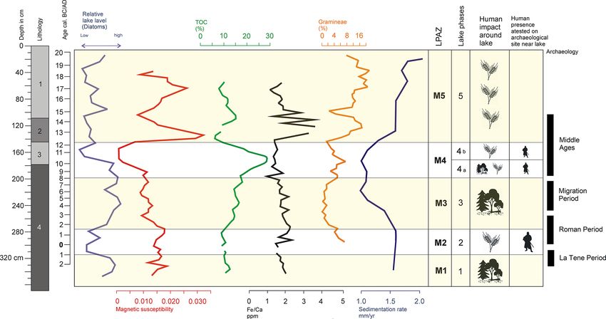
1188                                         F. Welc et al.: 2400 years of climate change recorded in sediments of Lake Młynek

                                                                         0.41) which are lower than the critical value of 2 as indicated
                                                                         by Myers and Wignall (1987). The ratio of total Fe to total P
                                                                         ranges from 13.91 (1.6 m depth) to 30.82 (0.55 m). The val-
                                                                         ues are typical for other lakes in northern Poland, which vary
                                                                         from 3 to 180 according to Bojakowska (2016). The release
                                                                         of P follows in reducing conditions. According to Ahlgren
                                                                         et al. (2011) it can be up to 10 times greater than in aerobic
                                                                         conditions. However, there is a poor correlation with other re-
                                                                         dox proxies, i.e. Th / U (R = 0.08), which may be caused by
                                                                         the presence of Al which forms Al(OH)3 . In such systems,
                                                                         even though the redox state favours the release of P from
                                                                         iron minerals, the P is immobilized by binding with hydrox-
                                                                         ides. Thus, the presence of Al(OH)3 can stop the release of
                                                                         P even in an anoxic hypolimnion (Hupfer and Lewandowski,
                                                                         2008). This could be the case in the studied sediments as Al
                                                                         shows positive correlation with P content (R = 0.49). Except
                                                                         for Fe / Ca, all counted ratios point to anoxic conditions in
                                                                         all studied samples, which is typical in eutrophic lakes. Nev-
                                                                         ertheless, as all proxies are characterized by extreme values
                                                                         at the 3.05 m depth, they seem to depend on an external load
                                                                         of terrigenous material. It is confirmed with very good posi-
                                                                         tive correlation between Fe and Al (0.95), Fe and Ti (0.64),
                                                                         Mn and Al (0.46), or Mn and Ti (0.78).
                                                                            The periphytic diatom species dominate throughout the
Figure 5. Lithology of the M1 borehole with radiocarbon deter-
                                                                         core. A high proportion of periphyton to plankton assem-
minations with 95 % confidence, close up – photo of the log at 2.6–      blages was reported as indicative of long-lasting ice cover
3.0 m depth and sedimentary rate (mm yr−1 ) estimated based on the       (Karst-Riddoch et al., 2005), whereas a shift from benthic
age–depth model. Description of LOG: 1 – hydrated, detritus-type         to planktonic diatom taxa is considered an ecological indi-
gyttja; 2 – very plastic, algal gyttja; 3 – grey-brown peaty, detritus   cator, which is interpreted in high-altitude lakes as a record
gyttja; 4 – grey-brown gyttja (photo and drawing: Fabian Welc).          of shorter winters and increased temperatures. The common
                                                                         occurrence of benthic forms represented by a Staurosira ven-
                                                                         ter/Staurosirella pinnata diatom assemblage indicates cir-
is why it should be regarded as a typical lithogenic element             cumneutral to slightly alkaline shallow water with lowering
(Price et al., 2007). Additionally, Al is a major constituent of         lake levels and prolonged ice cover. However, Aulacoseira is
soils and other sediments as a structural element of clays. It           the most dominant planktonic genus followed by Cyclotella
has a strong positive correlation with many major elements               and low frequency of Cyclostephanos. Diatom preservation
(Fig. 7). The association between Al and other elements can              in the upper part of the core (depth 1.40–0.15 m) is moderate
be therefore used as the basis to compare natural elemental              to relatively poor, and the recognized assemblage was repre-
contents in sediments and soils. Calcium is well correlated              sented by the occurrence of some dissolved and teratological
with Al and likely originated from terrigenous bicarbonate               diatoms valves, in particular the topmost part of the core sec-
inputs and deposited in a lake as a solid carbonate (Miko                tion (0.30–0.15 m) (Zalat et al., 2018).
et al., 2003). Calcium is evidently more easily removed in
solution from a mineral material and it is highly concentrated           6     Phases of the Lake Młynek development
in highly erosional periods (Mackereth, 1965).
   The Fe / Ca ratio is considered as a eutrophication proxy.            Based mostly on the results of palynological studies, five
The highest values are found in low-oxygenation, eutrophic               main phases of the Lake Młynek development in relation to
or dystrophic reservoirs (i.e. Kraska and Piotrowicz, 2000;              the climate and human-induced environmental change were
Holmes and De Decker, 2012), whereas the low Fe / Ca ratio               distinguished (Fig. 10).
in bottom sediments indicates the oligotrophic character of a
lake. In the studied core sediments, Fe / Ca ratio varies from
                                                                         6.1    Phase 1: 2300–2100 cal BP (ca. 4–1 BCE), depth:
0.80 (depth 3.05 m) to 3.67 (1.2 m). The ratio is low, indicat-
                                                                                3.45–3.15 m
ing oligotrophic conditions in bottom sediments, which gives
conflicting results with other data. The Fe / Ca ratio can be            This phase is recorded in LPAZ M1, which represents closed
disturbed by detrital input to the lake (Fig. 6). The dysaerobic         forest communities dominated by hornbeam and alder, which
conditions in the lake are confirmed by Th / U ratios (0.03–             colonized marshlands near lake shores. Plants of open stands

Clim. Past, 17, 1181–1198, 2021                                                            https://doi.org/10.5194/cp-17-1181-2021
F. Welc et al.: 2400 years of climate change recorded in sediments of Lake Młynek 1189 Figure 6. Concentration depth curves for selected elements and TOC in the core M1 of Lake Młynek sediments. Description of LOG: 1 – hydrated, detritus-type gyttja; 2 – very plastic, algal gyttja; 3 – grey-brown peaty, detritus gyttja; 4 – grey-brown gyttja (drawing: Fabian Welc). are only rarely noted as well as indicators of anthropogenic a shallow and slightly alkaline lake. This interval was fol- activity (e.g. Plantago lanceolata). Vegetation at that time lowed by a great abundance of the planktonic Alkaliphilus was relatively natural and not disturbed. The diatom as- diatoms of subzone DZ 1b (3.35–3.15 m, Fig. 8) dominated semblage at the start of this record (3.45–3.40 m depth) by Aulacoseira granulata, Cyclotella sensu lato species, Cy- was distinguished by diatom subzone DZ1a (Fig. 8) domi- clostephanos dubius and Stephanodiscus species. The diatom nated by the periphytic taxa such as Staurosira construens, assemblage suggests a rising lake level with increasing nutri- Staurosira venter, Staurosirella pinnata, Gyrosigma acumi- ents (Douglas and Smol, 1999; Zalat, 2015). The predom- natum associated with the planktonic Aulacoseira granu- inance of A. granulata suggests a high trophic status and lata, A. ambigua and Puncticulata radiosa, which indicates slightly alkaline freshwater environment with high silica con- https://doi.org/10.5194/cp-17-1181-2021 Clim. Past, 17, 1181–1198, 2021
1190                                    F. Welc et al.: 2400 years of climate change recorded in sediments of Lake Młynek

Figure 7. Scatter plot showing the correlation in the core M1 between S and TOC, Al and TOC, Ti and Fe, and Ti and Fe (drawing:
Anna Rogóż-Matyszczak).

centration (Kilham et al., 1986; Zalat et al., 2018). Magnetic    Ralska-Jasiewiczowa et al., 1998). Pollen data indicate that
susceptibility is high and corresponds to high contents of Fe,    societies of that time cultivated rye and probably hemp. It
Ti and Al, indicating an increasing influx of terrigenous ma-     is the oldest settlement phase at Janiki Wielkie stronghold
terial, presumably activated by intensive rainfall.               and corresponds to the termination of the La Tène and the
                                                                  time of the early Roman period. Human communities in the
                                                                  vicinity of the lake can be connected with settlements of the
6.2    Phase 2: 2100–1830 cal BP (ca. 1 BCE–2 CE),                eastern Baltic Kurgan culture (Rabiega et al., 2017). Dur-
       depth: 3.15–2.65 m                                         ing this phase, planktonic diatoms were replaced by ben-
                                                                  thic taxa, (DZ2) such as Staurosira construens, S. venter
During this phase changes in the environment around the
                                                                  and Staurosirella pinnata accompanied by a significant abun-
lake were caused by significant human impact. This phase
                                                                  dance of Gyrosigma acuminatum indicating a lower lake
corresponds with the LPAZ M2, characterized by the reduc-
                                                                  level and dominance of a mesotrophic alkaline freshwater en-
tion and fragmentation of the hornbeam-dominated forest.
                                                                  vironment. The lower stands were interrupted by a short rise
Birch, pine and hazel expanded under better lighting con-
                                                                  in water level at 2.90–2.85 m (ca. 1930–1896 cal BP) where
ditions in a partly open forest. Mid-forest pastures occu-
                                                                  the abundance of planktonic eutrophic indicator Aulacoseira
pied rather small-scale open areas, as can be inferred from
                                                                  spp. increased suddenly at the expense of the benthic taxa.
higher percentages of Plantago lanceolata and other herba-
                                                                  During this phase climatic conditions were still similar to
ceous plants, e.g. Gramineae, Artemisia and Rumex ace-
                                                                  ones in the previous phase, but it was drier than is reflected
tosa/acetosella. Cultivated plants such as Cannabis and Se-
                                                                  by shallowing of the lake. This phase can be correlated with
cale are rare; however, their occurrence is entirely consis-
                                                                  the so-called Roman Climatic Optimum (see McCormick et
tent with other human indicators present during this phase.
                                                                  al., 2012).
This phase is commonly noted and similarly expressed in nu-
merous palynological sequences in neighbouring areas (see
for example Noryśkiewicz, 1982, 1987; Bińka et al., 1991;

Clim. Past, 17, 1181–1198, 2021                                                     https://doi.org/10.5194/cp-17-1181-2021
F. Welc et al.: 2400 years of climate change recorded in sediments of Lake Młynek 1191
Figure 8. Diatom stratigraphy of the core M1, showing diatom zones and lake phases and relative water level changes estimated based on
the relation between planktonic and benthonic diatom taxa (interpretation and drawing: Abdelfattah Zalat).
Figure 9. Percentage pollen diagram from core M1 – selected taxa.
6.3 Phase 3: 1830–1150 cal BP (ca. 2–9 CE), depth: 2017). Reduction of human impact and human-generated
2.65–1.95 m semi-open habitats allowed for a short-term expansion of
birch into empty, open areas, which were later replaced by
This phase corresponds to LPAZ M3 when a forest restora- hornbeam that rebuilt its position to the level it was at in
tion occurred. Absence of human indicator plants suggest the LPAZ M1. Elm also expanded again in a riparian for-
that the settlement in the catchment was abandoned. There est. This restoration of the natural forest was followed by
are also no traces of human activity nearby (Rabiega et al., abrupt expansion of beech in the second half of the LPAZ
https://doi.org/10.5194/cp-17-1181-2021 Clim. Past, 17, 1181–1198, 20211192 F. Welc et al.: 2400 years of climate change recorded in sediments of Lake Młynek
Figure 10. Diagram with selected palaeoenvironmental proxies including lithology (1 – hydrated, detritus type gyttja; 2 – very plastic,
algal gyttja; 3 – grey-brown peaty, detritus gyttja; 4 – grey-brown gyttja) with phases of human activity in the vicinity of Lake Młynek,
supplemented by an archaeological chronology for Poland (drawing: Fabian Welc).
M3. The area of open herbaceous plants communities, previ- 6.4 Phase 4: 1150–780 cal BP (ca. 9–13 CE), depth:
ously widespread, was limited. 1.95–1.45 m
Abundant planktonic diatoms including Aulacoseira spp.
and Puncticulata radiosa and the common occurrence of
This phase is correlated with the LPAZ M4 and is divided
small Cyclotella spp. occurred in the lake (Fig. 8), which
into two sub-phases 4a and 4b (Fig. 10). The sub-phase 4a
indicates its deepening, enhanced thermal stratification, re-
marks the onset of another settlement phase, resulting in for-
duced mixing and increased thermal stability (Zalat et al.,
est clearing. Disturbances took place firstly in a beech forest
2018). Intensified development of vegetation cover and
and less in a hornbeam-dominated one. The anthropogenic
higher lake levels are indicated by geochemical indices. A
activity is reflected by presence of Gramineae, Artemisia,
gradual drop of MS corresponds with decreased content of
Cannabis/Humulus, Plantago lanceolata, Rumex acetosella,
detrital elements such us Fe, Ti, Al and K, accompanied by
Secale and Cerealia undiff. Diatom assemblages suggest a
a gradual increase in TOC and the Fe / Ca ratio. Lower MS
deepening of the lake (Zalat et al., 2018) as indicated by the
and Al content (acting as a major constituent of soils) accom-
abundance of Aulacoseira associated with Puncticulata ra-
panied by the higher TOC suggest limited erosion, in spite
diosa in the upper part of the diatom zone 5 at 1.85–1.70 m
of gradually higher precipitation in the lake catchment and
depth (ca. 1070–941 cal BP). The diatom assemblage sug-
therefore a rise in its water level (Fig. 6). The climate in this
gests a rising lake level, higher trophy and stronger turbu-
phase has become more humid. Increased rainfall and de-
lent mixing conditions (Rühland et al., 2008; Zalat et al.,
creased evaporation are reflected in lake sedimentation as the
2018). Moreover, the greatest reduction of abundant Frag-
lake got deeper, resulting in reduced deposition and greater
ilaria sensu lato accompanied by abundant A. granulata,
stability. This phase could be associated with a global cool-
could be a result of forest clearing around the lake. Higher
ing of the Bond 1 event (1.5 ka BP) (Bond et al., 1997; Welc,
TOC corresponds with lower content of detrital material (Fe,
2019).
Ti, Al and K) and lower MS, and it can reflect a progressing
humidity (Fig. 6). This phase can be correlated with the Mi-
gration Period and the early Middle Ages. A wooden-loamy
defence rampart was raised at the end of the phase in a set-
tlement close to the lake (archaeological phase III), after re-
moval of a natural soil developed during abandonment of the
Clim. Past, 17, 1181–1198, 2021 https://doi.org/10.5194/cp-17-1181-2021F. Welc et al.: 2400 years of climate change recorded in sediments of Lake Młynek 1193
site in the early Roman Period. After a short period, this ter environment (see, Bińka et al., 2020). As previously men-
stronghold was destroyed. Charcoal from a fired wall that tioned, in the 15th century CE a mill was built near the lake,
represents destruction at the end of the archaeological phase and damming of the water in the mill reservoir probably con-
IIIA was dated at 1245 ± 25 cal BP (i.e. 682–870 CE; 95.4 % tributed to periodical blooms of dinoflagellate populations in
probability) and 1090 ± 30 cal BP (i.e. 892–1014 CE; 95.4 % Lake Młynek. Major blooms of Tetraedron, which usually
probability) (Rabiega et al., 2017). precede blooms of the dinoflagellate, were most probably the
Human impact declines during the subphase 4b (1.70– main factor that contributed to the decline of settlement at the
1.45 m depth, ca. 940–782 cal BP). At this time birch and stronghold (Bińka et al., 2020). This zone is also character-
less intensively poplar occupied temporarily abandoned open ized by increased precipitation which is reflected by more
areas, especially toward the end of the zone, when human intensive terrestrial inflow to the lake and is confirmed by
activity was less intensive. Alder became more abundant, quasi-linear correlation of MS with contents of Fe and Ti in
probably expanding into exposed marginal areas of the lake. sediments (Fig. 6). The modern lake is shallow (2–3 m) and
The sub-phase 4b corresponds to the diatom zone 6 (Fig. 8), gradually overgrowing. Summing up, the phase 5 is marked
which is characterized by abundant benthic Fragilaria sensu by intensive human activity around the lake, and therefore
lato with sporadic occurrence of planktonic taxa. A high pro- most “natural” environmental and climate changes are oblit-
portion of benthic to plankton assemblages was reported as erated.
indicative of long-lasting ice cover (Karst-Riddoch et al.,
2005). As well as this, a great abundance of the benthic
Staurosira venter and Staurosira construens with marked 7 Development of Lake Młynek – a regional
decline in the planktonic diatoms such as Aulacoseira spp. background
and Puncticulata radiosa reflects lowering water levels and
slightly alkaline freshwater, lower nutrient concentrations The above scenario seems to be confirmed by earlier
and low silica content (Kilham et al., 1986; Stevens et al., palaeoenvironmental research carried out in the south-
2006; Zalat et al., 2018). western part of the Warmia–Masuria lake lands (Kupry-
In the stronghold at the lake shore, the next phase of hu- janowicz, 2008; Kołaczek et al., 2013). Previous studies of
man activity took place at the end of the 11th century CE the lake sediments in this region were based mainly on pollen
when a new rampart was raised. Wooden constructions were analysis and enable the comparison of the Lake Młynek
also built, traces of which were excavated in the gate passage. record with other sequences.
The settlement was finally abandoned, presumably in the first The closest records from Lake Woryty (Pawlikowski et
half of the 13th century, and then its ramparts were strongly al., 1982; Noryśkiewicz and Ralska-Jasiewiczowa, 1989;
eroded, with their material moving towards a yard and the Ralska-Jasiewiczowa and Latałowa, 1996), just 35 km to the
moat (Rabiega et al., 2017). The sub-phase 4b is character- east, is a reference one. Palaeoenvironmental records inferred
ized by a gradual warming, which correlates with a gradual from the Lake Młynek core are very similar to the Woryty pa-
shallowing of the lake and increased rate of sedimentation. lynological succession with distinctive human impact during
Human impact on the environment in this sub-phase is al- the Roman Period and the Medieval Ages, however, a de-
ready so great that reconstruction of a climate change is not tailed comparison is difficult, because of the low resolution
clear. There is no doubt; however, that this is a warm period, of the pollen spectrum obtained at Woryty.
which should be correlated with the Medieval Warm Period The second site is Lake Drużno, located in the Vistula
(MWP) (Mann et al., 2009). Delta, 35 km to the north of Młynek Lake (Zachowicz et al.,
1982; Zachowicz and K˛epińska, 1987; Miotk-Szpiganowicz
6.5 Phase 5: 780–0 cal BP (13 CE–present time), depth:
et al., 2008). Unfortunately, the low resolution and the lack
1.45–0 m
of reliable age–depth models of the lake make comparison
difficult. Despite habitat differences between Lake Drużno
This phase starts about 1200 CE and is connected with the and Lake Młynek, pollen records obtained at both sites are
early Modern Period. Cultivation and treatment of hemp has very similar and comprise human indicators during the Ro-
been terminated but cultivation of cereals and presence of man Period and human impact during the Medieval times.
synanthropic plants indicate human activity near the lake. The pollen spectrum from Lake Łańskie (Madeja, 2013),
The water level changes only slightly and is not high, which located 55 km to the south-east from Lake Młynek, shows
is evidenced by a great abundance of benthic diatom taxa higher pine content and lower share of beech than in the
over the planktonic forms (DZ 8–10, Fig. 8). There is a drop case of Lake Młynek. Such divergences are probably not
in TOC and rise in MS caused by increasing input of terres- only due to different location and environmental conditions
trial material at 1.4 m depth (ca. 751 cal BP), resulting pre- in the lake vicinity but also depend on different size of these
sumably from human deforestation. The small watercourse lakes. Lake Młynek is a very small (0.7 km2 ) mid-forest
which enters the lake from the north-east appeared most basin, whereas Lake Łańskie is over 10 km2 large and con-
probably during this phase and had a strong impact on its wa- tains mostly a regional pollen record. Based on periodical ap-
https://doi.org/10.5194/cp-17-1181-2021 Clim. Past, 17, 1181–1198, 20211194 F. Welc et al.: 2400 years of climate change recorded in sediments of Lake Młynek
pearances of human plant indicators and archaeological data 8 Conclusions
between 300 BCE and 800 CE, three human phases of the
West Baltic Barrow, Wielbark and Prussian cultures were dis- Based on the results of laboratory analysis, supplemented
tinguished (Madeja, 2013). In the pollen diagram from Lake with archaeological data, five main environmental phases of
Młynek (phase 2), the first culture is indicated, including ter- the Lake Młynek development were distinguished (Fig. 10).
mination of the La Tène and the Roman Period. Significant Radiocarbon ages enabled detailed chronology, whereas
growth of human indicators from the beginning of the 11th pollen data and stratigraphy of the stronghold to the north-
century CE, are visible in diagrams from both sites. A more east of the lake made correlation possible between human
local record from Lake Młynek is especially marked by high activity for the last 2300 years and environmental data. From
Humulus/Cannabis content (to 25 %) in the 13th–15th cen- the first century BCE to second century CE the forest around
turies CE. In the sediments of Lake Łańskie, hemp occurred the lake was much reduced, which can be associated with
discontinuously and was < 1 %. pre-Roman and Roman occupation phases (confirmed also
The pollen records from Lake Młynek are similar to the by the stronghold located close to the lake). From the second
ones from the Masurian lakes, Wojnowo, Miłkowskie and to ninth century CE there is a gradual restoration of the forest
J˛edzelek, located over 100 km to the east (Wacnik et al., and decline in human activity along with a deepening of the
2014). Recorded episodes of human impact on vegetation lake as a result of wetter climatic conditions. This colder and
during the Roman Period and Medieval times are separated humid phase corresponded to the Bond 1 event (1.5 ka BP)
by 500–600-year-long intervals without cultivation and with cooling episode. Intensive forest clearing around the lake
natural reforestation (indicated by a strong presence of birch, occurred in the 9th–13th centuries CE as result of another
which is a pioneer species). A similar period of human with- phase of human activity. This period is marked by warming,
drawal in the Lake Młynek section began and terminated ear- confirmed by a gradual shallowing of the lake (Middle Age
lier than recorded in the lakes Wojnowo and Miłkowskie. Warm Period). Since the 14th century CE strong human im-
Another history of human activity is represented in a record pact transformed the local landscape, especially through the
from Lake Sal˛et (Szal et al., 2014b). Pollen grains of cul- construction and activity associated with the mill and the cre-
tivated and ruderal plants are noted continuously from the ation of a small artificial lake in the 15th century CE. This
early Iron Age to the early Medieval times. In contrast to the results in potential climate-driven environmental changes be-
pollen record from lakes Młynek, Wojnowo and Miłkowskie, ing obscured by the direct impact of humans on the lake and
the suggested continuous settlement in the neighbourhood its catchment. It is important to add here that transformations
of the Lake Sal˛et was interrupted by a single very short of Lake Młynek, reconstructed based on diatom analysis, not
decline of human impact between 880–980 CE (Szal et al., only indicate changes of the lake water level and correspond
2014a). Numerous pollen data are available from the area with a human impact but also determine episodes of more
adjacent in the south-west in the Brodnica Lake District, in- humid climate during coolings.
cluding Strażym Lake (Noryśkiewicz, 1987; Noryśkiewicz We can conclude that environmental transformations
and Ralska-Jasiewiczowa, 1989), Oleczno Lake (Filbrandt- recorded in bottom lake sediments of Lake Młynek were
Czaja, 1999; Filbrandt-Czaja et al., 2003) and the Chełmno highly dependent on human activity and were especially
Lakeland (Noryśkiewicz, 2013). Pollen records from this re- intensive in the Roman and Middle Age periods due to
gion also suggest intensive settlements during La Tène, Ro- favourable climatic conditions
man and Medieval periods.
Pollen records from other sites located to the east of Lake
Młynek indicate differences in the representation of beech Data availability. All data will be made available on request.
content. The Fagus sylvatica content changes to the north-
east, and its significantly high content in Lake Młynek sedi-
ments represents a very local record in a small lake. The de- Author contributions. FW, JN, and LM conceptualized the
study. FW, JN, KB, ARM, MO, and AZ designed the methodol-
cline of Fagus sylvatica depends on a continental climate and
ogy. Formal analysis was performed by FW, JN, LM, KB, ARM,
is noted in pollen diagrams from the lakes Sal˛et (Szal et al.,
MO, and AZ. The investigation was carried out by FW and JN. FW
2014a), Mikołajki (Ralska-Jasiewiczowa, 1989), Żabińskie and JN provided resources and wrote the original draft. FW, JN, and
(Wacnik et al., 2016) and Wigry (Kupryjanowicz, 2007). A LM reviewed and edited the paper. Visualization was carried out by
decline of beech is accompanied by a rise in Picea abies. FW, KB, ARM, MO, and AZ. JN and FW acquired the funds.
A record of human activity in pollen spectra from eastern
Poland was noted at many sites.
Competing interests. The authors declare that they have no con-
flict of interest.
Clim. Past, 17, 1181–1198, 2021 https://doi.org/10.5194/cp-17-1181-2021F. Welc et al.: 2400 years of climate change recorded in sediments of Lake Młynek 1195
Acknowledgements. The research was funded by the Brauer, A., Dulski, P., Mangili, C., Mingram, J., and Liu, J.: The
National Science Centre in Poland in the project UMO- potential of varves in high-resolution palaeolimnological studies,
2016/21/B/ST10/03059: “Correlation of prehistoric and early PAGES News, 17, 96–98, 2009.
medieval settlement phases in north-east Poland with the changes Cooke, G. D., Welch, E. B., Peterson, S., and Nichols, S. A.:
of the natural environment in the light of lacustrine sediments Restoration and Management of Lakes and Reservoirs, CRC
study”. Press, Boca Raton, USA, 2005.
Czymzik, M., Dulski, P., Plessen, B., von Grafenstein, U., Nau-
mann, R., and Brauer, A.: A 450-year record of spring-summer
Financial support. This research has been supported by the Na- flood layers in annually laminated sediments from Lake Am-
tional Science Centre in Poland – Narodowe Centrum Nauki (grant mersee (southern Germany), Water Resour. Res., 46, W11528,
no. UMO-2016/21/B/ST10/03059). https://doi.org/10.1029/2009WR008360, 2010.
Dearing, J. A.: Environmental magnetic susceptibility: using the
Bartington MS2, Chi Publishing, Keniloworth, UK, 1994.
Review statement. This paper was edited by Keely Mills and re- Douglas, M. S. V. and Smol, J. P.: Freshwater diatoms as indicators
viewed by Daniel Schillereff and one anonymous referee. of environmental change in the High Arctic, in: The Diatoms:
Applications for the Environmental and Earth Sciences, edited
by: Stoermer, E. F. and Smol, J. P., Cambridge University Press,
Cambridge, UK, 227–244, 1999.
Duff, K. E., Zeeb, B. A., and Smol, J. P.: Atlas of Chrysophycean
Cysts, 2. Kluwer Academic Publishers, Dordecht, the Nether-
References lands, Boston, Massachusetts, USA, London, UK, 1995.
Duff, K. E., Zeeb, B. A., and Smol, J. P.: Chrysophyte cyst biogeo-
Ahlgren, J., Reitzel, K., De Brabandere, H., Gogoll, A., and Rydin, graphical and ecological distributions: a synthesis, J. Biogeogr.,
E.: Release of organic P forms from lake sediments, Water Res., 24, 791–812, 1997.
45, 565–572, 2011. Elbert, J., Grosjean, M., von Gunten, L., Urrutia, R., Fischer, D.,
Bauer, A. and Velde, B.: Geochemistry at the Earth’s Surface Move- Wartenburger, R., Ariztegui, D., Fujak, M., and Hamann, Y.:
ment of Chemical Elements, Springer-Verlag, Berlin, Heidel- Quantitative high-resolution winter (JJA) precipitation recon-
berg, Germany, 2014. struction from varved sediments of Lago Plomo 47◦ S, Patago-
Bińka, K., Cieśla, A., Łacka,
˛ B., Madeyska, T., Marciniak, B., Sze- nian Andes, AD 1530–2001, Holocene, 22, 465–474, 2012.
roczyńska, K., and Wi˛eckowski, K.: The development of Bł˛e- Filbrandt-Czaja, A.: Zmiany szaty roślinnej okolic jeziora Oleczno
dowo Lake (Central Poland) – A palaeoecological study, Stud. w późnym holocenie pod wpływem czynników natural-
Geol. Polon., 100, 1–83, 1991. nych i antropogenicznych, in: Studia nad osadnictwem śred-
Bińka, K., Welc, F., Nitychoruk, J., Sieradz, D., and Lewczuk, A: niowiecznym ziemi chełmińskiej 3, edited by: Chudziak, W.,
Unique finds in palynological spectra: acetolyze resistant vegeta- Uniwersytet Mikołaja Kopernika (UMK), Toruń, Poland, 61–68,
tive forms of freshwater dinofagellate based on the Lake Młynek 1999.
record from northeastern Poland, Studia Quaternaria, 37, 59–67, Filbrandt-Czaja, A., Noryśkiewicz, B., and Piernik, A.: Intensifi-
2020. cation gradient of settlement processes in pollen diagrams from
Blaauw, M. and Christen, J. A.: Flexible Palaeoclimate Age-Depth Dobrzyńsko-Olsztyńskie Lake District, Ecological Questions, 3,
Models Using an Autoregressive Gamma Process, Bayesian 125–137, 2003.
Anal., 6, 457–474, 2011. Francus, P., von Suchodoletz, H., Dietze, M., Donner, R. V.,
Blaauw, M., Christen, J. A., Mauquoy, D., van der Plicht, J., and Bouchard, F., Roy, A.-J., Fagot, M., Verschuren, D., and
Bennett, K. D.: Testing the timing of radiocarbon dated events Kröopelin, S.: Varved sediments of Lake Yoa (Ounianga Kebir,
between proxy archives, Holocene, 17, 283–288, 2007. Chad) reveal progressive drying of the Sahara during the last
Bloemdal, J. and deMenocal, P.: Evidence for a change in the pe- 6100 years, Sedimentology, 60, 911–934, 2013.
riodicity of tropical climate cycles at 2.4 Myr from whole-core Gałazka,
˛ D.: Szczegółowa mapa geologiczna Polski 1 : 50 000,
magnetic susceptibility measurements, Nature, 342, 897–900, ark. Iława (210) [Detailed Geological Map of Poland, scale
1989. 1 : 50 000], Iława sheet (210), Centr. Arch. Geol. Państw. Inst.
Bojakowska, I.: Phosphorous in lake sediments of Poland – results Geol., Warsaw, Poland, 2009.
of monitoring research, Limnological Review, 16, 15–25, 2016. Givelet, N., Le Roux, G., Cheburkin, A., Chen, B., Frank, J., Good-
Bond, G., Showers, W., Cheseby, M., Lotti, R., Almasi, P., Demeno- site, M. E., Kempter, H., Krachler, M., Noernberg, T., Rausch,
cal, P., Priore, P., Cullen, H., Hajdas, I., and Bonani, G.: A perva- N., Rheinberger, S., Roos-Barraclough, F., Sapkota, A., Scholzb,
sive millennial-scale cycle in North Atlantic holocene and glacial C., and Shotyk, W.: Suggested protocol for collecting, handling
climates, Science, 278, 1257–1266, 1997. and preparing peat cores and peat samples for physical, chemi-
Brauer, A.: Annually laminated lake sediments and their palaeo- cal, mineralogical and isotopic analyses, J. Environ. Monitor., 6,
climatic relevance, in: The Climate in Historical Times, To- 481–492, 2004.
wards a Synthesis of Holocene Proxy Data and Climate Models, Goslar, T., Czernik, J., and Goslar, E.: Low-energy 14C AMS in
GKSS School of Environmental Research, edited by: Fischer, H., Poznan radiocarbon Laboratory, Poland, Nucl. Instrum. Meth. B,
Kumke, T., Lohmann, G., Flöser, G., Miller, H., von Storch, H., 223–224, 5–11, 2004.
and Negendank, J. F. W., Springer-Verlag, Berlin, Germany, 111–
129, 2004.
https://doi.org/10.5194/cp-17-1181-2021 Clim. Past, 17, 1181–1198, 2021You can also read