4.1-AESTHETICS AND VISUAL RESOURCES
←
→
Page content transcription
If your browser does not render page correctly, please read the page content below
4.1—AESTHETICS AND VISUAL RESOURCES

This section of the Draft EIR describes the existing visual setting of the project site as it exists today and as
depicted in the approved reclamation plan and documents potential aesthetic impacts of the project,
including changes to the visual character of the project area. Elements considered in this section include
the degree of natural screening by vegetation and topography, relative size of features, and the length of
time these features are in view.

The information in this section is based on a peer review of applicant-prepared visual simulations and
publicly available sources. The applicant-prepared simulations, compiled by Compass Land Group and
produced by Rocket Red Media, are located in Appendix C, “Visual Simulations.” The simulations were
peer reviewed by County-retained Benchmark Resources in 2020. The peer review letter reports are on file
with the County.

4.1.1        Environmental Setting
The environmental setting for this analysis includes the project site and surrounding areas that contribute
to the visual quality of the area and from which the project site is visible. This section first describes the
general visual characteristics of the proposed project and then discusses the visual quality of representative
viewpoints selected for use in describing and determining potential visual impacts of the project.

4.1.1.1      Regional Character
The project site is situated in the central portion of Contra Costa County, which is characterized by its
location at the northern base of Diablo Range and significant topographic variations in the landscape,
including views of Mount Diablo, Mount Zion, and their surrounding foothills, ridgelines, and valleys (see
Figure 1-2, “Site Location,” in Chapter 1, “Introduction”). The largest and most prominent of the hills form
the backdrop for much of the developed portions of the region. Views of the major ridgelines generate a
rural feeling for the county's various communities. Figure 9-1 of the Open Space Element of the Contra Costa
County General Plan identifies the major scenic resources in the county, including major ridges and scenic
waterways. The proposed project is not located on one of these recognized scenic features (Contra Costa
County 2014).

The county has other smaller, localized scenic resources, such as isolated hilltops, rock outcroppings,
mature stands of trees, lakes, reservoirs, and other natural features. These smaller resource areas are not
identified in the Contra Costa County General Plan, but they contribute to the overall character of the region
and therefore should be considered as part of visual impact analysis.

4.1.1.2      Vicinity Character
The topography surrounding the project site to the west and south is comprised of Mount Zion, which lies
at northern toe of Diablo Range with an elevation of 1,635 feet and contains rolling grassland, chaparral,
and oak woodland habitat. To the north and east, the topography flattens out towards the City of Clayton,
a small but urban area situated at the convergence of Mitchell, Mount Diablo, and Donner Creeks.

Land uses surrounding the project site include other mining operations (west), open space areas (south and
east), recreational facilities (south and southeast), and residential development (north and northeast) (see
Figure 2-5, “Existing Facilities,” in Chapter 2, “Project Description”). Mitchell Canyon Road is the only
transportation corridor adjacent to the site.

February | 2022                                                                                             4.1-1
CLAYTON QUARRY RECLAMATION PLAN AMENDMENT
4.1—Aesthetics and Visual Resources                                                                       DRAFT EIR

Open space and a separate mining operation, the Lehigh Hanson Aggregates Kaiser Quarry, currently
operated by Hanson Aggregates, abuts the proposed project site’s western border. To the south and east,
the site is bound by open space and Mount Diablo State Park. Mitchell Canyon Road and Mitchell Creek
are also located east of the quarry. Residential uses are also located in the city of Concord and
unincorporated Contra Costa County to the north and east of the project site. The nearest residential
developments are contiguous to the northern and northeastern boundaries of the project area, with the
nearest home approximately 30 feet from the northeast corner of Assessor Parcel Number (APN) 122-020-
007, the location of the open field. The nearest home to the site entrance driveway is approximately 65 feet
away.

4.1.1.3       Project Site Character
The project site is located on the east side of Mount Zion and consists of approximately 190 acres on a 335-
acre property. The site is predominated by mining and processing facilities associated with CEMEX’s
operation (see Figure 2-5). The northern portion of the site (within APN 122-020-007) contains the plant
site, sites of pre-Surface Mining and Reclamation Act (SMARA) mining disturbance (no mining since 1975),
a storm water detention pond, and an open field consisting of rolling grassland and oak woodland.
CEMEX’s current mining operations are being conducted in a quarry pit within APN 122-020-013, which
has visible benches exposing the hard rock of Mount Zion. This area also contains a haul road to the quarry
site and the overburden fill areas. Additional visible features include processing activities,
retention/detention basins, stockpiles, administrative offices, truck scales, and other facilities related to
mining and processing.

4.1.1.4       Potentially Sensitive Viewpoints
For purposes of the California Environmental Quality Act (CEQA) and this analysis, potentially sensitive
viewpoints include scenic vistas, scenic highways, residential views, public parks, recreational areas,
and/or culturally important locations from which the project is readily visible.

A “scenic vista” is defined as an area that is designated, signed, and accessible to the public for the express
purposes of viewing and sightseeing. This includes any such areas designated by a federal, state, or local
agency. The project is not located within the viewshed of a recognized scenic vista.

A “scenic highway” is defined as any stretch of public roadway that is designated as a scenic corridor by a
federal, state, or local agency. No highways are within view of the project site, including those designated
by California Department of Transportation (Caltrans) as scenic (Caltrans 2020).

Residential viewers typically have extended viewing periods and, depending on location, may have high
visual sensitivity. Views from public parks, recreational trails, and/or culturally important sites also have
high visual sensitivities and are therefore considered as sensitive viewpoints.

The Open Space Element of the Contra Costa County General Plan identifies scenic ridges, hillsides, rock
outcroppings, and waterways and is intended to serve as a policy framework and implementation program
for preservation of open space lands. The proposed project is not located on one of these recognized scenic
features (Contra Costa County 2014).

4.1.1.5       Key Observations Points
To identify viewpoints, or key observation points (KOPs), from which the project may visible, Compass
Land Group and Rocket Red Media studied the project area on October 13, 2015. Conditions at the project
site have not substantially changed since site photos were taken on this date. The analysis of viewpoints

4.1-2                                                                                             February | 2022
CLAYTON QUARRY RECLAMATION PLAN AMENDMENT
DRAFT EIR                                                                        4.1—Aesthetics and Visual Resources

was limited to representative locations with the most potential for the project site to dominate or
substantially alter the view. Potential viewers of the project site consist of residents and drivers, cyclists, or
pedestrians on nearby roads or trails or nearby residents who are commuting, visiting nearby businesses,
or enjoying the nearby trails and parks. The quality of views from these locations are described and rated
below. See Figure 2-1, “Revised Reclamation Plan Overview,” for an aerial map of the existing project
boundaries and proposed features of the screening berm, overburden fill areas, open space, and quarry
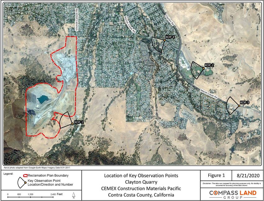
lake. Figure 4.1-1, “Location of Key Observation Points,” shows the location of each viewpoint. Figure 4.1-
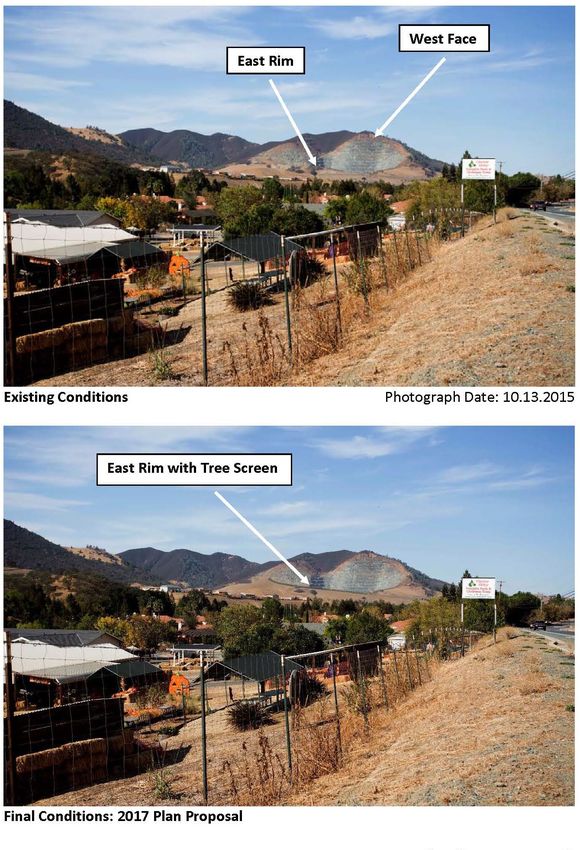
2, “KOP 1: View from Mount Diablo State Park (Looking Northwest),” Figure 4.1-3, “KOP 2: View from
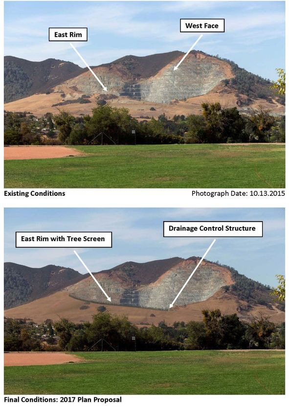
Clayton Community Park (Looking West),” Figure 4.1-4, “KOP 3: View from Marsh Creek Road (Looking
West),” and Figure 4.1-5, “KOP 4: View from Marsh Creek Road and Easley Drive (Looking Southwest),”
show photographs of the existing viewpoints and simulations of the proposed conditions at the existing
viewpoints, as described in the following list:

    •    KOP 1 (Medium-High): This viewpoint is located at the Mitchell Canyon entrance to Diablo State
         Park at the southern terminus of Michell Canyon Road and is oriented northwest toward the
         southeastern portion of the project site, the east rim of the quarry pit, and the west face of Mount
         Zion. Viewers would include park visitors and employees, including drivers, cyclists, and
         pedestrians. The quality of this view is considered medium-high because while the view includes
         open space lands, the area is disturbed by mining. The foreground view includes barbed-wire
         fencing in front of open space covered with grass and shrubs. Middle-ground views include rolling
         hills covered in oak woodland and the quarry pit east rim. The West Face of Mount Zion dominates
         the background view, which also features exposed rock and quarry benches from past mining
         activity.
    •    KOP 2 (Medium): This viewpoint is located at the northern terminus of Regency Drive and the
         Clayton Community Park and is oriented west toward the center of the project site and the West
         Face of Mount Zion. Viewers would include residents of the Regency-Woods and Diablo Estates
         residential communities, students and employees of Diablo View Middle School, and visitors of
         the Community Park. The quality of this view is considered medium because while the view
         includes open space lands, the area is disturbed by mining and visible residential neighborhoods.
         The view includes foreground views of baseball fields separated by a riparian corridor with trees,
         middle ground views of residential homes between trees, and background views of the West Face
         of Mount Zion and the project site, including the plant site, exposed rock face and east rim of the
         quarry pit, the access road, and open space.
    •    KOP 3 (Medium): This viewpoint is located on the west side of Marsh Creek Road near Pine Lane
         in southeast Clayton and is oriented west toward the center of the project site and the West Face of
         Mount Zion. Viewers would primarily consist of drivers on Marsh Creek Road (travelling at
         approximately 45 miles per hour), as no bike or pedestrian paths are located in the vicinity. The
         quality of this view would be medium because, while the view includes open space in the
         background, views are brief (mainly visible for passengers) and of the mined Mount Zion West
         Face and commercial and residential areas of Clayton. The view includes Marsh Creek Road and
         commercial property separated by a wire fence in the foreground, open space, and residential areas
         of Clayton in the middle ground, and the mined Mount Zion West Face and east rim surrounded
         by open space in the background.
    •    KOP 4 (Medium-High): This viewpoint is located at the intersection of Marsh Creek Road and
         Easley Drive and is oriented southwest toward the northern end of the project site. Viewers would
         include drivers traveling approximately 45 miles per hour (mph) (or 25 mph when children are
         present)) on Marsh Creek Road, drivers traveling approximately 25 mph on Easley Drive,

February | 2022                                                                                               4.1-3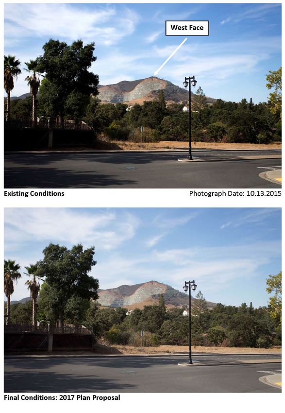
CLAYTON QUARRY RECLAMATION PLAN AMENDMENT
4.1—Aesthetics and Visual Resources                                                                           DRAFT EIR

          pedestrians on sidewalks and the nearby trail within Regency Woods Park, and cyclists. While the
          view includes some open space lands and the riparian area of Mount Diablo Creek, the area is
          disturbed by mining and visible residential neighborhoods. The foreground views consist of Marsh
          Creek Road, fenced residential property, and an open field leading to Regency Woods Park. Middle
          ground views include the riparian corridor of Mount Diablo Creek, and background views include
          residences between trees and the mined Mount Zion West Face.

4.1.2         Regulatory Setting
No federal regulations relevant to the visual impact analysis presented herein apply to the project. Relevant
state and local programs and policies are discussed below.

4.1.2.1       State
California Scenic Highway Program
In 1963, the California legislature created the Scenic Highway Program to protect scenic highway corridors
from changes that would diminish the aesthetic value of lands next to the highways. The state statutes
governing the Scenic Highway Program are found in the Streets and Highways Code, Section 260 et seq.
State and local agencies are responsible for protecting the social and economic values provided by the
State’s scenic resources through the development of specific planning and design standards and
procedures. A highway may be designated as “scenic” depending on how much of the natural landscape
can be seen by travelers, the scenic quality of the landscape, and the extent to which development intrudes
upon travelers’ enjoyment of the view. A list of state scenic highways is identified in Streets and Highway
Code Section 263. No highways near the project site are designated as scenic (Caltrans 2020).

4.1.2.2       Local
Contra Costa County General Plan
The Contra Costa County General Plan serves as the applicable general plan document for the area in which
the project site is located. Relevant goals and policies are listed below.

    Land Use Element
    Goal 3-G:         To discourage development on vacant rural lands outside of planned urban areas which
                      is not related to agriculture, mineral extraction, wind energy, or other appropriate rural
                      uses; discourage subdivision down to minimum parcel size of rural lands that are within,
                      or accessible only through, geologically unstable areas; and to protect open hillsides and
                      significant ridgelines.

                      Policy 3-12:    Preservation and buffering of agricultural land should be encouraged as
                                      it is critical to maintaining a healthy and competitive agricultural
                                      economy and assuring a balance of land uses. Preservation and
                                      conservation of open space, wetlands, parks, hillsides and ridgelines
                                      should be encouraged as it is crucial to preserve the continued availability
                                      of unique habitats for wildlife and plants, protect unique scenery, and
                                      provide a wide range of recreational opportunities for county residents.

4.1-4                                                                                                 February | 2022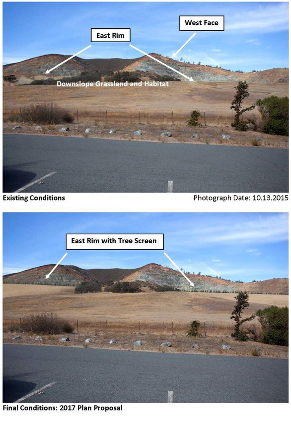
SOURCE: Compass Land Group 2020; modified by Benchmark Resources in 2021
NOTE: Figure is not to scale.

                                                                                        Location of Key Observation Points
                                                                           CLAYTON QUARRY RECLAMATION PLAN AMENDMENT
                                                                                                                DRAFT EIR
                                                                                                              Figure 4.1-1
CLAYTON QUARRY RECLAMATION PLAN AMENDMENT
4.1—Aesthetics and Visual Resources DRAFT EIR
THIS PAGE
INTENTIONALLY
LEFT BLANK
4.1-6 February | 2022SOURCE: Compass Land Group 2018; compiled by Benchmark Resources in 2021
Key Observation Point (KOP) 1:
View from Mount Diablo State Park (Looking Northwest)
CLAYTON QUARRY RECLAMATION PLAN AMENDMENT
DRAFT EIR
Figure 4.1-2CLAYTON QUARRY RECLAMATION PLAN AMENDMENT
4.1—Aesthetics and Visual Resources DRAFT EIR
THIS PAGE
INTENTIONALLY
LEFT BLANK
4.1-8 February | 2022SOURCE: Compass Land Group 2018; compiled by Benchmark Resources in 2021
KOP 2: View from Clayton Community Park (Looking West)
CLAYTON QUARRY RECLAMATION PLAN AMENDMENT
DRAFT EIR
Figure 4.1-3CLAYTON QUARRY RECLAMATION PLAN AMENDMENT
4.1—Aesthetics and Visual Resources DRAFT EIR
THIS PAGE
INTENTIONALLY
LEFT BLANK
4.1-10 February | 2022SOURCE: Compass Land Group 2018; compiled by Benchmark Resources in 2021
KOP 3: View from Marsh Creek Road (Looking West)
CLAYTON QUARRY RECLAMATION PLAN AMENDMENT
DRAFT EIR
Figure 4.1-4CLAYTON QUARRY RECLAMATION PLAN AMENDMENT
4.1—Aesthetics and Visual Resources DRAFT EIR
THIS PAGE
INTENTIONALLY
LEFT BLANK
4.1-12 February | 2022SOURCE: Compass Land Group 2018; compiled by Benchmark Resources in 2021
KOP 4: View from Marsh Creek Road and Easley Drive (Looking Southwest)
CLAYTON QUARRY RECLAMATION PLAN AMENDMENT
DRAFT EIR
Figure 4.1-5CLAYTON QUARRY RECLAMATION PLAN AMENDMENT
4.1—Aesthetics and Visual Resources DRAFT EIR
THIS PAGE
INTENTIONALLY
LEFT BLANK
4.1-14 February | 2022CLAYTON QUARRY RECLAMATION PLAN AMENDMENT
DRAFT EIR 4.1—Aesthetics and Visual Resources
Conservation Element
Policy 8-1: Resource utilization and development shall be planned within a
framework of maintaining a healthy and attractive environment.
Policy 8-21: The planting of native trees and shrubs shall be encouraged in order to
preserve the visual integrity of the landscape, provide habitat conditions
suitable for native wildlife, and ensure that a maximum number and
variety of well-adapted plants are sustained in urban areas.
Open Space
Goal 9-A: To preserve and protect the ecological, scenic, cultural/historic, and recreational resource
lands of the county.
Policy 9-2: Historic and scenic features, watersheds, natural waterways, and areas
important for the maintenance of natural vegetation and wildlife
populations shall be preserved and enhanced.
Policy 9-4: Where feasible and desirable, major open space components shall be
combined and linked to form a visual and physical system in the county.
4.1.3 Significance Criteria and Analysis Methodology
4.1.3.1 Significance Criteria
Based on Appendix G of the CEQA Guidelines, the proposed project would have a significant impact to
aesthetics if it would:
a) have a substantial adverse effect on a scenic vista;
b) substantially damage scenic resources, including, but not limited to, trees, rock outcroppings, and
historic buildings within a state scenic highway;
c) in nonurbanized areas, substantially degrade the existing visual character or quality of public
views (i.e., views experienced from publicly accessible vantage points) of the site and its
surroundings. If the project is in an urbanized area, would the project conflict with applicable
zoning and other regulations governing scenic quality; or
d) create a new source of substantial light or glare which would adversely affect day or nighttime
views in the area.
4.1.3.2 Analysis Methodology
To identify viewpoints, or KOPs, from which the project may visible, Compass Land Group and Rocket
Red Media studied the project area on October 13, 2015. Conditions at the project site have not substantially
changed since site photos were taken on this date. The analysis of viewpoints was limited to representative
locations determined to have the potential for the project site to dominate or substantially alter the view.
Potential viewers of the project site consist of drivers on nearby roads, nearby residents, and people visiting
nearby businesses and parks. Computer simulations were generated from the same KOPs from which the
existing photographs were taken. Project-specific information available at the time the simulations were
created (e.g., expected lake depths, sizes, berm slopes and heights, related facilities) was included in the
computer simulations.
Existing aerial photographs, topography, and County literature (e.g., Contra Costa County General Plan
[Contra Costa County 2014]) were reviewed to assess the visual quality of the area. Elements considered in
February | 2022 4.1-15CLAYTON QUARRY RECLAMATION PLAN AMENDMENT
4.1—Aesthetics and Visual Resources DRAFT EIR
determining the project’s change to the visual character of the site or surroundings included the degree of
natural or project-proposed tree screening, topography, screening berm, relative size of project features
and components, and the length of time the features are in view.
The procedure for analysis in the visual assessment was based, in part, on the visual impact assessment
methodology employed by the Federal Highway Administration, the Bureau of Land Management (BLM),
and the U.S. Forest Service. The assessment was conducted in a series of steps:
1. defining the project setting and viewsheds;
2. identifying sensitive view receptors for assessment;
3. analyzing the baseline visual quality and character of the identified views;
4. depicting the visual appearance of the project from the identified views;
5. assessing the project’s impacts to those views in comparison to their baseline visual quality and
character; and
6. proposing methods to mitigate potentially significant visual impacts identified.
To assess the potential for aesthetic impacts associated with implementation of the project, the analysis
focuses on the degree to which the project directly and/or indirectly diminishes or enhances the existing
visual quality and character of the natural environment. The analysis depends largely on the visual contrast
created between the project and the existing landscape. Visual contrast is measured by comparing the
project’s features with the major features in the existing landscape. While an assessment of potential visual
impacts is by nature somewhat subjective, qualitative criteria such as an evaluation of basic design elements
of form, line, color, and texture are used to make this comparison and describe the visual contrast created
by the project.
4.1.4 Project Impacts and Mitigation Measures
Impact 4.1-1: Substantial Adverse Effect on a Scenic Vista
The proposed project is not located within or within view of a scenic vista (Contra Costa County 2014).
Therefore, implementation of the proposed project would have no impact on a scenic vista.
Level of Significance: No impact.
Mitigation Measure: None required.
Impact 4.1-2: Substantially Damage Scenic Resources Within View of a Scenic Highway
The proposed project is not located near or within view of a scenic highway (Caltrans 2020). Therefore,
implementation of the proposed project would have no impact on a scenic highway.
Level of Significance: No impact.
Mitigation Measure: None required.
4.1-16 February | 2022CLAYTON QUARRY RECLAMATION PLAN AMENDMENT
DRAFT EIR 4.1—Aesthetics and Visual Resources
Impact 4.1-3: Substantial Degradation of the Existing Visual Character or Quality of the Site
and Its Surroundings
Figure 4.1-1 provides a map of the KOP locations. Figures 4.1-2 through 4.1-5, show photographs of the
existing viewpoints and simulations of proposed conditions for the existing viewpoints. As represented
in the simulations, the differences between the existing and proposed conditions are evaluated below:
• KOP 1: As shown in Figure 4.1-2, the proposed project from this viewpoint would result in
foreground views similar to existing conditions, including barbed-wire fencing in front of open
space covered with grass and shrubs. Middle-ground views would be similar in character to
existing conditions, but they would include the newly graded downslope grassland for the
overburden fill areas, removal of some existing trees (discussed in greater detail in Section 4.3,
“Biological Resources”), and addition of the east rim tree screen. The east rim tree screen would
feature 400 foothill pines lined up along the rim to obscure a portion of the exposed rock face.
The West Face of Mount Zion would continue to dominate the background view, including the
exposed rock and quarry benches from past mining activity. Views of the proposed project
from this viewpoint would be improved compared to existing conditions because the views
would provide a more natural, landscaped setting and the tree screen would provide some
cover of the existing exposed rock and quarry benches. While the existing view and visual
simulation are from the vantage point of the park entrance, park users that would view the
proposed project site from the trails and northern portion of the park would be expected to
have similar vantage points, and the impact determination would be the same for all park users
at Mount Diablo State Park.
• KOP 2: As shown in Figure 4.1-3, the proposed project from this viewpoint would result in
similar foreground views to existing conditions, including baseball fields separated by a
riparian corridor with trees. Middle ground views would still feature residential homes visible
in between mature trees as the landscape slopes upwards out of the valley. However,
background views of the West Face of Mount Zion and the project site would feature a more
uniform slope at the overburden fill areas, the east rim tree screen, and the reclaimed plant site.
The drainage control structure would not be visible from this viewpoint. Views of the proposed
project from this viewpoint would be of improved quality compared to existing conditions
because the views would provide a more natural, landscaped setting.
• KOP 3: As shown in Figure 4.1-4, the proposed project from this viewpoint would result in
similar foreground views to existing conditions, featuring Marsh Creek Road and commercial
property separated by a wire fence. Middle ground views of would still include open space
and residential areas of Clayton. The background view of the West Face of Mount Zion and
the project site would appear similar in character to existing conditions, and the drainage
control structure would not be visible. The overburden fill areas would result in a more
natural-looking downward slope compared to the existing topography of the area, which
includes existing overburden deposits. In addition, the tree screen along the east rim would be
visible and obscure a small portion of the quarry rock face, resulting in a beneficial visual
impact. Overall, the increase in plantings and the tree screen would not degrade the character
of the view and may be considered to result in a more natural setting. Therefore, the quality of
views under the proposed project would be improved compared to existing conditions.
• KOP 4: As shown in Figure 4.1-5, the proposed project from this viewpoint would result in
foreground views similar to existing conditions, featuring Marsh Creek Road, fenced single-
family residential property, and an open field leading to Regency Woods Park. Middle ground
February | 2022 4.1-17CLAYTON QUARRY RECLAMATION PLAN AMENDMENT
4.1—Aesthetics and Visual Resources DRAFT EIR
views would continue to primarily consist of the riparian corridor of Mount Diablo Creek.
Background views would also still include residences between trees and the mined Mount
Zion West Face, with the east rim tree screen serving as the primary notable change. Views of
the proposed project from this viewpoint would be of similar quality compared to existing
conditions. Overall, the differences between existing conditions and the proposed project
would result in improved views because the screening berm and tree screen along the East
Rim would decrease views of the existing exposed quarry benches, which are considered
undesirable. Also, removed trees would be replaced with 400 foothill pines, resulting in
additional trees, which are considered visually desirable. Overall, the proposed project would
provide a more natural setting, more native vegetation, and a higher quality of visual character
than under existing conditions. Therefore, the proposed project would result in a less-than-
significant impact on the visual character or quality of the site and its surroundings.
Level of Significance: Less than significant.
Mitigation Measure: None required.
Impact 4.1-4: Creation of a New Source of Substantial Light and Glare That Would Adversely
Affect Day or Nighttime Views in the Area
Construction equipment related to reclamation activities and security lighting may introduce glare or
light levels that could adversely affect nighttime views in the area. Potential sources of light and glare,
such as vehicles and structures, would be removed from the site upon the completion of reclamation
activities. The Applicant has agreed to Mitigation Measure 4.1-4, “Daily Limitation of Construction
Activities,” which limits reclamation activities to daytime hours. With the incorporation of Mitigation
Measure 4.1-4, no reclamation activities would occur at night, and the completed project would not
include lighting. Therefore, the project’s potential for creation of a new source of substantial light and
glare that would adversely affect day or nighttime views in the area would be less than significant with
mitigation.
Level of Significance Before Mitigation: Potentially significant.
Mitigation Measure 4.1-4: Daily Limitation of Reclamation-Related Construction Activities
All reclamation-related construction activities shall be limited to the hours of 7 a.m. to 7 p.m. Monday
through Friday.
Level of Significance After Mitigation: Less than significant.
4.1-18 February | 2022You can also read


