7:00 AM EDT Friday, July 31, 2020 Hurricane Isaias, Invest 93L (40 & Eastern Atlantic Tropical Wave (20%) - GovDelivery
←
→
Page content transcription
If your browser does not render page correctly, please read the page content below
Tropical Update
                                             7:00 AM EDT
                                         Friday, July 31, 2020

                       Hurricane Isaias, Invest 93L (40%),
                     & Eastern Atlantic Tropical Wave (20%)
This update is intended for government and emergency response officials, and is provided for informational and situational
awareness purposes only. Forecast conditions are subject to change based on a variety of environmental factors. For
additional information, or for any life safety concerns with an active weather event please contact your County Emergency
Management or Public Safety Office, local National Weather Service forecast office, or visit the National Hurricane Center
website at www.hurricanes.gov.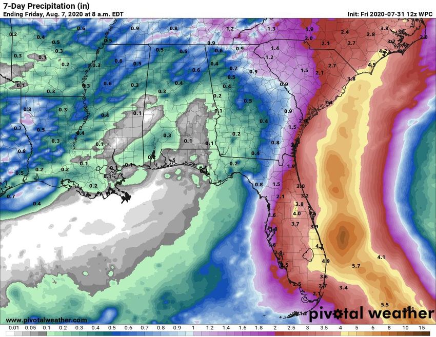
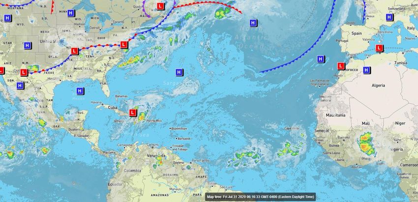
Atlantic Basin Satellite Image
Chance of development:   None   Low   Medium   High
Tropical Weather Outlook
Possible Areas of Development During the Next 5 Days (LINK)
Hurricane Isaias Friday, July 31
                       MINIMAL    LOW   MODERATE     HIGH      EXTREME       National Hurricane Center Map
             Winds

        Storm Surge

         Flash Flood

         Tornadoes

                            LOW         MODERATE             HIGH

Overview/Recent Changes:
Isaias strengthened overnight, becoming a Category 1 Hurricane with maximum sustained winds of 80 mph. Additional
strengthening is forecast over the next 48 hours as Isaias nears the East Coast of Florida. Tropical Storm Watches are in effect,
and additional watches and warnings are possible today. Small shifts in the track will have large changes on the impacts.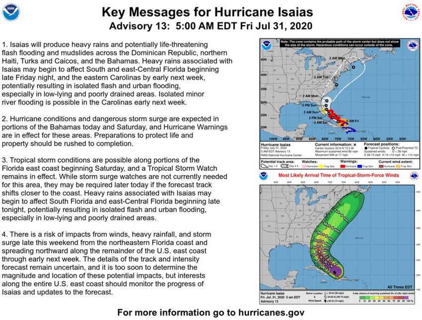
Official Forecast Track
From the National Hurricane Center – Hurricane Isaias
                              •   The center of Hurricane Isaias is about 550 miles southeast
                                  of Miami, Florida, moving to the NW at 17 mph.

                              •   Maximum sustained winds are around 80 mph, making it a
                                  category 1 hurricane.

                              •   Strengthening to a category 2 hurricane is forecast Saturday
                                  over the Bahamas (100 mph).

                              •   The system will approach the Florida East Coast Saturday
                                  then move away from Florida late Sunday and Monday.

                              •   There is still some uncertainty in whether the system comes
                                  onshore in Florida or if it remains offshore. Adjustments to
                                  the track and intensity forecast are still possible.

                              •   A stronger hurricane is more likely to remain east of Florida,
                                  while a weakening system may move onshore.

                              •   Tropical Storm Watches are in effect from Sebastian Inlet to
                                  Ocean Reef, including Lake Okeechobee
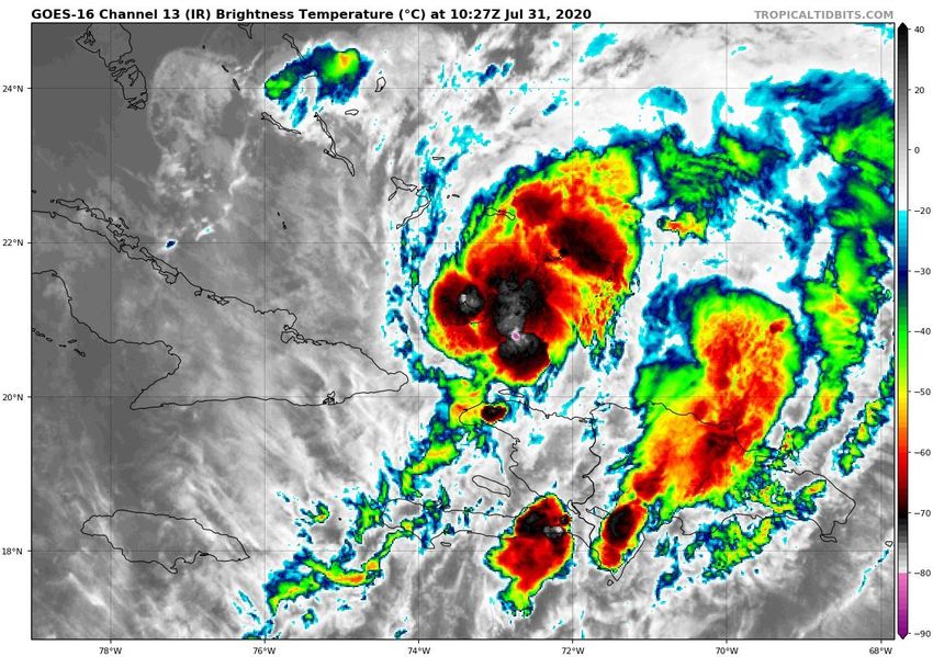
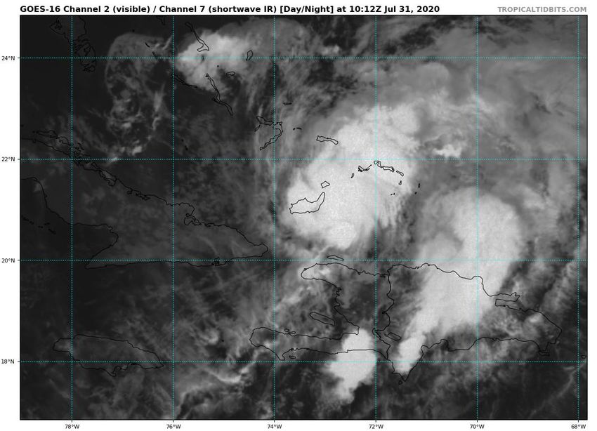
Satellite Imagery
Southwest Atlantic – Hurricane Isaias
                                        Isaias reorganized overnight as it moved away
                                           from the high mountains of Haiti and the
                                          Dominican Republic. Isaias will continue to
                                         organize today as it moves to the northwest
                                                     across the Bahamas.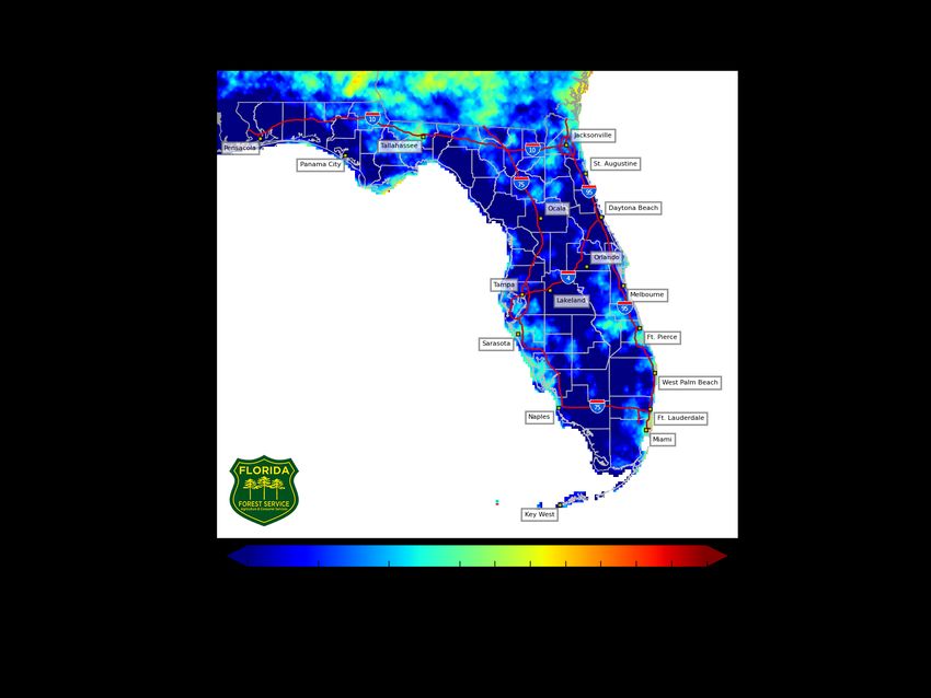
Color denotes the movement speed through
            Steering Currents            the atmosphere and thin white lines denote
                                            direction. Tightly clustered white lines
            What is moving the system?       represent faster movement as well.

Isaias will move northwestward                                          Fast Moving
 and the northward between a                                               Storm
 break in a large high pressure
             system.

                                                                        Fast Moving
                                                                           Storm

                                                                         Typical
                                                                       Moving Storm

                                                                        Slow Moving
                                                                           Storm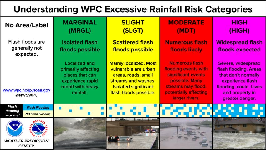
Model Forecasts
Dynamical Models – Hurricane Isaias

                               Note the large spread in the models
                             continues, as uncertainty continues with
                                how close Isaias will get to Florida.

                               Reds and oranges are stronger storms
                             (hurricanes), and tend to keep the storm
                                    east of Florida and offshore.

                                If the system weakens (greens and
                              blues, tropical storm to near hurricane
                                strength), it is more likely to move
                                onshore and bring more impacts to
                                               Florida.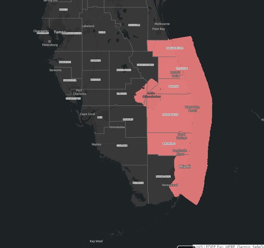
Time of Arrival & Wind Speed Probabilities
MOST LIKELY Time of Arrival of Tropical Storm Force Winds (>39 mph)

                                                          Key West: 3%
                                                         Miami: 20% (+2)
                                                         Naples: 8% (-2)
                                                   West Palm Beach: 54% (+10)
                       Jacksonville 12%             Ft. Lauderdale: 44% (+9)
                                                       Ft. Pierce: 54% (+8)
                                                    Daytona Beach: 22% (-1)
                           Orlando 30%                  Orlando: 16% (-2)
                                                         Tampa: 7% (-2)
                             Miami 9%                Jacksonville: 10% (-3)

                                            The most likely chance of tropical storm force
                                             winds starting will be Saturday morning in
                                           Southeast Florida, but could arrive AS EARLY AS
                                                             late tonight.
Damaging Wind Threat Overview
           Hurricane Isaias
The greatest wind threat is along the immediate coast
(Treasure Coast) of Southeast Florida, mainly along and
east of I-95.

Higher gusts to 70 mph may be possible Saturday and
Sunday as Isaias makes its closest approach.

                       https://www.weather.gov/srh/tropical?
                                     office=mfl
                         Click on “Threats and Impacts” Tab
Wind Watches and Warnings
In Effect Until Further Notice
Tropical Storm Watches are in
effect from Sebastian Inlet to
Ocean Reef, including Lake
Okeechobee
Counties: Indian River, St.
Lucie, Martin, Palm Beach,
Broward, coastal and metro
Miami-DadeHurricane Wind Speed Probabilities
Probabilities of Sustained Hurricane Force Winds (>74 mph)
Only ~5% along the
Treasure Coast.Storm Surge Threat Overview
Hurricane Isaias
Only minor coastal flooding is expected in Southeast
Florida, as storm surge of 1-2’ is forecast.
*However, Northeast Florida will be monitored, and
details may become available later today.*
There are no storm surge watches or warnings in
effect.
https://www.weather.gov/srh/tropical?
office=mfl
Click on “Threats and Impacts” TabKey Messages From the National Hurricane Center
Forecast Wave Heights
           This Weekend

  Friday                                 Saturday                                Sunday

High surf of 8-11 feet is expected along East Coast beaches this afternoon. This will result in dangerous rip
                           currents. Minor to significant beach erosion is expected.
Rip Current Outlook
Today
Rough surf and high water levels will keep the
rip current risk high at Atlantic beaches
through the weekeknd.Flash Flood Outlook - Saturday
From the Weather Prediction Center (LINK)
Isolated flash flooding is
possible along the East
Coast from Brevard
County southward as
Isaias approaches.Rain Chances Next 3 Days
Friday Saturday Sunday
Night
Rain chances in Southeast Florida will begin tonight, then across the Peninsula
on Saturday, and into Northeast Florida by Sunday.Forecast Rainfall Totals Next 7 Days • About 4-6” of rain are possible along the East Coast, 2-4” inland • Localized totals double these amounts will be possible. • Isolated flash flooding possible, especially in the urban areas of Southeast Florida • A western track would lead to higher rainfall totals across the Peninsula • An eastern track would lower rain totals and keep most of the rain offshore.
Streamflow Anomaly – Soil Moisture
                KB Drought Index – Full Report from the Florida Forest Service

                                                                   Streamflows are near to
                                                                   below normal across the
                                                                     entire Peninsula, but
                                                                       soils remain quite
 The rivers in RED are                                                saturated. If heavier
currently at lower than                                               rainfall occurs, then
                                       The areas in DARK
 normal levels for this                                             flash flooding will be a
                                         BLUE are most
     time of year.
                                      susceptible to Flash                  concern.
                                          Flooding and
                                         currently have             Most rivers are able to
                                        saturated soils.            handle 3-5” of rainfall,
                                                                    but flooding concerns
                                                                     may rise if heavier
                                                                       rainfall occurs.
Flash Flood Guidance
How Much Rain is Needed to Create Flash Flooding?
In general, more than 3 or 4” of rain
in a short period of time will result in
flash flooding.Tropical Weather Outlook
Possible Area of Development During the Next 5 Days (LINK)
An area of low pressure located a couple of
hundred miles east-southeast of the Cabo Verde
Islands is producing disorganized showers and
thunderstorms. This low has a small window of
opportunity to become a tropical depression today
while it moves northward at about 10 mph before
environmental conditions become less conducive
for development.
The next name on the list is Josephine.
This system does not pose a threat to Florida.Model Forecast Tracks
Ensembles, Dynamical, and Statistical Models
Invest 93L will hook around the Cabo Verde Islands before dissipating in
about 48 hours.Tropical Weather Outlook
Possible Area of Development During the Next 5 Days (LINK)
A westward-moving tropical wave located about
1000 miles east of the Lesser Antilles is producing a
limited amount of shower activity. Some slow
development of this system is possible while
it turns northwestward over the western Atlantic
early next week.
The next name on the list is Josephine.
This system does not pose a direct threat to Florida
at this time.Overall Summary Hurricane Isaias • Isaias continued to reorganize overnight, with the center located about 550 miles southeast of Miami, FL, moving northwest at 17 mph. • Maximum sustained winds are near 80 mph (Category 1 Hurricane). Strengthening is forecast, and Isaias is forecast to become a category 2 hurricane with winds near 100 mph on Saturday in the Bahamas. • Thereafter, some weakening may occur as the system nears Florida and turns northward. More weakening would tend to mean a track closer to Florida, where a stronger hurricane is more likely to remain offshore. • A north to northeast motion is expected early next week with the system paralleling the East Coast of the United States. Invest 93L (Cabo Verde Islands) • A tropical wave near the Cabo Verde Islands is showing some signs of organization. Environmental conditions are currently favorable for development, but only over the next 36 hours. • This system has a 40% chance of forming into a tropical depression before moving over colder waters. • This system poses no threat to Florida. Eastern Atlantic Tropical Wave • A tropical wave about halfway between the Caribbean and Africa is producing limited shower activity as it moves west. • Some slow development of this system is possible next week while it turns northwest over the western Atlantic. • This system is not forecast to be a direct threat to Florida, but may prolong the rip current risk into next week.
Overall Summary
Florida Outlook:
• Isaias poses a direct threat to Florida starting as early as tonight, but more likely beginning Saturday morning.
• Tropical Storm Watch: Indian River, St. Lucie, Martin, Palm Beach, Broward, coastal and metro Miami-Dade
• Wind gusts from 40-65 mph are generally forecast in the watch area on Saturday and Sunday.
• Heavy rainfall of 4-6” with localized totals possibly double that will be possible across the East Coast. Rainfall will be
   dependent on the track of Isaias.
• Soils remain saturated from the fairly active wet season across much of the Peninsula, which could lead to an elevated flash
   flood threat this weekend.
• Streamflows in the Peninsula are running near to below normal, and it may take more than 3-5” of rain to cause flooding
   issues along the rivers in the Peninsula.
• Isolated tornadoes may be possible, especially if the center moves over the state.
• It remains too early to get specific about storm surge impacts to the state, but the potential exists for some storm surge
   impacts along the East Coast, particularly in Northeast Florida. Only 1-2’ is currently forecast in Southeast Florida.
• Elevated surf, dangerous rip currents, and beach erosion will be likely at most Atlantic beaches this weekend.

The next briefing packet will be issued later this morning with the 11 AM ET advisory. For the latest information on the tropics,
please visit the National Hurricane Center website at www.hurricanes.gov.
Tropical Update
                                     Created by:
                     Michael Spagnolo, Deputy State Meteorologist
                        Michael.Spagnolo@em.myflorida.com
                        State Meteorological Support Unit
                   Florida Division of Emergency Management

Users wishing to subscribe (approval pending) to this distribution list, register at:
https://public.govdelivery.com/accounts/FLDEM/subscriber/new?topic_id=SERT_Met_Tropics.
Other reports available for subscription are available at:
https://public.govdelivery.com/accounts/FLDEM/subscriber/new?preferences=true
You can also read