A brief introduction to London's underground railways and land use
←
→
Page content transcription
If your browser does not render page correctly, please read the page content below
http://jtlu.org
Vol. 7 no. 1 [2014] pp. 105-116 doi: 10.5198/jtlu.v7i1.411
A brief introduction to London’s underground railways and land use
Nathan Darrocha
London Underground
Abstract: The most common perception of London’s underground railways and land use is that the railway stimulated suburban development
and growth of the city. However, the interface between the railway, private property interests, and urban and suburban development is much
more complicated than this. This paper introduces a brief overview of the interrelationship between the railway and land use in the central
zone of London and some of the complexities involved with the presence of the railway and the development or use of adjoining lands. As this
topic appears to be little discussed, evidence is used from London Underground records and specialist knowledge to form the argument that
the topic should have greater discussion academically and practically.
1 Introduction railway now affects the development and use of land.
To cover the different aspects of the railway and its rela-
When the world’s first underground railway, the Metropoli- tionship to land use and urban design fully would require a
tan Railway, was opened in 1863, it was less than forty years whole series of papers, constituting many volumes. Each as-
after the opening of the world’s first public railway to use a pect has its own difficulty in presence, design, and ability to be
steam locomotive to haul a passenger train between two urban incorporated within the urban realm. For the purposes of this
centers (the Stockton and Darlington Railway, 1825). By the paper concentration is specifically given to the central zone,
time of the Metropolitan Railway, main line railways, using the extending outwards to key locations of interest, to demonstrate
initial principles of the Stockton & Darlington Railway and some of the issues involved. Its purpose is to demonstrate that
the Liverpool and Manchester Railway (1830), had already ar- the transport and land use researcher, engineer, surveyor, and
rived in London, causing much demolition of property and the historian must look beyond what obvious effects the under-
conversion of land from residential and commercial use to rail- ground railway has had on land use and consider how the rail-
way specific purposes (Dyos, 1955; Kellett, 1993). The effects way and land use affect each other, why, and how they will do
of these railways on the city is apparent today by the loss of so in future.
developable areas, thus creating swathes of land and air space,
which can have no other purpose than for limited use as small 1.1 A note on use of terms
industrial units, mostly in railway arches. The decline in the
requirement for engine sheds, sidings, carriage-stabling facili- Whereas the phrase ‘the tube’ is commonly used in reference to
ties, and goods sheds has resulted in the reclaiming of railway the whole of London’s’ underground railway network, its use
land for commercial and residential development where once is inaccurate. The ‘tubes’ are the deep level bored tunnels con-
the land was put to solely railway purposes. structed using a tunnelling shield or tunnel boring machines,
The benefits of an underground railway are apparent such as the Northern and Victoria lines. The earlier lines, such
when general consideration is given to them. While there is as the Metropolitan and Circle, on the other hand, were con-
much discussion on the issue of transport systems on urban structed using traditional mining methods and by the cut and
development, especially main line railways (Levinson, 2008; cover technique, and are referred to as the sub-surface railways.
Kellett, 1969), there appears to be little discussion of the inter- This paper therefore uses the term ‘underground’ to encapsu-
relationship between London’s underground railways and how late the whole of London’s underground railway. Where the
land use, property rights and interests, have had an effect and term ‘the tube’ or ‘tube’ is used, it is in its correct form to de-
continue to affect one another. This paper therefore introduces scribe a deep tube tunnel.
some of the key aspects relating to the underground railways,
considering how land use and property interests initially af-
fected the location of the railways, and how the presence of the
a
nathan.darroch@tube.tfl.gov.uk
Copyright 2014 Nathan Darroch
Licensed under the Creative Commons Attribution – NonCommercial License 3.0.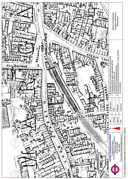
106                                                                                 JOURNAL OF TRANSPORT AND LAND USE 7.1

1.2      Historical overview                                        are some of the key points.

The Metropolitan Railway was first speculated in the early          2.1      The railway under the public highway
1850s, to run from Paddington, a residential suburb and the
location of a main line railway terminus to Farringdon, near        The railway had little long-term effect on land use and property
the financial center of the British Empire. Its purpose was to      adjacent to its alignment between Kings Cross and Padding-
tap into existing traffic flows heavily served by omnibuses, and    ton. This is due to its being limited, to some degree, to being
to compete for the traffic that these omnibus services had de-      away from private property and located under public highway
veloped (Jackson, 1986, p.18). Upon opening, it was instantly       (Kellett, 1969, p.50), fig. 1. What is required, however, is for
popular and stimulated government proposals for a circular          property developers and landowners to take into account the
railway around the central zone of the metropolis. This latter      effect any re-development of their property will impose on the
railway took twenty years to complete and forms today’s Circle      presence of the railway. For example, if one of the adjoining
line. Outside of this railway, branches from the Metropolitan       buildings were to be demolished, the developers’ engineers
and Circle lines extended outwards into the suburbs, further        would need to take into account ground movement, and man-
stimulating housing development and commuter traffic.               age the construction to ensure the support of the railway tun-
      The popular but limited benefit the early sub-surface rail-   nel.
ways gave to the central areas of London caused the speculation
of tube railways, all of which were planned to pass through         2.2      Tunnelling under property
the city center and thus provide easier access to the west end
and the City from the suburbs, such as Stockwell, Kensington,       Though the railway was predominantly under the public high-
Finsbury Park, Shepherds Bush, and Paddington. By 1907, the         way, there were locations where the railway was required to
cores of these routes were complete and running fast, frequent      pass under, or purchase and demolish privately owned, already
services. Eventually, they were extended further out into the       developed land. Great Portland Street and Edgware Road Sta-
suburbs, in tunnel and on the surface, as had the earlier sub-      tions are such examples. This brings us to the requirement for
surface railways.                                                   the railway company to accommodate land and property. At
      With the capacity problems on the existing London trans-      Great Portland Street, the railway was still predominantly lo-
port networks, electrification of former steam-operated main        cated under the road; though its western end was tunnelled
line railways was undertaken along with the proposal for a          under property, in ‘The Crescent’ (figs. 2 and 3). Whereas the
new tube railway to run from the northeast corner of the city       railway company would have had to undertake works to ensure
(Walthamstow) to Brixton via the central zone. This opened in       support for the existing buildings, the presence of the railway
sections from the late 1960s to the early 1970s as the Victoria     over the long-term potentially limits what can be done to the
line, not only was it the first automated railway in the world,     properties without possible substantial, expensive works to en-
but it was also the first of the underground railways entitled to   sure that the railways assets are not adversely affected. As such,
take the sub-soil and lands it required with only the payment of    the property owner will need to determine how much money
compensation (British Transport Commission Act 1955). All           they are willing to pay for the re-development of their property
of the earlier railways had had to buy either property or ease-     and what financial return they could gain from it, especially as
ments. The Brixton extension was also the first to introduce        they would be potentially limited to what they could do, from
a ‘protective sleeve’ around the tunnel to help ensure that the     a town planning and design perspective anyway.
railway would not be affected by development of land above it
(London Transport Act 1966), a feature prevalent on the Jubi-       2.3      Limiting development
lee line extension, opened in 1999 (Darroch, 2012).
                                                                         A substantial effect of the presence of the Metropolitan
                                                                    Railway in the east is its presence limiting development. When
2        The sub-surface railways and land use
                                                                    the Metropolitan Railway was under construction between
Perhaps one of the key discussion points of the development         Kings Cross and Farringdon demolition of property had al-
of the sub-surface railways, especially the Metropolitan Rail-      ready been undertaken, for the construction of Farringdon
way, was the disruption caused to property and traffic along        Road in the early 1850s (Jackson, 1986, p.19). The railway
its line of route during construction. However, there are ad-       therefore had very little short-term effect on property in this
ditional issues regarding the interrelationship between the sub-    area. However, it does have a long-term effect by reducing the
surface railways, private property, and land use. The following     developable land, a factor also pertinent to the construction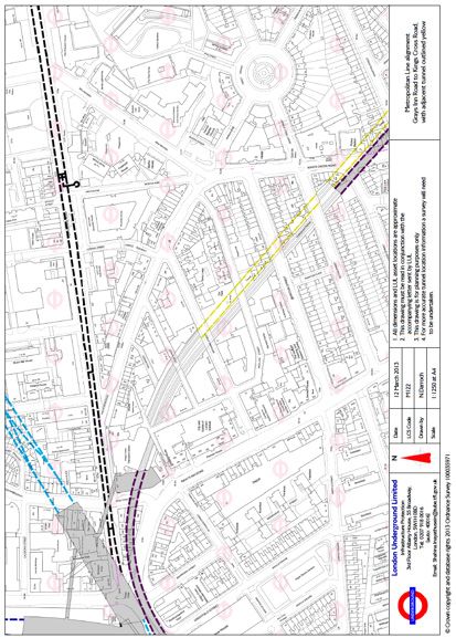
A brief introduction to London’s underground railways and land use 107
Figure 1: A 1:5000 at A3 plan, showing the alignment of the Metropolitan line (outlined dashed red and shaded gray) between
Great Portland Street and Baker Street Stations, overlaid on 2013 OS mapping. Note how the railway is located solely under the
public highway.
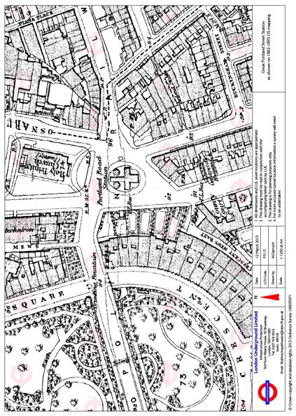
Figure 2: A 1:1250 at A4 plan, showing Great Portland Street Station on 1862-1895 OS mapping, note, how the railway tunnels
pass under the buildings to the west of Great Portland Street Station.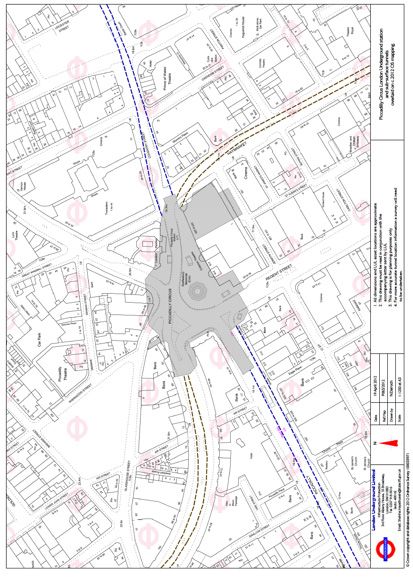
108                                                                                      JOURNAL OF TRANSPORT AND LAND USE 7.1

      Figure 3: A 1:1250 at A4 plan, showing Great Portland Street Station on 2013 OS mapping, note, how the railway tunnels pass
      under the buildings to the west of Great Portland Street Station.

      Figure 4: 1:1250 at A4 plan, showing the alignment of the Metropolitan line, between Grays Inn Road and Kings Cross Road,
      on 2013 OS mapping. Also shown is the alignment of the adjacent brick-arch Network Rail tunnel (dashed yellow). The blue and
      black lines are the alignments of the deep tube tunnels for the Victoria and Northern lines respectively.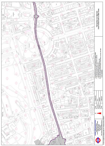
A brief introduction to London’s underground railways and land use                                                                      109

of the Circle line in the west, between Paddington and South             3        The deep tube railways and land use
Kensington, though in instances on the latter section this has
been overcome. Between Gray’s Inn Road and Kings Cross                   When the early tube railways were promoted and constructed
Road, the railway is located in deep cutting (fig. 4). Due to the        between 1885 and 1907, their principle alignment was under
proximity of a brick railway tunnel, parallel to the railway cut-        the public highway, in much the same way that the majority
ting, and adjoining properties constructed above the cutting             of the Metropolitan Railway, between Kings Cross and Pad-
retaining walls and the tunnel, the bridging over of the railway         dington and the extension to Finchley Road, had been. As with
is difficult and has thus resulted in a swathe of land, which can        the Metropolitan Railway, this was due to the financial savings
only be used for the purposes of the railway. This will continue         by not tunnelling under property, the land under the public
to be the case unless a developer is willing to purchase the adja-       highway considered as worthless to the adjoining landowners
cent properties and design an engineering solution, which will           (Joint Select Committee 1892, p.25). The main cost in this
not impose load on any of the existing railway structures.               period was therefore the construction of the railway and the
                                                                         purchase of property for stations. There were, however, loca-
2.4       Developing above the railway                                   tions where the railways had to pass under property, one ex-
                                                                         ample being where the City & South London Railway passed
      Whereas the last point suggests that there are difficulties in     under warehouses adjacent to the River Thames costing the
developing above the railway, there is an alternative possibility        company, £3,000 for an easement of fifty to sixty yards (Joint
for future development. This is the bridging over of the railway         Select Committee 1892, p.19). The granting of this easement,
and the locating of buildings in the air space above the railway.        however, did not grant the railway company any powers for
When the Metropolitan District Railway Company, opened                   the protection of its assets; it was only the right to the sub-soil
its St James’s Park Station in 1868, the station was in an open          through which its tunnel and trains were to pass. With the ex-
cutting with a substantial glass roof (fig. 5). Today, however, the      tensions of the tubes from 1913 until the 1940s, the railways
station is barely noticeable due to its inclusion within an office       began passing under property, but as with the City & South
development, located above it (fig. 6). This was facilitated by          London, this was subject to the purchase of easements, which
the spanning of the railway by a raft supported on piles, which          could considerably drive up costs of delivering the new railway.
does not transfer load from the development on to the railway
retaining walls, constructed between 1927 and 1931. Whereas              3.1      Initial minimal effect on property
the owners of the underground railways (the Underground
Electric Railways Company of London) undertook this work,                During this time, the presence of the railways under property,
it has set a precedent that has been copied over several places          as long as they were a substantial depth below, had minimal ef-
in the central area of London, such as Gloucester Road sta-              fect on the development of land, due to the low-rise nature and
tion (fig. 7), where a retail development is located above the           shallow foundations of buildings at that time. However, once
originally uncovered station. Not only does such development             structures that are more substantial started to be constructed,
minimize loss of land for uses other than for the railway, it also       from the 1950s, the presence of a tube railway or a related as-
gains the railway an additional income, other than fares, that           set, such as an escalator shaft started to be problematic (Fig. 8).
can be used to continue the upgrading of the railway network.

2.5       The sub-surface railways and land use

What these brief points show, is that though the sub-surface
railways are located underground in the central area of the city,
whether in tunnel or cutting, they still have an effect on land
use, and that land use also has an effect on the railway. Whereas
this is very clearly a physical effect, there are also theoretical ef-
fects in the relationship as well, though these are more clearly
discerned by considering the presence of the deep tube railways
in the sub-soil, which also have a physical effect on property
development.
110                                                                                          JOURNAL OF TRANSPORT AND LAND USE 7.1

      Figure 5: 1:1250 at A4 plan, showing St James’s Park Station, with the District and Circle lines as show on 1862-1895 OS map-
      ping. Note the large area of densely developed central London that has been put over to railway use, despite the underground
      minimizing its effect on land use.

      Figure 6: 1:1250 at A4 plan, showing St James’s Park Station, with the District and Circle lines outlined dashed green and shaded
      gray, on 2013 OS mapping. The large area of gray to the east reflects the area developed as the head office of the Underground
      group in the 1920s, spanning the original station cutting.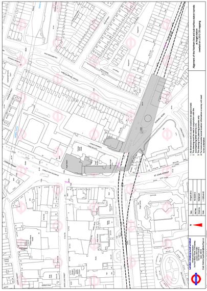
A brief introduction to London’s underground railways and land use                                                                             111

            Figure 7: 1:1250 at A4 plan showing Gloucester Road Station, with the District and Circle lines outlined dashed green and shaded
            gray, on 2013 OS mapping. Before the rafting over of the station it was in open cutting.

            Figure 8: 1:1250 at A3 plan, showing Angel Northern Line Station on the Bank branch of the Northern line. The gray shaded area
            extending north, represents the alignment of the escalator shaft constructed in the 1980s to replace the original lifts.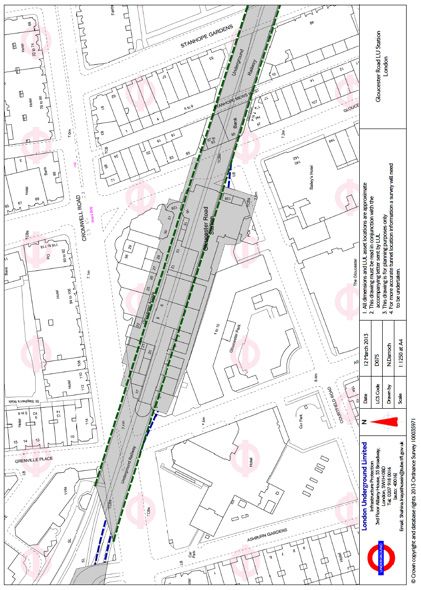
112                                                                                    JOURNAL OF TRANSPORT AND LAND USE 7.1

3.2       Providing additional facilities                              3.4      Ventilating the railway

Whereas the early tube stations used lifts to enable access to         A tube railway consists of more than its tunnels and surface
and from the trains, these began to restrict the flow of passen-       stations. They also need ventilation facilities, to ensure the
gers, examples of this restriction still notable at stations such as   fresh flow of air through the stations and tunnels. Whereas the
Covent Garden station on the Piccadilly line, which regularly          early tube stations were designed to accommodate ventilation
sees congestion and its use as an exit only, due to the use of lifts   through their station buildings and vent shafts, it was soon
instead of escalators. With the need to rebuild stations from the      found that this was unsatisfactory especially as user numbers
1920s, to cater for greater traffic flows, escalators were intro-      rose, trains became more frequent and distances between sta-
duced. To minimize their effect on adjoining properties, bear-         tions increased. The solution was to provide additional ventila-
ing in mind there was the issue of having to purchase an ease-         tion between stations. At one location in Pimlico, on the 1970s
ment through the sub-soil, many escalator shafts were located          built Victoria line extension from Victoria to Brixton, this re-
under the public highway. At Oval, where escalators replaced           sulted in the demolition of houses and the sinking of a venti-
lifts for example, the escalator shaft was purposefully driven         lation shaft down to tunnel level and its continuation above
under the road junction. At South Wimbledon on the Morden              ground level to approximately third floor level (fig. 10). The
extension of the Northern line, opened in 1926, the escala-            building constructed to contain the fans for forcing the air into
tor shaft and station tunnels are located under private property       and drawing it out of the tunnels, designed to blend into the
(fig. 9). This property, purchased by the railway company and          row of houses within which it was located. However, this has
sold on once the railway was complete, has covenants restrict-         resulted in a loss of land for purposes other than a railway that
ing what development can take place (Conveyance, dated 1               is a considerable depth below ground. If the properties either
March 1933). This is because the large diameter of the station         side were intended to be re-developed, the developers would
tunnels (about 7 metres), and the lack of space between them           need to take into account the presence of the shaft, next door.
and the escalator shaft, has restricted development due to the
minimal capacity for the foundations of any substantial devel-         3.5      Incorporating railway assets within new
opment. The only way to develop the land, currently in use                      development
as a car park, would be to purchase and demolish adjoining
property and to design a foundation solution that will trans-                Though the tubes require facilities as considered above,
fer building loads away from the railway structures. However,          they are not necessarily as disruptive to land use as the above
such a proposal, if planning permission could be gained and            examples may suggest. This is because, as with the sub-surface
property purchased, is likely to be prohibitive due to the cost.       railways, it is possible to incorporate them within new proper-
                                                                       ty development. Many of the stations for the Central London
3.3      The presence of the railway under property                    Railway, for example, were designed to accommodate property
                                                                       development above the surface building as well as to allow ven-
The above example can also be used to highlight the issues of          tilation (Joint Select Committee 1892 p.23.). This principle
the presence of the railway under property especially within the       has been continued through to present-day station design,
central zone of the metropolis. As mentioned above, building           with stations such as Southwark on the Jubilee line extension,
design from the 1950s has seen more substantial buildings be-          designed to be incorporated within future commercial devel-
ing erected, not only from ground level and above but also into        opment (Mitchell, 2003, p.160-163). With the rebuilding of
the subsoil; the larger the development the greater the need for       earlier stations, facility was also included to accommodate the
deeper foundations. Additionally there is the issue of size of         requirements of the railway, even where the station building
buildings, especially in locations where there is a restriction on     was no longer required. When Piccadilly Circus Station was
building height imposed by town planners. As such, develop-            reconstructed to provide an under-highway ticket hall, in the
ers are starting to build downwards with multiple basement             1920s the original station building, which incorporated a tick-
levels to create more floor space and revenue from their de-           et office, staff accommodation, an electrical sub-station, and
velopment. For those properties that had a tube railway con-           ventilation, did not fall out of use (fig. 11). Instead, it con-
structed under them, this becomes a problem for the engineers          tinued its use. This was even after the private redevelopment
and designers of new development, as they must now take into           of the site for commercial use as shops and offices. The new
account the presence of the railway, and potentially re-consider       development on the site, leased from London Underground,
their proposals for the scale and type of development they had         continues to provide facilities for ventilating the railway and
previously preferred.                                                  power provision, today. Thus demonstrating that the railway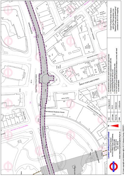
A brief introduction to London’s underground railways and land use                                                                                      113

can and is accommodated within commercial development
and thus minimizes its effect on land use.

     Figure 9: 1:1250 at A3 plan, showing South Wimbledon Station (shaded gray) on the Morden branch of the Northern line. The escalator shaft
     descends from the station building, on the east side of Merton Road, down between the station tunnels. The un-developable land is located in the
     center of the gray shaded area.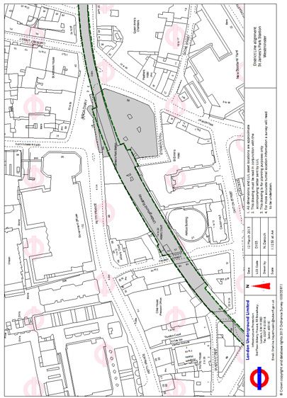
114                                                                            JOURNAL OF TRANSPORT AND LAND USE 7.1

      Figure 10: Photograph, showing the Head house building containing the ventilation shaft on the Brixton
      extension of the Victoria line. Note the adjoining private residential properties.
      Author, 2012. Victoria line head house, Pimlico.
A brief introduction to London’s underground railways and land use 115
Figure 11: 1:1250 at A3 plan, showing Piccadilly Circus Station (shaded gray) which serves the Piccadilly and Bakerloo lines. The original
station, replaced y the under highway ticket hall, and still utilised for operational purposes within an existing development is that portion of
gray shading to the south of the circus.
4 Conclusion regarding related sub-soil structures and how the presence of
these were again designed to minimize their affect on property,
The first section looked at the nature of the Metropolitan where possible. It showed that in some cases the avoidance of
line, using the section between Great Portland Street and Far- ‘land blight’ could not be avoided, and that the presence of the
ringdon. It considered how the railway is located under the railway under property, while initially not a major concern can,
public highway to minimize its incursion on private property, today, affect what development is undertaken and how. Con-
physically and legally, but pointing out that property must ac- sideration then turned to the need for purpose-built buildings
commodate the presence of the railway. The limitations on for the railway and how the assets within these can, on occa-
shallow structures under property demonstrating that the pres- sion, be incorporated in new commercial development.
ence of the tunnel can affect what kind of development can be This short paper has shown that though the railways are
undertaken. This was built upon by considering the presence below ground in the central zone, they have a complicated re-
of the railway in a cutting in an urban environment, and how lationship with property development, use of land and legal
redevelopment of neighboring property can be restricted by issues. Each affects the other in some way, whether it is seen or
the presence of retaining walls and adjoining railway assets, as unseen. This relationship is much greater than appears to have
well as other private property. been given credit by land-use planners, transport and land-use
The second section considered the presence of tube rail- researchers, and urban historians previously. As such, it is sug-
ways, and their essential related assets. It discussed the presence gested that those in these fields of research should give more
of the tunnels under the public highway to minimize the inter- consideration to the complexity of these interrelationships and
face between the railway and property from a financial perspec- undertake further and deeper research into the topics raised.
tive, rather than an engineering one. Review was then made116 JOURNAL OF TRANSPORT AND LAND USE 7.1
References
British Transport Commission Act, 1955. (4 Eliz.2., c.xxx),
London: HMSO.
Conveyance, dated 1 March 1933, between the City and
South London Railway Company and the Cannon Brew-
ery Company. TfL Muniments Archive: 1004181.
Darroch, N., 2013. London’s Deep Tube Railways: Visibly Invis-
ible. MA. University of York.
Dyos, H. J., 1955. Railways and housing in Victorian London.
Journal of Transport History, 2, 1 & 2.
Dyos, H. J., 1957. Some social costs of railway building in
London. Journal of Transport History, 2.
Parliamentary Session 1926 Folder 4, November 1925, Sheet
7, Metropolitan Railway Plans and Sections. LU Engineer-
ing Drawings Archive: 0000046556.
Reports of Committees, 1892. Report from the Joint Select
Committee of the House of Lords and the House of Com-
mons on the Electric and Cable Railways (Metropolis).
[Online] House of Commons Parliamentary Papers, On-
line, House of Commons Papers. Available at http://par-
lipapers.chadwyck.co.uk/marketing/index.jsp [Accessed
August 11, 2011].
Kellett, J.R., 1969. The Impact of Railways on Victorian Cities.
London: Routledge & Kegan Paul.
Kellett, J., 1993. The Victorian City: A reader in British urban
history 1820-1914. London/New York: Longman.
Levinson, D., 2008. Density and Dispersion: the Co-Develop-
ment of Land Use and Rail in London. Journal of Economic
Geography, 8, p.55-77.
London Transport Act 1966. (c.xxxiii), London: HMSO.
Mitchell, R., 2003, The Jubilee Line Extension: From Concept to
Completion. London: ICE Publishing.You can also read