A review on the use of drones for precision agriculture - IOPscience
←
→
Page content transcription
If your browser does not render page correctly, please read the page content below
IOP Conference Series: Earth and Environmental Science

PAPER • OPEN ACCESS

A review on the use of drones for precision agriculture
To cite this article: Pasquale Daponte et al 2019 IOP Conf. Ser.: Earth Environ. Sci. 275 012022

View the article online for updates and enhancements.

                                This content was downloaded from IP address 176.9.8.24 on 24/01/2020 at 20:55
1st Workshop on Metrology for Agriculture and Forestry (METROAGRIFOR)                   IOP Publishing
IOP Conf. Series: Earth and Environmental Science 275 (2019) 012022 doi:10.1088/1755-1315/275/1/012022

A review on the use of drones for precision
agriculture
                      Pasquale Daponte, Luca De Vito, Luigi Glielmo, Luigi Iannelli,
                      Davide Liuzza, Francesco Picariello and Giuseppe Silano
                      Department of Engineering, University of Sannio, Piazza Roma, 21, 82100 Benevento, Italy
                      E-mail: {daponte, devito, glielmo, luigi.iannelli, davide.liuzza, fpicariello,
                      giuseppe.silano}@unisannio.it

                      Abstract. In recent years, there has been a strong activity in the so-called precision
                      agriculture, particularly the monitoring aspect, not only to improve productivity, but also to
                      meet demand of a growing population. At a large scale, precise monitoring of cultivated fields is
                      a quite challenging task. Therefore, this paper aims to propose a survey on techniques, applied
                      to precision agriculture monitoring, through the use of drones equipped with multispectral,
                      thermal and visible cameras. For each application, the main limitations are highlighted and the
                      parameters to be considered before to perform a flight are reported.

1. Introduction
Farming is facing many economic challenges in terms of productivity and cost-effectiveness, and
the increasing labour shortage partly due to the depopulation of rural areas, as well. Among
such global challenges, it should be considered the population increase, the urbanization, an
increasingly degraded environment, an increasing trend toward consumption of animal proteins
changing in food preferences through aging population and migration, and, of course, the climate
change [1, 2]. Furthermore, reliable detection, accurate identification and proper quantification
of pathogens and other factors affecting both plant and animal health, are critical to be kept
under control in order to reduce economic expenditures, trade disruptions and even human
health risks. Thus, a more advanced agriculture needs to be set, characterized by the adoption
of ad hoc production processes, technologies and tools derived from scientific advances, research
and development activities.
   Precision farming and measurements have already established paradigms in order to increase
farm productivity and quality, as well as improving working conditions through reduction of
manual labour. All these factors play an important role in making farming sustainable. Also,
many modern farmers already use high-tech solutions, e.g., digitally-controlled farm plants and
also unmanned aerial vehicles (UAVs) for monitoring and forecasting. Drones are available
at affordable prices and are capable of imaging ground data with corresponding geographic
locations. That helps the user to have a complete and clearer picture of the ground information.
For instance, multispectral and RGB cameras equipped drones offer the advantage of imaging
the near infrared portion of the electromagnetic spectrum over the crops, thus providing the
crops health conditions [3].

              Content from this work may be used under the terms of the Creative Commons Attribution 3.0 licence. Any further distribution
              of this work must maintain attribution to the author(s) and the title of the work, journal citation and DOI.
Published under licence by IOP Publishing Ltd                          1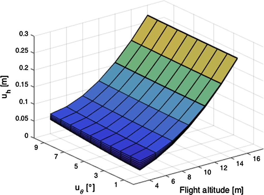
1st Workshop on Metrology for Agriculture and Forestry (METROAGRIFOR)                   IOP Publishing
IOP Conf. Series: Earth and Environmental Science 275 (2019) 012022 doi:10.1088/1755-1315/275/1/012022

Figure 1. Pre-programmed navigation trajectory for the soil assessment in the APM Planner
open-source software.

    Drone images and ground sensor data are so expected to play a crucial role in precision
agriculture, providing wide room for scientific research and development [4]. Furthermore,
several metrological aspects have to be considered for developing such platforms, from the sensors
embedded on them up to the instrumentation and the calibration procedures for their testing [5].
    Despite their effectiveness and usefulness, the main drawback lies on the fact that these
systems are calibrated only for a specific task (e.g., classifying different kinds of vegetation,
water bodies, urban, bare soil, etc.), without the ability of creating a holistic view of agricultural
processes. This lack of interoperability causes additional work for the human operators, since
they have to manually feed the output data from one system to another. For all such reasons,
software modules, drones and other equipment are object of research in order to develop a
common information middleware and application interface. The aim is to reduce monotonous
and time consuming work [6].
    In this paper, a review of the drone technology applied to the precision agriculture is
presented. In particular, the drone architecture according to the sensors embedded on the
payload for precision agriculture applications is reported. Then, the design of a drone in
terms of measurements capabilities, power consumption and time of flight according to the
application requirements is delineated. Emphasis is also placed in the control part of the drone,
understanding its dynamic behavior and how to control it. In such a way, changes in the
decision-making system and the mission planner can be made in a simpler way, facilitating the
development of different control strategies compared to those already available and validating the
effects of modifying the control architecture for complex missions. Finally, the main procedures
needed for the calibration of the sensors embedded on drones are reported and an overview
of the post-processing tools for extrapolating significant parameters of the monitored area are
described.
    The rest of the paper is organized as follows. An overview of the drone architectures and the
payload sensors for precision agriculture together with its flight control system are reported in
Sec. 2 and 3, respectively. Section 4 describes the use of drones for precise agriculture and, for
each application, a review of the needed calibration procedures is carried out. Moreover, the
main post-processing tools are described. Finally, Section 5 concludes the paper.

2. The architecture of a drone for precision agriculture
As reported in [7], the basic architecture of a drone, without considering the payload sensors,
consists of: (i) frame, (ii) brush-less motors, (iii) Electronic Speed Control (ESC) modules, (iv)
a control board, (v) an Inertial Navigation System (INS), and (vi) transmitter and receiver

                                                   2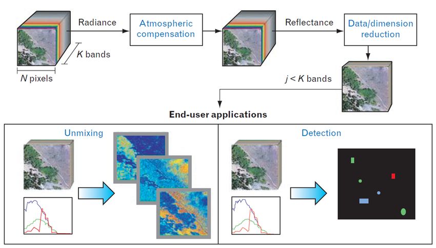
1st Workshop on Metrology for Agriculture and Forestry (METROAGRIFOR)                   IOP Publishing
IOP Conf. Series: Earth and Environmental Science 275 (2019) 012022 doi:10.1088/1755-1315/275/1/012022

                   Figure 2. Architectural overview of the Parrot Bluegrass.

modules.
   In precision agriculture, as well as in disaster relief, building inspection or traffic monitoring,
the employed drones are semi-autonomous. In that case, the drone has to fly according to the
definition of a flight path in terms of waypoints and flight altitude. Thus, the drone has to embed
on board a positioning measurement system (e.g., Global Navigation Satellite System, GNSS)
for knowing its position with respect to the waypoints. Furthermore, it embeds an altimeter
(e.g., barometer, laser altimeter, ultrasonic sensor) for flying at constant flight altitudes. An
example of software for defining the mission trajectory is the APM Planner [8]. In Fig. 1, the
user interface of this tool is depicted.
   The payload of a drone includes all the sensors and actuators that are not used for the
control of its flight (e.g., the gimbal with the RGB camera). In case of precision agriculture,
the sensors embedded on drones are: multispectral camera, thermal camera, RGB camera and
Light Detection and Ranging (LiDAR) systems.
   Multispectral cameras are used for quantifying the state of the monitored vegetation in terms
of: (i) chlorophyll content, (ii) leaf water content, (iii) ground cover and Leaf Area Index
(LAI), and (iv) the Normalized Difference Vegetation Index (NDVI). Thermal cameras have
demonstrated high potential for the detection of water stress in crops due to the increased
temperature of the stressed vegetation.
   For example, in [9], the authors propose a drone for vegetation monitoring using thermal and
multispectral cameras. The thermal camera is the thermovision A40M, with 320 × 240 pixels
and having a spectral response in the range of 7.5 µm to 13 µm. Furthermore, each pixel has a
resolution of 16 bits and a dynamic range of 233 K to 393 K. The multispectral sensor is the
six-band multispectral camera MCA-6 Tetracam. The camera consists of six independent image
sensors and optics with user configurable filters, having center wavelengths at 490, 550, 670,
700, 750, and 800 nm, respectively.
   RGB cameras and LiDAR systems are usually adopted to digitize the terrain surface to
provide the Digital Terrain Model (DTM) or the Digital Surface Model (DSM) of the monitored
area. The DSM represents the earth’s surface and includes all the objects on it. On the
other hand, the DTM represents the ground level of the soil without considering the vegetation
height. For example in [10], the authors use the Swinglet CAM drone with embedded the
compact camera Canon IXUS 220 HS for estimating the characteristics of a vineyard. They
have performed a flight by acquiring the images related to a vineyard in several waypoints.
By using the commercial tool Pix4Dmapper [11], the DSM and DTM are extrapolated. In
particular, the differential model of the vine rows is obtained by subtracting the DTM from the
DSM.
   According to the previous examples, in order to use a drone for precision agriculture, at least
the following capabilities are needed: (i) the drone has to fly according to waypoints definition,

                                                   3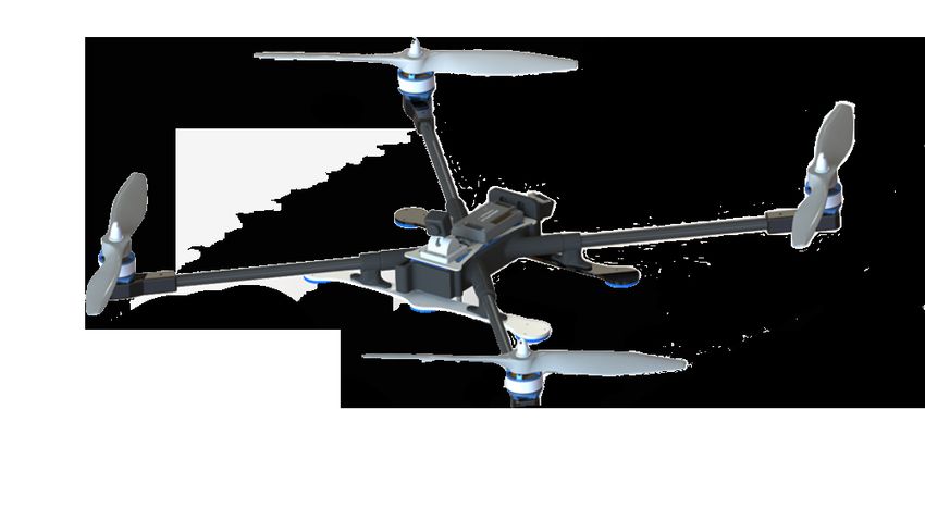
1st Workshop on Metrology for Agriculture and Forestry (METROAGRIFOR)                   IOP Publishing
IOP Conf. Series: Earth and Environmental Science 275 (2019) 012022 doi:10.1088/1755-1315/275/1/012022

                            xr , yr , zr , ψr
                                                Reference θc , φc On-board ω1 , ω2
                                                Generator Ωc , ψ̇c Control ω3 , ω4
                            xd , yd , zd , ψk
                                                  ud vd             pk qk
                                                                    rk

Figure 3. The control scheme. Subscript c indicates the commands, r indicates the references,
d indicates the drone variables and k indicates the sensors and data fusion outputs.

(ii) the drone has to control its flight altitude, (iii) the drone has to sense and avoid obstacles
during the flight, (iv) the drone has to land according to the state of the battery, automatically
and (v) the acquired images have to be stabilized with a gimbal.
    An example of drone that can be used for precision agriculture and fulfills the above mentioned
requirements is the Parrot Bluegrass (see, Fig. 2). In particular, it can be driven according to
preliminary defined waypoints and flight altitude values. Furthermore, it embeds a RGB camera,
the Parrot Sequoia multispectral sensor and a sensor for measuring the environmental luminosity.

3. Flight control system
As a common rule in the literature [12, 13], the flight control system of semi-autonomous drones
is split into two parts: a reference generator (outer loop), that takes into account the position to
reach, expressed in terms of waypoint (xr , yr and ψr ) and flight altitude (zr ), and generates the
command signals (ψ̇c , Ωc , θc and φc ); and an on-board control system (inner loop), that uses
such commands providing as output the motors speed ωi (i from 1 to the number of propellers).
They work together in a cascade control structure, where the inner loop (on-board) needs to
regulate at a rate faster than the outer loop (that usually runs on a ground control station).
Figures 3 and 5 describe the overall system and the on-board control architecture, respectively.
The reference generator uses the drone position (xd , yd and zd ) and the orientation along z-
axis (ψk ) to compute the command signals (ψ̇c , Ωc , θc and φc ), where the drone position and
velocity (ud , vd and wd ) come from the positioning measurement system. There are many
approaches to carry out the references, from basic heuristic techniques to more advanced model
based methods that exploit an accurate dynamical model of the plant. However also classical
(and simple) Proportional Integral Derivative (PID) controllers might benefit from a detailed
model. In any case, the dynamical model of the aircraft can be easily derived by introducing
the so-called inertial (OFI ) and body (OABC ) reference systems, as depicted in Fig. 4. Further
details can be found in [12, 13].
    The aim of the reference generator is to reach the position coordinates (xr , yr , zr and ψr )
by tuning the desired attitude (θc and φc ), the heading velocity (ψ̇c ) and the thrust (Ωc ) of
the drone, later used as references for the on-board control system. Usually, it is not much
complicated to design or modify the available control architecture. For example, in the case of
the Parrot Bluegrass, the Software Development Kit (SDK) can be employed to implement a
suitable position controller improving the performance of the existing one in the mission planner.
Also, the on-board control is decomposed into two parts: the attitude and the rate controller,
both illustrated in Fig. 5. The scheme integrates the state estimator that, starting from the
accelerometer and gyroscope data, allows to estimate the attitude (ψk , θk and φk ) and the
angular velocities (pk , qk and rk ) of the drone, used by the on-board control loop. Usually, such
control architecture is “closed”, especially when using commercial applications. Therefore, it
is not possible to make changes to either the control gains or the control loop (state estimator
included). Thus, those drawbacks and limitations have to be considered when going to design
a flight control system in a precision agriculture scenario. Disturbances rejection in adverse

                                                          4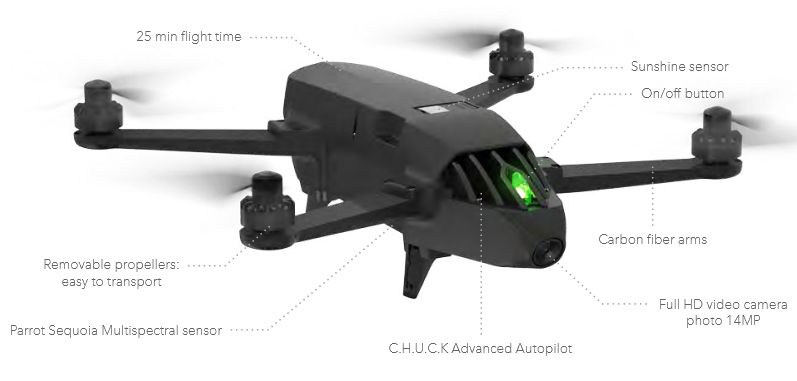
1st Workshop on Metrology for Agriculture and Forestry (METROAGRIFOR)                   IOP Publishing
IOP Conf. Series: Earth and Environmental Science 275 (2019) 012022 doi:10.1088/1755-1315/275/1/012022

                                                                                 ez
                                                                             ψ
                                                                         ω2
                                                                                                 ω3
                                                        ω1
                                                                                 OABC

                                                                                      ω4        θ
                                                                                               ey
                                                                         φ
                                                              ex
                                                 Z

                             X                         OF I

                                                        Y

Figure 4. Drone in the body-frame (OABC ) and the fixed-frame (OFI ) reference system. The
forces, the spin direction and the propellers velocity, ωi , from each rotor are also reported.

                                                              ψ̇c                               Ωc

                                                                +
                         θ c , φc +         Attitude      pc +          Rate PID            Actuators
                                    −         PID         qc −          Controller          (motors)
                                 θk φ k                     p k qk
                                                             rk
                                          Sensor Fusion                                     Gyroscope

                                                                                           Accelerometer

                                                                                             Aircraft

Figure 5. On-board control architecture of a semi-autonomous drone. Usually, the attitude
controller runs at 250 Hz while the rate controller runs at 500 Hz.

weather conditions and robustness against model uncertainties are a key feature. Indeed, the
aircraft has to be able to control its position under the influence of wind gusts. This is especially
true when flying close to obstacles (e.g., threes or vineyards), since position errors due to a wind
gust might cause a collision damaging the crops. Current position control methods, such as PID,
do not perform well under the influence of gusts. Indeed, PID gust rejection properties scale with
magnitudes of the gains, which is often limited by the positioning measurement system update
frequency in outdoor scenarios. Moreover, the integrator term is generally slow in compensating
persistent wind disturbances. Nowadays, there is much activity of the scientific research in this
specific field [14, 15].

                                                                    5
1st Workshop on Metrology for Agriculture and Forestry (METROAGRIFOR) IOP Publishing
IOP Conf. Series: Earth and Environmental Science 275 (2019) 012022 doi:10.1088/1755-1315/275/1/012022
Figure 6. The post processing procedure for extrapolating information related to the state of
the vegetation from the acquired multispectral images.
Figure 7. The monitoring operations of a crop by means of multispectral camera embedded on
drone.
4. The use of drone for precision agriculture
Intensive agriculture has several negative impacts on the environment. It adds significant and
environmentally detrimental amounts of nitrogen and phosphorus to terrestrial ecosystems [16].
Also, excessive fertilizers application can cause pollution risks for the environment, whereas
insufficient fertilizer used to replace nitrogen and phosphorus lost through intensive cropping
can lead to soil degradation and loss of fertility. Additionally, pollution of water courses and
bodies, and consequent degradation of water-related ecosystems are rising due to agricultural
chemicals seeping into nearby water. Furthermore, serious soil degradation, which threatens the
productivity of the different soils, can be observed all over Europe [17].
61st Workshop on Metrology for Agriculture and Forestry (METROAGRIFOR) IOP Publishing
IOP Conf. Series: Earth and Environmental Science 275 (2019) 012022 doi:10.1088/1755-1315/275/1/012022
Figure 8. The 3D reconstruction process by considering two images acquired by drone in two
waypoints [22].
In addition to the environmental impact, the health risk aspect of the use of chemicals in
agriculture needs to be considered. Indeed, chemicals may threat farm workers, as well as
families and possibly the inhabitants of the areas surrounding crops, vineyards and farming
sites. Additionally, pesticides are absorbed by crop and natural resources (i.e., water and soil)
and end up as concealed substances in the food chain, with the increasing risk for both livestock
and humans, with huge negative impacts on the public health. Through autonomous precision
farming, these effects can be mitigated since chemicals, such as fertilizer and pesticides, are only
administered where needed instead of being applied over a large area.
In such a context, the use of drones in agriculture has recently been introduced for big areas
inspection and smart targeted irrigation and fertilization [18, 19]. The possibility of detecting, by
a drone and an infrared camera, the areas where a major irrigation is needed or where a foliage
disease is spreading, can help agronomists to save time, water resources and reduce agrochemical
products. At the same time, such advanced farming techniques may lead to increased crop
productivity and quality.
Specifically, water deficiency, nutrient stress or diseases can be localized and measured and
decision can be made to fix the problem. Many vegetation indexes have been developed which
involve various data features, such as the NDVI. Special camera systems are able to acquire data
from an invisible part of the electromagnetic spectrum called Near-Infraed (NIR) and extract
quality information, such as the presence of algae in the rivers or oil spills near costs [20].
Current agriculture drones applications [21] are: (i) biomasses, crop growth and food quality
monitoring, (ii) precision farming, such as to determine the degree of weeds for site-specific
herbicide applications, (iii) harvesting and logistic optimization. All these applications require
the processing of the images acquired from a camera embedded on the drone.
According to the sensors embedded on drones, it is possible to define three types of
applications for precision agriculture: (i) applications based on multispectral and thermal
cameras, and (ii) applications based on RGB cameras.
71st Workshop on Metrology for Agriculture and Forestry (METROAGRIFOR) IOP Publishing
IOP Conf. Series: Earth and Environmental Science 275 (2019) 012022 doi:10.1088/1755-1315/275/1/012022
Figure 9. Height uncertainty value uh vs flight altitude and pitch angle uncertainty value uθ ,
for different uncertainty values related to the measurement of the distance between the two
waypoints [22].
4.1. Applications based on multispectral and thermal cameras
Usually, for agriculture the terrain is scanned by using satellites with multispectral and thermal
cameras. For precision agriculture, due to the needed high spatial resolution, drones are more
suitable platforms than satellites for scanning. They offer much greater flexibility in mission
planning than satellites.
The drone multispectral and thermal sensors simultaneously sample spectral wavebands
over a large area in a ground-based scene (see, Fig. 7). After post-processing, each pixel in
the resulting image contains a sampled spectral measurement of the reflectance, which can
be interpreted to identify the material present in the scene. In precision agriculture, from
the reflectance measurements, it is possible to quantify the chlorophyll absorption, pesticides
absorption, water deficiency, nutrient stress or diseases.
There are four sampling operations involved in the collection of spectral image data: spatial,
spectral, radiometric, and temporal. The spatial sampling corresponds to the Ground Sample
Distance (GSD). The GSD is the distance in meters between two consecutive pixel centers
measured on the ground. It depends on the sensor aperture and the flight altitude. The spectral
sampling is performed by decomposing the radiance received in each spatial pixel into a finite
number of wavebands. The radiometric resolution corresponds to the resolution of the Analog
to Digital Converter (ADC) used for sampling the radiance measured in each spectral channel.
Furthermore, the temporal sampling refers to the process of collecting multiple spectral images
of the same scene in different instants.
Those four sampling operations have to be taken into account for the design of a flight
mission and for choosing correctly the multispectral camera and the drone platform. The post-
processing procedure required for extrapolating information from the acquired multispectral
and thermal images is depicted in Fig. 6. In particular, the images acquired by drone provides
measurements related to the radiance in each pixel. In order to measure the reflectance, image
processing algorithm are applied to compensate the effects due to the atmosphere absorption
and the spectrum of the solar illumination. From the reflectance values, it is possible to detect
several materials and the state of the vegetation according to known spectral responses.
81st Workshop on Metrology for Agriculture and Forestry (METROAGRIFOR) IOP Publishing
IOP Conf. Series: Earth and Environmental Science 275 (2019) 012022 doi:10.1088/1755-1315/275/1/012022
4.2. Applications based on RGB cameras
In precision agriculture, the images acquired by drones embedding RGB cameras are used for
extrapolating DTM and DSM related to the surveyed area. To this aim, it is important to
define the flight mission parameters according to the spatial resolution, and the measurement
accuracy of the reconstructed DTM and DSM. As in case of multispectral and thermal cameras,
the spatial resolution is defined in terms of GSD. According to the GSD that would be reached,
the camera resolution and the flight altitude are chosen. The height measurements of the terrain
and of the objects in the scene are obtained by taking two consecutive images from the camera
in two different waypoints [22]. The two images have to overlap the same objects in scene (see,
Fig. 8). Usually, an overlapping factor of the 70 % between the two images is adopted. From
the two acquired images, by knowing the camera parameters, the position and the altitude of
the waypoints, it is possible to extrapolate the heights of the objects in the scene.
In [22], the authors propose an uncertainty model for quantifying the accuracy related to the
3D reconstruction of a terrain or a surface by means of aerial photogrammetry. As reported
in Fig. 9, they have modeled the uncertainty related to the height measurements for several
flight altitudes according to the uncertainty on the measurements of the distance between two
waypoints and the orientation of the second waypoint respect to the first one.
From that figure, it is possible to observe that the uncertainty on the height measurements
at a flight altitude of 16 m is in the order of 30 cm. Furthermore, they have evaluated the
uncertainty related to the commercial tool, Pix4Dmapper [11], adopted to provide DTM and
DSM. In that case, at the flight altitude of 11 m, the measurement uncertainty is 30 cm.
From those analyses, it is highlighted that the accuracy related to a 3D reconstruction mainly
depends on the accuracy of the drone position measurement system. Thus, according to the
target accuracy, several techniques for localizing the drone during the flight can be adopted: (i)
differential GPS systems, having a position accuracy in the order of 1 m, (ii) real-time kinematic
(RTK) GPS, having an accuracy in the order of 2 cm, and (iii) simultaneous localization and
mapping (SLAM) based techniques achieving a position accuracy in the order of 10 cm.
5. Conclusions
In this paper, a review on the use of drones for precision agriculture has been presented. In
particular, the general architecture of a drone for multispectral/thermal sensing and DTM/DSM
has been discussed. Some technical details about the control system architecture have been also
provided. Furthermore, for both the applications, the main limitations and the parameters to
take into account before performing a flight are described.
Future trends in this research field go toward the use of cheap commercial mini or micro
drones. However, in doing so, the measurement accuracy specifications are challenging to be
addressed and several problems arise. For example, for that drones the wind influence, the low
GPS accuracy and the strong drift of the INS play destructing effects in flight stability and
image acquisition [23].
6. Acknowledgements
This work was partially funded by European Commission H2020 Framework Program under
Grant No. 783221 - AFarCloud project - “Aggregate Farming in the Cloud”.
References
[1] Gnip P, Charvat K and Krocan M 2008 Analysis of external drivers for agriculture World conference on
agricultural information and IT, LAAID AFITA WCCA 797–801
[2] Carpenter S R, Caraco N F, Correll D L, Howarth R W, Sharpley A N and Smith V H 1998 Nonpoint
pollution of surface waters with phosphorus and nitrogen Ecological Applications 8 559–568
[3] Reinecke M and Prinsloo T 2017 The influence of drone monitoring on crop health and harvest size 2017 1st
International Conference on Next Generation Computing Applications pp 5–10
91st Workshop on Metrology for Agriculture and Forestry (METROAGRIFOR) IOP Publishing
IOP Conf. Series: Earth and Environmental Science 275 (2019) 012022 doi:10.1088/1755-1315/275/1/012022
[4] Murugan D, Garg A, Ahmed T and Singh D 2016 Fusion of drone and satellite data for precision agriculture
monitoring 2016 11th International Conference on Industrial and Information Systems pp 910–914
[5] Daponte P and Debei S 2018 Special issue on selected methods and instrumentation of metrology for aerospace
IEEE Aerospace and Electronic Systems magazine 33
[6] Fontanella R, Vetrella A R, Fasano G, Accardo D, Moriello R S L, Angrisani L and Girard R 2017 A
standardized approach to derive system specifications for drones operating in the future UTM scenario
2017 5th IEEE International Conference on Models and Technologies for Intelligent Transportation Systems
pp 250–255
[7] Brzozowski B, Daponte P, De Vito L, Lamonaca F, Picariello F, Pompetti M, Tudosa I and Wojtowicz K
2018 A remote-controlled platform for UAS testing IEEE Aerospace and Electronic Systems Magazine 33
48–56
[8] APM planner official web site http://ardupilot.org/planner/ accessed: Sept. 2018
[9] Berni J A J, Zarco-Tejada P J, Suarez L and Fereres E 2009 Thermal and narrowband multispectral remote
sensing for vegetation monitoring from an Unmanned Aerial Vehicle IEEE Transaction On Geoscience
and Remote Sensing 47 722–738
[10] Burgos S, Mota M, Noll D and Cannelle B 2015 Use of very high-resolution airborne images to analyse 3D
canopy architecture of a vineyard The International Archives of the Photogrammetry, Remote Sensing and
Spatial Information Sciences pp 399–403
[11] Pix4Dmapper official web site https://pix4d.com/ accessed: Sept. 2018
[12] Bouabdallah S, Murrieri P and Siegwart R 2005 Towards autonomous indoor micro VTOL Autonomous
Robots 18 171–183
[13] Silano G, Aucone E and Iannelli L 2018 CrazyS: A software-in-the-loop platform for the Crazyflie 2.0 nano-
quadcopter 2018 26th Mediterranean Conference on Control and Automation pp 352–357
[14] Smeur E J J, de Croon G and Chu Q 2018 Cascaded incremental nonlinear dynamic inversion for mav
disturbance rejection Control Engineering Practice 73 79–90
[15] Oleynikova H, Taylor Z, Siegwart R and Nieto J 2018 Safe local exploration for replanning in cluttered
unknown environments for microaerial vehicles IEEE Robotics and Automation Letters 3 1474–1481
[16] Vitousek P M, Mooney H A, Lubchenco J and Melillo J M 1997 Human Domination of Earth’s Ecosystems
Science 277 494–499
[17] Salmelin J, Pölönen I, Puupponen H H, Hämäläinen H, Karjalainen A K, Väisänen A and Vuori K M 2018
Hyperspectral imaging of macroinvertebrates—a pilot study for detecting metal contamination in aquatic
ecosystems Water, Air, & Soil Pollution 229 308
[18] Bacco M, Ferro E and Gotta A 2014 UAVs in WSNs for agricultural applications: An analysis of the two-ray
radio propagation model 2014 IEEE SENSORS pp 130–133
[19] Gago J, Douthe C, Coopman R, Gallego P, Ribas-Carbo M, Flexas J, Escalona J and Medrano H 2015 UAVs
challenge to assess water stress for sustainable agriculture Agricultural Water Management 153 9–19
[20] Manfredonia I, Stallo C, Ruggieri M, Massari G and Barbante S 2015 An early-warning aerospace system
for relevant water bodies monitoring 2015 IEEE Metrology for Aerospace pp 536–540
[21] Grenzdörffer G, Engelb A and Teichertc B 2008 The photogrammetric potential of low-cost UAVs in forestry
and agriculture The International Archives of the Photogrammetry Remote Sensing and Spatial Information
Sciences vol 37 pp 1207–1214
[22] Daponte P, De Vito L, Mazzilli G, Picariello F and Rapuano S 2017 A height measurement uncertainty
model for archaeological surveys by aerial photogrammetry Measurement 98 192–198
[23] Daponte P, De Vito L, Mazzilli G, Picariello F, Rapuano S and Riccio M 2015 Metrology for drone and
drone for metrology: Measurement systems on small civilian drones 2015 IEEE Metrology for Aerospace
pp 306–311
10You can also read