A Seriously Smart Path to Happiness - Trimble Geospatial
←
→
Page content transcription
If your browser does not render page correctly, please read the page content below
CUSTOMER EXPERIENCE I SEPTEMBER 2020
A Seriously Smart Path
to Happiness
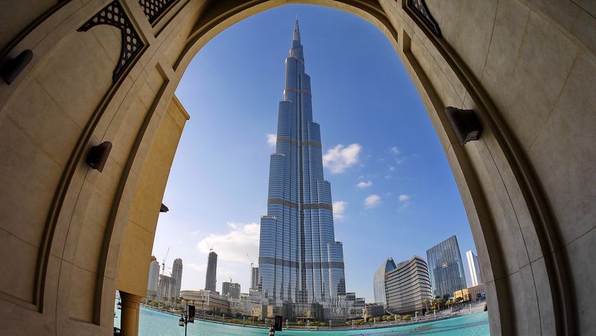
The most iconic building in Dubai: the Burj Khalifa is the world’s tallest building at a height of 828 meters and 160 stories.
Photo: Hans-Jürgen Schmidt, Pixabay
Mobile mapping helps drive Dubai’s
Solution
Smart City strategy
Trimble® MX9 Mobile Mapping Solution
3D imaging brings speed, precision and safety Trimble Business Center Software
to Dubai’s streets Applanix® POSPac MMS™ Software
TRANSFORMING THE WAY THE WORLD WORKS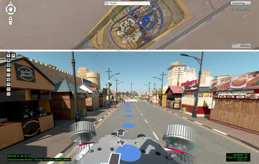
overview
In 2013, Dubai launched a Smart Dubai
program with the aim of becoming the
smartest and happiest city on earth. At
the heart of these initiatives has been
geospatial data. To provide the mapping
                                                                                          Location
precision and speed needed for the                                                      DUBAI. UAE

program and city’s growth, the GIS
Center acquired a 3D mobile mapping
solution. The new system has not only
enabled the group to map Dubai in record
time, it’s helping them build the smartest
and happiest city.

A significant part of Smart Dubai has been GeoDubai, a
                                                            DUBAI IN 3D
comprehensive scheme managed by Dubai Municipality’s
GIS Center to collect and provide all geospatial data and
related services across the entire UAE.                     To provide geospatial referencing to the MX9 system, the
                                                            Dubai Municipality Survey Department has a network of
Although the GIS Center has been collecting and             roughly 12,000 existing ground control points (GCPs)
processing geospatial data of the entire Dubai emirate      to provide centimeter-accuracy control for the mobile
since 2001, keeping pace with its ever-changing city has    mapping. The department also has a network of Virtual
been challenging. The department needed a mapping           Reference Stations (VRS) to support RINEX post-
system that would allow them to safely and precisely        processing for the MX9’s GNSS.
capture Dubai’s infrastructure as it changes.
                                                            With the MX9 mounted on their SUV, a two-person crew
In late 2018, the GIS Center acquired the Trimble MX9       scanned any visible feature within 400 m of the road
mobile mapping solution, a vehicle-mounted 3D mapping       while driving 80 km/hr. On average it took the team two
system that captures centimeter-grade spatial data at       to three hours to acquire 100 km of data per day on both
highway speeds without sacrificing data quality or crew     sides of the roads; by the end of April 2020, they had
safety. In mid-2019, the Center initiated its first major   captured all of Dubai’s major roadways, landmarks and
mobile-mapping project: imaging and scanning the            buildings in 3D.
emirate’s roads and urban infrastructure.

  TRANSFORMING THE WAY THE WORLD WORKS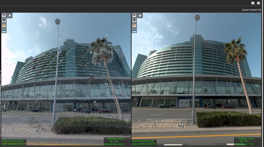
Paul Reichardt, PLS, measures one of the ground control targets
                                                                           with a Trimble R8 GNSS receiver

The MX9 captures images as it drives the streets of Dubai’s Global Village. The view at the top indicates the vehicle location.

“A surveyor using conventional technology would likely need
nearly two months to cover the same amount of distance
we collect in one day,” said Maryam Obaid Almheiri, the GIS
Center’s Director. “We get 360-degree panoramas every five
seconds and two million 3D points per second of everything
that’s there. There’s no comparison.”

After each data acquisition run, a team used a suite
of Trimble software tools to process the data. Once
the MX9’s GNSS and inertial data were processed
with POSPac, the Trimble Business Center software
integrated the trajectory information and the control
point measurements to geo-reference the data collected
from the MX9 cameras and scanners. After processing                        Thanks to the MX9’s overhead reach of up to 400 m high, crews can
                                                                           capture nearly all of Dubai’s tallest buildings.
and colorizing each point cloud, they extracted a host
of features such as road furniture, signs, houses and
building outlines to produce vectorized maps for GIS-
based analyses.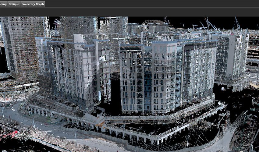
The street view, panoramic images, point clouds
and base maps were published on the GIS Center’s
GeoDubai advanced geospatial portal, giving public
and private end users the ability to view, measure and
study any feature or structure in the city. Last June,
the 3D mobile mapping data was integrated with the
GIS Center’s latest smart innovation: Dubai Here, a
Web browser system that offers access to geospatial
data including maps of Dubai’s landmarks, commercial
and residential structures, parks, trees, bridges,
tunnels and transit network.

Based on their initial 3D mapping success, the GIS
Center is confident the MX9 system will steer them in
the right direction towards building the smartest and
happiest city.

Top right: Dubai’s Festival City, captured simultaneously by
the MX9’s laser scanners and cameras. The MX9 acquired
360-degree panorama images every five seconds and two million
3D points per second.

Bottpm right: A point cloud view of Dubai’s Exhibition Center,
which will host the world EXPO 2020

“What makes the mobile mapping data so effective is that no explanation is
needed. Unlike with a singular GNSS survey point, with the MX9 street views,
users can see the whole city in front of them. It’s so much easier to use.”

                                   — Maryam Obaid Almheiri, GIS Center Director, Dubai Municipality

                                                                                                                  NORTH AMERICA          EUROPE                  ASIA-PACIFIC
                                                                                                                  Trimble Inc.           Trimble Germany GmbH    Trimble Navigation
                                                                                                                  10368 Westmoor Drive   Am Prime Parc 11        Singapore PTE Limited
                                                                                                                  Westminster CO 80021   65479 Raunheim          3 HarbourFront Place
                                                                                                                  USA                    GERMANY                 #13-02 HarbourFront Tower Two
                                                                                                                                         +49-6142-2100-0 Phone   Singapore 099254
                                                                                                                                         +49-6142-2100-140 Fax   SINGAPORE
  Contact your local Trimble Authorized Distribution Partner for more information                                                                                +65-6871-5878 Phone
                                                                                                                                                                 +65-6871-5879 Fax
© 2020, Trimble Inc. All rights reserved. Trimble and the Globe & Triangle logo are trademarks of Trimble Inc.,
registered in the United States and in other countries. Applanix and POSPac are trademarks of Trimble Inc. All
other trademarks are the property of their respective owners. PN 022516-540 (09/20)

TRANSFORMING THE WAY THE WORLD WORKS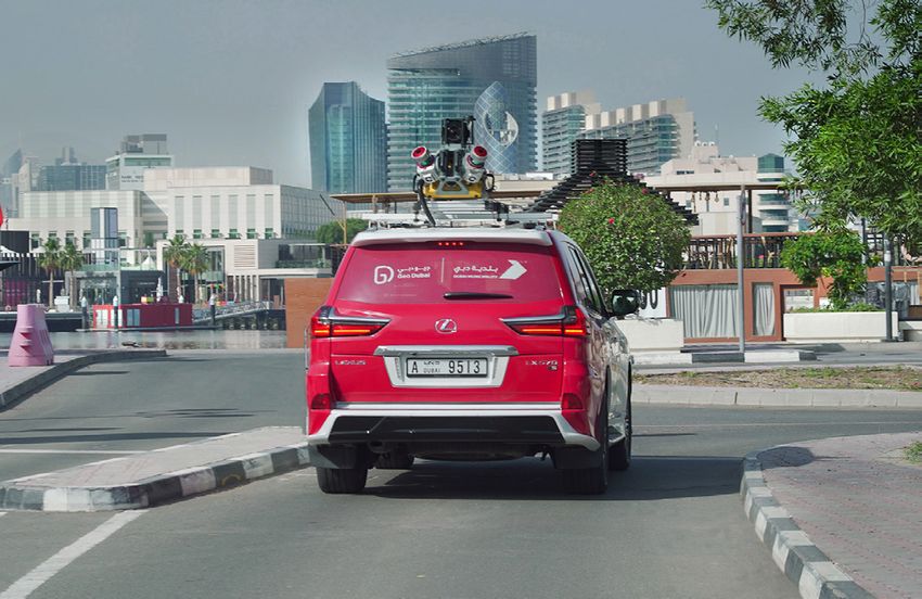
You can also read