Accommodation space indicates dune development potential along an urbanized and frequently nourished coastline - Earth Surface Dynamics
←
→
Page content transcription
If your browser does not render page correctly, please read the page content below
Earth Surf. Dynam., 7, 129–145, 2019
https://doi.org/10.5194/esurf-7-129-2019
© Author(s) 2019. This work is distributed under
the Creative Commons Attribution 4.0 License.

            Accommodation space indicates dune development
                  potential along an urbanized and
                   frequently nourished coastline
                                          Corjan Nolet and Michel J. P. M. Riksen
                      Soil Physics and Land Management Group, Wageningen University, P.O. Box 47,
                                          6700 AA Wageningen, the Netherlands
                                  Correspondence: Corjan Nolet (corjan.nolet@gmail.com)

                                     Received: 26 April 2018 – Discussion started: 14 May 2018
                       Revised: 11 December 2018 – Accepted: 12 December 2018 – Published: 29 January 2019

       Abstract. With densely populated areas well below mean sea level, the Netherlands relies heavily on its dunes
       to ensure coastal safety. About half of the sandy coastline, however, is subject to structural marine erosion and
       requires frequent sand nourishment as a counteractive measure. A key component of present-day coastal safety
       policy is creating favorable conditions for natural dune development. These conditions essentially involve (1) a
       steady supply of wind-blown sand towards (2) a wide accommodation space where sand can accumulate and
       dunes are sheltered from frequent storm surge impacts. This paper examines to what extent an experimental
       mega-scale beach nourishment (termed Zandmotor in Dutch) has contributed to creating accommodation space
       favorable for dune development. Using publicly available airborne lidar data and Sentinel-2 satellite imagery,
       favorable accommodation space is identified by comparing recent changes in coastal morphology against dune
       vegetation-cover dynamics. With a focus on European marram grass (Ammophila arenaria) as the most promi-
       nent dune-building species, this paper demonstrates that the Zandmotor supports an especially high potential
       for incipient (embryo) dunes to develop as most of its favorable accommodation space is located on the beach.
       However, considering the conditions required for successful marram grass establishment as well as persistent
       anthropogenic disturbances arising from recreation and nature management practices, it is not likely that dune
       development along this urbanized coastline reaches its full potential.

1   Introduction                                                   they are so strongly modified by human intervention that
                                                                   they too could be considered a feat of hydraulic engineering
Vegetated coastal foredunes, the most seaward facing dune          (De Vriend et al., 2015).
ridge parallel to the coastline, often form the first and fore-       The focus of Dutch coastal policy has traditionally been on
most line of flood defense against the sea (Hardisty, 1994).       safety from flooding, which was guaranteed by large struc-
This is certainly true for the Netherlands, a country where the    tures such as sea dikes, groins and other artificial barriers.
most densely populated areas are situated well below mean          Nowadays, however, the focus has widened to also include
sea level. And, although widely known for its hydraulic engi-      preserving the spatial quality and natural values of the coastal
neering structures, over 75 % of the Dutch coastline relies on     zone (Van Slobbe et al., 2013). It was recognized that coastal
its foredunes to ensure coastal safety (Van Koningsveld and        dunes, apart from flood defense, also represent unique eco-
Mulder, 2004). About half of that sandy coastline, however,        logical and recreational values and often serve as an impor-
is subject to structural marine erosion and requires frequent      tant source for drinking water supply (e.g., De Jong et al.,
nourishment of dredged-up sand as a counteractive measure          2014; Keijsers et al., 2015b). By acknowledging sand as “the
(Van der Wal, 2004). Subsequently, while the foredunes in          carrier of all coastal functions” the principal management
the Netherlands are considered natural landscape elements,         practice since 1990 has been to nourish the coastline with

Published by Copernicus Publications on behalf of the European Geosciences Union.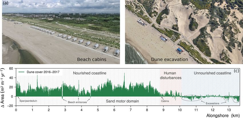
130                                        C. Nolet and M. J. P. M. Riksen: Accommodation space indicates dune potential

sand whenever it was about to retreat beyond a defined ref-      self on the beach through dispersal of seeds and rhizome
erence position (Van Koningsveld et al., 2007). A key com-       fragments by wind and water (Konlechner and Hilton, 2009;
ponent of such a dynamic preservation of the coastline in-       Hilton and Konlechner, 2011). Over time, and under the right
volves utilizing natural processes to further redistribute the   conditions, these individual embryo dunes can merge into
sand. By allowing marine and aeolian forces to gradually         continuous and shore-parallel foredune ridges that extend in
help shape the coastline, the aim of this building-with-nature   a seaward direction (Hardisty, 1994; Hesp, 1989, 2002).
engineering strategy is to counteract a negative sediment bal-       Creating favorable conditions for dune development is an
ance while minimizing adverse effects to the coastal ecosys-     important goal for the Zandmotor (Dutch for “sand motor”,
tem (Van Slobbe et al., 2013).                                   see Fig. 1), an unprecedented mega-scale beach nourish-
   An essential element to building with nature in the Nether-   ment of 21.5 Mm3 constructed in 2011 just south of The
lands is the utilization of European marram grass (Am-           Hague (Stive et al., 2013). The overall purpose of this mega-
mophila arenaria) to help stabilize and build up the fore-       nourishment experiment is to test whether its benefits in
dunes (Keijsers et al., 2015b). Compared to other (native)       terms if coastal safety, spatial quality and natural values out-
coastal pioneer psammophytes that thrive on sandy soils,         weigh the extra costs involved and to determine to what ex-
this beach grass is most effective at dune building because      tent such an approach can help cope with expected changes
not only can it trap high amounts of wind-blown sand in its      in the global climate (e.g., Mulder and Tonnon, 2011; Stive
leaves and roots, but it will in fact grow much more vigor-      et al., 2013; De Schipper et al., 2016). In line with the
ously because of regular burial in sand (e.g., Disraeli, 1984;   building-with-nature approach, natural dynamics are encour-
Van der Putten et al., 1988; Hesp, 1991; Nolet et al., 2017).    aged to redistribute the sand of the Zandmotor along the
This introduces a reinforcing feedback crucial to coastal dune   coastline, thereby broadening the adjacent foredunes and
development: trapping of wind-blown sand encourages mar-         beach. Specifically, the main objective of the project was
ram grass to grow, which in turn enhances the capacity of        defined as “Encouraging natural dune growth, primarily in
marram grass to trap sand and build dunes (Maun, 1998;           width, in the coastal cell between the cities Rotterdam and
Zarnetske et al., 2012). This trait, combined with the abil-     The Hague. This creates a larger sand buffer to cope with ris-
ity of clonal growth through rhizome fragments (Konlech-         ing sea level as well as more space for nature and recreation
ner et al., 2013), enables marram grass to help create and       and a larger freshwater lens under the dunes” (Fiselier, 2010;
maintain high vegetated foredunes critical to coastal safety     Van Slobbe et al., 2013).
(Ranwell, 1972; Keijsers et al., 2015b). Moreover, because           However, while the Delfland coast partly maintains rela-
the Dutch shoreline is frequently nourished with dredged-up      tively wide and natural dune areas, the aerial photos in Fig. 1
sand, positive plant–sand feedback dynamics enable the ad-       clearly show that in some places the dunes are not more
jacent foredunes to grow in pace with sea-level rise due to      than a narrow foredune ridge that is directly bordered by
changes in the global climate (Temmerman et al., 2013).          urban areas. Because the region is densely populated, the
   For that reason, present-day Dutch coastal safety policy in   coastline (including the Zandmotor) faces persistent pressure
particular prioritizes creating favorable conditions for natu-   from anthropogenic disturbances. Even though the Delfland
ral dune development. These conditions, essentially, involve     coast is meant to serve a wide range of socioeconomic func-
(1) a steady supply of wind-blown sand towards (2) a wide        tions related to recreation and leisure, activities arising from
accommodation space (Jervey, 1988) where sand has the            these function are often in direct conflict with the objec-
potential to accumulate and developing dunes are sheltered       tives related to coastal safety and natural values (e.g., Jack-
from frequent storm surge impacts (e.g., Ruggiero et al.,        son and Nordstrom, 2011; Lithgow et al., 2013). Within this
2001; Claudino-Sales et al., 2008; Montreuil et al., 2013;       context, this paper examines to what extent the Zandmo-
Van Puijenbroek et al., 2017a). Although a predominantly         tor has contributed to creating accommodation space favor-
landward wind regime is required, the morphology of the          able for dune development, i.e., accommodation space that
beach arguably exerts the largest control on foredune de-        is sheltered from frequent storm impacts and experiencing
velopment conditions (Short and Hesp, 1982). Aeolian sand        a steady accumulation of wind-blown sand. This favorable
supply, for example, is typically highest on gently sloping      accommodation space is identified, using publicly available
(i.e., dissipative) beaches, where wide intertidal areas store   remote-sensing data, by (1) comparing the presence of exist-
large volumes of sand that are well sorted by wave ac-           ing dunes against recent morphology of the Delfland coast
tion (e.g., Hesp, 1989; Anthony, 2013). Wide accommoda-          and by (2) comparing recent coastal morphological changes
tion space for foredune development is subsequently pro-         against changes in dune cover by marram grass. Then, by
vided when such a dissipative coastline is supported by a        taking into account the existing dunes and the conditions re-
wide supratidal beach that is high enough to offer protection    quired for successful marram grass establishment, the iden-
from frequent storm surge impacts (e.g., Sallenger Jr., 2000;    tified favorable accommodation space is used to indicate the
Suanez et al., 2012; Houser et al., 2008). Foredune devel-       full potential for dune development along this urbanized and
opment is initiated when discrete clumps of incipient dunes      frequently nourished coastline.
(i.e., embryo dunes) form after marram grass establishes it-

Earth Surf. Dynam., 7, 129–145, 2019                                                 www.earth-surf-dynam.net/7/129/2019/
C. Nolet and M. J. P. M. Riksen: Accommodation space indicates dune potential                                                131

2     Materials and methods                                        is the locally very high construction height. Most of the base
                                                                   is constructed at a height of around 5 m a.m.s.l., while just
2.1    Regional setting                                            north of a small dune lake the Zandmotor reaches a height of
                                                                   7 m a.m.s.l. This is well above the current maximum storm
The Zandmotor is located along the Delfland coast, an ap-          surge level of about 3 m a.m.s.l., so reworking of sand on
proximately 15 km long stretch of coastline that runs between      the Zandmotor is almost exclusively due to aeolian forcing
Rotterdam and The Hague parallel to the dominant south-            (Hoonhout and De Vries, 2017). As a consequence, while
western wind direction. The Delfland coast has a long his-         beneficial to already established dunes, Puijenbroek (2017)
tory of coastal erosion: early 17th century maps make it clear     concluded that this high construction height may also impede
that the coastline, compared with today, experienced a sig-        the establishment of new embryo dunes as rhizome dispersal
nificant (> 1.5 km) landward retreat (Van der Meulen et al.,       by tide and wave action is absent on parts of the Zandmotor.
2014). In the late 19th century the Delfland coast was forti-      The semidiurnal tidal dynamics along the Delfland coast are
fied by groynes, but that only slowed down coastal erosion to      characterized by a spring (neap) tidal amplitude around 2.0 m
a landward retreat of about 1 m yr−1 on average. Therefore         (1.5 m), generating alongshore currents with a velocity of up
from the early 1980s onward, well before it became central         to 0.5 ms−1 (Luijendijk et al., 2017).
policy, the Delfland coast has been frequently replenished
with sand nourishment of varying volumes (Van Koningsveld          2.2     Vegetated coastal dune dynamics
et al., 2007). Still, in 2002 the Delfland coast was labeled a
“weak link” as it did not meet stricter coastal safety standards   Data on the presence of dunes along the Delfland coast and
that reflected expected increases in storm surge frequency         changes in dune cover by marram grass were obtained using
and magnitude due to climate change (Keijsers et al., 2015b).      Sentinel-2A multispectral satellite imagery provided by the
Between 2009 and 2011, to guarantee that the Delfland coast        European Space Agency (ESA). Sentinel-2 images are ac-
could withstand hydraulic boundary conditions with a recur-        quired in 13 spectral bands in the visible (VIS), near-infrared
rence period of once every 10 000 years, most of the existing      (NIR) and shortwave infrared (SWIR) spectral ranges. Two
foredunes were broadened in a seaward direction (up to about       level-1C images were downloaded from the Copernicus
100 m) with a sand nourishment of approximately 20 Mm3             open-access hub (https://scihub.copernicus.eu, last access:
over a length of 12 km. This included construction of a new        11 January 2018), with acquisition dates in the autumn of
dune area in the south (called Spanjaardsduin in Dutch) to         2016 (11 September) and 2017 (12 October), when above-
compensate for loss of natural values because of expansion         ground biomass of marram grass is highest (Nolet et al.,
of the Rotterdam harbor (Van der Meulen et al., 2014). Af-         2017). With applied radiometric calibration and geometric
ter completion, the newly created foredune ridge ranged be-        correction, level 1C images contain top of atmosphere (TOA)
tween 4 and 12 m above mean sea level (a.m.s.l.) from toe          reflectance in cartographic geometry (Drusch et al., 2012).
to crest. For stabilization, the approximately 15◦ stoss slope     Out of the 13 available bands, the 4 bands with the highest
was manually planted with shoots of marram grass in a reg-         spatial resolution (10 m pixel size) were selected for further
ular pattern of about 7–9 small tussocks per square meter.         analysis. Table 1 lists the characteristics of the bands, which
About 75 % of the Delfland coastline has been reinforced in        are in the visible (blue, green, red) and near-infrared part
this manner between 2009 and 2011. The newly created fore-         of the spectrum. To illustrate the Sentinel-2 imagery used
dune ridge stretches landward approximately until the paved        for analysis, Fig. 2 shows an image of the Zandmotor indi-
bike path (gray line in Fig. 1) that runs along its crest.         cating the Normalized Difference Vegetation Index (NDVI;
   Once the new safety standards were met, the Delfland            Rouse Jr. et al., 1974; Tucker, 1979). This ratio takes ad-
coast was considered an appropriate location to conduct the        vantage of the contrasting reflection of photosynthetically ac-
Zandmotor mega-nourishment experiment. As can be seen in           tive vegetation at visible and near-infrared wavelengths and
Fig. 1, the Zandmotor has a hook-shaped design that aims to        is widely used for detection and classification of vegetated
mirror the natural onshore migration of an intertidal sandbar.     areas (e.g., Pettorelli et al., 2005; Nolet et al., 2017).
Just after construction it had a surface area of about 28 ha,
extending 2.5 km along the coastline and protruding 1 km           2.2.1    Linear spectral unmixing
into the sea. Natural processes have since then been working
to redistribute the sand, causing the base to flatten and the      The four selected bands were stacked into a new multi-
sand to spread in alongshore directions (De Schipper et al.,       spectral data cube and a linear spectral unmixing procedure
2016). Based on an empirical relation between beach width          was applied. This was done to derive sub-pixel proportions
and dune foot migration, a preliminary modeling study esti-        of dune cover by marram grass, the most prominent and
mated that after 20 years the Zandmotor would broaden the          abundant dune-building species. Linear spectral unmixing
dunes along the Delfland coast by about 33 ha (Mulder and          is an approach to determine the relative abundance of user-
Tonnon, 2011). A distinct feature that sets the Zandmotor          specified ground cover components (endmembers) in multi-
apart from more traditionally nourished or natural coastlines      spectral (or hyperspectral) imagery based on its spectral char-

www.earth-surf-dynam.net/7/129/2019/                                                    Earth Surf. Dynam., 7, 129–145, 2019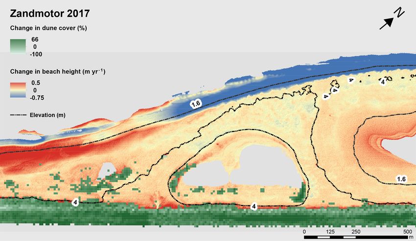
132 C. Nolet and M. J. P. M. Riksen: Accommodation space indicates dune potential
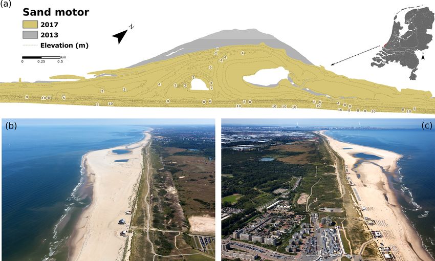
Figure 1. The Zandmotor (“sand motor”), an experimental mega-scale beach nourishment located along the Delfland coast, the Netherlands.
(a) The design of the Zandmotor mirrors the onshore migration of an (intertidal) sandbar and aims to provide coastal safety by redistributing
its sand along the coastline, thereby broadening the beach and dunes. (b–c) Aerial photographs of the Zandmotor and Delfland coast taken
on 9 July 2017, facing north (b) towards The Hague and south (c) towards the harbor of Rotterdam. The Delfland coast maintains relatively
wide and natural dune areas, but in some places the dunes are no more than a narrow foredune ridge directly bordered by urbanized areas.
Table 1. Sentinel-2A bands in VIS and NIR used for linear spectral number of endmembers, fk is the proportion of endmember
unmixing procedure. k within each pixel, Rik the spectral reflectance of endmem-
ber k within each pixel on band i, and ei is the residual error
Central Bandwidth Pixel term (Lu et al., 2003). Here, two endmembers were specified
Band wavelength (nm) (nm) size (m) (see Fig. 2). The first endmember was made up by a group of
2 – Blue 496.6 98 10 pixels (∼ eight) containing only beach sand, the second end-
3 – Green 560.0 45 10 member by a similarly sized group of pixels fully covered
4 – Red 664.5 38 10 by marram grass. The spectra of the two endmembers were
8 – NIR 835.1 145 10 obtained for each Sentinel-2 image separately, and maps con-
taining subpixel proportions of beach sand and marram grass
were derived using ENVI version 4.8 (Exelis Visual Infor-
acteristics (e.g., Smith et al., 1985; Settle and Drake, 1993; mation Solutions, Boulder, Colorado). The subpixel propor-
Theseira et al., 2003). It has successfully been applied before tions of marram grass were subsequently interpreted as a per-
by Lucas et al. (2002) and Zhang and Baas (2012) in map- centage dune cover within each 10 m pixel. Older established
ping the abundance of vegetation, including marram grass, dunes (with NDVI > 0.6 in Fig. 2) were excluded from the
in coastal dune environments. The reflectance at each pixel analysis as they are minimally exposed to marine forces and
of the image is assumed to be a linear combination of the mostly covered with vegetation species other than marram
reflectance of the endmembers present within the pixel: grass. Further, all artificial structures on the beach related to
n
X coastal safety (e.g., groynes) and leisure and recreation were
Ri = (fk Rik ) + ei , (1) masked from the imagery before the linear spectral unmixing
k=1 procedure was executed.
where i = 1, . . ., m are the number of spectral bands, Ri is Changes in dune cover by marram grass along the Delfland
the reflectance of band i of each pixel, k = 1, . . ., n are the coast were obtained by subtracting the percentages of dune
Earth Surf. Dynam., 7, 129–145, 2019 www.earth-surf-dynam.net/7/129/2019/
C. Nolet and M. J. P. M. Riksen: Accommodation space indicates dune potential 133
Figure 2. Map of the Zandmotor indicating Normalized Difference Vegetation Index (NDVI), and to illustrate the Sentinel-2 imagery and
selection of endmembers (user-specified ground cover components) for the linear spectral unmixing procedure. Subpixel proportions of
beach sand and marram grass (for every 10 m pixel) were derived using endmember reflectance spectra for four bands in the visible and
near-infrared spectral ranges.
cover calculated for the 2016 Sentinel-2 image from the and have been made public under a Creative Commons Zero
snapshot of 2017. Changes in dune cover between 2016 and (CC0) statement. The contractor responsible for the lidar
2017 were expressed for every 10 m pixel but also as an flights guaranteed a minimum density resolution of 1 laser
alongshore change in cover area (m2 m−1 yr−1 ). This was point per square meter, with a systemic vertical error equal
done for better interpretation of dune dynamics along the to or less than 2.6 cm and standard deviation equal to or less
Delfland coast and was calculated by multiplying the surface than ±2.0 cm. Five yearly DTMs of the Delfland coast were
area of each pixel (100 m2 ) by its fractional cover change. used for analysis, acquired in spring 2013 until spring 2017.
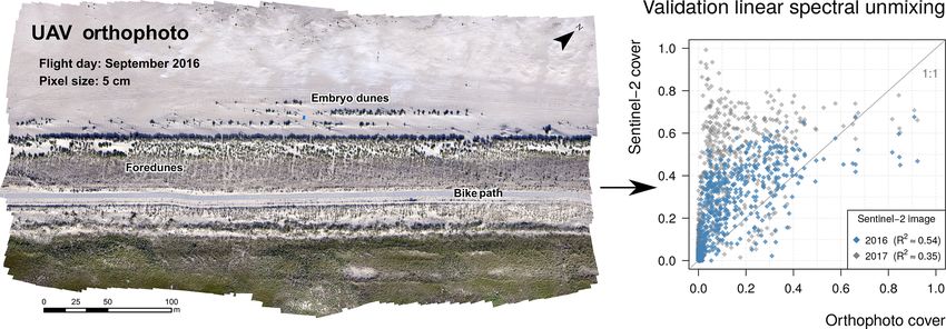
The linear spectral unmixing procedure was validated against Changes in coastal morphology were first expressed by av-
a high-resolution orthomosaic of a stretch of foredune di- erage change in height per year (m yr−1 ), which was calcu-
rectly adjacent to the Zandmotor (see also Fig. 3). The geo- lated per consecutive time step: t5−1 = (t2−1 + t3−2 + t4−3 +
referenced orthomosaic (5 cm pixel size) was obtained by an t5−4 )/4. This was done to better consider temporal varia-
unmanned aerial vehicle (UAV) during a flight on 1 Septem- tions within each year and to account for yearly changes of
ber 2016, so 10 days before the acquisition date of the the shoreline. Coastal morphological changes were also ex-
2016 Sentinel-2 image. Using a k-means clustering algorithm pressed as an average (alongshore) change in sand volume
(Hartigan and Wong, 1979), the individual 5 cm pixels of the per year (m3 yr−1 or m3 m−1 yr−1 ). Sand volume changes
orthomosaic were classified either as beach sand or marram were likewise calculated per consecutive time step and ob-
grass. The accuracy of the algorithm was confirmed by visual tained by multiplying the surface area of each pixel (4 m2 )
inspection; for more details about acquisition and process- by its yearly change in height. The quality of the DTMs
ing of the UAV-derived data the reader is referred to Nolet were verified by comparing the height of features along the
et al. (2017). The orthomosaic was subsequently resampled coastline that remained unchanged between 2013 and 2017
to match the 10 m pixel size resolution of the Sentinel-2 im- (e.g., parking lots, paved roads, building rooftops). The av-
agery and dune cover depicted in the orthomosaic was cal- erage standard deviation of the vertical component of the
culated as the proportion of the (former) 5 cm pixels classi- five DTMs (using ≈ 100 samples) was determined to be
fied as marram grass contained within each newly aggregated ±2.4 cm. Data are available at https://rijkswaterstaat.nl/apps/
10 m pixel. geoservices/geodata/dmc (last access: 16 January 2018). The
Delfland coast considered in the analysis covers a subaerial
area of about 500 ha and extends in the landward direction
2.3 Coastal morphology until the older established dunes. This approximately coin-
cides with the paved bike-path (gray line in Fig. 1) running
Data on the morphology and morphological changes in the along the crest of the newly created foredune ridge. In order
Delfland coast were obtained from digital terrain models to compare the morphology and morphological changes in
(DTMs) provided by Rijkswaterstaat, the executive agency the Delfland coast against the presence of dunes and changes
of the Ministry of Infrastructure and Water Management. in dune cover by marram grass, the 2 m resolution DTMs
The 2 m pixel size DTMs are produced every year (since
1996) for coastline monitoring purposes by airborne lidar
www.earth-surf-dynam.net/7/129/2019/ Earth Surf. Dynam., 7, 129–145, 2019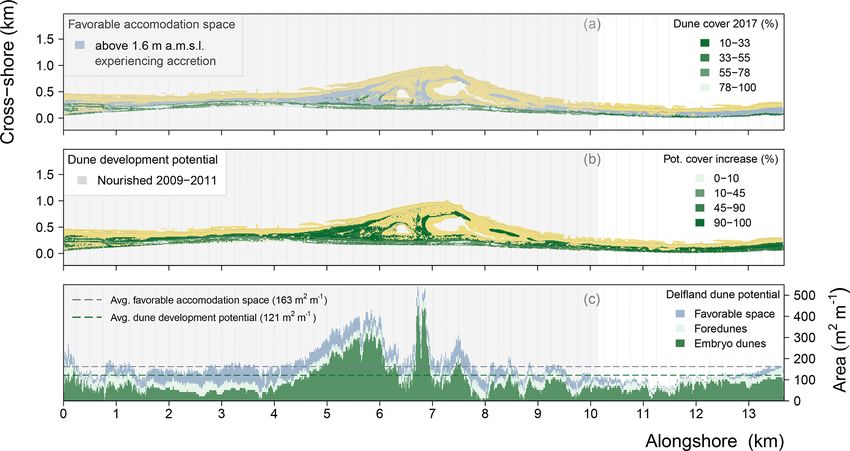
134                                           C. Nolet and M. J. P. M. Riksen: Accommodation space indicates dune potential

Figure 3. Validating the linear spectral unmixing procedure on the Sentinel-2 images using an orthophoto (5 cm pixel size) derived in
September 2016 by an unmanned aerial vehicle (UAV). Linear spectral unmixing produces a systematic overestimation of subpixel propor-
tions of marram grass cover compared to the cover values calculated from the orthophoto. A positive linear regression model explains 54 %
of the variance for the 2016 Sentinel-2 image and 35 % of the variance for the 2017 image.

were resampled using bilinear interpolation to match the               that the toe of the foredunes, compared to their construction
10 m pixel size of the Sentinel-2 imagery.                             height in 2011, have been raised by about 2 m due to aeolian
                                                                       deposition. The second map (Fig. 4b) shows how the sub-
                                                                       aerial coastal morphology changed between 2013 and 2017,
3   Results                                                            expressed by the average yearly change in height (m yr−1 ). It
                                                                       is clear that the most seaward part of the Zandmotor experi-
Figure 3 shows the results of validating the linear spectral un-       enced strong erosion due to marine forcing, while most of the
mixing procedure on the Sentinel-2 images. The dune cover              foredunes and particularly the beach just south and north of
calculated from the orthophoto and the two Sentinel-2 im-              the Zandmotor experienced accretion due to sand-spreading
ages are plotted against each other in Fig. 3b. It is clear            effects. The base of the Zandmotor with its high construction
that deriving subpixel proportions of dune cover using lin-            height either remained relatively stable or experienced mod-
ear spectral unmixing results in an overestimation of dune             erate erosion. These morphological dynamics are more dis-
cover by marram grass. Even though 54 % of the variance                tinctly reflected in Fig. 4c, which shows the average along-
for the 2016 Sentinel-2 image can be explained by a posi-              shore change in coastal sand volumes (m3 m−1 yr−1 ) be-
tive linear regression model, most of the data points deviate          tween 2013 and 2017. On average, the Delfland coastline has
from the 1 : 1 identity line because of higher dune cover val-         been accretive, at a rate of 19.3 m3 m−1 yr−1 , but it is clear
ues calculated by the Sentinel-2 image. This trend, however,           that there has been a high alongshore variability in sand ac-
appears to be systematic to the linear spectral unmixing pro-          cretion and erosion rates. This can be attributed to the antic-
cedure since the data points from the 2017 Sentinel-2 image            ipated behavior of the Zandmotor: the accretive areas on its
deviate even further from the identity line. This lower corre-         flanks gained approximately 2.8×10⁵ m3 yr−1 of sand, while
lation (R 2 ≈ 0.35) is in line with expectation as dune cover          the erosive areas on its base lost about 1.7 × 10⁵ m3 yr−1 of
by marram grass was observed to have increased at this loca-           sand. Further, the foredunes experienced accretion of sand
tion between 2016 and 2017. So even though the linear spec-            at relatively stable alongshore rates. In total, at an average
tral unmixing procedure overestimates the subpixel propor-             rate of 11 m3 m−1 yr−1 , the foredunes along the Delfland
tions of dune cover, the derived marram grass cover values             coast gained approximately 1.6 × 10⁵ m3 yr−1 of sand be-
for each Sentinel-2 image appear to be comparable relative             tween 2013 and 2017.
to each other.                                                            The third map (Fig. 4d) shows how the dune cover by Mar-
   Figure 4 shows the derived maps used to identify favorable          ram grass (expressed as percentage per 10 m pixel) changed
accommodation space for dune development. The first map                along the Delfland coast between the acquisition dates of the
(Fig. 4a) gives an overview of the morphological features, in-         two Sentinel-2 images. Using changes in marram grass cover
cluding the Zandmotor, during early spring 2017. The beach             as a proxy for dune development potential, it appears that
ranges between 0 and 6 m a.m.s.l. in height and this is where          in most places the dunes along the coastline have been ex-
new embryo dunes have either formed or expanded since                  panding over the course of a year. This observation, how-
2011. The foredunes are exclusively covered by marram                  ever, must be considered with some reservation, as observed
grass and stretch fully along the coastline, albeit at variable        changes in marram grass cover may also have been due to
widths, at heights between 6–14 m a.m.s.l. This indicates

Earth Surf. Dynam., 7, 129–145, 2019                                                        www.earth-surf-dynam.net/7/129/2019/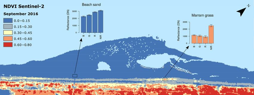
C. Nolet and M. J. P. M. Riksen: Accommodation space indicates dune potential                                                       135

Figure 4. Morphological changes and dune vegetation-cover dynamics of the Delfland coast. (a) Map of the considered domain including the
relevant morphological features (beach, foredunes, embryo dunes) in 2017. (b) Map of subaerial coastal morphological changes between 2013
and 2017, expressed average change in height per year (m yr−1 ). (c) Average alongshore changes in coastal sand volumes (m3 m−1 yr−1 )
between 2013 and 2017 for the Delfland coast and differentiated by the beach (embryo dunes included) and foredunes. (d) Map of changes
in dune cover by marram grass between 2016 and 2017, expressed as percentage per 10 m pixel. (e) Alongshore changes in marram grass
dune cover (m2 m−1 yr−1 ) between 2016 and 2017, with differentiation between the foredunes and embryo dunes.

denser or taller growth of marram grass and not because                have declined somewhat in cover. This decline is most ap-
of actual lateral expansion. Having said that, Fig. 4d sug-            parent north of the Zandmotor, which is clearly reflected in
gests that particularly the embryo dunes have been expand-             the second graph (Fig. 4e) that shows the alongshore yearly
ing, from 3 to 5 ha between 2016 and 2017. As a result, in             change in dune cover (m2 m−1 yr−1 ) between 2016 and 2017.
2017 about 17 % of the dunes along the Delfland coast could            This northerly foredune decline will be examined in more de-
be considered embryo dunes, of which most developed nat-               tail in the discussion, but it can likely be attributed to anthro-
urally along the coastline. The foredunes, in contrast, ap-            pogenic disturbances (due to recreational activities as well
pear to have experienced more spatial variation in marram              as nature management practices) and to the fact that this
grass cover changes. Figure 4d suggests that, along most of            stretch of coastline has not been nourished with sand when
the Delfland coast, the foredunes have been expanding be-              the Delfland coast was reinforced between 2009 and 2011.
tween 2016 and 2017. However, especially at the dune toe               All in all, data from Sentinel-2 imagery suggests that the
and just leeward of the dune crest, the foredunes appear to            dunes along the Delfland coast have been expanding between

www.earth-surf-dynam.net/7/129/2019/                                                         Earth Surf. Dynam., 7, 129–145, 2019
136 C. Nolet and M. J. P. M. Riksen: Accommodation space indicates dune potential
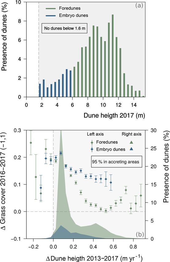
beach between 1.6 and 6 m a.m.s.l., while the foredunes were
located at heights between 6 and 14 m a.m.s.l. This suggests,
at least for 2017, that dunes along the Delfland coast were
sheltered from storm impacts above a height of 1.6 m a.m.s.l.
Accommodation space, as a result, is considered favorable
for dune development above this boundary height. The sec-
ond condition is identified (or verified as the positive effect
of sand burial on marram grass vigor, which is well docu-
mented) by comparing the changes in dune cover by marram
grass between 2016 and 2017 to the average yearly change
in dune height between 2013 and 2017 (see Fig. 5b). Several
observations can be drawn from that comparison but, most
importantly, it demonstrates that 95 % of all dunes along the
Delfland coast in 2017 (both embryo dunes and foredunes)
were present in areas that experienced on average a continu-
ous accretion of sand from 2013 to 2017. This indicates that
favorable accommodation space for dune development can
indeed be characterized by a steady accumulation of sand.
And since all dunes in 2017 were located above a height of
1.6 m a.m.s.l., it is reasonable to assume that this accumu-
lation of sand occurred predominantly by aeolian forcing.
In addition, Fig. 5b shows that almost all dunes increased
in cover by marram grass between 2016 and 2017. Over-
all this increase in cover was most pronounced for the em-
bryo dunes, as the foredunes showed limited increase and
even some decrease in dune cover towards higher changes
in dune height. The largest increase in dune cover between
2016 and 2017, however, coincided with the same change in
dune height (∼ 0.1 m yr−1 ) for both the embryo dunes and
the foredunes.
The identified accommodation space favorable for dune
Figure 5. Identifying favorable accommodation space for dune de- development (i.e., located above 1.6 m a.m.s.l. in height and
velopment (both foredunes and embryo dunes) along the Delfland experiencing a steady accumulation of wind-blown sand) is
coast. (a) Comparing the presence of dunes in 2017 to its eleva- shown in Fig. 6a. Including the parts that were already cov-
tion: no dunes present below 1.6 m a.m.s.l. Comparing the changes ered by marram grass, it is clear that large areas along the
in dune cover by marram grass from 2016 to 2017 to the average Delfland coast were favorable for dune development in 2017.
yearly change in dune height between 2013 and 2017: most dunes Especially the sheltered and accreting southern and middle
were present in accreting areas (right axis) and almost all dunes part of the Zandmotor stood out for its large favorable ac-
increased in cover by marram grass between 2016 and 2017 (left
commodation space for dunes to develop. This is reflected
axis).
more clearly by Fig. 6c, which shows the favorable accom-
modation space along the Delfland coast (in m2 m−1 ) as well
as the potential for new dune development. As Fig. 6b shows,
2016 and 2017 at an average rate of about 11.2 m2 m−1 yr−1 . this potential is calculated by subtracting the dune cover al-
For the foredunes, this amounted to an increase in dune cover ready present in 2017 from the total favorable accommoda-
of 42 to 54 ha. Although, as stated before, this may be an ex- tion space. Fig. 6c makes it clear that dune development po-
aggerated number as increase in dune cover by marram grass tential along the Delfland coast is mainly reserved for em-
has likely not been due to lateral growth alone. bryo dune development, as most of the favorable accommo-
Accommodation space is considered favorable for dune dation space is located on the beach. Further, Fig. 6c high-
development when it is (1) sheltered from frequent storm lights the overall importance of the Zandmotor for dune de-
impacts and (2) experiencing a steady accumulation of wind- velopment along the Delfland coast; by providing the largest
blown sand. The first (boundary) condition is identified by favorable accommodation space, the Zandmotor supports the
comparing the presence of dunes along the Delfland coast in highest potential for new dunes to develop. The existing fore-
2017 to the height at which they were located. As Fig. 5a dunes show a limited development potential as they are al-
demonstrates, in 2017 there were no dunes present below a ready quite densely covered by marram grass. Still, of the
height of 1.6 m a.m.s.l. All embryo dunes were located on the considered 500 ha domain of the Delfland coast, in 2017 an
Earth Surf. Dynam., 7, 129–145, 2019 www.earth-surf-dynam.net/7/129/2019/C. Nolet and M. J. P. M. Riksen: Accommodation space indicates dune potential 137
estimated two-thirds (∼ 165 ha) appears to have provided fa- tinue to grow until the surface is reached. Adventitious roots
vorable accommodation space for dunes to develop. are produced from the nodes of the vertical rhizome and
the horizontal rhizomes gradually die, so that the vertical
4 Discussion rhizomes become independent of one another. This process
may be repeated as long as aeolian supply is abundant and
This paper examined to what extent the Zandmotor has con- marram grass continues to trap sand. The capacity to trap
tributed to creating accommodation space favorable for dune sand, as noted before, is enhanced by the growth response
development along the Delfland coast. The results indicate of marram grass to sand trapping, which introduces the pos-
that the Zandmotor itself provides the most favorable ac- itive feedback mechanism driving coastal dune development
commodation space, for it has large areas located above (Gemmell et al., 1953; Ranwell, 1972). Using very high-
1.6 m a.m.s.l. that on average experience a continuous ac- resolution data, Nolet et al. (2017) showed that marram grass
cretion by wind-blown sand. As such, the results highlight on foredunes along the Zandmotor appears to thrive best un-
that the Zandmotor supports an especially high potential for der a sand trapping rate of approximately 0.3 m of sand per
new embryo dunes to develop as most of its accommoda- growing season and that marram grass can withstand sand
tion space is located on the beach. This section examines the burial of up to 1 m of sand. However, while this demon-
merit of the identified conditions for when accommodation strates how positive plant–sand feedback steers dune devel-
space is considered favorable for dune development, as well opment, it must be noted that the physical size of a develop-
as the merit of using favorable accommodation space to in- ing dune and predominant wind regime also controls its mor-
dicate dune development potential. The latter is examined in phology (Davidson-Arnott et al., 2018). As dunes grow, for
relation to the design and intended dynamical nature of the example, a limit is imposed on its height because the wind
Zandmotor, the conditions required for successful establish- force required to transport sand upslope increases signifi-
ment of marram grass and the persistent anthropogenic dis- cantly (e.g., Arens et al., 1995; Arens, 1996; Keijsers et al.,
turbances along the Delfland coast arising from recreation 2015a). Coastal foredunes therefore tend to expand in width
and nature management practices. rather than height, which emphasizes the importance of the
wide favorable accommodation space the Zandmotor pro-
vides for foredune development.
4.1 Conditions indicating favorable accommodation
The condition that accommodation space is considered fa-
space for dune development
vorable when it is sheltered from storm impacts warrants
Accommodation space is considered favorable for dune de- closer inspection, because the impacts of a storm surge de-
velopment when it is sheltered from storm impacts and ex- pend both on the magnitude of the storm as well as the ge-
periences a steady accumulation of wind-blown sand. The ometry of the beach (Houser et al., 2008). Wind stress due
latter condition is not disputed, as the reinforcing feedback to atmospheric pressure differences drive storm surge levels
between the growth response of marram grass and burial by and offshore wave conditions, but the vertical dimension of
wind-blown sand is well documented (Huiskes, 1979; Dis- the beach profile, in particular, exerts great control on shore-
raeli, 1984; Maun and Lapierre, 1984; Van der Putten et al., line parameters such as wave setup, swash and run-up (e.g.,
1988; Hesp, 1991; Maun, 1998) and recognized to be fun- Stockdon et al., 2006; Sallenger Jr., 2000; Ruggiero et al.,
damental to coastal dune development in temperate regions 2001). This is significant because the dissipation of kinetic
around the world (e.g., Baas and Nield, 2010; Durán and energy of breaking waves is responsible for the highest rates
Moore, 2013; Keijsers et al., 2016; Nolet et al., 2017). The of coastal erosion and dune decline (e.g., Vellinga, 1982;
positive feedback mechanism originates from a trait that all Short and Hesp, 1982). However, while empirical models can
beach grasses of the genus Ammophila possess, namely po- calculate wave run-up levels and wave breaking energy from
tentially unlimited horizontal and vertical growth through its parameters such as offshore wave conditions and beach pro-
rhizomes (Gemmell et al., 1953; Ranwell, 1972). Whether file (see Stockdon et al., 2006, and Sallenger Jr., 2000, for
marram grass grows horizontally or vertically subsequently details), those relations only return approximations as often
depends on the amount of wind-blown sand, which makes not all required model input is available or because of inher-
it so particularly advantageous to dune building. After es- ent model uncertainties. Having said that, the results suggest
tablishment, by seed or rhizome dispersal, marram grass that dunes along the Delfland coast are sheltered from storm
first produces leafy shoots along newly developing horizon- impacts above a beach height of 1.6 m a.m.s.l. This finding
tal rhizomes. When wind-blown sand is trapped by the leafy is examined in relation to offshore sea water levels measured
shoots, the immediate sand surface is raised and a small em- by a buoy in close proximity to the Zandmotor mega-scale
bryo dune is formed (Hesp, 1989). The leafy shoots are ca- beach nourishment. Figure 7 shows the probability density
pable of growing up through a moderate thickness of sand curve (which is bimodal because of tidal dynamics) of those
by elongation of individual leaves. If, however, a leafy shoot sea water levels (in m ± m.s.l.), measured every 10 min from
is overwhelmed by sand deposition, one or more of its ax- 2011 until 2017. Included are the instances when sea water
illary buds develop into a vertical rhizome that will con- levels exceeded the apparent 1.6 m a.m.s.l. boundary height
www.earth-surf-dynam.net/7/129/2019/ Earth Surf. Dynam., 7, 129–145, 2019138 C. Nolet and M. J. P. M. Riksen: Accommodation space indicates dune potential
Figure 6. Favorable accommodation space to indicate dune development potential along the Delfland coast. (a) Map of dune cover (%)
by marram grass in 2017 and accommodation space favorable for dune development: located above 1.6 m a.m.s.l. and experiencing an
accretion of sand. (b) Map indicating Delfland coast dune development potential, calculated as the potential of marram grass to increase in
cover (%) based on the accommodation space favorable for dune development and taking into account the dune cover already present in
2017. (c) Alongshore variation of favorable accommodation space and potential for dune development along the Delfland coast (m2 m−1 ),
differentiated for foredunes and embryo dunes.
was about 20 cm up to a sea water level of 1.8 m a.m.s.l., but
on a few occasions sea water levels almost doubled com-
pared to the boundary height to 3.10 m a.m.s.l. This is ex-
cluding the wave run-up onto the beach, which can be sig-
nificant for natural beaches in the Netherlands. Dependent
on whether the beach profile is dissipative or reflective, both
Stockdon et al. (2006) and Poortinga et al. (2015) show that
wave run-up may reach to heights from 0.85 to 1.45 m above
still water level, which is the level that would occur in the ab-
sence of waves. This implies that, since the construction of
the Zandmotor in 2011, the Delfland coast may have experi-
Figure 7. Bimodal probability density curve of sea water levels (in
enced coastal erosion by storm surge levels reaching heights
m ± m.s.l.) measured by a buoy near Scheveningen since the con- up to at least 4 m a.m.s.l.
struction of the Zandmotor in 2011 until 2017. Included are the in- The observation that in 2017 quite a large number of em-
stances when sea water level exceeded the 1.6 m a.m.s.l. boundary bryo dunes were present on the beach at heights well below
height for dune development along the Delfland coast. the maximum experienced storm surge levels points to the
capacity of established dunes to withstand and recover from
hydrodynamic storm impacts as well as to the pivotal role
marine dispersal of rhizome fragments likely plays to dune
for dunes to be sheltered from storm impacts. It is clear from establishment processes. As remarked by various researchers
Fig. 7 that this did not occur frequently, only during about (e.g., Suanez et al., 2012; Feagin et al., 2015; Houser et al.,
0.4 % of the measurements. Those measurements, however, 2015; Van Puijenbroek et al., 2017a, b), the ability of em-
were relatively clustered together, meaning that the bound- bryo dunes to recover from storm impacts largely depends
ary height was exceeded over (relatively) prolonged periods on the extent to which the above- and belowground struc-
of time. Although, over the course of 6 years this happened tural integrity of marram grass remains intact after a storm
for no more than 10 full days. On average the exceedance
Earth Surf. Dynam., 7, 129–145, 2019 www.earth-surf-dynam.net/7/129/2019/C. Nolet and M. J. P. M. Riksen: Accommodation space indicates dune potential 139 Figure 8. The distribution of (embryo) dunes on the Zandmotor, suggesting a correlation to marine dispersal of rhizome fragments as a large number of embryo dunes are present between the identified boundary height of 1.6 m a.m.s.l. and the (current) maximum expected storm surge height of 4 m a.m.s.l. event. This depends, in turn, on the severity of the storm the dispersal of marram grass rhizome fragments and sub- impacts on the dune, which can be caused by wave erosion sequent dune establishment via clonal growth (Konlechner (scarping and overwash) and swash inundation (Sallenger Jr., and Hilton, 2009; Hilton and Konlechner, 2011). The distri- 2000; Hesp and Martínez, 2007). Wave erosion may com- bution of (embryo) dunes on the southern part of the Zand- pletely remove all sand from an embryo dune (so it is no motor, as shown in close-up in Fig. 8, suggests a correlation longer raised from the beach surface) and have an abrasive to marine dispersal of rhizome fragments as a large number effect on the leaves of marram grass, causing either minor of embryo dunes are present between the identified boundary damage or complete removal of all aboveground biomass. height of 1.6 m a.m.s.l. and the (current) maximum expected Most of the belowground root system of marram grass, how- storm surge height of 4 m a.m.s.l. The embryo dunes around ever, has been observed to largely remain intact after wave the small dune lake, while technically located in the same scarping or overwash (Feagin et al., 2015). Potential damage elevation zone, have likely mostly established by seed ger- of swash inundation to marram grass depends on the dura- mination as the high constructed base of the Zandmotor has tion of the inundation period, but as Vergiev et al. (2013) completely blocked all storm surge impacts until now. Over demonstrate, marram grass displays no visible decomposi- the years there has been a steady build-up of a freshwater lens tion of stems, roots or rhizomes after being immersed with under the Zandmotor and the salinity of the dune lake has sea water for 20 days. This is well beyond the period a significantly decreased as a result (Huizer et al., 2016). This beach will be inundated after a storm event, which implies fresh water availability, in combination with moderate burial that inundation has a limited, if any, negative effect on the dynamics, have been shown by Konlechner et al. (2013) to structural integrity of marram grass. Given that storm events be beneficial to marram grass seed germination and subse- occur more frequently in winter, it has been observed that quent dune establishment. The specific distribution of em- embryo dunes on dissipative beaches undergo a classic sea- bryo dunes around the dune lake may therefore correlate best sonal cycle of erosion during the winter and accretion during to seed dispersal by wind coming from the dominant south- the summer (Montreuil et al., 2013; Van Puijenbroek et al., western wind direction, either pushing the seeds over the lake 2017b). Their presence on the beach, however, would remain towards the north-east corner of the lake or depositing it on persistent throughout the year and often show a yearly net the south-west lee side where the beach slopes downwards growth when aeolian supply was sufficient (Anthony et al., towards the lake. In effect, Fig. 8 illustrates that, even though 2007; Suanez et al., 2012). This not only indicates that em- the Zandmotor may provide wide favorable accommodation bryo dunes have the capacity to withstand storm impacts space and thus a high potential for dune development, the and quickly recover to prestorm conditions, but also that the conditions required for successful (natural) dune establish- above- and belowground structure of marram grass often re- ment must also be considered. Having said that, Puijenbroek mains largely intact after a storm event. Marine forcing, at (2017) showed in a field transplant experiment that planted the same time, has been shown to be an important agent in marram grass (consisting of a rhizome fragment with one www.earth-surf-dynam.net/7/129/2019/ Earth Surf. Dynam., 7, 129–145, 2019
140                                          C. Nolet and M. J. P. M. Riksen: Accommodation space indicates dune potential

shoot) thrived on most parts of the Zandmotor except when           disturbances arising from recreation and leisure as well as
exposed to direct wave action. This suggests that conditions        a (increasingly prevalent) nature management practice that
that limit marram grass growth and subsequent dune devel-           is aimed at remobilizing the dune landscape. Figure 9 gives
opment (e.g., high salinity, drought, low nutrient status) are      an overview of total alongshore changes in dune cover by
mostly absent on the Zandmotor and likely along the entire          marram grass between 2016 and 2017 (in m2 m−1 yr−1 ) and
Delfland coast.                                                     aims to relate it to anthropogenic activities that may impact
                                                                    (both positively and negatively) dune development along the
4.2   Dune development potential in relation to
                                                                    Delfland coast. In the broadest sense, the coastline can be di-
      anthropogenic impacts
                                                                    vided first according to whether or not it has recently been
                                                                    nourished with sand and what type of sand nourishment has
The results highlight the overall importance of the Zandmo-         been implemented. A distinction can be made between the
tor for dune development along the Delfland coast. First, this      sand nourishment that was carried out between 2009 and
is because its beach provides very wide favorable accom-            2011 to reinforce most of the Delfland coastline, the na-
modation space that therefore supports a high potential for         ture compensation project Spanjaardsduin implemented at
new embryo dune development. And second, because of its             the same time and, finally, the Zandmotor mega-scale beach
sand-feeding effects, the Zandmotor has likely contributed          nourishment that was completed at the end of 2011. Further,
to creating more favorable accommodation space for dune             within the nourished coastline there is a zone where the dune
development along the entire Delfland coast. The coastline          development appears to lag behind compared to the rest of
directly north of the Zandmotor, for example, experienced           the nourished coastline. This zone, as Fig. 9b illustrates, can
a significant accumulation of sand between 2013 and 2017            be characterized by a higher concentration of disturbances
even though it has not been nourished with sand in the years        arising from recreation and leisure. Then, finally, there is the
before. Although the amount of sand accumulation was less           northern part of the Delfland coastline that has not been nour-
compared to the coastline that has been nourished between           ished with sand in recent years. Within this zone, as Fig. 9c
2009 and 2011, the overall positive sand budget illustrates         shows, relatively large dune areas have been excavated be-
the intended dynamical nature of the Zandmotor, where its           tween 2011 and 2013 aimed at rejuvenating the dune land-
sand is redistributed along the coastline causing a seaward         scape by reinitiating aeolian dynamics. In the following para-
broadening of the beach and dunes. In fact, Fig. 6c suggests        graphs, each identified zone of the Delfland coast and how
that the unnourished northern part of the Delfland coastline        dune development potential may be impacted by the various
supports a higher potential for dune development compared           anthropogenic activities are discussed.
to the nourished southern coastline. In part this may be due to        As Fig. 9c shows, the overall positive effect of the three
the fact that the Delfland coast is characterized by a net north-   sand nourishment schemes on dune development is clearly
ward sediment transport regime (Van Rijn, 1997), which is           reflected in the changes in marram grass cover between 2016
reflected in the sand-feeding budget of the Zandmotor. In the       and 2017. Within the nourished zone, however, there are
first 18 months after its completion, De Schipper et al. (2016)     three clear dips where the dune cover appears to have de-
for example show that up to 40 % more sand of Zandmotor             creased over the course of a year. Upon closer inspection it
was transported in a northward direction rather than south-         seems that each dip coincides with a beach entrance where
ward towards Rotterdam harbor. At the same time, because            the public can enter the beach. A number of natural processes
the 2009–2011 nourishment strategy consisted (for a large           and human activities may be involved here in the observed
part) of foredune reconstruction that included plantings of         decline in marram grass cover. First of all, as Fig. 9b shows,
marram grass, the created favorable accommodation space             the seaward side of a beach entrance is commonly paved with
along the nourished coastline may not accommodate much              concrete slabs and cuts relatively deep into the stoss slope
new dune development. As such, even though the coastline            of the foredune. This, effectively, mimics a through fore-
south of the Zandmotor has been reinforced with sand nour-          dune blowout (e.g., Hesp, 2002), in which wind erosion is
ishment, it is quite possible for the unnourished northern          enhanced because of local wind speed acceleration and pro-
Delfland coastline to experience more pronounced dune de-           nounced turbulent flow structures such as corkscrew vortices
velopment in the years to come.                                     (Hesp and Martínez, 2007). Because the floor is paved, these
   Interestingly, however, the positive effect of the Zandmo-       wind-driven forces will in particular erode (i.e., widen) the
tor on the northern Delfland coastline, in terms of sand ac-        slopes of the beach entrance and this susceptibility to lat-
cretion, is not reflected in the changes in cover by marram         eral erosion may have lead to the observed decline in marram
grass between 2016 and 2017. Even though it is shown that           grass cover. Second, as can also be seen in Fig. 9b, there is
the coastline north of the Zandmotor provides ample favor-          often a hospitality establishment (e.g., a beach bar or restau-
able accommodation space, it appears that the potential for         rant) directly beside a beach entrance. And although their
dune development is currently not being realized. There are         placement on the beach is often seasonal, their presence is
two main anthropogenic impacts that may hamper dune de-             numerous. In the summer of 2017, for example, only 3 of the
velopment along this urbanized coastline, namely persistent         23 beach entrances along the Delfland coast did not have one

Earth Surf. Dynam., 7, 129–145, 2019                                                    www.earth-surf-dynam.net/7/129/2019/
C. Nolet and M. J. P. M. Riksen: Accommodation space indicates dune potential 141
Figure 9. Overview of total alongshore changes in dune cover by marram grass between 2016 and 2017 (in m2 m−1 yr−1 ) in relation to
anthropogenic activities that impact (positively and negatively) dune development along the Delfland coast. Aerial photographs courtesy of
René Oudshoorn (a) and Google Maps (b).
or more hospitality establishments directly placed besides minimize interference with the wind flow and resultant aeo-
it. Perhaps not coincidentally, two of those three entrances lian dynamics. Further, another important anthropogenic dis-
gave access to the more isolated parts of the Zandmotor. The turbance with a highly negative impact to dune development
presence of hospitality establishments puts additional pres- is that the beach directly north of the Zandmotor is mechan-
sure on the dunes as people may flock around the beach en- ically raked during the summer to remove wrack line mate-
trances and motorized vehicles are more common, e.g., to rial and human litter. Even though it is a common practice
resupply the establishment. Even though walking or driving to accommodate beach recreation (Jackson and Nordstrom,
in the foredunes is prohibited along the Delfland coast, sev- 2011), this severely hampers embryo dunes from establish-
eral studies (e.g., Andersen, 1995; Anders and Leatherman, ing themselves on the beach. Not only can the machinery de-
1987) show that vehicles and people on the beach may have stroy any sprouting seedlings or rhizomes of marram grass,
a significant negative effect on dune development. the removal of wrack deposits also deprives marram grass
At the same time, as laid out in more detail by Jackson from potential hospitable locations to establish itself on the
and Nordstrom (2011), the structure of the hospitality estab- beach (Kelly, 2014). As a result, these anthropogenic dis-
lishment itself may alter (i.e., block) aeolian transport from turbances combined have likely contributed to reduced dune
the beach and retard foredune development. This plays an development compared to the rest of the nourished Delfland
even larger role in the nourished zone north of the Zandmotor coastline.
where, besides a large number of hospitality establishments, Then, as Figs. 9c and 4e show, the decrease in mar-
a high amount of seasonal beach cabins are also placed along ram grass cover along the unnourished northern part of the
the toe of the foredunes from March until October (from Delfland coastline suggests that the foredunes have been in
2016 onward). Their placement close together, as Fig. 9a decline between 2016 and 2017. This is unexpected consider-
shows, has the additional effect that the airflow can constrict ing the positive sand-feeding effect of the Zandmotor on this
and accelerate between the beach cabins, which increases stretch of coastline. Upon closer inspection, the main can-
the likelihood of local scour resulting in aeolian deposition didates for the observed foredune decline are a number of
farther landward (Nordstrom, 2004). Although in some in- dune excavations aimed at rejuvenating the dune landscape.
stances this may actually be beneficial to the foredunes, the When the focus of Dutch coastal policy widened, to also in-
clear decline in cover by marram grass (see Fig. 9c) indicates clude preserving the spatial quality and natural values of the
that the placement of beach cabins had an overall negative coastal zone, it was recognized that traditional flood safety
impact on dune development between 2016 and 2017. And measures had led to over-stabilized dune systems that were
while the beach cabins were in fact raised slightly from the characterized by a markedly reduced biodiversity compared
surface (∼ 50 cm), Nordstrom and McCluskey (1984) show to younger and more dynamic dune systems (e.g., van Dorp
that such a modest height may not have been sufficient to et al., 1985; Provoost et al., 2011). For that reason, in places
www.earth-surf-dynam.net/7/129/2019/ Earth Surf. Dynam., 7, 129–145, 2019You can also read