Active Transportation Plan - City of Millbrae - Adopted by the City Council on October 12, 2021 (Resolution No. 21-69) Final Publication on ...
←
→
Page content transcription
If your browser does not render page correctly, please read the page content below
City of Millbrae
               Active
        Transportation
                  Plan
                                              FINAL

Adopted by the City Council on October 12, 2021
                           (Resolution No. 21-69)
           Final Publication on January 24, 2022

                      KITTELSON & ASSOCIATES, INC.
                      115 Grande Avenue, Suite 505
                      Oakland, CA 94612 | P 510.839.1742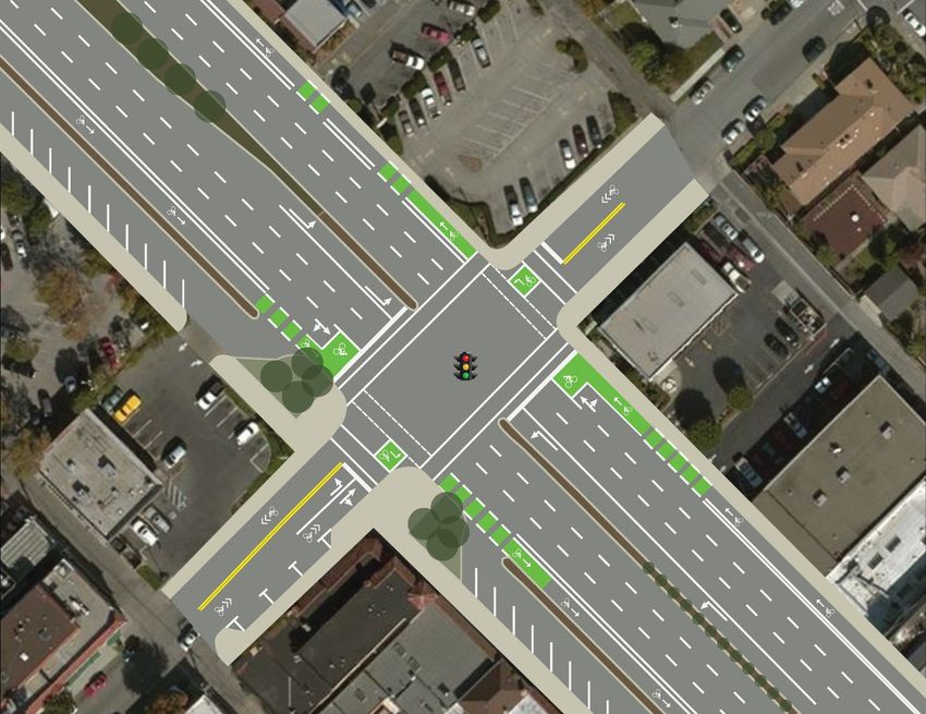
City of Millbrae                                                                                                                    Active Transportation Plan – Final

TABLE OF CONTENTS
LIST OF FIGURES.................................................................................................................................................................... 2
INTRODUCTION .................................................................................................................................................................... 3
   Vision................................................................................................................................................................................. 3
   Plan Purpose .................................................................................................................................................................... 3
CONTEXT AND REGULATORY FRAMEWORK ....................................................................................................................... 5
   Plan Context .................................................................................................................................................................... 5
   Regulatory Framework and Related Plans ................................................................................................................... 9
EXISTING CONDITIONS ...................................................................................................................................................... 13
   Existing Bikeway Network.............................................................................................................................................. 13
   Existing Pedestrian Network.......................................................................................................................................... 17
   Bicyclist and Pedestrian Counts................................................................................................................................... 18
   Commute Mode Share................................................................................................................................................. 21
   Bicycle and Pedestrian Crashes .................................................................................................................................. 22
NEEDS ................................................................................................................................................................................. 25
   Schools ........................................................................................................................................................................... 25
   Parks and Trails ............................................................................................................................................................... 27
   Destinations.................................................................................................................................................................... 28
   Transit .............................................................................................................................................................................. 29
   Barriers ............................................................................................................................................................................ 30
GOALS AND ACTIONS....................................................................................................................................................... 32
   Goals .............................................................................................................................................................................. 32
   Actions............................................................................................................................................................................ 32
RECOMMENDATIONS ........................................................................................................................................................ 34
   Walking Recommendations......................................................................................................................................... 34
   Biking Recommendations ............................................................................................................................................ 38
   Future Study Projects ..................................................................................................................................................... 42
   Supporting Recommendations.................................................................................................................................... 42
IMPLEMENTATION .............................................................................................................................................................. 44
   Cost Estimates................................................................................................................................................................ 44
   Conceptual designs...................................................................................................................................................... 47
   Potential Funding Sources ............................................................................................................................................ 53

January 23, 2022                                                                                                                                                                Page 1
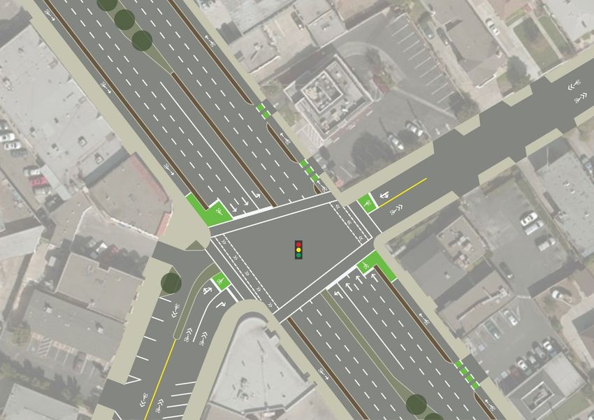
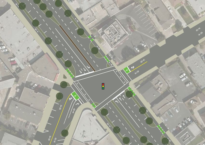
City of Millbrae                                                                                                           Active Transportation Plan – Final

LIST OF FIGURES
Figure 1: Regional Setting............................................................................................................................................ 7

Figure 2: Key Bicycle and Pedestrian Destinations ................................................................................................... 8

Figure 3: Existing Bikeway Facilities ........................................................................................................................... 16

Figure 4: Peak Period Bicycle Counts ...................................................................................................................... 19

Figure 5: Peak Period Pedestrian Counts................................................................................................................. 20

Figure 6: Bicyclist and Pedestrian Crashes (2014-2018) .......................................................................................... 23

Figure 7: Bicycle and Pedestrian Crashes by Severity, City of Millbrae, 2014-2018 ............................................. 24

Figure 8: Schools, Parks, and Trails ............................................................................................................................ 26

Figure 9: Proposed Pedestrian Improvements ........................................................................................................ 35

Figure 10: Proposed Bikeway Improvements .......................................................................................................... 39

Figure 11: US 101 Bicycle and Pedestrian Overcrossing Concept ........................................................................ 41

Figure 12. El Camino Real & Murchison Avenue Concept .................................................................................... 48

Figure 13. El Camino Real & Hillcrest Avenue Concept......................................................................................... 49

Figure 14. El Camino Real & Park Place/Santa Inez Avenue Concept – No Lane Reduction……. .................. 50

Figure 15: El Camino Real & Park Place/Santa Inez Avenue Concept – With Lane Reduction…… ................. 51

Figure 17. East Millbrae Avenue Concept ............................................................................................................... 52

January 23, 2022                                                                                                                                                   Page 2
City of Millbrae Active Transportation Plan – Final
INTRODUCTION
The City of Millbrae (City) and its consultant team have developed the City of Millbrae Active Transportation
Plan to improve the bicycling and walking environment in Millbrae and to achieve the benefits of an active
transportation network. This plan serves as a comprehensive action plan for the City to provide a safe and
comfortable bicycle and pedestrian network for its residents, employees, and visitors. This plan builds upon and
supersedes the City of Millbrae Bicycle and Pedestrian Transportation Plan that was adopted in August 2009.
Recognizing that bicycle and pedestrian facilities form an important component of the larger transportation
and recreation networks, this plan was developed in conjunction with the updates to the Millbrae General Plan
and Parks Master Plan.
The Active Transportation Plan is intended to achieve the mobility, environmental, and health benefits of
bicycling and walking, from both a recreation and transportation standpoint, that Millbrae and other cities
recognize are important to a thriving 21st century city. The development of this plan is a concerted effort to
improve the bicycle and pedestrian network in Millbrae to:
Provide more transportation choices;
Reduce vehicle traffic and its resultant noise, pollution, and greenhouse gas emissions; and
Promote physical activity and improve public health.
VISION
The City of Millbrae Active Transportation Plan is guided by the following vision:
The City of Millbrae Active Transportation plan envisions a safe, interconnected, and accessible
environment for bicyclists, pedestrians, and users of evolving modes of mobility of all ages and abilities. The
plan’s vision consists of a network that is complete and provides convenient walking and biking facilities to
local and regional destinations and amenities.
PLAN PURPOSE
This plan serves as a guiding document for the City to improve bicycling and walking conditions in Millbrae. It
also is a guide to create a local bicycle and pedestrian network that is integrated into the regional active
transportation network and transit systems. This plan sets a course of action for the City to create a safer and
more comfortable bicyclist and pedestrian environment for residents, employees, and visitors by:
Providing an understanding of the existing active transportation conditions. Understanding current
conditions in the city is essential to determine needs and areas for improvement. This plan describes existing
bicycle and pedestrian facilities, the current regulatory framework, commute patterns, and mode choice
trends that inform the City’s goals and actions.
Assessing bicyclist and pedestrian needs in the city. This plan examines the bicycle and pedestrian needs
across the city, including the needs of different user groups and for various destinations. These bicycling
and pedestrian needs are identified and then used to shape the City’s goals and actions.
Presenting a set of goals and actions to achieve the City’s vision. The goals and actions set forth in this plan
provide guidance for the City as it works to improve existing facilities and construct new facilities to provide
a safer and more comfortable active transportation system in Millbrae.
Identifying priority bicycle and pedestrian projects. This plan provides a list of priority bicycle and
pedestrian projects based on the needs identified through development of this plan. By implementing
projects from the list, the City can implement improvements with confidence that users’ needs will be met.
January 23, 2022 Page 3
City of Millbrae Active Transportation Plan – Final
Developing cost estimates for key priority projects. Accurately understanding the level of effort and
resources required to enhance the active transportation network is essential to implement the priority
projects. Therefore, this plan includes preliminary cost estimates for the priority bicycle and pedestrian
projects identified in the plan.
Identifying funding opportunities to augment local funds. Recognizing the realities of funding constraints,
this plan identifies other sources that the City can utilize to complement its funds (e.g., county, regional,
state, and/or federal funding sources). Securing additional resources will help the City implement the
improvements identified in this plan to address users’ needs.
January 23, 2022 Page 4
City of Millbrae                                                                      Active Transportation Plan – Final

CONTEXT AND REGULATORY FRAMEWORK
PLAN CONTEXT
The City of Millbrae developed this active transportation plan to identify bicyclist and pedestrian needs across
the city, develop a set of goals and actions to address those needs, and create an active transportation
network that provides safe and comfortable facilities to encourage biking and walking in the city. An
understanding of current conditions for bicyclists and pedestrians in Millbrae is essential to create a bicycle and
pedestrian network that addresses the City’s goals. Multimodal volumes and crash data were collected and
analyzed, and existing mode share and facilities were evaluated to identify the bicycling and pedestrian needs
in the city. Analysis of these data supports the development of planned bicycle and pedestrian improvements
for the City of Millbrae.

SETTING
Millbrae is in northern San Mateo County. It is bordered by (clockwise from the northeast) San Francisco
International Airport, San Francisco Bay, the City of Burlingame, unincorporated San Mateo County, and the
City of San Bruno. Millbrae and the surrounding regional setting are shown in Figure 1. This city has an area of
3.26 square miles and a population of 22,394 people, according to the 2019 U.S. Census estimates.
Approximately 4,300 residents (19 percent) are under the age of 18, and an additional approximately 4,300
residents (19 percent) are 65 years of age or older. These groups represent a substantial proportion of Millbrae’s
population that may have limited mobility or mobility choices and could benefit the most from safe and
comfortable active transportation facilities.

According to 2019 American Community Survey (ACS) Five-Year Estimates, approximately 5 percent of
households in Millbrae do not own a car and instead depend on other modes of transportation (such as
bicycling, walking, or taking transit) to reach their destinations.

Selected socioeconomic data for the city, county, state, and national level are presented in Table 1. As
presented in the table, the proportion of households without a vehicle is slightly lower in Millbrae when
compared to state and national data. While the proportion of the population under 18 years of age is lower in
Millbrae than across the county, state, and nation, the proportion of people 65 years of age or older is slightly
higher than the county, state, and nation.

Table 1: Select Socioeconomic Data

                                                            San Mateo
                                         Millbrae             County                 California       United States
 Under 18 years of age1                    19%                  20%                     23%                22%

 65 years of age or older1                 19%                  17%                     15%                17%

 Households without vehicles2               5%                   5%                     7%                  9%

Sources: 2010 U.S. Census; 2012-2016 American Community Survey Five-Year Estimates

Millbrae has a temperate climate. Its topography ranges from the relatively flat terrain of the San Francisco Bay
shoreline to the steep hills and ravines of the western neighborhoods, to the Sawyer Camp Trail and San
Andreas Trail in the San Andreas Reservoir area parallel to Interstate 280 (I-280). El Camino Real (State Route 82,
a State highway under Caltrans jurisdiction) runs north-south and bisects the city. A curvilinear street network
and low-density residential neighborhoods compose the area to the west of El Camino Real. The downtown
area along Broadway and El Camino Real forms the commercial core of the city. The surrounding areas are
primarily residential, except for the Millbrae Intermodal Terminal and commercial uses along Millbrae Avenue.

January 23, 2022                                                                                                 Page 5
City of Millbrae Active Transportation Plan – Final
Key bicycle and pedestrian destinations in the city are shown on Figure 2:, and include:
Downtown Core: Employment centers and businesses are concentrated in Millbrae’s downtown area,
primarily along Broadway. Millbrae City Hall, Millbrae Police Department, Central County Fire Station 37,
Millbrae Library, and the Millbrae History Museum to the west of Broadway are in downtown. A U.S. Postal
Service office is in downtown on Broadway at Taylor Boulevard.
El Camino Real Commercial Corridor: Businesses and other commercial facilities exist along El Camino Real
(State Route 82) to the east of downtown.
Schools: Schools in Millbrae consist of Millbrae Nursery School, Glen Oaks Montessori, Green Hills Elementary
School, Lomita Park Elementary School, Meadows Elementary School, Spring Valley Elementary School,
Taylor Middle School, St. Dunstan’s School, Mills High School, and Capuchino High School (located in the
City of San Bruno but surrounded by the City of Millbrae).
Parks and Recreational Areas: Parks and recreational facilities in Millbrae include Bayfront Park, Bayside
Park, Central Park, and Spur Trail Park. In addition, neighborhood parks are dispersed throughout the city.
Recreational Trails: Recreational trails consist of trails that are conducive to bicycling and walking and can
connect people to other recreational facilities in the region. Trails within and adjacent to Millbrae are the
Bay Trail, San Andreas Trail, Sawyer Camp Trail, and Spur Trail. These trails also provide broader regional
access to the broader trail system including the Fifield Cahill Ridge Trail to the west of Millbrae in the
unincorporated county..
Regional Transit: The Millbrae Intermodal Terminal is northeast of the intersection of El Camino Real and
Millbrae Avenue. The station provides access to BART and Caltrain and is a future stop on the California
High Speed Rail line. It is also a regional transit hub for SamTrans.
Local Transit: Millbrae residents, employees, and visitors can access the SamTrans Route ECR bus (providing
express service) from any of several bus stops along El Camino Real. Running north-south between Daly City
and Palo Alto, Route ECR serves destinations along El Camino Real, with stops within walking distance of
downtown Millbrae and the Millbrae Intermodal Terminal.
January 23, 2022 Page 6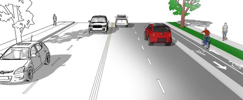
Figure 1: Regional Setting
                      _To
                        San Francisco
                                            82
                                            þ
                                            }
                                            |
                                            ·
                             §
                             ¦
                             ¨280
                                                                            C O L M A C REEK

                      35
                      þ
                      }
                      |
                      ·

                                                                City of
                                                              San Bruno                             SAN FRANCISCO
                                                                                                INTERNATIONAL AIRPORT

                                                                                         82
                                                                                         þ
                                                                                         }
                                                                                         |
                                                                                         ·
                                                                                City of
                                                                                                                  £101
                                                S A N A N D R E AS LAKE
                                                                                Millbrae                          ¤
                                                                      §
                                                                      ¦
                                                                      ¨   280
                                                                                                                                                 L A G OON

                                                                                                        City of
                                                                                                      Burlingame

                                                                                                                                                                 S A N M A T E O C R E E K CHANNEL

                                                                                                   S P E N C E R LAKE
                                                                                                                                                                                           S L O UGH

                                          P I L A R C I T O S RESERVOIR                                                                                                                             S L O UGH
                                                                                                                                                                                              S L O UGH

                                                                                  U P P E R C R Y S T A L S P R I NGS RESERVOIR

 Source: Milbrae General Plan, November, 1998
 Map Date: 2/21/2018
                                                                                                                                  To
                                                                                                                                  San Jose   _               0          1.5                    3
                                                                                                                                                                                                Mi              ¯
Figure 2: Bicycle and Pedestrian Destinations in Millbrae
L O M I TA PA R K
SAN BRUNO
C I T Y PA R K SA
NT Lomita Park
AT Elementary
K
ER
PA R
ES School
CY P A
TA RE S MARINA
MI ¹
PA
LO
S
V I S TA PA R K SAN FRANCISCO
L
Capuchino
SA
M
EW INTERNATIONAL AIRPORT
A
IT
VI
RK
N
LA
NIT
High School
O
NE
Y CE
AN
BA
ND
PA
RU
RO
JU A
JUNIPERO
¹ R
SE
SP
IN
EL
RA
DA
AD
BA
A
SERRA
G
LM
CE N E
CA
M
NIT
Y
BA
PI
O
M
R
AR
D TE
BO
IN
NA OO N
O
101
T
ß
/
AB
W UN E
LO ILL
M
RE
C
O SAN
ON
E M
NT
C M GREEN
AL
E R
NO RA FRANCISCO
TE
C
RA SA BA HI PA AN HILLS St. Dunstan's BAY
RE
T ER
DE ¹ Glen OaksCAMontessori
PU
C
DE
M PA R K School
Y
SI ¹
A
LU
AR T
CO
D
K N
D
JA
G U AS
S
N
BI N OO ES LE
RI
IE
Z
SM
RO G
CO
BR PR
ZO
C
D
BAY FR ON T PA R K
OA
HA
CY
W EO A
GE
BAY S I D E PA R K
INE
O AT IN
L IN
D MILLBRAE
OL
KW
EL
D BR A D
MILLBRAE
W D
¹ EA M
LV NA
FE
O SA
M
BA
O
OO
SI
OO
M AD YS
W
MO N ELL
RN
MC D O N
G
HO
CU
OO
BE
Green Hills W
D
RO TE
LE
AY R RE
W
E
AV
AR
VE
RO
H
DE
D
NW
GREEN HILLS
OO D
BE R
RY Elementary
I AD
LA
RL
DO
X
B
BU COUNTRY C LUB Y
O
RT
ST
D
LA
AR
UR
School LEN
Y
O
Meadows
O
N E
R
BR
R
BA R
EL
HE
HE
Elementary ND LI C
MEADOWS LL EN
M
HE
O E I
LO
School P A R K KSP U
R HM AL H RD
N
M
L C GA
C
E D
RI
RY
A
¹
Y
A NS
LA R HA
K
RO
þ 82
G
IT
F IN
∙
LA
EE N
N
EH MI
C AN LA
R GR
O
LN
RC
LL
LI
UR EVE O
IN
A
BA
NC AN
SE
ST A
RI
S
LI RI
RR
OR
O AD
CT
LI O N S PA R K
A
VI
Intermodal Transportation Station:
YL
Taylor
PO
SY
TIO GA
TA
PA
BART/Caltrain/Future HSR
PL
¹ Middle
EL
AH WA
C
L
AM
W
AR
M
DE
LE
School
IL
O BER
LO
R
R
K SH
W
E IR E CA MI NO AL
H N EE
LA
IS
NE
W
NE TO
O
N
UR
M UR
HA
SC H U LT Z E IS
EL
LU O AV H
EL
DU
DB
Z
O EL
BO P A R K
C
CA
M E
EL
TU RA
R
AS
ON A U
MI CH
EL
T Mills High
PI
NI LB M
HT
E TO NO IL
TA
ND
PA
School
ON
M
LD
N
A RC
S
IE GR SPUR TRAIL
EO
A
F
AR
VI
ST
A
CH
A PA R K ¹
CR
E
CL AN
N LA M JOSEPHINE
E
CO
ST
O
V WAUGH/SOROPTIMIST
N
CA
L
VI
DI I EW
OR
DA VI A I PA R K
EW
§
¦ 280
TA
¨ ON E N HE
AD
SE
VI S
RT P R
MAPLE
Q
OS
ALT
I V E LA E E U
SP
RA
Spring Valley School O
R OR IA VI L L A G E PA R K
OL
RI
L C M
AU
AS
NG
AR
O
NDE
TE C
¹
MA
VA
EL
SAN ANDREAS RA
N
AD LA
LE
L
TA G
Schools
ON
LAKE
LE
VI S B A
KE
RO ¹ LA G U N A PA R K
Y
PI N
LA
RAY PAR K
SK
LO
A
Commercial Corridor
IT
YL
YO
MILLBRAE AVE
N
A
IN
ZA
R
A
LA
DE
E
IN
N
A
MA
BL
C
Core Downtown Area
M
O
EN
N
VD
TOY O
SE
J
MILLS
NE
BA
E S TAT E
CO
ST
PA R K
Millbrae City Limits
IA
N BURLINGAME
N
UE
SAN MATEO COUNTY LA S
Source: Kittelson & Associates, Inc.
VA
RA Map Date: 6/23/2021
L LE
E
NT
JO
¯
O
FR
MILLS
CANYON 0 0.4 0.8
PA R K Mi
City of Millbrae                                                                   Active Transportation Plan – Final

REGULATORY FRAMEWORK AND RELATED PLANS
The City of Millbrae Active Transportation Plan will guide the City’s efforts to create a safe and comfortable
bicycling and walking environment. As the active transportation plan is being developed, it is important to be
aware of other plans, programs, and regulations that can inform the planning and design of transportation
facilities.

FEDERAL
Americans with Disabilities Act
The Americans with Disabilities Act (ADA) provides comprehensive rights and protections to individuals with
disabilities. The goal of the ADA is to assure equality of opportunity, full participation, independent living, and
economic self-sufficiency. To implement this goal, the United States Access Board has created accessibility
guidelines for public rights-of-way. The guidelines address various issues, including roadway design practices,
slope and terrain issues, pedestrian access to streets, sidewalks, curb ramps, street furnishings, pedestrian
signals, parking, and other components of public rights-of-way.

STATE
California Bicycle Transportation Act
California Streets and Highways Code section 890-894.2 is known as the California Bicycle Transportation Act.
This legislation, adopted in 1994, establishes the responsibilities of state and local agencies regarding bicycle
safety, signage, traffic control, right-of-way, and other matters related to non-motorized transportation. The
California Bicycle Transportation Act establishes minimum efforts in data collection and planning that local
governments must accomplish to remain compliant with state law. The legislation seeks “to establish a bicycle
transportation system designed and developed to achieve the functional commuting needs of the employee,
student, businessperson, and shopper as the foremost consideration in route selection, to have the physical
safety of the bicyclist and bicyclist's property as a major planning component, and to have the capacity to
accommodate bicyclists of all ages and skills.”

A city or county may complete a bicycle transportation plan pursuant to section 891.2 for their project to be
considered by the California Department of Transportation (Caltrans) for funding. In cooperation with county
and city governments, Caltrans establishes minimum safety design criteria for the planning and construction of
bikeways and roadways where bicycle travel is permitted. Caltrans also establishes uniform specifications and
symbols for signs, markers, and traffic control devices to designate bikeways, regulate traffic, improve safety
and convenience for bicyclists, and alert pedestrians and motorists of the presence of bicyclists on bikeways
and on roadways where bicycle travel is permitted.

Caltrans Deputy Directive 64
On March 6, 2001, Caltrans adopted Deputy Directive 64 (DD-64), a policy directive related to non-motorized
travel that applies to state highways. The directive reads:

“[Caltrans] fully considers the needs of non-motorized travelers (including pedestrians, bicyclists and persons
with disabilities) in all programming, planning, maintenance, construction, operations, and project
development activities and products.”

In support of this directive, Assembly Concurrent Resolution No. 211, which became effective in 2002,
encourages local jurisdictions to implement the policies in the directive when constructing transportation
projects. In 2008, Caltrans issued DD-64-R1, which supersedes DD-64. DD-64-R1 reiterates the policy to provide

January 23, 2022                                                                                              Page 9
City of Millbrae Active Transportation Plan – Final for all travelers of all ages and abilities in all activities and products on the state highway system and recognizes bicycle, pedestrian, and transit modes as integral elements of the transportation system. California Complete Street Act of 2008 The California Complete Streets Act of 2008 (AB 1358) requires Cities and Counties to include in the circulation elements of their general plans policies and programs supporting the development of a well-balanced, connected, safe, and convenient multimodal transportation network. This network should consist of complete streets, which are designed and constructed to serve all users of local streets and highways, regardless of individuals’ age or ability, or whether they are driving, walking, bicycling, or taking transit. The network should allow for all users to travel effectively by motor vehicle, foot, bicycle, and transit to reach key destinations within their community and the larger region. Caltrans District 4 Bike Plan The Caltrans District 4 Bike Plan (2018) identifies biking improvements to improve safety and mobility throughout Caltrans District 4 (encompassing the nine counties of the San Francisco Bay Area). The plan focuses on addressing utilitarian trips for bicyclists to connect people biking to work, school, shopping, transit, and other similar purposes. The plan will help inform future invests on the State transportation network for biking improvements. Two projects in San Mateo County were identified as top tier projects in Millbrae by the plan: A new separated crossing along East Millbrae Avenue over US 101; and, Intersection improvements at El Camino Real (State Route 82) and Linden Avenue. Caltrans District 4 Pedestrian Plan The Caltrans District 4 Pedestrian Plan (2021) identifies and prioritizes pedestrian needs along and across the State Highway System to inform future investments. The plan’s primary outcome is a prioritized list and map of location-specific pedestrian needs and strategies to address those needs. The plan is set within the context of the statewide Toward and Active California plan that established goals of mobility, safety, equity, and presentation for the District 4 Pedestrian Plan. In Millbrae, El Camino Real (State Route 82) was identified as a Tier 1 highway segment and the US 101 interchange on East Millbrae Avenue was identified as a Tier 1 freeway crossing for pedestrian improvements in the plan. REGIONAL AND LOCAL Metropolitan Transportation Commission Policies and Programming The Metropolitan Transportation Commission (MTC) is the agency responsible for transportation planning and funding for the nine-county Bay Area, which includes San Mateo County. MTC’s policy on complete streets states that projects funded, all or in part, by MTC (e.g., using federal, State Transportation Improvement Program, or bridge toll funds) must consider the accommodation of bicycle and pedestrian facilities, as described in Caltrans Deputy Directive 64. The policy requires submittal of a Routine Accommodations checklist evaluating bicycle facility needs as part of the planning and design of each transportation project. These checklist evaluation does not replace locally adopted policies regarding transportation planning, design, and construction. Instead, the evaluation facilitates the accommodation of bicyclists and pedestrians into all projects where bicycle and pedestrian travel may be expected. San Mateo County Comprehensive Bicycle and Pedestrian Plan The City/County Association of Governments of San Mateo County (C/CAG) adopted the updated San Mateo County Comprehensive Bicycle and Pedestrian Plan (CBPP) in June 2021. The plan builds on the 2011 plan and updates the goals and objectives to promote walking and biking, identifies programmatic recommendations, provides a refined regional priority network for walking and biking, and establishes planning and design January 23, 2022 Page 10
City of Millbrae Active Transportation Plan – Final
resources to help C/CAG and local agency staff advance walking and biking projects that meet current
design best practices. The plan identified the following priority improvements as at of the Countywide
Backbone Network:
Buffered bike lanes on El Camino Real (State Route 82);
Separated bike lanes on East Millbrae Avenue between El Camino Real and the Bayshore Trail;
Bike boulevard and shared-use path from East Millbrae Avenue to the San Bruno City Limits; and,
Bike routes along Murchison Drive, Madera Way, and Vallejo Drive connecting to Skyline Boulevard.
Safe Routes to School San Mateo County
Millbrae has historically participated in Safe Routes to School (SRTS) San Mateo County, which is a countywide
program offered by the San Mateo County Office of Education (SMCOE). The program is funded by C/CAG.
The goal of the program is to encourage and enable school children to bike and walk to school; to implement
projects and activities that improve the health, well-being, and safety of children; and to reduce traffic
congestion and emissions caused by school-related travel.
The SMCOE prepared a Safe Routes to School Report in 2012. The report presented programmatic and
infrastructure improvements based on community input and walking audit observations for the following five
schools:
Green Hills Elementary School
Lomita Park Elementary School
Meadows Elementary School
Spring Valley Elementary School
Taylor Middle School
The report provides detailed recommendations for each school site, including physical improvements,
operational changes, and educational programs. The Millbrae School District has remained an active partner in
the San Mateo County SRTS program. The school district was awarded a pilot project grant in 2018 for Taylor
Middle School to implement a SRTS and Green Streets Infrastructure pilot to fund improvements at intersections
and mid-block crossings near the school.
City of Millbrae General Plan
Concurrent with the development of this active transportation plan, the City of Millbrae is updating the Mobility
Element of the City’s general plan (formerly referred to as the Circulation Element). The updated general plan is
intended to guide development in the city through the year 2040. This includes creating a multimodal
transportation system that will meet the needs of residents, employees, and visitors in the coming decades.
Several findings from the update to the general plan about bicyclist and pedestrian mobility in Millbrae include:
Bicycling is the least used mode of travel for commuting with a mode share of 0.3 percent among Millbrae
residents and employees.
Constrained right-of-way along key roadways limits opportunities to provide class II bike lanes.
Recreational trails, such as the Spur Trail and Bay Trail, provide off-street connections for bicyclists and
pedestrians.
Pedestrians have limited opportunities to cross El Camino Real, both due to large distances between
crossing locations and lack of marked crossings, which make people feel safer than do legal, unmarked
crossings.
US 101 and the interchange at Millbrae Avenue are barriers for bicycle and pedestrian access to Bayfront
Park and the Bay Trail along San Francisco Bay.
January 23, 2022 Page 11City of Millbrae Active Transportation Plan – Final
The destinations, amenities, and proximity of residential neighborhoods make downtown easily accessible
by bike and by foot (with topography being the only limiting factor to western neighborhoods).
From 2014 to 2018, 24 percent of fatal and injury crashes in the city involved pedestrians and 5 percent
involved bicyclists.
Between 2014 and 2018, pedestrian- and bicyclist-related crashes resulting in an injury or fatality averaged
about 17 crashes per year. Three pedestrian fatalities occurred during this period.
City of Millbrae El Camino Real and Downtown Area Plan
Concurrent with the development of this active transportation plan, the City of Millbrae prepared the El
Camino Real and Downtown Area Plan which develops a vision to create vibrant and connected mixed-use
centers for the El Camino Real corridor and Downtown district. The updated general plan is intended to guide
development in the city through the year 2040. This includes creating a multimodal transportation system that
will meet the needs of residents, employees, and visitors in the coming decades.
Millbrae Bicycle and Pedestrian Transportation Plan
In August 2009, the City amended the circulation element of the Millbrae General Plan to include the Bicycle
and Pedestrian Transportation Plan. The plan’s purpose was to create a safe bikeway and pedestrian trail
network with linkages to other cities and other regional recreational assets. It recognized the potential for
Millbrae to be a regional bikeways hub due to its pleasant climate, the presence of the Millbrae Intermodal
Station, and its proximity to major transportation corridors and recreational bike trails. To help create a safe
bikeway and pedestrian trail network, the plan includes recommendations for bikeways routes, bikeway design,
and implementation of projects.
City of Millbrae Parks and Facilities Master Plan Update
The City of Millbrae updated its Parks and Facilities Master Plan concurrent with the development of the Active
Transportation Plan. The master plan update includes recommendations and an implementation plan for
improving the City’s parks and recreation facilities. This includes recommendations for improving the City’s Spur
Trail recreational bicycle and pedestrian path. The Active Transportation Plan was developed in coordination
with the Parks and Facilities Master Plan to ensure consistency in findings, needs, and recommendations.
Millbrae Station Area Specific Plan
In 2016, the City prepared the Millbrae Station Area Specific Plan (MSASP). The MSASP includes improvements
to mitigate potential impacts to the transportation network as the area redevelops. Some of the planned
improvements include:
Rollins Road reconfiguration
California Drive extension and realignment
Rollins Road/Garden Lane intersection improvements
Millbrae Avenue/El Camino Real intersection improvements
Millbrae Avenue/Rollins Road intersection improvements
Rollins Road/Adrian Road intersection improvements
South Station Road reconfiguration
El Camino Real/Victoria Avenue pedestrian crossing enhancement
California Drive/Murchison Drive intersection signalization
Aviador Avenue improvements
Addition of a public open spaces including bike repair amenities
January 23, 2022 Page 12City of Millbrae Active Transportation Plan – Final
These improvements would be implemented through a phased program in conjunction with the phased
implementation of land use development.
EXISTING CONDITIONS
This section examines the existing active transportation conditions in Millbrae, including:
Existing facilities,
Volume of bicyclist and pedestrian activity,
Commute patterns, and
Crash history.
EXISTING BIKEWAY NETWORK
Bicycle facilities can be categorized into one of four facility types:
Bike Path or Shared-Use Path (Class I). A paved right-of-way for bicycle travel that is separate from any
street or highway.
Bike or Shared-Use Path Typical Cross Section
Source: Kittelson, 2021.
Bike Lane (Class II). A striped and stenciled lane for one-way bicycle travel on a street or highway. This
facility could include a buffered space between the bike lane and vehicle lane.
Bike Lane Typical Cross Section
Source: Kittelson, 2021.
Bike Route (Class III). A signed route along a street or highway wherein the bicyclist shares the right-of-way
with motor vehicles.
January 23, 2022 Page 13City of Millbrae Active Transportation Plan – Final
Bike Route Typical Cross Section
Source: Kittelson, 2021
Separated Bike Lane (Class IV). A bikeway for the exclusive use of bicycles including a separation required
between the separated bikeway and the through vehicular traffic. The separation may include, but is not
limited to, grade separation, flexible posts, inflexible physical barriers, or on-street parking. Class IV facilities
may be located on both sides of the street or on one side of the street. Depending on the separation,
these facilities allow for more landscaping and vegetation along the roadway to enhance aesthetics and
reduce noise, air pollution, and heat island impacts.
Two-Way Separated Bike Lane Typical Cross Section
Source: Kittelson, 2021.
January 23, 2022 Page 14City of Millbrae Active Transportation Plan – Final
Existing bikeways in Millbrae are described below and are presented in Figure 3.
Bike Paths (Class I). These recreational trails provide off-street connections for both bicyclists and
pedestrians:
o Spur Trail: The primary class I facility within the city of Millbrae is the Spur Trail, which runs
parallel to Millbrae Avenue from Magnolia Avenue to Ashton Avenue before continuing
north to terminate at Richmond Drive. The Spur Trail has a gap between Ashton Avenue
and El Paseo.
o Bay Trail: The Bay Trail runs along the San Francisco Bay to destinations east of the city.
o San Andreas Trail and Sawyer Camp Trail: The San Andreas Trail and the Sawyer Camp
Trail, located just outside the western city limits, provide connections to San Andreas Lake
and other open spaces to the west of the city. These trails are accessible via Larkspur Drive
and Hillcrest Boulevard beyond the city limits. These trails connect to the unincorporated
county’s trail systemic including the Sweeney Ridge Trail and Fifield Cahill Ridge Trails.
o Monterey Linear Park: A bike path extends the length of the Monterey Linear Park between
Cedar Street and Santa Paula Avenue. A walking and biking railroad crossing allows for a
connection between the Monterey Linear Park path and Hemlock Avenue.
o Central Park: A short bike trail exists in the Central Park.
Bike Lanes (Class II). Bicycle lanes are provided on the following streets:
o McDonnell Road between Bayfront Park and the city limits. These bicycle lanes are
continuous along McDonnell Road until South San Francisco;
o Skyline Boulevard between Larkspur Drive and Hillcrest Boulevard;
o Richmond Drive between the Spur Trail and Magnolia Avenue
o Murchison Drive between El Camino Real and Magnolia Avenue; and,
o Broadway between Ludeman Lane and Meadow Glen Avenue.
Bike Routes (Class III). The following bike routes are designated in the City:
o El Camino Real south of Center Street is a class III facility and is designated using shared-
lane markings (sharrows).
o Magnolia Avenue from Murchison Avenue to Park Boulevard connecting the city to the
City of Burlingame to the south and City of San Bruno to the north.
January 23, 2022 Page 15Figure 3: Existing Bikeways
L O M I TA PA R K
SAN BRUNO
C I T Y PA R K SA
NT Lomita Park
AT
Elementary
K
ER
PA R
ES
CY P A School
TA RE S
MI
¹ MARINA
º V I S TA PA R K SAN FRANCISCO
PA
S
LO
L
Capuchino
SA
M
EW INTERNATIONAL AIRPORT
A
IT
VI
N
RK
LA
NIT
High School
NE
O
Y CE
AN
BA
ND
PA
RU
RO
JU A
JUNIPERO
º
¹ R
SE
IN
SP
EL
DA
RA
AD
BA
SERRA
A
G
LM
CE
CA
M
Y
NIT
BA
I NE
O
R
M
P
AR
D TE
BO
IN
OO
Li
NA N
101
T
O
ß
/
AB
W UN E
n
LO ILL
M
RE
C
SAN
ea
O
ON
E M
NT
C M GREEN
AL
E R RA FRANCISCO
rT
T
RA
C
SA BA NO PA HILLS
ER
HI AN BAY
ER º Glen OaksCAMontessori
¹
ra
C M P A R K St. Dunstan's
EY
T DE PU DE
SI º School
¹
il
A
LU
AR T
CO
D
Sp
K N
D
G U AS
JA
S
N
BI N OO ES LE
RI
IE
Z
SM
RO G
CO
BR
ur
R
ZO
C
D
BAY FR ON T PA R K
OA
P
HA
CY
W EO A
GE
IN BAY S I D E PA R K
INE
O AT
L IN
D MILLBRAE
OL
Tra il
KW
BR
EL
AD A D
MILLBRAE
W D
M NA
º
¹ LV
FE
E O SA BA
M
O
OO
SI
OO
M AD
Ba
YS
W
MO N ELL
RN
MC D O N
G
HO
CU RLY
y
BE
OO
Green Hills W
D
RO TE
LE
R
Tr
AY RE
W
E
AV
AR
VE
RO
a
H
DE
D
NW
GREEN HILLS
OO D
BE R
RY Elementary
il
I AD
LA
DO
X
B
BU COUNTRY C LUB RY
O
RT
ST
D
LA
UR
School LEN
O
Meadows
O
AN RA E
R
R
R
EL
HE B
HE
Elementary B
ME A D O W S PA R K ND LI C
LL EN
M
HE
O E I
LO
School PU
R HM AL H RD
N
M
L
KS C GA
C
E D
RI
RY
A
º
¹
Y
A NS
LA R HA
K
RO
þ 82
G
IT
F IN
∙
LA
Sa
EE N
N
EH MI
C AN LA
R GR
O
LN
RC
LL
LI
n
UR EVE O
IN
A
BA
NC AN
SE
ST
An
A
RI
S
LI RI
RR
OR
O AD
dr
CT
LI O N S PA R K Intermodal Transportation Station:
A
VI
YL
Taylor
e
PO
as
SY
TIO GA
BART/Caltrain/Future HSR
TA
PA
PL
º
¹ Middle
EL
AH WA
C
Tr
L
AM
W
AR
M
DE
LE
School
ai
IL
O BER
R
LO
R
K SH
W
l
E IR E CA MI NO AL
H N EE
LA
IS
NE
W
NE TO
O
N
UR
M UR
HA
SC H U LT Z E IS
EL
LU O AV H
EL
DU
DB
Z
O EL
BO P A R K
E C
CA
M
EL
TU RA
R
AS
ON A U
MI CH
EL
T
PI
NI LB M
HT
E TO NO IL
TA
ND
PA
M
ON
LD Mills High
N
A RC
ail
S
IE GR
EO
A
AR
F
VI
ST
A
CH
A ¹School
º
ur
CR
E
Tr
CL MA
N RO TA RY
Sp
E
CO
O N LA PA R K
ST
AN
L
I VI E
VI
AC
OR
Shared Use Path - Existing
DA VI ID
EW
§
TA
¦
¨ 280 ON E N HE W
AD
SE
VI S
RT P R
MAPLE
Q
OS
ALT
I V E LA E E U
SP
RA
O
R OR
Bike Route - Existing
IA
OL
RI
L CA M
Spring Valley School
AU
NG
S AR
O
NDE
TE C
º
¹
MA
VA
N EL
GR A AD LA
Bike Lane - Existing
LE
L
SAN ANDREAS
ON
I STA
LE
B A
LAKE
V
RO KE
Y
PI N
LA
SK
LO
A
Millbrae City Limits
IT
YL
YO
MILLBRAE AVE
N
A
IN
ZA
R
A
Sa
LA
DE
E
IN
N
A
MA
BL
C
wy
M
O
EN
N
rC
VD
TOY O
SE
J
MILLS
NE
e
BA
E S TAT E
CO
ST
PA R K
am rail
IA
N BURLINGAME
N
UE
LA S
pT
SAN MATEO COUNTY
VA
A
L
ER
LE
NT
JO
O
FR
Source: Kittelson & Associates, Inc.
Map Date: 6/23/2021
MILLS
CANYON
PA R K
0 0.4 0.8
Mi ¯City of Millbrae Active Transportation Plan – Final
EXISTING PEDESTRIAN NETWORK
Pedestrian facilities can include sidewalks, paths, trails, curb ramps, and crossings. Amenities such as street
furniture, pedestrian-scale lighting, and landscaping serve to create an environment that is conducive to
walking and is inviting for pedestrians.
Sidewalks and Crosswalks. Sidewalks are available consistently in Millbrae on most streets. This includes
neighborhood streets and major streets, such as El Camino Real, Broadway, and Millbrae Avenue. These
major streets have sidewalks on both sides of the street, except for a few sections of Millbrae Avenue
between El Camino Real and Old Bayshore Highway. Major intersections have marked crosswalks. High-
visibility crosswalks are present at some intersection and are concentrated mainly near schools.
Trails. In addition to on-street facilities, pedestrians in Millbrae can use the trails shown on Figure 3. These
trails provide off-street connections for both bicyclists and pedestrians. Trails that connect Millbrae residents
to destinations throughout the city include the Spur Trail and the Bay Trail.
Amenities in Downtown. Millbrae’s downtown area is accessible by foot and is a key pedestrian destination.
In addition to the traditional city street grid, small blocks, and sidewalks, pedestrian amenities in downtown
include palm trees and other species that provide shade, curb extensions, and thematic banners on light
poles, all of which create a sense of place that supports walking. Older residential neighborhoods lie
immediately to the west and are within walking distance to the shops and restaurants in downtown.
El Camino Real and Victoria Avenue Crossing. In 2013, the City installed marked crosswalks, curb extensions
(bulb outs), new sidewalk, a bus stop, and landscape enhancements at the signalized intersection of
El Camino Real and Victoria Avenue. This signalized crossing provide pedestrians with a safer opportunity to
cross El Camino Real when walking to and from the Millbrae Intermodal Station than the prior uncontrolled
crossings though no pedestrian refuge islands are provided. Note that El Camino Real is a State highway
under Caltrans jurisdiction.
Pedestrian Crossing Enhancements. As part of the San Mateo County Crosswalk Safety Improvement
Project, Caltrans installed pedestrian crossing enhancements at five intersections along El Camino Real
(State Route 82) in Millbrae in 2017. The improvements included high visibility crosswalk markings, ADA curb
ramps, curb extensions, crosswalk lighting, signs, and pedestrian hybrid beacons (PHBs), which provide a
pedestrian-activated crossing beacon to stop vehicular traffic. Various pedestrian improvements were
installed at or along:
o Park Boulevard/San Diego Avenue intersection
o Santa Helena Avenue
o Ludeman Lane
o Taylor Boulevard
o La Cruz Avenue
BARRIERS TO WALKING
Barriers to walking continue to exist in the downtown area and other parts of Millbrae. These include:
El Camino Real. Crossing El Camino Real is a challenge for pedestrians due to the high volume and high
speed of vehicles, particularly during morning and evening commute periods. El Camino Real is an eight-
lane highway/regional arterial. Crossing such a wide street can be particularly uncomfortable for
pedestrians. Additionally, El Camino Real is a State highway under Caltrans jurisdiction (State Route 82). This
will require any improvements along El Camino Real to proceed through the Caltrans project development
process.
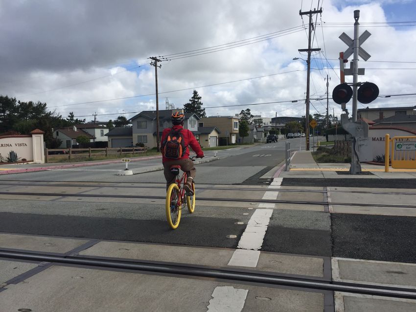
January 23, 2022 Page 17City of Millbrae Active Transportation Plan – Final
US 101/Millbrae Avenue Interchange. US 101 and its partial cloverleaf interchange at Millbrae Avenue
create a barrier for pedestrian access to the San Francisco Bay and to walking between the hotels on the
east side of the interchange and Millbrae services and amenities to the west. Sidewalks and crosswalks are
limited at the interchange and along Millbrae Avenue between the interchange and Bayfront Park. Like El
Camino Real, the interchange is under Caltrans jurisdiction and will require any improvements across US 101
to proceed through the Caltrans project development process.
Rail Lines. The Caltrain and BART rail lines are barriers for pedestrian travel. They restrict east-west access
from the Bayside Manor Subdivision and Marina Vista Subdivision, which are east of the tracks and west of
US 101.
Lack of Accessible Sidewalks and Crosswalks. In the western part of the city, limited sidewalks and
crosswalks are present for pedestrians crossing the two I-280 interchanges to access the San Andreas and
Sawyer Camp Trails. Additionally, citywide there are many locations where sidewalk lifting or other
American with Disabilities Act (ADA) barriers (e.g., poles reducing the clear width of the sidewalk) limit
walking connectivity for people who use wheelchairs, walkers, or with disabilities that limit their mobility.
Accessibility improvements are traditionally handled through an ADA Transition Plan, routine maintenance,
or as projects are implemented in the vicinity.
Grade. Steep changes in grade can be a barrier for pedestrian activity in neighborhoods in the western
part of the city.
BICYCLIST AND PEDESTRIAN COUNTS
Bicyclist and pedestrian counts were collected at key intersections on a weekday during the AM and PM peak
hours. The bicyclist and pedestrian volumes are presented on Figures 4 and 5, respectively. As shown on Figure
4, there are high concentrations of bicyclists in the southwestern portion of the city adjacent to I-280 and in the
northeastern portion of the city along the San Francisco Bay. This is likely due to bicyclists accessing the San
Andreas Trail and Sawyer Camp Trail to the west and the Bay Trail to the east. There is also some concentration
of bicyclists in downtown Millbrae and along El Camino Real.
As shown on Figure 5, there are high concentrations of pedestrians in downtown Millbrae and along El Camino
Real. This is likely due to the more walkable characteristics of these areas and the presence of key destinations,
such as governmental/institutional uses, schools, commercial uses, and transit stops.
January 23, 2022 Page 18Figure 4: Peak Period Bicyclist Counts
SAN BRUNO
C I T Y PA R K SA
NT
L9
8M
Lomita Park
AT
Elementary
K
ER
6L 11
PA R
TA
CY P
RE S
ES
A M School
I MARINA
º
¹
PA
OM
S SAN FRANCISCO
L V I S TA PA R K
L
SA
M
W INTERNATIONAL AIRPORT
A
IT
E
VI
RK
N
LA
NIT
O
NE
Y CE
AN
BA
N D L MO
PA
RU
RO
JU A
JUNIPERO
º
¹ R
SE
SP
IN
EL
RA
Capuchino DA
AD
BA
A
SERRA
G
CE
L6
CA
M
NIT
Y
BA
High School 7M R I NE
M
P
AR
D TE
BO
IN
NA OO N
T
ß101
O
/
AB
W UN E
LO ILL
M
RE
C
MO SAN
ON
E
L7
M
NT
C GREEN 8
AL
E R
NO RA M FRANCISCO
TE
C
SA
RA BA HI PA AN HILLS BAY
RE
T ER
DE º Glen OaksCAMontessori
¹ PU
C
DE
M P A R K St. Dunstan's
Y
SI º School
¹
A
LU
AR T
CO
D
K N
L2
D
G U AS
JA
SS
N
BI N OO 1M LE
L8
RI
IE
6GM
Z
RE
SM
RO BAY FR ON T PA R K
CO
BR
ZO
C
D G OO D
OA
P O
L 5 BR
W A
HA
CY 4OM TE IN BAY S I D E PA R K MILLBRAE
INE
L IN
OL
K W OO
EW D
EL
D MA
61 D B29
A D
MILLBRAE
º
¹ EA LV NA
LM
FE
O SA
M
O
I
OO
M AD S AY
W
E LL
MO N
RN
SH
AY M 3E
N
G
MC D O
CU RLY
BE
Green Hills W 7
D
OR
RO TE
LE
R L
W
AV
E
AR
VE
RO
H
DE
NW
GREEN HILLS
OO D
BE R
RY Elementary
IAD
LA
DO
X
B
BU COUNTRY C LUB Y
O
RT
ST
D
LA
AR
UR
School LEN
O
O
N E
R
BR
R
BA R
EL
HE
HE
L1
2M ND LI
12M 9 12ILM7
LC
Meadows L L EN
M
HE
MO E
LO
UR AL H RD
CHL 2
N
M
Elementary School SP L
RI2 M GA
C
E SD
RY
A
K
ºEH
¹
Y
A
LA R HA
K
RO
G
F IN IT
LA
N
EE N 0LL 6
N
C AN A
R GR MI
O
N
RC
LL
OL M
LI
UR EVE
L3
IN
A
BA
NC AN
SE
S 5M IA
S
T I
L
OR RI
RR
OR
C E N TR A L PA R K CT AD
LI O N S PA R K
A
VI
YL
MILLBRAE
PO
SY
TIO GA
TA
PA
PL
º Taylor Middle
¹
EL
AH WA
C
L
AM
W
AR
Intermodal Transportation Station:
M
DE
LE
IL
O BER
School
LO
R
R
K SH
W
E IR E CA MI NO AL 7LM 4
BART/Caltrain/Future HSR
H N EE
LA
IS
E
W
NE TO
RN O
N
L1
UR
M
HA
0M U E IS
EL
LU AV
17M BO H
EL
DU
M
Z
7L O EL E C
CA
AD
EL
TU A R
AS
ON BO U
CH BR
MI
EL
T
PI
NI M
þ
∙82
HT
L
DE
NO
TO IL
TA
PA
L 0
ON
D N M
RA
N
1M
RC
S
EL SPUR TRAIL Mills High
EO
I G
A
RF ST
A
PA R K º
¹
HA
4L 11
A School
VI
CR
E NC
CL MA M L 7
E
CO
N L A JOSEPHINE 3M
ST
N O
CA I VI E W A U G H / S O R O P T I M I S T
L
VI
OR
A VI A ID
EW
PA R K
§
¦M
¨ 280
TA
N ND
LE 4
HE W
4SM
AD
TO RE
VI S
MAPLE
ER A P Q
OS
ALT
V E E U
RI 18L
SP
RA
O
OR
L 20 IA VI L L A G E PA R K
OL
RI
L CA M
AU
NG
SAN ANDREAS S AR
O
LAKE DE
TE C
º
¹ Spring Valley School
MA
VA
N EL
RA N AD LA
LE
L
TA G LAGUNA
ON
LE
VI S B A
27 RO KE PA R K
21
M
L
Y
PI N
LA
RAY PAR K
SK
LO
A
IT
YL
YO
MILLBRAE AVE
N
A
IN
ZA
ER
A
LA
E
AM Period PM Period
IN
N
Millbrae City Limits
AD
A
BL
C
M
M
O
EN
N
VD
TOY O
SE
J
MILLS
NE
BA
E S TAT E
0-5 0-5 Recreation (Includes Parks)
CO
ST
PA R K
L M
IA
N BURLINGAME
N
UE
LA S
6 - 10 6 - 10
SAN MATEO COUNTY
L M
VA
RA
11 - 15 11 - 15
L LE
NT
E
L M
JO
O
FR
L 16 - 30 M 16 - 29
MILLS
CANYON
Source: Kittelson & Associates.
Map Date: 12/1/2021 CU E R N AVA C A
PA R K
L PA R K
31 - 61 0 0.25 0.5
Mi ¯Figure 5: Peak Period Pedestrian Counts
SAN BRUNO
C I T Y PA R K SA 93 L 112
M
NT Lomita Park
AT
Elementary
K
ER
70L 148
PA R
MI
TA
CY P
RE S
ES
A M School M A R I N A
V I S TA PA R K
º
¹ SAN FRANCISCO
PA
S
LO
L
SA
M
W INTERNATIONAL AIRPORT
A
IE
IT
N
RK
LA
NIT
YV
NE
O
CE
AN
BA
ND
PA
RU
RO
JU A
JUNIPERO
º
¹ R
SE
SP
IN
EL
DA
RA
AD
Capuchino BA
SERRA
A
G
LM
CE
29M
L 29
CA
M
NIT
Y
BA
High School I NE
O
R
M
P
AR
D TE
BO
IN
NA OO N
101
T
O
ß
/
AB
O LW UN E
M
RE
L C
EL MI MO SAN
ON
76 L 86
NT
C
AL
A FRANCISCO
AC
E R O R M
TE
RR SA BA
CH
IN PA
MA
N
BAY
RE
TE E ¹ Glen OaksCAMontessori
º PU DE
¹ St. Dunstan's
Y
ID
º
A
S LU
AR T
CO
D
OK School E N
111 M10RE S
D
G U AS
JA
S
N
BI N R O 41GL 125
RI
L L
M
IE
Z
SM
RO BAY FR ON T PA R K
CO
ZO
C
D G OO D
OA
B P O
91DO L 269
HA Y W A
C
M TE BAY S I D E PA R K MILLBRAE
INE
IN
L IN
OL
K W OO D
EW D
BR
EL
MA LVA
19 LD B183
D
EA MILLBRAE
º
¹ NA
M
FE
O SA
M
O
I
OO
M AD S AY
W
MO N ELL
RN
SH
93 239 MC D O N
G
CU
BE
W
Green Hills
M
D
OR
RO TE
L
LE
AY R
W
HE
AV
E
A
VE
RO
DE
NW
OO D
GREEN HILLS
BE R
RD
RY Elementary
I
LA
AD
RL
X
B
Y
BU COUNTRY C LUB
RT
O
O
ST
LA
AR
UR
School LEN
Y
O
O
N E
R
BR
R
BA R
EL
HE
230 M16
HE
LI
288ILL 546
C
89 150
D
Meadows L N
M
L M
L N
M
HE
MO LE DE
LO
R H
PU 146RICH 87 R
N
M
L DA
Elementary School S
LM GA
C
AE
RY
A
RK
ºEH
¹
Y
A NS
K
RO
G
F IN LA IT
LA
EE N CH N 85 L 134
N
AN A
R GR MI
M
L
O
RC
LL
OL
LI
UR EVE
118 441IA
IN
M
A
BA
NC AN
SE
S
LI L
S
T R RI
RR
OR
C E N TR A L PA R K C TO AD
LI O N S PA R K
A
VI
YL
MILLBRAE
PO
SY
TIO GA
TA
PA
PL
º Taylor Middle
¹
EL
AH WA
C
L
AM
W
AR
M
DE
LE
Intermodal Transportation Station:
IL
O BER
School
LO
R
R
K SH
W
E IR E CA MI NO AL 127 136
M
L BART/Caltrain/Future HSR
H N EE
LA
IS
W
NE TO N E N
31M
L 22 SO
UR
UM UR
HA
E
EL
I
AV
10M
L 2DUM O
L O H
EL
DB
Z
O EL C
AE
CA
EL
TU R
AS
NT BO A R U
MI CH
EL
PI
82
LB
NI M
þ
∙
HT
E TO NO IL
TA
ND
PA
18 M
L 14
ON
D M
N
A RC
S
L
IE GR SPUR TRAIL Mills High
EO
A
RF ST
A PA R K º
¹
87 26
A A School
VI CH
CR
E
CL
N LA M
AN LM 136M59
E
CO
JOSEPHINE
L
ST
N O
I IE W A U G H / S O R O P T I M I S T
A
L
V
VI
C
OR
DA VI A ID PA R K
EW
§
¦L
¨280
TA
86 SM 37
HE W
ON E N
L
AD
VI S
RT P R E
MAPLE
Q
ALT
E
OS
V A EE U
38 M17 RI L
SP
RA
R O
LO IA VI L L A G E PA R K
OL
RI
CA M
AU
AR
NG
S
O
E
TE C
º Spring Valley School
¹
MA
SAN ANDREAS EL
VA
R A ND N
AD LA
TA G LE
L
LAKE
ON
LE
VI S B A
29LM 16 RO KE LA G U N A PA R K
Y
PI N
LA
SK
RAY PAR K
LO
A
IT
YL
YO
MILLBRAE AVE
N
A
IN
ZA
R
A
LA
DE
E
IN
N
AM Period PM Period Millbrae City Limits
A
MA
BL
C
M
O
EN
N
VD
TOY O
SE
J
MILLS
NE
BA
E S TAT E
10 - 20 2 - 20
CO
Recreation (Includes Parks)
ST
PA R K L M
IA
N BURLINGAME
N
UE
SAN MATEO COUNTY LA S
L 21 - 60 M 21 - 60
VA
A
61 - 120 61 - 120
L
ER
LE
NT L M
JO
O
FR
L MILLS
121 - 240 M 121 - 240
CANYON
Source: Kittelson & Associates.
Map Date: 12/1/2021 CU E R N AVA C A
PA R K
L
PA R K
241 - 288
M 241 - 546 0 0.25 0.5
Mi ¯You can also read