Adapting to Climate Change in Coastal Monmouth County - Environmental Planning Studio Report

Page created by Virgil Kramer
 
CONTINUE READING
Adapting to Climate Change in Coastal Monmouth County - Environmental Planning Studio Report
Adapting to Climate Change
       in Coastal
         Monmouth County
Environmental Planning Studio Report

Instructor: Clinton Andrews
Spring 2012
Edward J. Bloustein School of Planning and Public Policy
Rutgers University, The State University of New Jersey
Adapting to Climate Change in Coastal Monmouth County - Environmental Planning Studio Report
2012 Environmental Planning Studio Team

                            Marcus Ferreira
                              Christine Bell
                          Katherine Nosker
                              Michael Yaffe
                          Michael D’Orazio
                                 Kyle Davis
                           Albert Macaulay
                          Zhuosi (Joyce) Lu
                             Brian Gibbons
Adapting to Climate Change in Coastal Monmouth County - Environmental Planning Studio Report
Contents
                                                                                          b. Data Collection and Methods of GIS....................29                               Highlands Fiscal Impact Analysis.............................63                  Appendices..................................................................102
                                                                                          c. Fiscal Impact Analysis Methods............................32                           Highlands Flood Models............................................64                 Works Cited................................................................103
                                                                                          d. Interviews/Stakeholders.........................................37                          Highlands Model: All Flood Events............................65                  Appendix of Reference Tables.................................109
                                                                                      Case Studies..................................................................39                    Highlands Model: 10 Year Storm Event.....................67                      Appendix: Example of Fiscal Calculations Middlteown 10 Year
                                                                                                                                                                                          Highlands Model: 50 Year Storm Event.....................69                      Storm Event................................................................115
                                                                                      Case Study 1: Sea Bright............................................40
                                                                                                                                                                                          Highlands Model: 100 Year Storm Event...................71                       Appendix: Interviews...............................................121
                                                                                          Physical Setting............................................................40
                                                                                                                                                                                          Highlands Model: 500 Year Storm Event...................73
                                                                                          History..........................................................................41                                                                                             Appendix: List of Tables, Figures, and Pictures....132
                                                                                                                                                                                     Mitigation Strategies and Recommendations.........74
                                                                                          Demographics..............................................................41
                                                                                                                                                                                 Case Study 3: Middletown........................................76
                                                                                          Master Plan Summary.................................................42
Acknowledgements.....................................................1                                                                                                               Physical Settting...........................................................76
                                                                                          Historic and Current Mitigation Strategies.............43
Executive Summary.......................................................2                                                                                                            Current Demographics...............................................80
                                                                                          Sea Bright Budget Summary......................................44
                                                                                                                                                                                     Middletown Master Plan ...........................................80
Introduction....................................................................5         Sea Bright School Budget...........................................45
                                                                                                                                                                                     Middletown Flood Models.........................................84
    a. Overview of Historical Coastal Development......5                                 Recent Tax Rate Trends...............................................45
                                                                                                                                                                                          Middletown Model: All Flood Events........................85
        Storm Events Timeline.........................................10                  Sea Bright Flood Models.............................................46                         Middletown Model: 10 Year Storm Event..................87
    b. Sea Level Rise:..........................................................12             Sea Bright Model: All Flood Events............................47                          Middletown Model: 50 Year Storm Event .................89
    c. Definition of Mitigation and Adaptation.............12                                  Sea Bright Model: 10 Year Storm Event......................49                             Middletown Model: 100 Year Storm Event................91
    d. Federal Law Overview...........................................13                       Sea Bright Model: 50 Year Storm Event......................51                             Middletown Model: 500 Year Storm Event................93
    f. Mitigation Strategies and Best Practices...............17                               Sea Bright Model: 100 Year Storm Event....................53
                                                                                                                                                                                     Mitigation Strategies and Recommendations.........94
    g. Overview of Regulatory Framework in New Jersey	 19                                      Sea Bright Model: 500 Year Storm Event....................55
                                                                                          Mitigation Strategies and Recommendations.........56
                                                                                                                                                                                 Conclusions...................................................................97
        Legal Events Timeline..........................................20                                                                                                            Mitigation SWOT Analysis: ......................................98
        Historical Events Timeline...................................26               Case Study 2: Highlands...........................................58
                                                                                                                                                                                     Fiscal Conclusions.......................................................99
                                                                                          Physical Setting............................................................58
Methods.........................................................................28                                                                                                   Specific Policy Objectives/Recommendations:......100
                                                                                          History..........................................................................58
    a. Case Studies ............................................................29                                                                                                  Additional Points of Research.................................101
                                                                                          Demographics and Land Use....................................59

 Monmouth County Coastal Hazard Mitigation
Adapting to Climate Change in Coastal Monmouth County - Environmental Planning Studio Report
Acknowledgements

                                                        The studio would like to express its gratitude for the assistance provided by the follow-
                                                        ing individuals, who volunteered their time and effort to support this studio and its final
                                                        products.

                                                        Gabrielle Barnett - Former Sea Bright Renter
                                                        Scot Bell - Sea Bright Property Owner
                                                        Dr. Cathy Folio - North Middletown Property Owner and Resident
                                                        Jason A. Greenspan, PP, ACIP - Director of Planning and Community Development,
                                                        Township of Middletown
                                                        William J. Keeler - Councilman, Borough Sea Bright
                                                        David Listokin, PhD - Professor, Bloustein School of Planning and Public Policy at Rut-
                                                        gers University, and Co-Director, Center for Urban Policy Research of Rutgers University
                                                        Dina Long - Mayor, Borough of Sea Bright
                                                        Margaret Murnane - Deputy Coordinator, Monmouth County Sheriff’s Office, Office of
                                                        Emergency Management
                                                        Norb Psuty - Professor, Coastal geomorphology, shoreline erosion, coastal zone manage-
                                                        ment
                                                        Stephanie Rinaldi - Port Monmouth, Middletown, Property Owner and Resident
                                                        Thomas A. Thomas, PP - Former Planning Consultant to Highlands, Middletown and Sea
                                                        Bright
                                                        Charles Rogers Office of Emergency Management (“OEM”) - Middletown, NJ

                                                        Sea Bright Public Library Staff
                                                        Eastern Branch of the Monmouth County Library Staff

                                                        *A special thank you to Dr. Clinton Andrews for his guidance and support throughout
                                                        the semester, as well as Judd Schechtman for his assistance with national and state legis-
                                                        lation and conduction of interviews.
Highlands House Construction
Credit: ScotMonmouth
             K. Bell County Coastal Hazard Mitigation
                                                                                                                                                      1
Adapting to Climate Change in Coastal Monmouth County - Environmental Planning Studio Report
and the nation at large. In the past, without significant state      that are 50% or more damaged by storms) would not be

    Executive Summary
                                                                                                                                      and federal aid, after having dune-side cottages repeatedly          rebuilt. This scenario also assumes that FEMA would pick
                                                                                                                                      leveled by storms in the 1890’s the wealthy owners of Sea            up 75% of debris removal costs. The Smaller Subsidy sce-
                                                                                                                                      Bright cottages opted for the only choice that the free mar-         nario assumes that half of all substantially damaged prop-
                                                                                                                                      ket would allow: Inland relocation. Now ironically, those            erties would rebuild. This scenario assumes that FEMA
                                                                     cally and in population that trebled in population follow-       who seek continual aid for beach replenishment, sea wall             would only pay 25% of debris removal costs, leaving towns
                                                                     ing of the construction of the New Jersey Parkway in the         fortification and flood insurance policies that no private           with 75% of these costs. This scenario was formulated to
                                                                     1950’s. The inland portions of the town suffer from typical      insurance actuary would issue—argue that government is               demonstrate what would happen if FEMA made the policy
                                                                     suburban sprawl characteristics that impede the ability of       imposing increasingly undue regulations on land develop-             decision to provide less support to coastal towns. The fol-
    Coastlines are ever evolving, buffeted by the wind and
                                                                     the riverine floodplains from fully performing their natu-       ment in exchange for these sums.                                     lowing explains how each town fared for these storms and
    waves, and drifting with the currents. Often, the evolution
                                                                     ral functions. The coastal portions of the town include the      The historical sections of this report detail seemingly ad           scenarios:
    is gradual, seemingly imperceptible. However, occasion-
                                                                     fishing port of Belford and other densely populated areas        nauseum how these towns have been historically battered              •       Highlands -Based on the fiscal impact analysis of 10,
    ally, the evolution is accelerated by the onset of storms,
                                                                     (Navesink, Leonardo and Fort Monmouth), subject to both          by the sea, dating as far back as the 17th century—prior to          50, 100, and 500 year storms for the Rebuild, Retreat, and
    which can eliminate islands, carve inlets into barrier beach-
                                                                     coastal and riverine flooding. Here Jetties were built to        significant influence on humanity on climate change. The             Smaller Subsidy scenarios, Highlands consistently performs
    es and completely flood low lying areas. In the New Jersey,
                                                                     protect the port and more recently, the New Jersey DEP has       intent is not to write a history tome, rather, it is to illustrate   best in a retreat scenario. The equalized tax rate is lowest
    there are records of this changing landscape and of human-
                                                                     been hardening of the dunes to restore beaches along the         how these storms are not fluke events, and that the conse-           for the retreat scenario for each storm considered, at 1.118
    ity’s attempts to resist it—lured by the sea and clinging to
                                                                     Bayshore.                                                        quences to those who build in the coastal flood plain are            for the 10 year storm, 1.229 for the 50 year storm, 1.299 for
    real property notions of indefinite terra firma—a misplaced
    assumption on the coast. We have selected three case study       Lastly, we also chose Highlands, because it is also on the       doing so at tremendous foreseeable risk, based upon long             the 100 year storm, and .990 for the 500 year storm. Fur-
    towns in Monmouth County New Jersey to illustrate this           Bayshore, like Middletown, and is small in area like Sea         standing storm patterns found in the historical record. Our          thermore, the more severe the storm, the better the retreat
    story and to project what the future holds in the face of        Bright. However, it differs from both in that it has the         analysis then builds off this using state of the art GIS HA-         scenario performs in terms of tax rate for Highlands. In the
    climate change and its primary coastal effects: Sea level rise   highest poverty rate and geographically is bisected by the a     ZUS modeling and remote sensing LIDAR technologies to                500 year storm, the worst storm tested in this model, the
    and increased storm severity.                                    Plateau ridge that gives the town its name.                      interpret the effect of the combination of increased rates of        Retreat scenario’s tax rate was .418 lower than the Rebuild
                                                                     In New Jersey, the effects of climate change represents a        sea level rise and ever increasingly severe storms, on prop-         scenario, and .550 lower than the Smaller Subsidy scenario.
    We chose Sea Bright, a small town built on a Barrier Beach
                                                                     unique challenge because the coastal towns of New Jersey         erty damage to each of our three study towns in Monmouth             The tax rate drops substantially in the Retreat scenario for
    that has had inlets form and reform over the centuries, and
                                                                     are amongst the most densely built and populated in the          County, NJ. This model yields damage data to towns for               the 500 year storm because of the large loss of population,
    now has an imposing sea wall, built with external subsidies
                                                                     nation. However, much of this growth has been over the           various storm scenarios; in this report, we explored the             in proportion to the size of the town. More than one third of
    in 1947, and maintained to date, with external subsidies.
                                                                     past fifty years, since the construction of the Garden State     10, 50, 100, and 500 year storms. This information is then           people (34%) are lost in that scenario. This means that a far
    The Population has been relatively stable since 1910, but
                                                                     Parkway in the 1950’s, facilitating travel to the shore, at-     transferred to a fiscal model to determine the impacts these         smaller amount of people would be left to receive govern-
    the primary issue here, has been rebuilding more expensive
                                                                     tracting vacationers, partial year occupants and full time oc-   storms would have on municipal budgets based on three                mental services, thereby lowering the tax rate significantly.
    structures following storm events. Notably the sea wall
                                                                     cupants alike. In part, this has led to the rapid build-up of    scenarios: Rebuild, Retreat and Smaller Subsidy.                     The Smaller Subsidy scenario represents the worst option
    was built behind long since abandoned cottages formerly
                                                                     the New Jersey shore, which in all areas is within two hours     The Rebuild scenario assumed that all properties damaged             for Highlands, as it consistently has the highest tax rates
    built on dunes and on a former railroad right of way that
                                                                     of either the New York and/or Philadelphia metropolitan          in the storm events would rebuild, as history tells us they          for all storms at 1.189 for the 10 year storm, 1.361 for the 50
    was abandoned following repeated storms. This retreat
                                                                     centers.                                                         will. This scenario also assumed that the Federal Emergen-           year storm, 1.494 for the 100 year storm, and 1.541 for the
    was inevitable due to the impossibility of continually fi-
                                                                     Federal and state decision making since the Ash Wednes-          cy Management Agency (FEMA) would pay 75% of debris                  500 year storm.
    nancing rebuilding with local monies (even by wealthy
    cottage owners). This was the free market operating at its       day Storm of 1962 has subsidized development in coastal          removal costs, which they currently do, leaving towns with           •       Middletown - In general, based on the fiscal impact
    purest.                                                          regions, through shifting the cost of fortification, beach re-   25% of these costs. The Retreat scenario assumes that all            analysis of 10, 50, 100, and 500 year storms for the Rebuild,
                                                                     plenishment and flood insurance from the locals to the state     of the substantially damaged buildings (ie those buildings           Retreat, and Smaller Subsidy scenarios, the tax rate in-
    We chose Middletown, a much larger town geographi-
2   Monmouth County Coastal Hazard Mitigation                                                                                                                                                                                                                                3
Adapting to Climate Change in Coastal Monmouth County - Environmental Planning Studio Report
creased in all scenarios, and the worse the storm is, the        ed by the storms because of its size and smaller percentage
    higher the tax rate grows. The Municipality of Middletown of homes and buildings being located on the coast.

                                                                                                                                   Introduction
    consistently performs best in a retreat scenario. The equal-
    ized tax rate is lowest for the retreat scenario for each storm
                                                                                                                                                                                                  over them. The settlement spread out and salt marsh
    considered, with an increase of 6% for 10 year Storm, 8% for
                                                                                                                                                                                                  ceased to be so much sought after as upland meadows were
    50 year Storm, and roughly 10% for 100 year and 500 year
                                                                                                                                                                                                  cleared and drained (Mandeville, 1972, pp. 30, 48).”
    Strom. Furthermore, the more severe the storm, the better
    the retreat scenario performs in terms of tax rate for Mid-
    dletown. The Smaller Subsidy scenario represents the worst                                                                                                                                    Middletown’s coastline has long been changing through its
    option for Middletown, as it consistently has the highest                                                                      a. Overview of Historical Coastal                              interactions with wind and water. It is important to note in
                                                                                                                                                                                                  that the coastline is ever evolving, and attempts to keep the
    tax rates for all storms. This is due to the high cost of debris
    removal. The most significant jump of tax rate occurs on the                                                                   Development                                                    shore static is not only contrary to natural processes, it is
    500 year storm, which is about 28% tax rate increase. This                                                                                                                                    very expensive (requiring billions in state and federal sub-
    is also the only one that exceeds 0.6 in all scenarios for all                                                                                                                                sidies to date) and yet the effort is potentially futile particu-
                                                                                                                                   Middletown, “The oldest settlement in New Jersey,” was         larly in light of projected sea level rise and more powerful
    storms.                                                                                                                        first settled by the Lenni-Lanapé Indians, and then by Euro-   storms projected in the future as a result of climate change.
    •       Sea Bright - The scenario providing the most consis-                                                                   peans Dutch traders as early as 1613. The first documented
    tently low tax rates is the retreat scenario. This is because                                                                                                                                 As early as 1529 Sandy Hook (part of Middletown), was
                                                                                                                                   verification of habitation was in 1626, with fifty families
    of the large assessed value in Sea Bright as well as the small                                                                                                                                mapped in the wake of Verranzano’s explorations. At this
                                                                                                                                   residing there by the 1650’s(Mandeville, 1972, p. 35). In
    population. Seasonal homes, which make up 25% of the                                                                                                                                          time it was a solid land extension from the Highlands.
                                                                                                                                   April 1665, Governor Nicolls deeded twelve of his English
    housing stock in the town, act as ratables and help offset                                                                                                                                    From that point southward there was no fully formed
                                                                                                                                   subjects the area now known as Monmouth County, “ .
    any loss in assessed value during the 10, 50, 100, and 500                                                                                                                                    barrier island, with both Shrewsbury Rivers feeding di-
                                                                                                                                   . . extending from Sandy Hook to the mouth of the Rari-
    year storms. The large decreases in population of residents                                                                                                                                   rectly out into the open ocean. According to a map made
                                                                                                                                   tan River, up the river approximately twenty-five miles,
    and workers also helps significantly decrease the amount                                                                                                                                      between 1683 and 1685, the barrier island that is now cur-
                                                                                                                                   then southwest to Barnegat Bay. The area was first known
    of municipal services needed. The smaller subsidy scenario                                                                                                                                    rently known as Sea Bright was then a still forming barrier
                                                                                                                                   as Navesink, then Middletown and Shrewsbury County,
    consistently produces the highest tax rates due to the high                                                                                                                                   beach submerged underwater during high tides (Methot,
                                                                                                                                   and finally in 1683 as Monmouth County (Klett, 2008).”
    cost of debris removal. And the rebuild scenario, most                                                                                                                                        Up & Down the River, 1980). A 1685 survey of Sandy Hook
                                                                                                                                   In the 17th century, a single tract of land was granted to
    consistent with the type of activity seen today, produces                                                                                                                                     reveals that it was only a quarter of its size in 1927(Man-
                                                                                                                                   Eliakim Wardell, of what is now known as Sea Bright and
    increased tax rates linearly. Since it is not affected by loss                                                                                                                                deville, 1972).
                                                                                                                                   Monmouth Beach (Methot, Up & Down the River, 1980).
    of tax revenue, the revenue never increases or decreases.                                                                      Richard Hartshorne, who resided in Middletown and was
    Instead the expenditures steadily increase by the amplified                                                                    owner of Sandy Hook, in a letter written in 1675, described    Robert Harthorne’s diary entry in 1756 noted that as a
    intensity and damage of the storms.                                                                                            Middletown’s landscape as follows: “. . . The naturale Grass   result of a January storm, an inlet opened through the bar-
    The three case studies for the most part show similar                                                                          of the country is much like that which grows in the Woods      rier beach opposite the Shrewsbury River. A diary entry
    trends. However certain municipalities are more affected by                                                                    of England, which is food enough for our cattle, but by        the following year noted that a second inlet was formed
    the storms. Highlands’ budget and tax rate is the most vul-                                                                    the water side we have fresh meadows and salt marshes. .       as a result of a storm in January 1757. In January 1778, the
    nerable with largest percent changes in the tax rate after all                                                                 .” However, from 1665 to 1700 the English settlers started     British Army’s engineers had to create a bridge to enable
    four storm scenarios. Sea Bright is the second most vulner-                                                                    altering the town’s natural environment: “. . . the forests    the army’s retreat to Sandy Hook, which prior to the 1757
    able due to its small population. Middletown is least affect-                                                                  gradually receded. Roads for cars and wagons were laid         storm had been connected to Highlands. (Methot, Up &

4   Monmouth County Coastal Hazard Mitigation                                                                                                                                                                                                                         5
Adapting to Climate Change in Coastal Monmouth County - Environmental Planning Studio Report
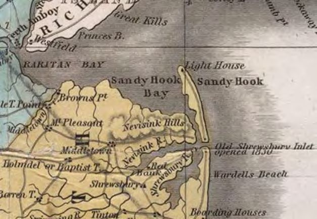
“Up and Down the River”, revealed that in 1883 the nearby                14, 1896: “The ocean washed over the beach to the river
                                                                                                                                              dunes were twice the height of the men, showing that there               in many places between Highland Beach and Seabright.
                                                                                                                                              were some natural defenses that had not been denuded                     Ocean Avenue was flooded to such an extent that it could
                                                                                                                                              (Methot, 1980). On January 5, 1889 a storm struck the area,              be navigated by boat (Methot, 1980, 59).” At Sea Bright
                                                                                                                                              causing much damage to recently developed areas. The                     a “sea wall” comprising giant piled rocks was destroyed.
                                                                                                                                              effects of the storm’s fury was captured in a vintage Phila-             “The Octagon Hotel was damaged and an owner of two
                                                                                                                                              delphia newspaper article:                                               properties lost one house that went adrift into the ocean
                                                                                                                                                                                                                       and the other was taken by the Shrewsbury river, and was
                                                                                                                                                 Long Branch, N.J., Jan. 6—The storm which began yesterday raged       found drifting with the tide (Methot 1988, 110). At High-
                                                                                                                                                 with great severity all night and did much damage along the coast     land Beach, the damage was quite extensive. A broad inlet
                                                                                                                                                 in this vicinity. The greatest damage was at that portion of Mon-     was cut five to six feet deep opposite the head of Island
                                                                                                                                                 mouth Beach Between Seabright and St. Peters in Galilee, the costly
                                                                                                                                                                                                                       Beach; “through the beach from the ocean to the river . . .
                                                                                                                                                 protestant Episcopal Church on the Beach. Here the sea tore out
                                                                                                                                                 nearly every bulkhead and washed up under several of the cot-         The ocean was rushing through this inlet at a great rate last
                                                                                                                                                 tages. The surf demolished the bulkhead of the cottage of A.T.        night (Methot, 1980, 59).”
                                                                                                                                                 Keasby, ex-United States Attorney of Newark; cut a big hole in the
                                                                                                                                                 handsome lawn, and knocked to pieces one of the brick piers which
                                                                                                                                                 supported the building. The three cottages of Richard DeGray,                 The storms that befell the area on Christmas of 1913
                                                                                                                                                 of New York, which were undermined by the storm of November           and January 1914 changed coastal development patterns,
                     Figure 1. 1826 New Jersey Map Section                                  Figure 2. 1834 New Jersey Map Section                27 escaped damage, but the partly reconstructed bulkheads were        until state and federal subsidies made it attractive to build
                Source: http://mapmaker.rutgers.edu/NJ_1826.jpg                        Source: http://mapmaker.rutgers.edu/NJ_1834.gif           knocked to pieces by the angry waters (Special Dispatch to The        in coastal flood zones again. The 1913 Christmas storm
                                                                                                                                                 North American, 1889).                                                caused “[d]amage was heavy all along the coast but it was
                                                                                                                                                                                                                       particularly severe at Sea Bright. Many of the wooden
    Down the River, 1980). An illustration of the ever evolving     “washed out” at Sea Bright by storms, that also damaged                   A storm in September of the same year, washed out track
                                                                                                                                                                                                                       bulkheads were breached and holes cut deep into the lawns
    coastline can be seen by comparing an 1826 map with a por-      wooden bulkheads and cut deeply into lawns (Methot,                       between Long Branch and Sea Bright, undermined a num-
                                                                                                                                                                                                                       behind them (Methot 1988).” “Further, The Octagon [H]
    tion of an 1834 map on the next page, showing how the Old       1988, 110). Despite these storms, Highlands Beach, literally              ber of houses that fell into the ocean, cut a new inlet below
                                                                                                                                                                                                                       otel was badly damaged in the storm Christmas night. It
    Shrewsbury Inlet reopened in 1830 between Sea Bright and        only thirty years in existence, already was bounded by three              Highlands and covered tracks with 2-5 feet of sand (Methot,
                                                                                                                                                                                                                       was undermined and the bulkhead in front of it was partly
    Sandy Hook, making Sandy hook an island again.                  hotels, a steamboat landing, Thomson’s Pavilion, Swift                    1980). This led to the first instance of tactical retreat from
                                                                                                                                                                                                                       swept away (Methot, 1980).” As a result of the January
                                                                    House and East View (Methot, 1988, 122).                                  the coast. Kobbé [Gustave] noted: “The Monmouth Beach
                                                                                                                                                                                                                       1914 storm, June Methot observed:
                                                                                                                                              Association having been able to procure the removal of the
            However, in approximately 1850, as a result of                                                                                    railroad from its old bed along the bluff to its present site,
    storms, the Shrewsbury Inlet again re-closed, reconnecting         Sea Bright was a classic example of how not to develop a beach.                                                                                    “This disastrous storm marked the end of a summer lifestyle of
                                                                       Although it was spectacular for a while, most of the early cottages    secured a continuous drive for eight miles along the ocean
    Sandy Hook to Sea Bright and forming what came to be                                                                                                                                                                  elegance and grandeur which will never be re-created. The sea
                                                                       have been relocated or long since been demolished by the sea. The      from Sea Bright to Elberon. The “present site” was a block                  had won, and the survivors knew it. Some buildings were moved
    known as Highland Beach (Methot, Up & Down the Beach,              beautiful natural scenery of this young beach, which had only sol-     further inland and it is safe to assume that the railroad was               away from the surf; some to the opposite side of the strip. Others,
    1988, p. 122). In 1865, within fifteen years of the inlet re-      idly closed itself about thirty years earlier was completely leveled   delighted to move back from the surf where they had fre-                    including some very large cottages, were barged across the river to
    closing, the Long Branch and Seashore Railroad was com-            and uncountable yards of topsoil carted over from the mainland         quently been washed out (Methot, 1988, 122).”                               the bluff, including the original Octagon cottage. Others remained
    pleted and in 1870, the first drawbridge was built between         and spread. Large and elegant cottages, some of them by any defi-                                                                                  where they were and through the 20’s and 30’s one to two more fell
    Sea Bright and Rumson (Methot, 1980). In 1880 and again            nition, mansions, were built along the beach behind flimsy wooden                                                                                  prey to the sea in every major storm.” (Methot 1980)
    in 1885, the tracks of the rail lines into Sandy Hook were
                                                                       bulkheads and landscaped with grass and gardens. The properties               In spite of the destruction, most cottage owners
                                                                       extended from the ocean to the river . . . (Methot, 1988, 110).        opted to rebuild, only to be battered by a storm on October              In the 1920’s the rail line was removed, with the currently
                                                                    However, a photograph of a fishermen in June Methot’s
6   Monmouth County Coastal Hazard Mitigation                                                                                                                                                                                                                                                   7
Adapting to Climate Change in Coastal Monmouth County - Environmental Planning Studio Report
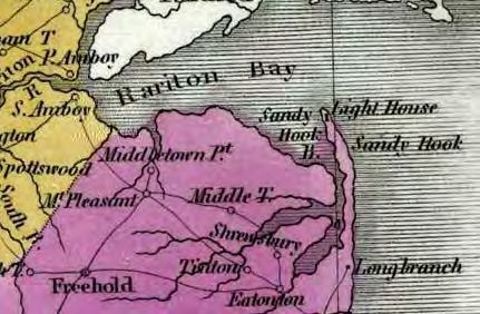
existing seawall covering the right of way. In April of 1929                                                                                missed opportunity, as presciently noted by a New York                            The federal shore protection projects have continued
    The New York Times reported further devastation to coastal June Methot provided a firsthand observation of the 1944                         Times journalist in 1963:                                                  unabated, despite the continued onset of the sea. In 1982,
    Monmouth County, citing wind speeds of 60 mph at Sandy hurricane of 1944 from her childhood home on the northern                                                                                                       a storm destroyed large areas of dunes and the eastern
    Hook:                                                                     bank of the North Shrewsbury River: “The shrieking winds             A state plan to purchase large tracts of beachfront that had been       lane of the access road in Sandy Hook. The government
                                                                              roared for 12 hours and reached speeds of 100 m.p.h.” The            denuded by the storms and transform them into public park and           re-pumped the sand back into the area and planted dune
        “The High tide inundated the shore between Long Branch, NJ., and river was 30’ above the normal high tide line. “Not until                 bathing areas under its Green Acres program never materialized.         grass. By 1988, nearly all of it had eroded away, even with-
                                                                              morning did we discover that a sturdy 100—foot dock, 50              The result has been a seemingly large scale program of rebuilding
        Atlantic Highlands, for distances ranges from forty to seventy feet.,                                                                                                                                              out a major storm event (Methot, 1988, 169).
        the flood being from two to four feet deep , and disrupted train ser- to 60 feet of solid concrete bulkhead and one-third of our           almost to the water’s edge at the high water line in areas obviously
        vice between the two towns. . . . Commuters were forced to travel                                                                          unprotected by dunes, bulkheads or sea walls. While permitting
                                                                              riverbank had vanished (Methot, 1988).” Following this               this, many communities have altered their local building codes                  The December 11, 1992 Nor’easter was the worst
        by bus or motor to Long Branch, Seabright, Monmouth and other
        intermediate towns. . . . many houses were flooded all along the
                                                                              storm, a $703,000 seawall was built on the former rail right         in recent months to force the installation of more secure founda-       storm to hit the area since the 1962 Ash Wednesday storm
        shore, at Point pleasant, Asbury Park, Seabright, Belford and Mon-    of way, funded jointly by New Jersey, Monmouth County                tions and pilings so the new structures will have a better chance of
                                                                                                                                                                                                                           and required the evacuation of 19,000 area residents, with
        mouth. Some principle highways were made impassable, either by        and Sea Bright. Residents, now feeling safer from flooding           weathering future severe storms.
                                                                                                                                                   Although the work done by the Corps of engineers has provided           seas 12-18’ elevated with the morning high tide, causing
        flood waters or drifting sand.” (The New York Times, 1929)            waters then began spending more money improving their                barriers against rough seas, it is considered insufficient to protect   two breaks through Sea Bright’s sea wall (Methot 1980).
                                                                              homes (Methot, 1980).                                                many shore properties form damage, should a storm similar to            State officials reported preliminary estimates of more than
    In 1934 and 1935 Monmouth County was struck again:                                                                                             that of 1962 again strike the coast. Adequate long-range protection     $76.5 million in damage to public facilities and the costs
             Keansburg, Belford, Atlantic Highlands, Sea Bright                                                                                    would require the expenditure of many more millions of dollars. . . .
                                                                              The next major storm was the “Storm of the Century”, a.k.a.                                                                                  of various emergency measures, with damages to private
    and Monmouth Beach were reported flooded. “In some                                                                                             About $40,000,000 of the reconstruction funds was spent on pub-
                                                                              The Great Ash Wednesday Storm of 1962, which marked                  lic facilities. Of this amount, Washington furnished $18,000,000        property in the hundreds of millions of dollars (Sherman,
    places, including Highlands, fishing boats were washed
                                                                              an opportunity for changing coastal development patterns,            through grants-in aid and the state a similar amount, most of it on a   1992). Statewide, 3,200 homes were damaged, with over
    ashore and pleasure craft were damaged. In others, sea-
                                                                              born out of colossal destruction. The Red Bank Register              matching fund basis.”                                                   2/3 of them located in Monmouth and Ocean counties.
    front cottages were reported undermined by the water and                                                                                       (The New York Times ,1963)
                                                                              noted that President Kennedy declared the New Jersey                                                                                         However, stricter building codes guarded against even
    in danger of falling into the sea.” (The New York Times,                                                                                    The Philadelphia Inquirer noted in a fifty year retrospective
                                                                              Coast a federal disaster area and that locally there was                                                                                     worse building damage totals to those buildings construct-
    1935).” Of the storms of the 1920’s and ‘30’s, in 1988 histo-                                                                               piece on the storm of 1962, again reflected on how the 1962
                                                                              $6 million in damage to public facilities, which would be                                                                                    ed since the 1962 Ash Wednesday Storm:
    rian June Methot quoted an unidentified man, old enough                                                                                     storm represented a missed opportunity, with resulting
                                                                              covered by $2.5 million available immediately for grants to
    to remember:                                                                                                                                policies perversely leading to an unprecedented building
                                                                              counties and municipalities by the state with the remaining                                                                                     If any good news came out of the [1992] storm that bruised the
                                                                              $3.5 million sought from federal Government by Governor           boom:                                                                         region’s coastline two weekends ago, it was the general success of
        “Nothing braved the fall storms in those days except the wooden       Hughes. Far more damage was wrought to private prop-                                                                                            houses constructed under strict building codes to withstand high
        sides of those grand, summer mansions that graced that slip of land                                                                                                                                                   winds and surging tides, Federal and local government officials say.
        between Sea Bright and Monmouth Beach. Great, breath-holding
                                                                              erty: “Worst Loss yard for yard, [were] the losses in Sea            Far from discouraging building on the beach, since 1962 the federal
                                                                                                                                                   government has inadvertently bucked up development by subsi-               Moreover, pressures from environmentalists in some beach com-
        times, then. You didn’t watch the surf spray over the rocks of the    Bright and Monmouth Beach. . .” (The Red Bank Register,                                                                                         munities that forced new housing to be set far behind existing dune
                                                                                                                                                   dizing beachfill and flood insurance, and committing billions in
        Sea Bright Sea wall and possibly flood the streets. Instead, you      1962).                                                               disaster assistance for storm recovery.                                    lines spared those structures heavy damage when the storm swept
        gasped as each storm wave peeled at the beach houses – sending                                                                                                                                                        the dunes away.
                                                                                                                                                   Well more than 90 percent of all federal shore-protection projects
        porches trim and shutters flying in a bleach of sea foam. The real                                                                                                                                                    “It takes a storm like this to make believers of a lot of people who
                                                                                  Following the storm, NJ Senator Clifford Case argued for         since 1922 have occurred in the last 50 years, according to data
        prize was to be in view when one of those grand ladies went out                                                                                                                                                       resisted these regulations when they were introduced,” said Robert
                                                                                                                                                   assembled by Western Carolina University researcher Andrew S.
        to sea – a house doesn’t really “go out” to sea. The sea literally        the creation of a federal insurance program to cover $45                                                                                    A. McCullough, director of construction inspection for Ocean
                                                                                                                                                   Coburn.
        explodes it – the northeast waves would roar beneath the stilted          million in estimated private losses in NJ, of which private      The measures have contributed to an unprecedented building boom            County, where the storm pounded barrier beaches and flooded
        hours, building a pressure underneath with each surge until the           insurers would cover only a small amount (Associated                                                                                        coastal towns for more than three days.
                                                                                                                                                   and run-up in land prices. Real estate values in the coastal towns
        roof would explode from the pressure with a geyser of salt water –                                                                                                                                                         (New York Times, 1992).
        shoot into the air – and all the sides would fall in upon themselves.
                                                                                  Press, 1962). With the creation of the National Flood In-        from Barnegat Light to Cape May Point have rocketed from $1.2 bil-
                                                                                  surance Program, New Jersey’s failure to use Green Acres         lion in 1962 to almost $99 billion today.
        At its leisure, the ocean would lap the rubble and pull it out into the
                                                                                  funding to purchase devastated properties represented a              (J. L. Wood 2012)                                                          The Army Corps of Engineers, with federal funding
        surf” (Methot 1988)

8   Monmouth County Coastal Hazard Mitigation                                                                                                                                                                                                                                                        9
Adapting to Climate Change in Coastal Monmouth County - Environmental Planning Studio Report
as well as state and local shares, embarked on a massive 50-                                                                                      Jersey shoreline in the next 50 years; and tens of billions more to                                                               Some areas of beach have lost up to 15 feet of sand, barriers that once                                                             U.S. Sen. Frank Lautenberg (D-Cliffside Park) said Thursday
     year beach replenishment project to last one year, starting                                                                                       hold sandy beaches in front of developed areas nationwide.                                                                        separated homes and businesses from the Raritan Bay. Near Keans-                                                                    [2/9/2012].(Eder, 2012)
                                                                                                                                                       (Wood, 2000)                                                                                                                      burg and Middletown, breaches in the dunes have resulted in heavy
     south of Sea Bright in 1994 and proceeding north, before                                                                                                                                                                                                                            flooding, officials said.
     replenishing the rest of the county. In the early 2000’s, the                                                                            However, even with the ongoing beach fill project, storms,                                                                                                                                                                                                                            So long as the federal and state governments continue
     project began its first round of re-nourishment:                                                                                         such as the 2010 Nor’easter send locals clamoring for even                                                                              (Spoto, 2010).                                                                                                                         to pay for beach replenishment, sea wall fortifications, and
                                                                                                                                              more federal funding:                                                                                                                           Following Hurricane Irene, “a storm surge of 3 to 5                                                                            also continues to subsidize flood insurance, we can expect
         The ongoing fill project in North Jersey represents an escalation                                                                                                                                                                                                            feet along the state’s shoreline caused moderate to severe                                                                             that coastal development will continue unabated throughout
         in the Corps’ battle with nature. At 21 miles, from Sea Bright to                                                                                                                                                                                                                                                                                                                                                   coastal New Jersey and the rest of the nation even in the face
         Manasquan, it is the largest beachfill project in the nation’s history.                                                                       After a series of winter storms devastated the 27 miles of beaches                                                             tidal flooding with extensive beach erosion.”(Nee, 2011).
         If fully funded over 50 years, the $1 billion federal share of the costs                                                                      along the Raritan and Sandy Hook bays, local officials say they                                                                Predictably, the federal bailout cycle continued: “A $24                                                                               of climate change.
         would rival the total spent in the history of the program to date.                                                                            need the federal government’s help -- now -- to shore up the dunes.                                                            million federal investment in beach replenishment, flood
         About $5 billion would be required to defend the entire developed                                                                                                                                                                                                            mitigation and storm damage reduction projects throughout
                                                                                                                                                                                                                                                                                      the New Jersey coastline will give beaches the restoration
     Storm Events Timeline                                                                                                                                                                                                                                                            they need to remain competitive during tourist season,”

               February 5, 1880
               Track of NJ Southern Railway near the Bellevue Hotel in
               Sea Bright was considerably damaged by a storm. The
               storm also damaged wooden bulkheads and deeply into
               lawns.
                                                                                                                                                                                                                                                                                                                                                                  Snow Storm
                                                                                                                                                                                                                                                                                                                                                                  February 2, 1978
                            Nor'easter
                            Feb 18, 1885                                                                                                                                                                                                                                                                                                                          A snow storm with heavy winds caused tides to be seven
                                                                                                                                                                                                                                                                                                                                                                  feet above normal levels. More than 400 Monmouth
                            Severe storm did considerable damage to Northern                                                                                                                                                                                                                                                                                      County residents were evacuated while waiting for the
                            Monmouth County area. However, winds were below                                                                                                                                                                                                                                                                                       water to retreat, including over 150 from Sea Bright and
                            65mph and most damage was caused by ice. Again, in                                                                                                                                                                                                                                                                                    Monmouth Beach.
                            Sea Bright, wooden bulkheads were damaged as well as                          January 14–15, 1914
                            lawns and the railroad.
                                                                                                          “Worst storms in history to hit area.” Damage had not                                                                                                                                                                                                                  Storm/ Wash-over in Sandy Hook
                                                                                                          been repaired from the December storms.                                                                                                                                                                                                                                1982
                                        September 11, 1889
                                                                                                          In Sea Bright- the Octagon Hotel and many houses fell into                                                                                                                                                                                                             This storm destroyed large areas of dunes and part of the
                                        The “worst storm that had ever visited Sea Bright.” At high       the ocean. After the storm, some buildings were moved                                                                                                                                                                                                                                                                                                                             Hurricane Bill
                                                                                                                                                                                                                                                                                                                                                                                 road.                                                                                                      August 22, 2009
                                        tide, all the land from the bay to the ocean was completely       further away from the ocean, others to the bayside, and
                                        covered with water. Part of the railroad track between            others barged across the river. This storm marked the
                                        Long Branch and Sea Bright washed out and a number of             end of a grand summer lifestyle.                                                                                                                                                                                                                                                March 1984                                                                                         Tropical Storm Ida
                                        houses were undermined and fell into the ocean. A new                                                                                                                                                                                                                                                                                             Causes $3million in damages and 4ft of water throughout                                            November 8–18, 2009
                                        inlet cut through the peninsula below highlands. Once the                          Various Fall Storm Events                                                                                                                                                                                                                                      the Highlands.
                                        water receded, the rail tracks were covered with 2-5 feet                                                                                                                                                                                                     The Ash Wednesday Storm                                                                                                                                                                An offshore tropical storm caused massage beach
                                        of sand.                                                                           1920 – 1940                                                                                                                                                                                                                                                                                                                                                       erosion in Sea Bright and along the Jersey Shore, causing
                                                                                                                                                                                                                                                                                                      March 6–8, 1962                                                                                                       The Storm that Stole Christmas
                                                                                                                           There were a number of storms during these decades that                                                                                                                                                                                                                                                                                                           President Obama to sign a major disaster declaration.
                                                                                                                                                                                                                                                                                                                                                                                                                            December 11, 1992
                                                           Oct 14, 1896                                                    destroyed many of the grand summer mansions in Sea                                                                                                                         "The Great Atlantic Storm of 1962" A Nor'easter with
                                                                                                                           Bright. In each storm, ocean water sprayed across the                                                                                                                      devastation so alarming that the federal government                                                                   A Nor’easter caused massive damage in the area.                   Nor'easter
                                                           During a storm event waves washed from the ocean to the                                                                                                                                                                                                                                                                                                          Hurricane force winds of 77mph, along with 4in of rain in
                                                                                                                           seawall and washed many homes away.                                                                                                                                        considered barring development from barrier islands.                                                                                                                                    March 2010
                                                           river in Sea Bright, flooding Ocean Ave so badly, a boat                                                                                                                                                                                                                                                                                                          24 hours, a lunar eclipse, and a full moon created 12- 18 ft
                                                                                                                                                                                                                                                                                                      Highlands was devastated.
                                                           could travel on it. This storm also destroyed a “seawall”                                                                                                                                                                                                                                                                                                        seas with the morning high tide (9 ft over mean low water in      Flooding occured throughout Middletown and left the
                                                           and damaged the Octagon Hotel, and two houses. In the                                                                                                                                                                                                                                                                                                            ocean, 10 1/2 in bays). 19,000 people were evacuated              Leonardo 9/11 memorial in a pile of rubble. In Sea Bright,
                                                           north end of town, an inlet was cut through from the ocean                                     1932                                                                                                                                                                                                Ice                                                           from Highlands, Sea Bright, Monmouth Beach, Union                 severe flooding on most streets occurred throughout the
                                                           to the river, just south of Sandy Hook.                                                                                                                                                                                                                                                            January 1977                                                  Beach, Middletown, and Dover. 3,200 homes were                    town from the overflowing Shrewbury River.
                                                                                                                                                          Highlands is battered by a fierce storm bringing 2ft of
                                                                                                                                                          flood water onto all of Bay Avenue.                                                                                                                                                                  Extensive ice breaks docks, piers, and boat slips with        damaged statewide, over 2/3 of which were in Monmouth
                                                                                                          The Christmas Storm                                                                                                                                                                                                                                 each high tide affecting Atlantic Highlands, Highlands, Sea   and Ocean Counties. The ocean broke through the Sea                   Hurricane Danielle
                                                                                                                                                                                                                                                                                                                                                              Bright, Monmouth Beach, Rumson, Fair Haven, Red               Bright seawall in 2 places and caused massive erosion                 August 29, 2010
                                                                                                          December 25–26, 1913                                                              The Great Atlantic Hurricane                                                                                                                                                                                                    along the coast, drastically changing the shoreline. Parts
                                                                                                                                                                                                                                                                                                                                                              Bank, Little Silver, and Oceanport. Governor Byrne asked
                                      Jan 7, 1889                                                         Damage was bad along the coast, but particularly severe                           September 13–14, 1944                                                                                                                                             President Carter to declare several counties federal          of the Garden State Parkway were flooded and closed.
                                                                                                                                                                                                                                                                                                                                                                                                                            Governor Florio declared a state of emergency and                     Tropical Storm Earl
                                      Water from the Shrewsbury River overflowed onto the                  in Sea Bright. Many wooden bulkheads were breached.                               Winds reached speeds of 100mph and roared for 12                                                                                                                  disaster areas.                                                                                                                     September 3, 2010
                                                                                                          The Octagon Hotel in Sea Bright was badly damaged and                                                                                                                                                                                                                                                             President Bush declared the four coastal counties a
                                      streets of Sea Bright on the west side of town, reaching                                                                                              hours. Destruction occurred throughout the area. In the                                                                                                                                                                         disaster area.
                                      depths of 4- 6ft. The ocean surf cut across the peninsula,          the bulkhead in front of it was partly swept away.                                Highlands was devastated as homes were swept from                                                                                                                                                   Hurricane Gloria                                                                                     Hurricane Irene
                                      running into the river at the north end of town.                                                                                                      their foundations and carried blocks away.                                                                                                                                                          September 27, 1985                                                                                   August 2011
                                                                                                                                                                       November 1935                                                                                                                                                                                                                                                                  Hurricane Dennis
                                                                                                                                                                                                                                                                                                                                                                                                                                                      September 6, 1999                              3- 5ft storm surge along the shore caused moderate to
                                                                              Vagabond Hurricane                                                                                                                   1953                                                                        Hurricane Donna                                                                                                          The Perfect Storm
                                                                                                                                                                                                                                                                                                                                                                                                                                                                                                     severe tidal flooding with extensive beach erosion.
                                                                              1903                                                                                           September 1938                                                                                                    1960                                                                                                                     October 31, 1991
                                                                                                                                                                                                                   A Nor'easter floods Bay Ave in the Highlands with 3 ft of                                                                                  Hurricane Belle                                                                          Hurricane Floyd                                Extensive flooding and damage inland, including road
                                                                              First hurricane to make landfall in a hundred years.                             1933          Hurricane.                            water                                                                       Highlands devastated.                                         August 1976                                                Halloween Storm               September 17, 1999                             collapses in Middletown.

                                                                                                                                                                                                                                                                              Years                                                                                                                                                                                                                                                                          Years
            1880        1885         1890           1895        1900          1905          1910         1915           1920         1925         1930         1935          1940         1945          1950        1955          1960          1965         1970                            1960            1965              1970               1975                1980               1985                1990               1995                2000                2005               2010                2015              2020               2025

10   Monmouth County Coastal Hazard Mitigation                                                                                                                                                                                                                                                                                                                                                                                                                                                                                                                       11
Adapting to Climate Change in Coastal Monmouth County - Environmental Planning Studio Report
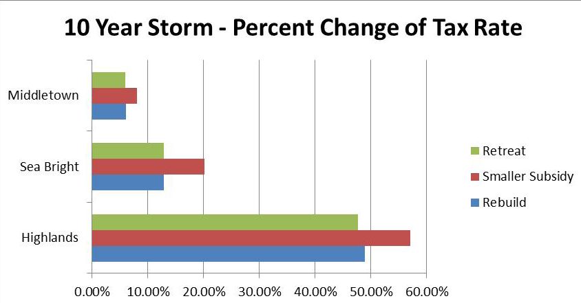
rent projections indicate substantial variability in future        tems to actual or expected climatic stimuli or their effects,
                    Figure 3. Predicted range of sea- level rise.
                                                                      sea level rise at regional and local scales; still, the IPCC has   which moderates harm or exploits beneficial opportunities       In addition, moving ‘from words to deeds’ (Smith et al.,
                                                                      concluded that the impacts are “virtually certain to be over-      (IPCC, 2012).”                                                  2009: 54) requires a number of abilities, such as being able
                                                                      whelmingly negative.” According to the IPCC, sea level                                                                             to resolve conflicting perceptions, political objectives, and
                                                                      rose 5 to 6 inches more in the last century than the global        Various types of adaptation can be distinguished, including     cultural support (Haddad, 2005; Menne and Bertollini,
                                                                      average along the Mid-Atlantic, as coastal lands there are         anticipatory, autonomous and planned adaptation:                2005; Patt and Dessai, 2005; Burch and Robinson, 2007; Fus-
                                                                      subsiding. The historic rates of median sea-level rise along                                                                       sel 2007; Nelson et al., 2007).
                                                                      the New Jersey coast range from 3-4 mm/yr and the project-
                                                                                                                                         Anticipatory adaptation is adaptation that takes place
                                                                      ed rates of median sea-level rise in New Jersey are expected                                                                       Disaster and hazard mitigation is a component of climate
                                                                                                                                         before the impacts of climate change are felt; Autonomous
                                                                      to increase to 6mm/yr (Psuty and Silveira, 2007).                                                                                  change adaptation. In practice, the definition of hazard mit-
                                                                                                                                         adaptation, also known as spontaneous adaptation, does
                                                                                                                                         not constitute a conscious response to climactic stimuli but    igation is not that different from that of climate change ad-
                                                                               Rising sea levels inundate wetlands, erode beaches,       is triggered by ecological changes and by market changes in     aptation. Hazard mitigation is defined by the Stafford Act
                                                                      and increase the vulnerability of coastal areas to flooding        human systems (Smit et al., 2000). Planned adaptation is the    as “[a]ny action taken to reduce or eliminate the long-term
                                                                      during storms. The most direct affect sea level rise has on        result of deliberate policy decisions, based on an awareness    risk to human life and property from natural hazards.”
                                                                      the coast during storm events is an overall increase in the        that conditions have changed or are about to change and
                                                                      base flood elevation. In addition to the swell in base flood       that action is required to return to, maintain or achieve a     In the process of hazard planning, strategies can be devel-
                                                                      heights, shore erosion will inevitably increase the coasts         desired state. Urban and regional systems will likely expe-     oped to alter, avert, adapt or avoid a hazard. Altering a haz-
                                                                      vulnerability to storms by removing sand from the beaches          rience all three type of adaptation as the climate changes,     ard involves eliminating or reducing the frequency of its
                                                                      and dunes that protect coastal property from storm waves.          but certainly, the spontaneous adaptive measures are likely     occurrence, such as by triggering avalanches, cloud seed-
                                                                      As sea-level rises, the effects of storms produce greater          to be very costly and disruptive. Planning adaptation is        ing or stabilizing stream banks. Averting a hazard involves
                                                                      inundations and are able to reach farther inland (Psuty            clearly much preferable.                                        redirecting the impact from a vulnerable location, such as
                                                                      and Silveira, 2007). Flooding from rainstorms may become                                                                           by constructing dikes, levees and dams. Adapting to a haz-
                                                                      worse if higher temperatures lead to increasing rainfall
     b. Sea Level Rise:                                               intensity during severe storms. Smaller storms, which were
                                                                                                                                         Adaptive capacity refers to “The combination of the             ard is defined as modifying design standards such as high
                                                                                                                                         strengths, attributes, and resources available to an individ-   wind and earthquake resistant building codes. By contrast,
                                                                      of little concern before, now may reach levels and locations                                                                       hazard avoidance is defined as keeping people away from
                                                                                                                                         ual, community, society, or organization that can be used to
     Sea level is rising along most of the coastlines around the      that were attained rarely in the past (Psuty and Silveira,                                                                         hazard areas such as through zoning laws, the purchase of
                                                                                                                                         prepare for and undertake actions to reduce adverse im-
     world. The International Panel on Climate Change (IPCC)          2007).                                                                                                                             development rights, and/or creating disincentives to build-
                                                                                                                                         pacts, moderate harm, or exploit beneficial opportunities.”
     estimates that the global average sea level will rise between                                                                                                                                       ing in hazardous areas.
     0.6 and 2 feet (0.18 to 0.59 meters) in the next century. In-
     creases in the rates of sea level raise are caused by increas-                                                                      Researchers have identified specific elements of adaptive
                                                                                                                                         capacity, such as: Availability of and access to human and
     ing global temperatures, which expand ocean water and            c. Definition of Mitigation and Ad-                                financial resources, flexible and appropriate institutions,
     melt glaciers and ice sheets. The range in projected sea level
     rise reflects the uncertainty of future global temperatures.     aptation                                                           strong networks and access to climate information (Yohe         d. Federal Law Overview
     The blue area in Figure 3 below graphically illustrates this                                                                        and Tol, 2002; O’Brien et al., 2004a; Janssen and Ostrom,
     uncertainty in the rate of sea level rise.                                                                                          2006; Smit and Wandel, 2006). Therefore, enhancing any
                                                                      As defined by the Intergovernmental Panel on Climate               of these capacities could be considered a climate change
                                                                      Change, adaptation is “adjustment in natural or human sys-         adaptation.
     Sea level is not rising uniformly around the world. Cur-                                                                                                                                            1968 The National Flood Insurance Act, 42 U.S.C.
12   Monmouth County Coastal Hazard Mitigation                                                                                                                                                                                                                            13
4001, et seq.                                                     ister the National Flood Insurance Program, 42 U.S.C.A. §        The problem is particularly acute along the Jersey Shore.       1972 Coastal Zone Management Act (“CZMA”) 16
                                                                       4011 which was an amendment enacted in 1978, signifying          3,887 properties account for half of all flood claims in the    U.S.C. §1451, et seq.
     In 1968 Congress sought to stop reimbursing people from           the beginning of FEMA’a administration of the NFIP. Ac-          state’s four coastal counties, totaling $131 million, involve
     flood losses a practice occurring since the 1962 Northeaster,     cordingly, all FEMA NFIP payouts start from 1978 and not         buildings with two or more losses, nearly one-third of the      In 1966 the Commission of Marine Science, Engineering and
     and sought to establish a national flood insurance program,       the date of the inital enactment of NFIA                         $403 million in flood claims statewide. Sixteen beach towns     Resources (“Stratton Commission”), released a study on
     placing at least some of the costs on the ratepayers. Con-                                                                         in New Jersey rank among the top communities nationwide         the conflict between development of coastal resources and
     gress recognized that:                                            However, despite good intentions, the act perversely at-         with multiple losses. Homeowners in those towns have            coastal preservation, concluding that states were in the best
     (5) the Nation cannot afford the tragic losses of life caused     tracted development in flood zones. In 2000, the Philadel-       made 7, 831 claims, totaling $88.2 million since 1978, an       position to manage coastal resources, with the federal gov-
     annually by flood occurrences, nor the increasing losses of       phia Inquirer admonished that the act was premised on            average claim of $11,262                                        ernment providing funds to help states bear the expenses
     property suffered by flood victims, most of whom are still        faulty design: “Normally, insurance rates are based on risk.      ...                                                            of administration. These recommendations were essentially
     inadequately compensated despite the provision of costly          The greater the flood risk, the more you pay. The flood          Last summer [1999], lawmakers proposed spending $200            incorporated into the regulation of land and water uses in
     disaster relief benefits; and                                     program gives huge discounts to its riskiest customers —         million more to elevate flood prone buildings. Owners           the CZMA. (Malone 1991)
     (6) it is in the public interest for persons already living in    older, flood—prone properties — while charging newer             who agree to elevate would have 75 percent of the cost paid
     flood-prone areas to have both an opportunity to purchase         properties full rates. Three of every 10 of the National         by taxpayers. Those who refuse would be charged actuarial               Per §1451(c) Congress noted in 1972 “The increasing
     flood insurance and access to more adequate limits of cov-        Flood Insurance Program’s properties are still subsidized:       rates.                                                          and competing demands upon the lands and waters of our
     erage, so that they will be indemnified, for their losses in      1.2 million properties, resulting in an average annual short-    (G. M. Wood 2000)                                               coastal zone occasioned by population growth and eco-
     the event of future flood disasters.                              fall of 450 million on those properties.” (G. M. Wood 2000)                                                                      nomic development . . . [has led to] permanent and adverse
              (b) The purpose of this Act, therefore, is to--          The Inquirer further that non-essential vacation homes                                                                           changes to ecological systems, decreasing open space for
                                                                                                                                                Since 2000, Flood Insurance Rate Maps (FIRMs) were
     (1) substantially increase the limits of coverage authorized      were offered flood insurance: “Six of every 10 National                                                                          public use, and shoreline erosion.”
                                                                                                                                        required, with those seeking federal flood insurance or
     under the national flood insurance program;                       Flood Insurance Program Properties are in beach towns,                                                                           Congress enacted a law designed to persuade, in lieu of
                                                                                                                                        disaster relief, required to participate in the Nation Flood
     (2) provide for the expeditious identification of, and the dis-   including vacation homes and investment properties on                                                                            mandating the states to protect the resources of the coastal
                                                                                                                                        insurance Program. These FIRMS were to be updated regu-
     semination of information concerning, flood-prone areas;          storm prone barrier islands. All told, $309 billion in feder-                                                                    zone via coastal management plans. An elective contractual
                                                                                                                                        larly to reflect ever increasing accuracy in flood modeling
     (3) require States or local communities, as a condition of        ally backed coastal property is at risk, including $11 billion                                                                   relationship is offered where the state can elect (or not) to
                                                                                                                                        and to reflect flood plane changes. However, despite these
     future Federal financial assistance, to participate in the        in New Jersey. Coastal areas account for a growing share                                                                         enter into an agreement with the federal government and
                                                                                                                                        improvements to the program, between 1978 and February
     flood insurance program and to adopt adequate flood plain         of the program’s most expensive claims, including seven of                                                                       the federal government for its part, can reserve the right to
                                                                                                                                        29, 2012, payouts to New Jersey totaled $1,578,747,828.22,
     ordinances with effective enforcement provisions consis-          the 10 costliest disasters. (G. M. Wood 2000)                                                                                    deem the state’s plan deficient. However, if the federal gov-
                                                                                                                                        ranking New Jersey fifth in the nation (behind four hur-
     tent with Federal standards to reduce or avoid future flood       As of 2000, repetitive loss properties represented “fewer        ricane ravaged Gulf Coast states). Of this amount, Mid-         ernment does deem the state management plan in accor-
     losses; and                                                       than 2 percent of all properties with federal flood insurance    dletown received $5,761,667.19 and Highlands received           dance with federal guidelines, the federal government will
     (4) require the purchase of flood insurance by property           yet account for nearly one-third of all losses – 200 million     $10,522,496.66. Interestingly Sea Bright received the highest   grant the state monies to effectuate the plan. (Duff 2001).
     owners who are being assisted by Federal programs or              annually. Congress has blocked attempts to impose sur-           amount of flood insurance payout subsidies, $14,903,193.01,     To qualify, a state’s management program must satisfy each
     by federally supervised, regulated, or insured agencies or        charges on the owners of these properties or to limit pay-       despite being “protected” by a seawall. (FEMA 2012). On         of the following required elements within the coastal zone
     institutions in the acquisition or improvement of land or         outs. Now it wants to use tax dollars to put some of those       December 23, 2011, President Obama signed the Fiscal Year       subject to the program:
     facilities located or to be located in identified areas having    houses on stilts, another subsidy.” (G. M. Wood 2000)            (FY) 2012 omnibus appropriations bill that includes a pro-      (A) Identify its boundaries;
     special flood hazards.                                            Nationally 96% of the 35,000 repetitive loss properties still    vision extending the NFIP through May 31, 2012. (FEMA           (B) define permissible land and water uses, having a direct
     42 U.S.C. § 4002(a) The director of the Federal Emergency         in the program remain subsidized [as of 2000].                   2012)                                                           and significant impact on coastal waters;
     Management Agency (“FEMA”) was authorized to admin-               ...                                                                                                                              (C) take and inventory and designate areas of particular

14   Monmouth County Coastal Hazard Mitigation                                                                                                                                                                                                                          15
concern;                                                            In fact, in 1984, the U.S. Supreme Court ruled against a           Further the amendments sought “to encourage the prepa-           Municipalities and the built structures within them are not
     (D) identify the means by which the State will exert control        state for failure to state a consistency objection within the      ration of special area management plans which provide            completely vulnerable to the forces of flooding, sea level
     over the land and water uses referred to in subparagraph            meaning of the CZMA. This decision led to a congressional          for increased specificity in protecting significant natural      rise, and damage brought forth by destructive storms and
     (B), providing a list of relevant State constitutional provi-       strengthening of the state’s consistency scope. (Duff 2001)        resources, reasonable coastal-dependent economic growth,         climate change. In fact, numerous strategies and practices
     sions, laws, regulations, and judicial decisions;                                                                                      improved protection of life and property in hazardous            have been proven to at least be partially effective in mitigat-
     (E) provide guidelines for use prioritization, specifiying                 In addition, the federal government has several             areas, including those areas likely to be affected by land       ing the negative effects from occurring or even preventing
     lowest priority uses;                                               exemptions from the state’s consistency provision, such as         subsidence, sea level rise, or fluctuating water levels of the   them altogether. These strategies range from altering the
                                                                         federal lands (such as Sandy Hook); any the president may          Great Lakes, and improved predictability in governmental         natural environment, altering the built environment, or
     (F) describe the organizational structure proposed to imple-
                                                                         “exempt from compliance those elements of the federal              decision making.” 16 U.S.C. §1452 (3)                            implementing increasingly restrictive building or develop-
     ment the management program, including the responsibili-
                                                                         agency activity . . . found . . . to be inconsistent with an ap-                                                                    ment codes, among others. Some geographic entities from
     ties and interrelationships of local, area wide, state, region-
                                                                         proved State program, if the President determines that the                                                                          both within the United States and abroad have already been
     al, and interstate agencies in the management process.
                                                                         activity is in the paramount interest of the United States.”       Overall effects of Federal Insurance and Laws on                 implementing some of these best practices. The hope is that
     (G) define “beach”, establishing a planning process for the
     protection of, and access to, public beaches and other pub-         Further and perhaps most importantly, the CZMA may be              Coastal Development                                              these strategies will aid in mitigating the destructive effects
                                                                         amended to increase its requirements for states to remain                                                                           associated with major storms. This is not an issue unique to
     lic coastal areas of environmental, recreational, historical,
                                                                         in the program. (Duff 2001). In fact the CZMA has been                                                                              the Jersey Shore. While the New Jersey coastline is certainly
     esthetic, ecological, or cultural value.
                                                                         amended multiple times, with perhaps the most significant                  The CZMA’s increased requirements have been              highly vulnerable, there are similar coastal developments
     (H) A planning process for energy facilities likely to be lo-                                                                          helpful, but the sheer amount of development that has been       not only up and down the American east coast, but around
     cated in, or which may significantly affect, the coastal zone,      amendments occurring in 1990. (Duff 2001)
                                                                                                                                            occurring on the New Jersey Shore, in part attracted by          the world as well.
     including a process for anticipating the management of the                                                                             NFIP subsidized loss payouts. Since 1978 FEMA’s payouts
     impacts resulting from such facilities.
                                                                         1990 Amendments, Coastal Zone Management                           have exceeded $1.5 billion in NJ (FEMA 2012). Granted, not               There are numerous methods in which humans can
     (I) A planning process for assessing the effects of, and                                                                               all of the losses are in shore towns (many are near rivers),
     studying and evaluating ways to control, or lessen the
                                                                         Act (“CZMA”) 16 U.S.C. §1451, et seq                                                                                                alter the natural environment with the mission of mitigat-
                                                                                                                                            but it goes to show that the NFIA has attracted tremen-          ing negative effects of storms in vulnerable areas. Many of
     impact of, shoreline erosion, and to restore areas adversely                                                                           dously valuable development to coastal at risk areas, which      these methods have been widely practiced both in New Jer-
     affected by such erosion.                                                                                                              would not have been built, and had not been built prior to
                                                                         In 1990, in recognition of climate change, §1451(l) was add-                                                                        sey and around the world. However, some practices have
     16 U.S.C.A. § 1455(2)(A)-(I)                                        ed, which recognized that “[b]ecause global warming may            the creation of the NFIP in 1968, given that private insur-      proven to be more environmentally conscious than others.
                                                                         result in a substantial sea level rise with serious adverse        ers refused to insure these properties from flood damage.        For example, among the most prevalently used practices
             “One aspect of the CZMA, the consistency provi-             effects in the coastal zone, coastal states must anticipate and    Improved design requirements and flood plain mapping             is beach replenishment. This method involves refilling the
     sion, allows states a voice in activities that are outside of the   plan for such an occurrence.”                                      are helpful, but are no panacea in coastal areas where the       beach of lost amounts of sand in an effort to not only make
     state territory, but which may affect the state’s coastal zone.                                                                        land gradually shifts in form, and sometimes suddenly dur-       a beach larger and more attractive but also creating more of
     Critics of the CZMA argue that the federal government                                                                                  ing major storms such as 1962 when inlets were suddenly          a protective barrier against possible flooding threats. The
                                                                         In the next section dealing with policy declaration, Con-
     bargained badly in constructing the contractual nature of           gress declared that “the study and development, in any             carved out of barrier islands.                                   method involves replacing sand that has been naturally lost
     the relationship and that the CZMA, or at least certain fea-        case in which the Secretary considers it to be appropriate,                                                                         due to erosion or drift and replacing it with sand from out-
     tures of the cooperative federalism relationship, including         of plans for addressing the adverse effects upon the coastal                                                                        side the beach area. It is a common mitigation method that
     the consistency provision, ought to be abolished. . . . But in      zone of land subsidence and of sea level rise.” 16 U.S.C.                                                                           has been funded by both public and private funds. While it
     those circumstances where the federal activity may impact           §1452 (2)(K).                                                                                                                       creates a natural, soft protection, a number of environmen-
     the state’s coastal zone, the state must do more than merely                                                                           f. Mitigation Strategies and Best                                tal issues are concerning including the harming or altera-
     object; it must articulate some rational basis for doing so.
                                                                                                                                            Practices                                                        tion of natural habitats and processes and also questions

16   Monmouth County Coastal Hazard Mitigation                                                                                                                                                                                                                                 17
You can also read