Adding Panoramas to Google Maps Using Ajax
←
→
Page content transcription
If your browser does not render page correctly, please read the page content below
Adding Panoramas to Google Maps Using Ajax

                                                 Derek Bradley
                                      Department of Computer Science
                                       University of British Columbia

                     Abstract                                  plication, adding ground-based 360-degree panorama
                                                               views of specific locations in the world. Inspired
   This project is an implementation of an Ajax web            by previous work in panorama viewing and image-
application. AJAX is a new technology based on asyn-           based navigation [2], this project investigates the added
chronous communication between a client web browser            benefit of virtually seeing the world from the view-
and a back-end server, allowing web applications to            point of a specific map location. The ground-based
request and receive data without ever reloading the            views will add value to the Google Maps functional-
page. A popular application that uses Ajax technol-            ity, which currently only supports satellite views of
ogy is Google Maps. The goal of this project is to de-         the location. Panoramic images have been captured
velop an extension of Google Maps which includes view-         at various locations around the UBC campus. An
ing 360-degree ground-based panorama images. The               Ajax application has been developed that incorporates
project includes development of a client-side Ajax en-         Google Maps with an additional panorama server and
gine and user interface in JavaScript, and development         a JavaScript front-end, providing the functionality of
of a back-end java servlet that serves panorama data           Google Maps with the addition of 360-degree ground-
and images.                                                    based panorama viewing.
                                                                  The remainder of this paper is organized as fol-
                                                               lows. Section 2 provides background details, describing
                                                               AJAX and Google Maps. In section 3 the implementa-
1   Introduction
                                                               tion of this project is described. Section 4 shares some
                                                               experiences that were encountered during development,
   One of the hottest new technologies in web-based ap-        and conclusions are given in section 5.
plication development is Asynchronous JavaScript and
XML (Ajax) [4, 7]. Ajax allows web applications to
look and feel more like desktop applications because           2     Background
data from a server can be retrieved asynchronously,
without reloading the web page. Updates appear al-                This section describes Ajax in general and provides
most immediately, which is an improvement over typi-           a brief overview of the Google Maps web application.
cal web applications which require users to wait for an
entire page to reload, even for small changes. Ajax ap-        2.1   Asynchronous JavaScript and XML
plications are driven by a client-side JavaScript engine
that communicates using XML requests with a server                Ajax is a new technology for web application devel-
in the background.                                             opment. The key idea is that communication between
   Currently, one of the biggest users of Ajax tech-           the client and the server happens asynchronously, so
nology is Google. Two Ajax applications that Google            users do not have to wait for responses and the appli-
provides are Google Suggest [6], and Google Maps [5].          cation appears to behave more interactively. This idea
Google Suggest is an interface to the Google search            is demonstrated in Figure 1, where the Ajax model is
engine that dynamically suggests terms as the user             compared to the typical synchronous web application
types, almost instantly. Google Maps is an address-            model.
based global mapping application that allows users to             Ajax is actually several technologies combined to-
zoom and drag maps around with the cursor without              gether: a backend web server, data transfer using
ever reloading the page. The goal of this project is           XML, asynchronous retrieval using XMLHttpRequest,
to implement an extension to the Google Maps ap-               dynamic HTML and a JavaScript client-side engine

                                                           1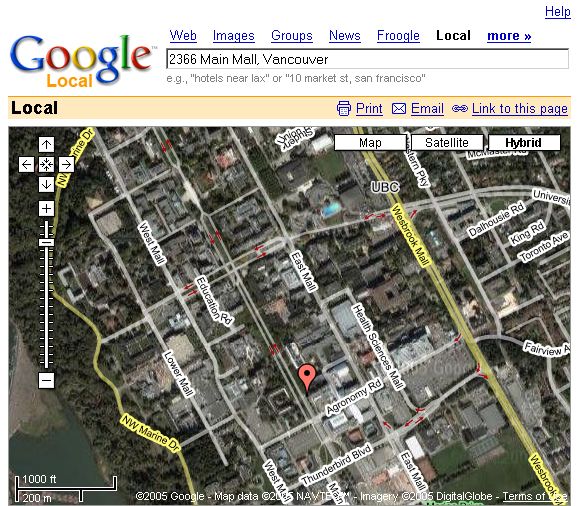
shows screenshots of Google Maps, located at the Com-
                                                                   puter Science building of the UBC campus in Vancou-
                                                                   ver.
                                                                      Google has made available an API1 for integrating
                                                                   the Google Maps functionality into other web appli-
                                                                   cations. This project makes use of the API to cre-
                                                                   ate an extended Google Maps application that includes
                                                                   ground-based 360-degree panoramic images.

                                                                   3     Google Panoramas

                                                                      This section describes the design and implementa-
                                                                   tion details of the panorama extension to the Google
                                                                   Map application.

                                                                   3.1    System Overview

                                                                      The panorama web application is designed in typical
                                                                   Ajax style with a JavaScript client-side engine running
   Figure 1. Comparing traditional synchronous                     in a web browser. The JavaScript client is described
   web applications (top) with asynchronous                        in section 3.3. In this application, there is not a sin-
   Ajax applications (bottom). (Image taken                        gle back-end server but two servers. The panorama
   from [4]).                                                      application uses the Google Maps API, so some of
                                                                   the asynchronous communication is performed with the
                                                                   Google server (to provide the standard map function-
                                                                   ality). The second server was designed as part of this
that drives the application. The JavaScript engine (or             project, and its role is to serve up the panorama data
“Ajax engine”) is a new layer that is introduced be-               and image pieces. This component, developed as a java
tween the user and the server. At the start of a session,          servlet, is described in section 3.4. An overview of the
the Ajax engine is loaded. The engine is responsible for           system is illustrated in Figure 3.
rendering the user interface and also for communicat-
ing with the server. It is this engine that provides the
asynchronous functionality of Ajax. When an XML-
HttpRequest is sent to the server it is done so in a non-
blocking manner. Control is returned to the user until
a callback function is initiated indicating the server’s
response associated with a given request. The response
is then processed by the engine without ever having to
reload the webpage.

2.2   Google Maps

   Google Maps is one of the most widely known ap-
plications of Ajax among current web applications.                               Figure 3. System overview.
Google Maps provides an address-based global map-
ping service that allows users to search for a location
anywhere in the world by address, intersection, or key-            3.2    Data Acquisition and Processing
word. Once a map is loaded users can zoom, pan inter-
actively, select points of interest, get driving directions,
                                                                      Panorama images were captured from four different
and view actual satellite images of the map location
                                                                   locations on the UBC campus. At each of the locations,
without requiring a reload. Map images are loaded
                                                                   a series of overlapping images were taken with a regular
on-demand as the user pans with the cursor, showing
off the asynchronous Ajax implementation. Figure 2                     1 http://www.google.com/apis/maps/

                                                               2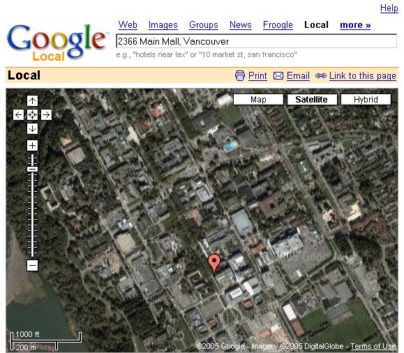
(a) (b) (c)
Figure 2. Google Map showing the CS building at UBC. (a) Regular, (b) Satellite view, (c) Hybrid view.
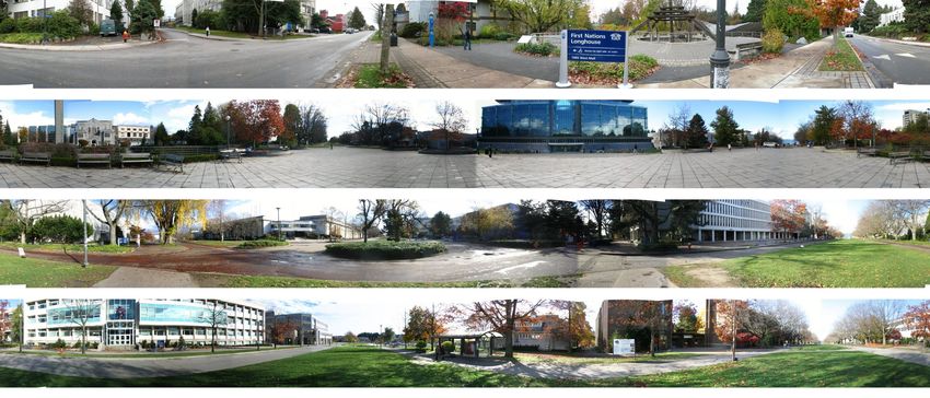
digital camera in order to capture the 360-degree field with the locations and names of all the panoramas.
of view. Approximately 12 images were captured per The associated callback function for this request parses
location, and they were stitched together in a nearly the XML response and creates markers on the Google
seamless way using the Canon PhotoStitch commercial map at the specified GPS locations. The name of
software. Figure 4 shows the final panoramic images of each panorama is also associated with the correspond-
the four locations. For each location, the Global Posi- ing marker. When the user performs a mouse-over
tioning System (GPS) coordinates were also recorded the marker, a small display window appears with the
using a standard GPS device. panorama name.
In order to maintain generality, each of the panora- The third part of the user interface is an area of
mas was resized to 4200 x 400 pixels. A small utility the screen where the panorama images are displayed.
program was then created using the Open Source Com- When a user clicks on one of the panorama markers on
puter Vision library [3] to split each panorama into sub- the map, an Ajax message is created to request the first
images of size 200 x 200 pixels. These sub-images (or four pieces of the specific panorama. In the callback
panorama pieces) are used in the Ajax web application function for this request, the XML data is parsed and
to load the panorama piece by piece on demand. the specific image source locations are loaded into im-
age place-holders on the page. This creates a panorama
3.3 JavaScript Client view window with approximately a 35-degree field of
view. Two buttons automatically appear next to the
The JavaScript client is the Ajax engine. It con- panorama view area, which allow the user to pan for-
tains a user interface using dynamic HTML, a function ward or backward within the panorama. Each pan re-
for preparing XMLHttpRequest objects, and callback quest sends another Ajax message asking for the new
functions for handling the response events. pieces of the panorama. As a new set of image pieces
On one side of the user interface is the traditional come in, the engine displays them on the page (re-
Google map, with basic controls to pan, zoom, and moving old pieces that are no longer in the field of
switch views. This part of the interface is built when view). Figure 5 shows a screenshot of the JavaScript
the page is loaded and the starting map location is client running in a web browser. The panorama im-
the UBC campus by default. The Google Maps API age pieces are loaded asynchronously, so as the user
is imported as a single JavaScript file, and the desired waits for part of the panorama to be loaded the en-
map is added to the page using a few simple calls. The gine is still processing the user’s actions. For example,
API automatically handles Ajax communication with the user can manipulate the Google map in any way
the Google server. while waiting for a panorama image to load, even if
The second component of the interface is a but- the command involves more Ajax communication with
ton called “Display Panoramas”. When this button is the Google server. This benefit is demonstrated with
pressed the engine builds an Ajax request and sends the addition of a “Continuous Pan” button on the user
it to the panorama servlet, asking for an XML file interface. When the user presses this button, the en-
3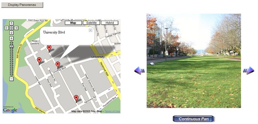
Figure 4. 360-degree panoramic images captured from around UBC campus.

gine simulates a sequence of right pan operations, one           Class                        Description
every 500 milliseconds, until the “Stop Panning” but-            LocationsRequestHandler      Request handler to serve
ton is pressed. This functionality shows the true asyn-                                       panorama location, name
chronous Ajax nature of the application, because the                                          and IDs.
user is free to manipulate the Google map and even               PanoramaRequestHandler       Request handler to serve
load new panoramas into the viewer, while it never                                            panorama image pieces.
stops panning correctly (and each pan operation in-              PanoServlet                  Main servlet that receives
volves communication with the servlet).                                                       and dispatches requests.
                                                                 Strings                      Collection of defined
3.4   Java Servlet                                                                            strings.
                                                                 XMLHandler                   Helper class to parse
                                                                                              XML data (SAX).
   The panorama data and image pieces are stored on              RequestHandler               Interface for the request
a server. The JavaScript client communicates to this                                          handlers.
server using Ajax messages that are received by a java
servlet program. The servlet runs on Apache Tom-
cat [1], which is an open source servlet container. The             Table 1. Description of the classes in the java
servlet operates with the thread-per-request model.                 servlet application.
When a request is received, the servlet dispatches the
request to one of two request handlers, one for serving
the basic data for all panoramas (ie: location, name,
ID) and one for serving the individual panorama image           4    Experience
pieces. The classes of the servlet application are listed
in Table 1, along with a brief description of each.                This section is to identify the two main problems
   The main panorama data is stored locally on the              that were encountered when developing the panorama
server in an XML file. This file can be modified at run         web application for this project.
time to add or remove panoramas from the global list.              The first problem was inconsistencies between dif-
For the purposes of this project, the panorama servlet          ferent browsers. The application was tested in Mozilla
was always started on the local host. However, the              Firefox 1.0.7 and Microsoft Internet Explorer 6.0.
servlet (and panorama data) should be able to reside            Some original prototype image manipulation code in
on any server in the network or Internet that has a             JavaScript did not work in Firefox, yet worked fine in
servlet container available.                                    Internet Explorer. In addition, the document layout

                                                            4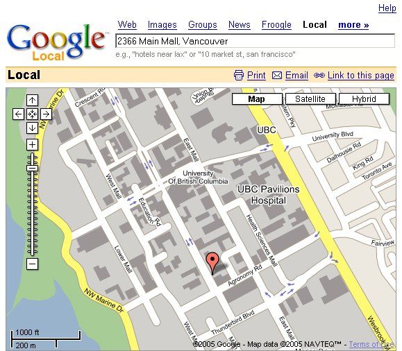
Figure 5. JavaScript client application.

is different between the browsers, and Firefox leaves a        to provide a highly responsive web application. The
horizontal line of white space between the image pieces        system enables simultaneous map and panorama ma-
in the panorama view. However, the response to but-            nipulation without ever reloading the web page. This
ton clicks is faster in Firefox, and some rapid repeated       project is yet another example of how Ajax technology
button presses are lost in Internet Explorer.                  can make web applications appear more like desktop
   The second difficulty in developing this system was         applications, defining why Ajax is currently a hot topic
the problem of debugging the application. This was             in web design.
the largest challenge encountered. In this web-based
environment, experience showed that bugs typically re-         References
sult in a lack of response and no error messages. No
debugging tools were employed, so locating sources of          [1] Apache-Tomcat. http://tomcat.apache.org.
errors in the JavaScript code was achieved using old-          [2] D. Bradley, A. Brunton, M. Fiala, and G. Roth. Image-
fashioned output statements through dynamic HTML.                  based navigation in real environments using panoramas.
Even more challenging was the task of locating bugs in             In IEEE International Workshop on Haptic Audio Vi-
the back-end servlet, because there was no output win-             sual Environments and their Applications, 2005.
dow to even write messages to. Debug statements from           [3] G. Bradski. The OpenCV library. Dr. Dobb’s Journal
the servlet were compiled into XML responses and re-               of Software Tools, 25(11):120, 122–125, nov 2000.
turned to the Ajax engine for display. The difficulty          [4] J.    J.    Garrett.            Ajax:         A     new
in debugging the application added more time to this               approach           to          web          applications
                                                                   (http://www.adaptivepath.com/publications/essays/
project than originally anticipated, and unfortunately
                                                                   archives/000385.php), 2005.
it also limited the number of features that were added         [5] GoogleMaps. http://maps.google.com.
to the final result.                                           [6] GoogleSuggest. http://www.google.com/webhp? com-
                                                                   plete=1&hl=en.
5   Conclusion                                                 [7] L. D. Paulson. Building rich web applications with ajax.
                                                                   IEEE Computer, 38(10):14–17, Oct 2005.

   This project is an implementation of an Ajax web
application. The goal of this project is to extend the
popular Google Maps functionality to include ground-
based 360-degree panoramic images with an interactive
user interface. Asynchronous Ajax communication is
used in conjunction with the Google Maps API, a back-
end java servlet, and a client-side JavaScript engine

                                                           5
You can also read